water2
10
°“√ª√–¬ÿ°µå„™â‡∑§π‘§‰Õ‚´‚∑ª‡æ◊ËÕª√—∫·∫∫®”≈Õß∑“ߧ≥‘µ»“ µ√å ‡æ◊ËÕ∑”𓬰“√‰À≈¢ÕßπÈ”„µâ¥‘π„πæ◊Èπ∑’ËÊ ªπ‡ªóôÕπ “√ÀπŸ¢Õß Õ”‡¿Õ√àÕπæ‘∫Ÿ≈¬å ®—ßÀ«—¥π§√»√’∏√√¡√“™ Isotope Application for Improved Numerical Ground Water Flow Model in Arsenic-polluted Area of Rhonpibul District, Nakhon Si Thammarat Mr. Mesak Milintawisamai*, Ms. Variga Sawaittayotin*, Mr. Peerapong Sunthondecha*, Mr. Manit Sonsuk**, Mr. Kiattipong Khamdee** ∫∑§—¥¬àÕ ®“°°‘®°√√¡°“√∑”‡À¡◊Õß·√॒∫ÿ°„π∑âÕß∑’Ë Õ”‡¿Õ√àÕπæ‘∫Ÿ≈¬å ∑”„Àâ “√ÀπŸ´÷Ë߇ªìπ “√∑’ˇ°‘¥√à«¡ °—π°—∫·√॒∫ÿ°°√–®—¥°√–®“¬‰ª„πæ◊Èπ∑’Ë ·≈– “√ÀπŸ ‡À≈à“π—Èπ‰¥âªπ‡ªóôÕππÈ”„µâ¥‘π °“√»÷°…“«‘®—¬π’È®÷߉¥â ¥”‡π‘π°“√®”≈Õß·∫∫°“√‡§≈◊ËÕπ∑’Ë¢ÕßπÈ”„µâ¥‘π∑—Èß∑’Ë Õ¬Ÿà√–¥—∫µ◊Èπ·≈–≈÷° ‚¥¬„™â‚ª√·°√¡§Õ¡æ‘«‡µÕ√å MODFLOW ´÷Ëß„π°“√§”π«≥‚¥¬„™â‚ª√·°√¡¥—ß°≈à“« ®”‡ªìπµâÕß∑”·∫∫®”≈Õ߇™‘ß·π«§‘¥¢Õß√–∫∫°“√ ‡§≈◊ËÕπ∑’Ë¢ÕßπȔլà“ßßà“¬ (conceptual model) ´÷Ëß „π°“√«‘®—¬π’ȉ¥â«‘‡§√“–Àå¢âÕ¡Ÿ≈‰Õ‚´‚∑ª ‡∂’¬√¢ÕßπÈ” „πæ◊Èπ∑’Ë´÷Ëß “¡“√∂π”¡“™à«¬ √â“ß·∫∫®”≈Õ߇™‘ß ·π«§‘¥‰¥â ∑”„Àâº≈≈—æ∏å· ¥ß°“√‰À≈¢ÕßπÈ”„µâ¥‘π„π æ◊Èπ∑’Ë„°≈⇧’¬ß°—∫º≈°“√«—¥®√‘ß πÕ°®“°π—Èπ ¬—ß *»Ÿπ¬å«‘®—¬·≈–Ωñ°Õ∫√¡¥â“π ‘Ëß·«¥≈âÕ¡ °√¡ à߇ √‘¡§ÿ≥¿“æ ‘Ëß·«¥≈âÕ¡ ‡∑§‚π∏“π’ µ.§≈ÕßÀâ“ Õ.§≈ÕßÀ≈«ß ®.ª∑ÿ¡∏“π’ 12120 ‚∑√. 0-2577-1136 ‚∑√ “√. 0-2577-1138 Environmental Research and Training Center, Department of Environmental Quality Promotion. Technopolis. Klong 5 Klong Luang, Pathumthani 12120 e-mail: [email protected] ** ”π—°ß“πæ≈—ßß“πª√¡“≥Ÿ‡æ◊ËÕ —𵑠∂.«‘¿“«¥’√—ß ‘µ ‡¢µ®µÿ®—°√ °√ÿ߇∑æ¡À“π§√ 10900 ‚∑√. 0-2579-0138 Office of Atomic Energy for Peace, Vibhavadi Rangsit Rd., Chatuchak, Bangkok 10900 Tel. 0-2579-0138 √Ÿª· ¥ß°“√‡°Á∫µ—«Õ¬à“ßπÈ”·≈–«—¥√–¥—∫πÈ”„π∫àÕ∫“¥“≈ ‡§√◊ËÕß¡◊Õ‡°Á∫µ—«Õ¬à“ßπÈ”Ωπ ”À√—∫«‘‡§√“–Àå‰Õ‚´‚∑ª
-
Upload
department-of-environmental-quality-promotion-thailand -
Category
Documents
-
view
212 -
download
0
description
‡æ◊ Ë Õ ∑”𓬰“√‰À≈¢ÕßπÈ ” „µâ ¥ ‘ π „πæ◊ È π ∑’ Ë Ê ªπ‡ªó ô Õ π “√ÀπŸ ¢ Õß Õ”‡¿Õ√à Õ πæ‘ ∫ Ÿ ≈ ¬å ®— ß À«— ¥ π§√»√’ ∏ √√¡√“™ ∫ ∑§— ¥ ¬à Õ √Ÿ ª · ¥ß°“√‡°Á ∫ µ— « Õ¬à “ ßπÈ ” ·≈–«— ¥ √–¥— ∫ πÈ ” „π∫à Õ ∫“¥“≈ 1. Introduction ¢-8 »Ÿ π ¬å « ‘ ® — ¬ ·≈–Ωñ ° Õ∫√¡¥â “ π ‘ Ë ß ·«¥≈â Õ ¡ °√¡ à ß ‡ √‘ ¡ §ÿ ≥ ¿“æ ‘ Ë ß ·«¥≈â Õ ¡
Transcript of water2
°“√ª√–¬ÿ°µå„™â‡∑§π‘§‰Õ‚´‚∑ª‡æ◊ËÕª√—∫·∫∫®”≈Õß∑“ߧ≥‘µ»“ µ√å‡æ◊ËÕ∑”𓬰“√‰À≈¢ÕßπÈ”„µâ¥‘π„πæ◊Èπ∑’ËÊ ªπ‡ªóôÕπ “√ÀπŸ¢ÕßÕ”‡¿Õ√àÕπæ‘∫Ÿ≈¬å ®—ßÀ«—¥π§√»√’∏√√¡√“™Isotope Application for Improved Numerical Ground Water Flow Model inArsenic-polluted Area of Rhonpibul District, Nakhon Si Thammarat
Mr. Mesak Milintawisamai*, Ms. Variga Sawaittayotin*,Mr. Peerapong Sunthondecha*,
Mr. Manit Sonsuk**, Mr. Kiattipong Khamdee**
∫∑§—¥¬àÕ®“°°‘®°√√¡°“√∑”‡À¡◊Õß·√॒∫ÿ°„π∑âÕß∑’Ë
Õ”‡¿Õ√àÕπæ‘∫Ÿ≈¬å ∑”„Àâ “√ÀπŸ´÷Ë߇ªìπ “√∑’ˇ°‘¥√à«¡
°—π°—∫·√॒∫ÿ°°√–®—¥°√–®“¬‰ª„πæ◊Èπ∑’Ë ·≈– “√ÀπŸ
‡À≈à“π—Èπ‰¥âªπ‡ªóôÕππÈ”„µâ¥‘π °“√»÷°…“«‘®—¬π’È®÷߉¥â
¥”‡π‘π°“√®”≈Õß·∫∫°“√‡§≈◊ËÕπ∑’Ë¢ÕßπÈ”„µâ¥‘π∑—Èß∑’Ë
Õ¬Ÿà√–¥—∫µ◊Èπ·≈–≈÷° ‚¥¬„™â ‚ª√·°√¡§Õ¡æ‘«‡µÕ√å
MODFLOW ÷Ëß„π°“√§”π«≥‚¥¬„™â‚ª√·°√¡¥—ß°≈à“«
®”‡ªìπµâÕß∑”·∫∫®”≈Õ߇™‘ß·π«§‘¥¢Õß√–∫∫°“√
‡§≈◊ËÕπ∑’Ë¢ÕßπȔլà“ßßà“¬ (conceptual model) ÷Ëß
„π°“√«‘®—¬π’È ‰¥â«‘‡§√“–Àå¢âÕ¡Ÿ≈‰Õ‚´‚∑ª ‡∂’¬√¢ÕßπÈ”
„πæ◊Èπ∑’Ë´÷Ëß “¡“√∂π”¡“™à«¬ √â“ß·∫∫®”≈Õ߇™‘ß
·π«§‘¥‰¥â ∑”„Àâº≈≈—æ∏å· ¥ß°“√‰À≈¢ÕßπÈ”„µâ¥‘π„π
æ◊È π∑’Ë „°≈⇧’¬ß°—∫º≈°“√«—¥®√‘ß πÕ°®“°π—Èπ ¬—ß
*»Ÿπ¬å«‘®—¬·≈–Ωñ°Õ∫√¡¥â“π ‘Ëß·«¥≈âÕ¡ °√¡ à߇ √‘¡§ÿ≥¿“æ ‘Ëß·«¥≈âÕ¡ ‡∑§‚π∏“π’ µ.§≈ÕßÀâ“ Õ.§≈ÕßÀ≈«ß ®.ª∑ÿ¡∏“π’ 12120 ‚∑√. 0-2577-1136 ‚∑√ “√. 0-2577-1138Environmental Research and Training Center, Department of Environmental Quality Promotion. Technopolis. Klong 5 Klong Luang, Pathumthani 12120 e-mail: [email protected]
** ”π—°ß“πæ≈—ßß“πª√¡“≥Ÿ‡æ◊ËÕ —𵑠∂.«‘¿“«¥’√—ß ‘µ ‡¢µ®µÿ®—°√ °√ÿ߇∑æ¡À“π§√ 10900 ‚∑√. 0-2579-0138Office of Atomic Energy for Peace, Vibhavadi Rangsit Rd., Chatuchak, Bangkok 10900 Tel. 0-2579-0138
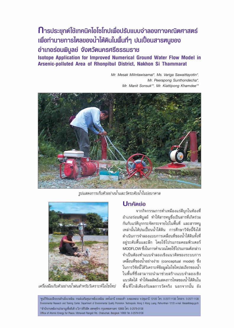
√Ÿª· ¥ß°“√‡°Á∫µ—«Õ¬à“ßπÈ”·≈–«—¥√–¥—∫πÈ”„π∫àÕ∫“¥“≈
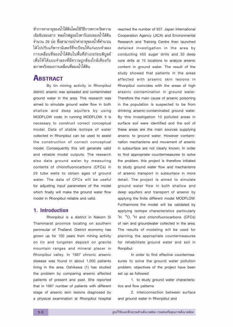
‡§√◊ËÕß¡◊Õ‡°Á∫µ—«Õ¬à“ßπÈ”Ωπ ”À√—∫«‘‡§√“–Àå‰Õ‚´‚∑ª
∑”°“√À“Õ“¬ÿ¢ÕßπÈ”„µâ¥‘π‚¥¬„™â«‘∏’°“√µ√«®«—¥§«“¡
‡¢â¡¢âπ¢Õß “√ §≈Õ‚√ø≈ŸÕÕ‚√§“√å∫Õπ¢ÕßπÈ”„µâ¥‘π
®”π«π 29 ∫àÕ ÷Ëß “¡“√∂π”§à“Õ“¬ÿ¢ÕßπÈ”∑’˧”π«≥
‰¥â ‰ªª√—∫·°âæ“√“¡‘‡µÕ√å∑’Ë®–ªÑÕπ„Àâ·°à·∫∫®”≈Õß
°“√‡§≈◊ËÕπ∑’Ë¢ÕßπÈ”„µâ¥‘π„πæ◊Èπ∑’ËÕ”‡¿Õ√àÕπæ‘∫Ÿ≈¬å
‡æ◊ËÕ„Àâ ‰¥â·∫∫®”≈Õß∑’Ë¡’§«“¡∂Ÿ°µâÕß„°≈⇧’¬ß°—∫
¿“æ®√‘ߢÕß°“√‡§≈◊ËÕπ∑’Ë¢ÕßπÈ”„µâ¥‘π
ABSTRACTBy tin mining activity in Rhonpibul
district, arsenic was spreaded and contaminated
ground water in the area. This research was
aimed to simulate ground water flow in both
shal low and deep aquifers by using
MODFLOW code. In running MODFLOW, it is
necessary to construct correct conceptual
model. Data of stable isotope of water
collected in Rhonpibul can be used to assist
the construction of correct conceptual
model. Consequently this will generate valid
and reliable model outputs. The research
also date ground water by measuring
contents of chlorofluorocarbons (CFCs) in
29 tube wells to obtain ages of ground
water. The data of CFCs will be useful
for adjusting input parameters of the model
which finally will make the ground water flow
model in Rhonpibul reliable and valid.
1. IntroductionRhonpibul is a district in Nakorn Si
Thammarat province locating on southern
peninsular of Thailand. District economy has
grown up for 100 years from mining activity
on tin and tungsten deposit on granite
mountain ranges and mineral placer in
Rhonpibul valley. In 1987 chronic arsenic
disease was found in about 1,000 patients
living in the area. Oshikawa (1) has studied
the problem by comparing arsenic affected
patients of present and past. She reported
that in 1987 number of patients with different
stage of arsenic skin lesions diagnosed by
a physical examination at Rhonpibul hospital
reached the number of 937. Japan International
Cooperation Agency (JICA) and Environmental
Research and Training Centre then launched
detai led invest igat ion in the area by
conducting 450 auger drills and 30 deep
core drills at 15 locations to analyze arsenic
content in ground water. The result of the
study showed that patients in the areas
af fected with arsenic skin lesions in
Rhonpibul coincides with the areas of high
arsenic contamination in ground water.
Therefore the main cause of arsenic poisoning
in the population is suspected to be from
drinking arsenic-contaminated ground water.
By this investigation 10 polluted areas in
surface soil were identified and the soil of
these areas are the main sources supplying
arsenic to ground water. However contami-
nation mechanisms and movement of arsenic
in subsurface are not clearly known. In order
to find appropriate countermeasures to solve
the problem, this project is therefore initiated
to study ground water flow and mechanisms
of arsenic transport in subsurface in more
detail. The project is aimed to simulate
ground water flow in both shallow and
deep aquifers and transport of arsenic by
applying the finite different model MODFLOW.
Furthermore the model will be validated by
applying isotope characteristics particularly2H, 18O, 3H and chlorofluorocarbons (CFCs)
of rain and groundwater collected in the area.
The results of modeling will be used for
planning the appropriate countermeasures
for rehabilitate ground water and soil in
Ronpibul.
In order to find effective countermea-
sures to solve the ground water pollution
problem, objectives of the project have been
set up as followed:
1. to study ground water characteris-
tics and flow patterns
2. interconnection between surface
and ground water in Rhonpibul and
¢-8 »Ÿπ¬å«‘®—¬·≈–Ωñ°Õ∫√¡¥â“π ‘Ëß·«¥≈âÕ¡ °√¡ à߇ √‘¡§ÿ≥¿“æ ‘Ëß·«¥≈âÕ¡
3. to simulate ground water flow and
validate it by applying isotopic signatures of
water in Rhonpibul
History of mining and arsenictoxicity in Rhonpibul
Rhonpibul town has been prospered
from tin mining activity. In the mountainous
area there are several tin deposits attached
with arsenopyrite mineral. Primary deposit
lying in the mountain ranges is a high-grade
vein typed tin mineral. However in the lowland
mineral placers occurs in many locations.
Since arsenic pollution problem occurred,
mining and ore dressing in the area is
prohibited but some small activities of placer
mining are still in operation.
In 1977 an avalanche of mud and
rocks was reported to cause major disaster
in the area. It is believed that the flood and
mud f low has transpor ted t in tai l ing,
arsenopyrite piled up at the foot hill of
Khao Ronna to lowland. Since then the
arsenopyrite is widely distributed in the
area and arsenic concentration in soil is
high. These hot spots of arsenopyrite are
expected to be arsenic sources of ground
water and the main causes of arsenic toxicity
in the area. However arsenopyrite is very
stable mineral, it is impossible to believe
that only existence of arsenopyrite can cause
serious ground water contamination. Theoreti-
cally arsenopyrite can cause contamination
when it is oxidized to form sulfate
compounds and the arsenic can be released
into ground water.
Geological settings and meteo-rology of the study area
Rhonpibul area is situated in the
valley of Khao Ronna and Khao Suangchan
mountains. The mountains are part of Khao
Luang mountain having the highest peak of
925 meters above mean sea level. The area
having elevation higher than 50 meters above
MSL is steep mountainous topoghraphy.
Drainage patterns of the area are tree branch
shape developed in homogeneous rock. In
the valley, Huai Hua Meung and Huai Ronna
streams joining in the north part of Rhonpibul
town forms Klong Nam Khun river flowing
eastward.
Geology of the area can be divided
into 3 units; old sedimentary rock, granite
massive and young alluvium deposit. The old
sedimentary rock was formed in Paleozoic
era and occupies the lower elevation and
foothi l l of the mountains. The rock is
composed of mudstone, siltstone, limestone
and their alterations. The strike of the rock
is nor th-south to nor theast-southwest
direction and dips toward east around
30 degree. In the lowland north to south
stretching black l imestone appears as
monadnock. Granite intrusion aged 187-215
million years covers most of Khoa Luang
mountain. Old sedimentary rock is often
found as a roofpandant of granite massive.
Young alluvium deposit developing in the
eastern part of the area fills a flat area
of less than 40-50 meters in elevation.
Weather of the area is tropical
monsoon. There are 2 seasons; summer
starting from February and rainy season
starting from June. Average annual rainfall
is 2381 mm. Wind direction dominates
from southwest from May to October and
from northeast from November to January.
Average monthly temperature is in the
range of 25.8-28.5oC
2. Methods and MaterialsThe study has been initiated since
October 1998 by conduct ing var ious
types of surveys which are:
2.1 Auger locations was placed at
450 points in the area of 3 X 4 square
kilometers. At each point soil samples at 0.3
and 1 meter depth were collected and
analyzed for arsenic content and conducted
»Ÿπ¬å«‘®—¬·≈–Ωñ°Õ∫√¡¥â“π ‘Ëß·«¥≈âÕ¡ °√¡ à߇ √‘¡§ÿ≥¿“æ ‘Ëß·«¥≈âÕ¡ ¢-9
Table 1. Aquifer characteristics in Rhonpibul
Type of aquifer Range of transmissitivity Range of storage
(m2/min) coefficient
Shallow sand and gravel 6.59x10⁻³ - 1.92x10⁻¹ -
Deep weathered rock 1.01x10⁻³ - 2.86x10⁻² 5.95x10⁻³ - 9.44x10⁻¹
elution test to study the solubility of arsenic
from soil into water. After soil coring,
piezometers were installed to collect shallow
groundwater for analyzing arsenic content
and arsenic speciations; As+3 and As+5 in
water.
2.2 Deep core drills at 15 locations
were done to ident i fy unconsol idated
layer and base rock in the area and 28 wells
of diameter 3-4 inches were installed to
intercept water in each aquifer. Deep and
shallow groundwater was sampled to analyze
arsenic content, arsenic speciation, cations
and anions and 2H, 3H, 18O and 14C. The wells
were also used to conduct pumping test to
obtain aquifer character ist ics such as
transmissitivity and storage coefficients.
2.3 Surface water from streams and
ponds were collected and analyzed for
arsenic content and stable isotope of
hydrogen and oxygen in water. Furthermore
rain at different elevation from 25 - 700
meters above sea level, and tube wells
have been collected every month and every
quarter to analyze isotope characteristics
of the water to study the sources of water
as well as relationship between deep and
shallow aquifer.
2.4 Twenty nine samples of ground
water were collected in May 2000 from tube
wells intercepting shallow and deep aquifers
are sent to IAEA to date the ages of the water
by CFC contents in ground water. This data
will be used to calibrate the numerical flow
model.
Description of the model area,model parameters and boundaries
By the results of geological and
hydrogeological survey in October 1998,
it was found that aquifers in Rhonpibul
can be divided into 3 units; shallow gravel
and sand aquifer, deep aquifer at weathered
rock zone and fractures aquifer in limestone
basement rock. Between sand and weathered
rock aquifers there is a clay layer with
thickness of 5 - 25 meters acts as an
impermeable layer. Pumping test conducted
at 15 locations of shallow and deep aquifers
are used to estimate aquifer characteristics
which can be shown in the table 1. The
parameters of aquifer characteristics such
as transmissivities and storage coefficients
obtained will be used in ground water flow
simulation.
By the result of water sample
analysis, it is shown that contamination
in shallow aquifer is quite extensive. Water
samples collected from dug wells and auger
wells were detected to have high arsenic
up to 12 mg/l at some locations. The
contamination is mainly detected in the
belted zone along Huai Hua Meung river.
In contrast to shallow aquifer, deep aquifer
is not contaminated so high as of the
shallow one. Five of monitoring deep wells
contain high arsenic concentration of 6 mg/l.
Arsenic contaminated ground water does not
uniformly spread over the survey area but
it distributes in several areas along Huai Hua
Meung river. Additionally it was found that
the consistency of the contaminated areas
¢-10 »Ÿπ¬å«‘®—¬·≈–Ωñ°Õ∫√¡¥â“π ‘Ëß·«¥≈âÕ¡ °√¡ à߇ √‘¡§ÿ≥¿“æ ‘Ëß·«¥≈âÕ¡
of shallow and deep aquifers can indicate
how close the relat ion between the
contamination in shallow and deep aquifers
is. Nevertheless ground water flow model
will be constructed to simulate the movement
of ground water in both shallow and deep
aquifers and the model will be validated
by isotope technique in the next part of
the study.
By measuring ground water table
at constructed piezometers, dug wells and
rivers monthly, it is shown that ground
water level flows by topography of the
area. Generally shallow ground water flow
from surrounding mountains to the central
par t of Rhonpibul basin before moving
eastward to the plain. In the plain ground water
flows eastward although scattered flow
patterns were observed due to minute
topography variations. The ground water
flow pattern of deep aquifer is same as of
the shallow one but the pattern of vertical
flow is difficult to obtain. Three dimension
flow simulation will be needed to predict this
flow.
By data of geological loggings and
pattern of ground water flow, the conceptual
model for the area of 3 X 4 km2 was
constructed for simulation with MODFLOW
by dividing model layers into 5 of which layers
1 - 3 represents shallow alluvium sand
aquifer and layer 4 represents clay
impermeable layer. Because of the shapes
and arrangements of limestone aquifer is
not known clearly, the weathered and
fractured rocks are lumped together and
represented by layer 5. Three types of
boundaries are set for the model which are
recharge, river and constant head boundaries.
Since the data on recharge of the area
has never been measured, recharge rate was
arbitrarily set from 200 - 30,000 mm/year.
River boundaries were set on Rhonna, Hua
Muang and Klong Nam Khun river as well
as 8 ponds because the inf i l t rat ion
of river into ground water and outflow
of ground water to rivers is needed to be
simulated.
Conceptual modelThe model covers the entire area
defined by the UTM coordinates of 591500 -
596000 East and 903000 -906000 North.
The area of 3 X 4 km2 was divided in to
coarse grid of 30 rows and 40 columns
which makes each cell covers the area of
100 X 100 m2. In the center par t of
the modeled area where arsenic sources
are located the grid was refined by 2.
As indicated in geological profiles,
the hydrogeological structure of Rhonphibul
basin is ver tically divided into 4 layers
which are sand al luvium, impermeable
clay, weather ing rock and l imestone.
Because of the characteristics of weathering
rock and limestone are not clearly known
and the contamination level in these aquifers
are not high compared with of the alluvium
aquifer, these two geological settings are
then combined and represented by layer 5
in the model. Since arsenic contents in
ground water are very high at many locations
in al luvium aquifer , the aquifer was
represented by layer 1 - 3 for observing
vertical movements of ground water. The
impermeable clay layer is represented by
layer 4.
Because there are no shallow aquifer
in the mountainous area, it is specified as
inactive cells. Rivers that flow within the
basin and ponds are simulated by river
package. Because there is no data on the
recharge and evapotranspiration in the
study area, recharge is therefore arbitrarily
assumed for running the model unt i l
calculated equipotential lines came close to
the measured one and evapotranspiration
rate is not added to the model.
The values of hydraulic conductivity (K)
»Ÿπ¬å«‘®—¬·≈–Ωñ°Õ∫√¡¥â“π ‘Ëß·«¥≈âÕ¡ °√¡ à߇ √‘¡§ÿ≥¿“æ ‘Ëß·«¥≈âÕ¡ ¢-11
shown were derived from data of 30 pumping
tests conducted on the JICA test wells.
Fifteen data of hydraulic conductivity of
shallow and 15 of deep aquifer were plot on
the base map and the conductivity of the
whole area were interpolated from these data
by Krigging method. The distribution of K(x,y)
of shallow and deep aquifers were then
assigned each cell in the model. The model
layer 1 - 3 was assigned by the same K(x,y)
of shallow aquifer while the forth layer was
assigned with K (x,y) of clay specified in
hydrogeological textbook and the fifth
layer was assigned with K (x,y) of deep
aquifer.
Three types of boundaries were applied
to the model which are no flow boundary to
the mountainous area, river boundary to rivers
and ponds and constant head to east of
plain area of modeled area. Since the
abstraction of ground water is not extensive
the simulation was therefore done in steady
state mode for 10 years period.
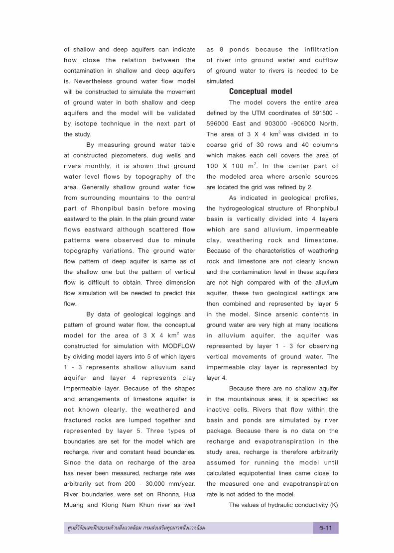
3. Results and DiscussionsResults of steady state simulation
shows that general direction of ground water
flow in both shallow and deep aquifers is from
the west mountainous area to the eastern
plain as shown in Fig. 1 and 2 respectively.
Furthermore shallow ground water flows to
the middle of Rhonpibul valley to discharge
water to Hua Muang, Rhonna and Klong Nam
Khun rivers. The calculated equipotential
lines of ground water table of shallow aquifer
are matched with the measured one very well
as shown in Fig. 3.
Results of deep ground water
simulation shows flow direction of ground
water from the west to the east as same
as the shal low one. However in the
west mountainous area the simulated
ground water table is lower than the
measured one by 3 - 4 meters but in
the east plain area the simulated ground
water table is higher than the measured
one by 2 meters. The discrepancy of
Fig 1. Simulated ground water table of shallow aquifer in Rhonpibul valley
¢-12 »Ÿπ¬å«‘®—¬·≈–Ωñ°Õ∫√¡¥â“π ‘Ëß·«¥≈âÕ¡ °√¡ à߇ √‘¡§ÿ≥¿“æ ‘Ëß·«¥≈âÕ¡
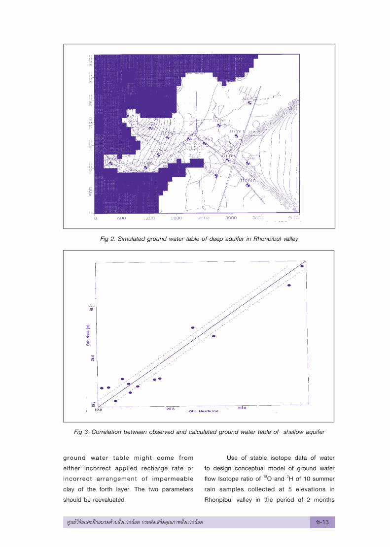
Fig 2. Simulated ground water table of deep aquifer in Rhonpibul valley
Fig 3. Correlation between observed and calculated ground water table of shallow aquifer
ground water table might come from
either incorrect applied recharge rate or
incorrect arrangement of impermeable
clay of the forth layer. The two parameters
should be reevaluated.
Use of stable isotope data of water
to design conceptual model of ground water
flow Isotope ratio of 18O and 2H of 10 summer
rain samples collected at 5 elevations in
Rhonpibul valley in the period of 2 months
»Ÿπ¬å«‘®—¬·≈–Ωñ°Õ∫√¡¥â“π ‘Ëß·«¥≈âÕ¡ °√¡ à߇ √‘¡§ÿ≥¿“æ ‘Ëß·«¥≈âÕ¡ ¢-13
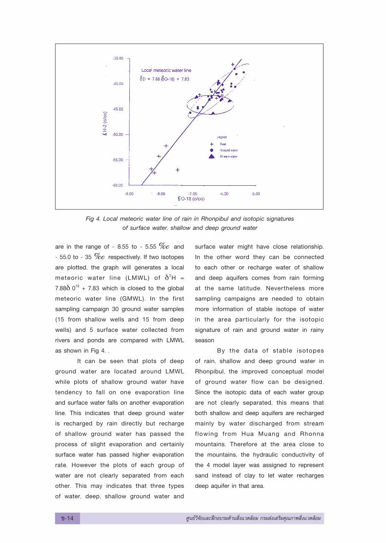
are in the range of - 8.55 to - 5.55 and
- 55.0 to - 35 respectively. If two isotopes
are plotted, the graph will generates a local
meteoric water l ine (LMWL) of δ2H =
7.88δ 018 + 7.83 which is closed to the global
meteoric water line (GMWL). In the first
sampling campaign 30 ground water samples
(15 from shallow wells and 15 from deep
wells) and 5 surface water collected from
rivers and ponds are compared with LMWL
as shown in Fig 4. .
It can be seen that plots of deep
ground water are located around LMWL
while plots of shallow ground water have
tendency to fall on one evaporation line
and surface water falls on another evaporation
line. This indicates that deep ground water
is recharged by rain directly but recharge
of shallow ground water has passed the
process of slight evaporation and certainly
surface water has passed higher evaporation
rate. However the plots of each group of
water are not clearly separated from each
other. This may indicates that three types
of water, deep, shallow ground water and
surface water might have close relationship.
In the other word they can be connected
to each other or recharge water of shallow
and deep aquifers comes from rain forming
at the same latitude. Nevertheless more
sampling campaigns are needed to obtain
more information of stable isotope of water
in the area particularly for the isotopic
signature of rain and ground water in rainy
season
By the data of stable isotopes
of rain, shallow and deep ground water in
Rhonpibul, the improved conceptual model
of ground water flow can be designed.
Since the isotopic data of each water group
are not clearly separated, this means that
both shallow and deep aquifers are recharged
mainly by water discharged from stream
flowing from Hua Muang and Rhonna
mountains. Therefore at the area close to
the mountains, the hydraulic conductivity of
the 4 model layer was assigned to represent
sand instead of clay to let water recharges
deep aquifer in that area.
Fig 4. Local meteoric water line of rain in Rhonpibul and isotopic signaturesof surface water, shallow and deep ground water
¢-14 »Ÿπ¬å«‘®—¬·≈–Ωñ°Õ∫√¡¥â“π ‘Ëß·«¥≈âÕ¡ °√¡ à߇ √‘¡§ÿ≥¿“æ ‘Ëß·«¥≈âÕ¡
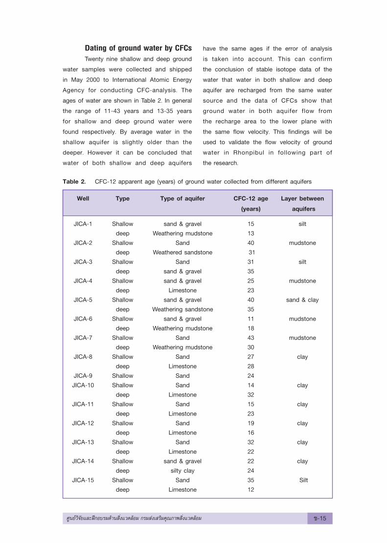
Dating of ground water by CFCsTwenty nine shallow and deep ground
water samples were collected and shipped
in May 2000 to International Atomic Energy
Agency for conducting CFC-analysis. The
ages of water are shown in Table 2. In general
the range of 11-43 years and 13-35 years
for shallow and deep ground water were
found respectively. By average water in the
shallow aquifer is slightly older than the
deeper. However it can be concluded that
water of both shallow and deep aquifers
have the same ages if the error of analysis
is taken into account. This can confirm
the conclusion of stable isotope data of the
water that water in both shallow and deep
aquifer are recharged from the same water
source and the data of CFCs show that
ground water in both aquifer flow from
the recharge area to the lower plane with
the same flow velocity. This findings will be
used to validate the flow velocity of ground
water in Rhonpibul in following part of
the research.
Table 2. CFC-12 apparent age (years) of ground water collected from different aquifers
Well Type Type of aquifer CFC-12 age Layer between
(years) aquifers
JICA-1 Shallow sand & gravel 15 siltdeep Weathering mudstone 13
JICA-2 Shallow Sand 40 mudstonedeep Weathered sandstone 31
JICA-3 Shallow Sand 31 siltdeep sand & gravel 35
JICA-4 Shallow sand & gravel 25 mudstonedeep Limestone 23
JICA-5 Shallow sand & gravel 40 sand & claydeep Weathering sandstone 35
JICA-6 Shallow sand & gravel 11 mudstonedeep Weathering mudstone 18
JICA-7 Shallow Sand 43 mudstonedeep Weathering mudstone 30
JICA-8 Shallow Sand 27 claydeep Limestone 28
JICA-9 Shallow Sand 24JICA-10 Shallow Sand 14 clay
deep Limestone 32JICA-11 Shallow Sand 15 clay
deep Limestone 23JICA-12 Shallow Sand 19 clay
deep Limestone 16JICA-13 Shallow Sand 32 clay
deep Limestone 22JICA-14 Shallow sand & gravel 22 clay
deep silty clay 24JICA-15 Shallow Sand 35 Silt
deep Limestone 12
»Ÿπ¬å«‘®—¬·≈–Ωñ°Õ∫√¡¥â“π ‘Ëß·«¥≈âÕ¡ °√¡ à߇ √‘¡§ÿ≥¿“æ ‘Ëß·«¥≈âÕ¡ ¢-15
4. ConclusionsTo make a valid numerical ground
water flow model, both correct conceptual
model and true input parameters are
needed. This research demonstrates that
by applying isotopic data of water, the
correct conceptual model can be designed.
Fur thermore tracer technique like CFCs
is not only useful in designing the correct
conceptual model but also useful in validating
the outputs of the ground water flow model.
However to use the techniques successfully,
experienced and skillful persons are needed.
5. AcknowledgementsThe authors would like to thank
International Atomic Energy Agency (IAEA)
for supporting this project by providing
modeling softwares as well as conducting
stable isotope and CFCs analyses. Particularly
the encouragement of Dr. Yucel Yutserver,
IAEA expert in proposing the research to be
included in IAEA Regional Cooperation
Agreement program made this research
project possible.
6. References1. Shoko Oshikawa, Personal communication.
2. Japan International Cooperation Agency,
Report on Environmental Management
Planning Survey for Arsenic Contaminated
Area of the Nakhon Si Thammarat
Province in the Kingdom of Thailand.
December 1999.
¢-16 »Ÿπ¬å«‘®—¬·≈–Ωñ°Õ∫√¡¥â“π ‘Ëß·«¥≈âÕ¡ °√¡ à߇ √‘¡§ÿ≥¿“æ ‘Ëß·«¥≈âÕ¡