CANADIAN BOARD OF EXAMINERS FOR PROFESSIONAL SURVEYORS … 2010/C4 Coordinate Systems... ·...
3
Exam C-4 Coordinate Systems 2010 10 1 of 3 CANADIAN BOARD OF EXAMINERS FOR PROFESSIONAL SURVEYORS C-4 COORDINATE SYSTEMS & MAP PROJECTIONS October 2010 Although programmable calculators may be used, candidates must show all formulae used, the substitution of values into them, and any intermediate values to 2 more significant figures than warranted by the answer. Otherwise, full marks may not be awarded even though the answer is numerically correct. Note: This examination consists of 7 questions on a total of 3 pages. Marks Q. No Time: 3 hours Value Earned 1. A large (several kilometers in diameter) engineering structure, to be positioned on a site, is designed and specified in an arbitrary right-handed (x, y, z) Cartesian coordinate system. The x-axis of the system is aligned along two physically marked points on the proposed site with one of the points serving as the origin of the local coordinate system. With regard to coordinate system transformation, explain (without providing any specific equations) the step-by-step procedure for transforming (x, y, z) coordinates of any point in the structure to its corresponding latitude, longitude and orthometric height coordinates; and indicate in each step, which elements must be specified for the transformation solution to be possible. 16 2. The map projection equations relating map projection coordinates (x, y) with the corresponding geographic coordinates (φ, λ) are given as x Rλ = ln tan 45 2 y R ϕ = + o where R is the mean radius of the spherical earth with the following as the first derivatives of the relationships: 0 x ϕ = cos R y ϕ ϕ = x R λ = 0 y λ = Answer the following questions: a. Determine the area distortion factor and indicate if this projection is equal-area. b. Determine if this projection is conformal and explain if directions of maximum and minimum distortions exist in the projection. c. Determine the grid azimuth of any of the projected meridians. d. Given a curve of constant azimuth of 30° on the spherical earth, determine the distortion in the azimuth of this curve on that projection. e. Based on your answers in the above calculations, explain what a loxodrome will look like on this projection and suggest the most likely name for this type of projection. 5 3 2 5 3 3. Clearly explain the essential differences between the following terms as used in Geomatics. Your explanation must clearly demonstrate your understanding of every important term involved in each question. a. Geodetic datum and geodetic coordinate reference system. b. NAD83 original and NAD83(CSRS) datums. 5 3
Transcript of CANADIAN BOARD OF EXAMINERS FOR PROFESSIONAL SURVEYORS … 2010/C4 Coordinate Systems... ·...
Exam C-4 Coordinate Systems 2010 10 1 of 3
CANADIAN BOARD OF EXAMINERS FOR PROFESSIONAL SURVEYORS
C-4 COORDINATE SYSTEMS & MAP PROJECTIONS October 2010
Although programmable calculators may be used, candidates must show all formulae used, the
substitution of values into them, and any intermediate values to 2 more significant figures than
warranted by the answer. Otherwise, full marks may not be awarded even though the answer is
numerically correct.
Note: This examination consists of 7 questions on a total of 3 pages.
Marks
Q. No Time: 3 hours Value Earned
1.
A large (several kilometers in diameter) engineering structure, to be
positioned on a site, is designed and specified in an arbitrary right-handed
(x, y, z) Cartesian coordinate system. The x-axis of the system is aligned
along two physically marked points on the proposed site with one of the
points serving as the origin of the local coordinate system.
With regard to coordinate system transformation, explain (without
providing any specific equations) the step-by-step procedure for
transforming (x, y, z) coordinates of any point in the structure to its
corresponding latitude, longitude and orthometric height coordinates; and
indicate in each step, which elements must be specified for the
transformation solution to be possible.
16
2.
The map projection equations relating map projection coordinates (x, y)
with the corresponding geographic coordinates (φ, λ) are given as
x Rλ= ln tan 452
y Rϕ
= +
o
where R is the mean radius of the spherical earth with the following as the
first derivatives of the relationships:
0xϕ = cos
Ryϕ
ϕ= x Rλ = 0yλ =
Answer the following questions:
a. Determine the area distortion factor and indicate if this projection is
equal-area.
b. Determine if this projection is conformal and explain if directions of
maximum and minimum distortions exist in the projection.
c. Determine the grid azimuth of any of the projected meridians.
d. Given a curve of constant azimuth of 30° on the spherical earth,
determine the distortion in the azimuth of this curve on that projection.
e. Based on your answers in the above calculations, explain what a
loxodrome will look like on this projection and suggest the most likely
name for this type of projection.
5
3
2
5
3
3.
Clearly explain the essential differences between the following terms as
used in Geomatics. Your explanation must clearly demonstrate your
understanding of every important term involved in each question.
a. Geodetic datum and geodetic coordinate reference system.
b. NAD83 original and NAD83(CSRS) datums.
5
3
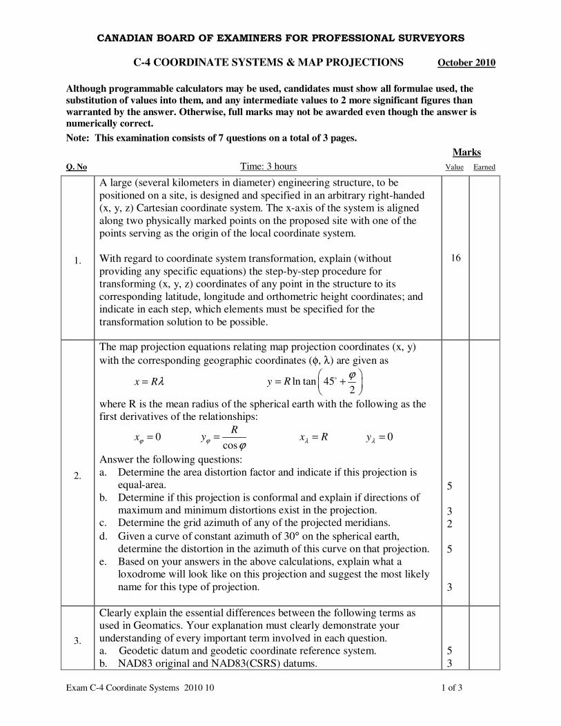
Exam C-4 Coordinate Systems 2010 10 2 of 3
4.
The point scale factor (k) and the meridian convergence (C) at any given
point (φ, λ) on a UTM projection can be approximated using the following
formulas:
( )
+=
2
cos1
2
0
φLkk ;
( ) ( ) ( )CM
C λλφ −×−= tansintan
where L = ( )CM
λλ − in radians; CM
λ is the longitude of the central
meridian; k0 is the scale factor at the central meridian; and φ and λ are the
latitude and longitude values of the given point.
a. At what distance (in degrees, minutes, seconds) away from the central
meridian, along the equator, is the UTM scale distortion equal to zero?
b. If a scaling accuracy ratio of 1:10,000 is to be maintained in the given
zone and a Modified Transverse Mercator (MTM) projection (similar to
UTM) is to be used, determine minimum and maximum scale factors
and the maximum width (in degrees, minutes, seconds) of the zone, at
the equator.
c. Given the central meridian of a UTM zone 10 as 123° W; the geodetic
coordinates of point B as Latitude = 50°00′0.000″ N, Longitude =
124°00′10.000″ W; and the corresponding UTM coordinates of point B
as Northing = 5539112.50 m, Easting = 428134.53 m; answer the
following.
i. Calculate (on the UTM plane) the meridian convergence (to the
nearest arc second) and the point scale factor (to six decimal
places) for point B. Would this convergence angle change for the
MTM zone if the MTM projection zone and the UTM zone have
the same central meridian? Clearly explain your answers.
ii. If the Modified Transverse Mercator (MTM) projection zone in
(b) above and the UTM zone have the same central meridian,
what are the MTM coordinates of point B (assuming the MTM
False Easting = 4,500,000.00 m, False Northing = 0.00 m)?
4
5
6
10
5.
Different provinces in Canada use different map projections for surveying
and the compilation of engineering maps, for example, Nova Scotia uses the
Modified Transverse Mercator projection and Prince Edward Island uses the
Stereographic Double projection. Describe the map projections used in
these two provinces with regard to their aspects, distortion characteristics,
developable shapes, and types of standard parallel or standard meridian
used. Discuss one important reason why different map projections are being
used in the two provinces.
6
6.
There is usually some confusion about the relationships amongst the three-
dimensional positions (X, Y, Z) in GPS networks, three-dimensional
positions (x, y, z) in engineering micro-networks, and three-dimensional
positions (Easting, Northing, Orthometric Height) in topographic mapping.
Explain the differences among these three sets of positions with regard to
their respective coordinate systems (describing their origins and orientations
of their axes in space).
12
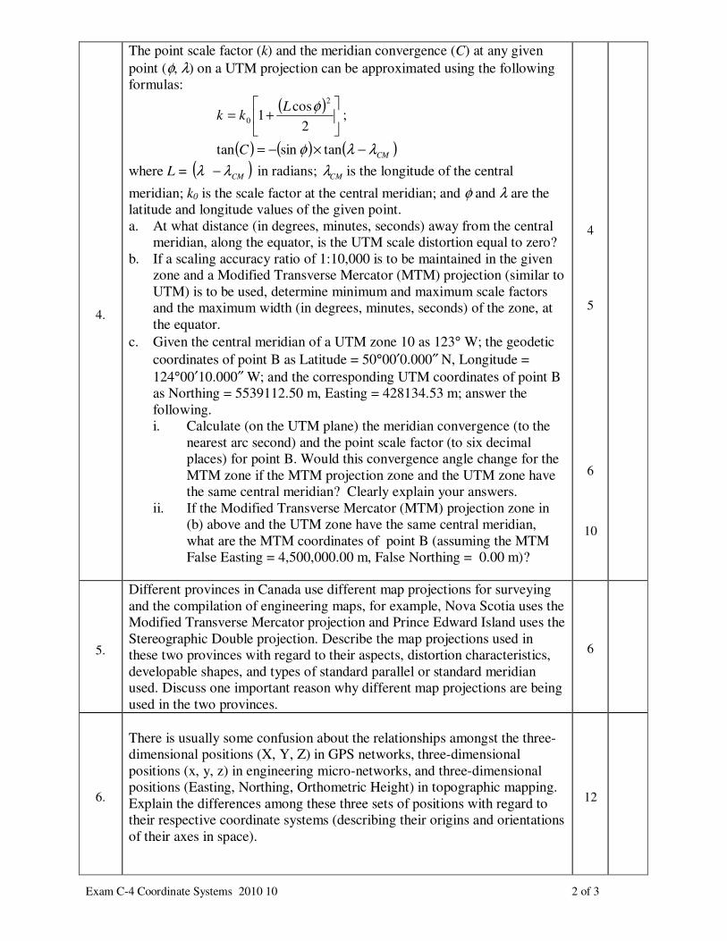
Exam C-4 Coordinate Systems 2010 10 3 of 3
7.
Answer the following with respect to the (x, y, z) astronomic coordinate
system.
a. Define the (x, y, z) astronomic coordinate system with regard to its
origin and the orientation of its axes.
b. Determine (with reasons) which of the following would affect the
astronomic latitude and longitude coordinates of a given point on the
Earth’s surface:
i) a translation of the coordinate origin of the (x, y, z) system;
ii) a general rotation of the (x, y, z) system
c. Determine (with reasons for each case) which of the following would
be affected if the (x, y, z) axes are rotated about the z-axis: astronomic
latitude, astronomic longitude, astronomic azimuth.
d. Assume that the (x, y, z) axes of an ellipsoid coordinate system are
parallel to the (x, y, z) astronomic coordinate system. Explain if the
geodetic and astronomic meridian planes for a given point on the
Earth’s surface are also parallel. Your explanation must demonstrate
that you understand what the two meridian planes are.
4
4
3
4
Total Marks: 100
Given: ( ),X f φ λ= ( ),Y g φ λ=
2
22
2
1R
gfm
φφ += ;
φλλ
22
222
2cosR
gfm
+= ;
( )φ
λφλφ
cos
22
R
ggffp
+=
Σ
Σ′
d
d=
pAmm ′× sin21
( ) ( )22
sin
λφλφλφφλ
λφφλ
ggffgfgf
gfgfAp
++−
−=′
φ
φµ
f
gm =tan
AfAf
AgAgs
sincoscos
sincoscostan
λφ
λφ
φ
φµ
+
+=
( )sm
smAµµ
µµ
tantan1
tantan180tan
+
−=′−o
( )cos cosx N h φ λ= +
( )cos siny N h φ λ= +
( )21 sinz e N h φ = − +
( ) ( ) ( )1 2 3
CT CT Gr r R R R rα β γ∆ = ∆ + ∆
( )3 0 0 2 0 1 0( tan ) ( )LG LA
r R R R rη φ ξ η∆ = − × ∆
3 0 2 0 2( ) ( )
2
G LGr R R P rπ
π λ φ∆ = − − × ∆