Lidar-Based Retrievals of the Microphysical Properties of...
1
β lid = 2 A , β rad = 24 π 3 k 2 λ 4 V 2 V =σ V π 6 D ref 3 −δ V D δ V P (180) 4 π 3 8π β ' rad β ' lid = 8π 3 k 2 λ 4 D eff V 2 V P (180) 4 π 3 8π β ' rad β ' lid = 12π 3 k 2 λ 4 V 2 A A =σ A π 4 D ref 2−δ A D δ A N = β ' lid 2 P (180) 4 π A D eff = 3 V 2 A WC = 2 3 Nρ A D eff Assumptions for phase separation Assumptions for phase separation - Even Ice Distribution vertically - Even Ice Distribution vertically throughout cloud throughout cloud - Ice amount directly below cloud is - Ice amount directly below cloud is same as inside cloud layer same as inside cloud layer Time (UT) ) m k ( e d u t i t l A Radar Backscatter Cross−Section for Water Only 13:00 14:00 15:00 16:00 17:00 18:00 19:00 0.2 0.4 0.6 0.8 1.0 1.2 1.4 1.6 1.8 2.0 2.2 2.4 2.6 2.8 3.0 3.2 3.4 3.6 3.8 1/(m str) 1e−14 1e−13 1e−12 1e−11 1e−10 1e−9 1e−8 1e−7 Time (UT) ) m k ( e d u t i t l A Radar Backscatter Cross−Section for Ice Only 13:00 14:00 15:00 16:00 17:00 18:00 19:00 0.2 0.4 0.6 0.8 1.0 1.2 1.4 1.6 1.8 2.0 2.2 2.4 2.6 2.8 3.0 3.2 3.4 3.6 3.8 1/(m str) 1e−14 1e−13 1e−12 1e−11 1e−10 1e−9 1e−8 1e−7 Time (UT) ) m k ( e d u t i t l A Radar Backscatter Cross−Section 13:00 14:00 15:00 16:00 17:00 18:00 19:00 0.2 0.4 0.6 0.8 1.0 1.2 1.4 1.6 1.8 2.0 2.2 2.4 2.6 2.8 3.0 3.2 3.4 3.6 3.8 1/(m str) 1e−14 1e−13 1e−12 1e−11 1e−10 1e−9 1e−8 1e−7 Time (UT) ) m k ( e d u t i t l A Lidar Backscatter Cross−Section for Water Only 13:00 14:00 15:00 16:00 17:00 18:00 19:00 0.2 0.4 0.6 0.8 1.0 1.2 1.4 1.6 1.8 2.0 2.2 2.4 2.6 2.8 3.0 3.2 3.4 3.6 3.8 1/(m str) 1e−6 1e−5 1e−4 1e−3 Time (UT) ) m k ( e d u t i t l A Lidar Backscatter Cross−Section for Ice Only 13:00 14:00 15:00 16:00 17:00 18:00 19:00 0.2 0.4 0.6 0.8 1.0 1.2 1.4 1.6 1.8 2.0 2.2 2.4 2.6 2.8 3.0 3.2 3.4 3.6 3.8 1/(m str) 1e−6 1e−5 1e−4 1e−3 Time (UT) ) m k ( e d u t i t l A Lidar Backscatter Cross−Section 13:00 14:00 15:00 16:00 17:00 18:00 19:00 0.2 0.4 0.6 0.8 1.0 1.2 1.4 1.6 1.8 2.0 2.2 2.4 2.6 2.8 3.0 3.2 3.4 3.6 3.8 1/(m str) 1e−6 1e−5 1e−4 1e−3 Time (UT) ) m k ( e d u t i t l A Effective Diameter (Ice Only) 13:00 14:00 15:00 16:00 17:00 18:00 19:00 0.2 0.4 0.6 0.8 1.0 1.2 1.4 1.6 1.8 2.0 2.2 2.4 2.6 2.8 3.0 3.2 3.4 3.6 3.8 microns 20 40 60 80 100 120 Time (UT) ) m k ( e d u t i t l A Number Density (Ice Only) 13:00 14:00 15:00 16:00 17:00 18:00 19:00 0.2 0.4 0.6 0.8 1.0 1.2 1.4 1.6 1.8 2.0 2.2 2.4 2.6 2.8 3.0 3.2 3.4 3.6 3.8 1/L 1 5 10 Time (UT) ) m k ( e d u t i t l A Ice Water Content 13:00 14:00 15:00 16:00 17:00 18:00 19:00 0.2 0.4 0.6 0.8 1.0 1.2 1.4 1.6 1.8 2.0 2.2 2.4 2.6 2.8 3.0 3.2 3.4 3.6 3.8 g/m^3 0.01 0.02 0.03 0.04 0.05 Time (UT) ) m k ( e d u t i t l A Effective Diameter 13:00 14:00 15:00 16:00 17:00 18:00 19:00 0.2 0.4 0.6 0.8 1.0 1.2 1.4 1.6 1.8 2.0 2.2 2.4 2.6 2.8 3.0 3.2 3.4 3.6 3.8 microns 20 40 60 80 100 120 140 160 180 200 Time (UT) ) m k ( e d u t i t l A Number Density 13:00 14:00 15:00 16:00 17:00 18:00 19:00 0.2 0.4 0.6 0.8 1.0 1.2 1.4 1.6 1.8 2.0 2.2 2.4 2.6 2.8 3.0 3.2 3.4 3.6 3.8 1/L 1 10 1e2 1e3 1e4 Time (UT) ) m k ( e d u t i t l A Water Content 13:00 14:00 15:00 16:00 17:00 18:00 19:00 0.2 0.4 0.6 0.8 1.0 1.2 1.4 1.6 1.8 2.0 2.2 2.4 2.6 2.8 3.0 3.2 3.4 3.6 3.8 g/m^3 0.02 0.04 0.06 0.08 0.1 0.12 0.14 METHOD METHOD Donovan and Van Lammeren (2001, Revised) MIXED PHASE ICE ONLY Assumed Size Distribution n ( D ) = aD α exp( −bD γ ) α liquid =α ice = 2 γ liquid =γ ice = 1 σ a = 1 δ a = 2 σ v = 1 δ v = 2 α liquid =α ice = 2 γ liquid =γ ice = 1 σ a = 1 δ a = 2 δ v = 2 σ v = 0.2 Introduction The Arctic has long presented itself as a challenging environment for scien- tists and instruments alike. Because of this, there exists a relative lack of un- derstanding and observations of meteorological phenomena found in these unforgiving locations. One example of such phenomena is the mixed-phase stratus decks which last for extended periods of time over large spatial scales. The longevity of these structures defies our current state of knowledge. Tra- ditional theory would allow the ice portion of the cloud to rapidly consume liquid present in the cloud layer until it has glaciated. The high amount of liquid present for long time periods, however, demonstrates that unknown mechanisms are involved in their development and maintenance. In order to better understand these and other Arctic cloud structures, the Uni- versity of Wisconsin Lidar Group has developed and deployed a remotely op- erated High Spectral Resolution Lidar (UW-AHSRL, Eloranta, 2004). This in- strument has collected data sets in both Barrow Alaska (71.2 N, 156.4 W) during the Mixed Phase Arctic Clouds Experiment (M-PACE, Harrington and Verlinde, 2004 ) as well as in Eureka, Canada (80.0 N, 85.9 W). In addition to tra- ditional HSRL based measurements of aerosol backscatter cross-section and depolarization ratio, we have developed and continue to improve a suite of cloud microphysical retrievals modeled after the technique implemented by Donnovan and Van Lammeren (2001). In conjunction with a NOAA ETL Milli- meter Cloud Radar (MMCR), AHSRL measurements are being utilized to esti- mate values of effective diameter, number density and water content. Here, we illustrate examples of these retrievals, as well as comparisons of these techniques with in-situ measurements. Long-term analysis of this data will include the development of climatology for these clouds, as well as utili- zation of these measurements to validate atmospheric simulations of these clouds. Lidar-Based Retrievals of the Microphysical Properties of Mixed- Phase Arctic Stratus Clouds and Precipitation Gijs de Boer, Edwin W. Eloranta Department of Atmospheric and Oceanic Sciences The University of Wisconsin - Madison The modified sea-tainer housing the AHSRL together with the NOAA MMCR in Eureka, Canada. The instruments have recorded 10 months of nearly con- tinual data. Sea Kara Bay A r c t i c Beaufort Laptev Barents Sea Greenland Baffin Sea Sea Sea Lake Great Bear e Sea Chukchi average minimum extent of sea ice n e L a n o k u Y r e v i R Lake Onega v i R r e n e k e i z East Siberian O c e a n Denmark Strait avis Strait Norwegian Sea c e P a r o h Sea h k u a n o Dvina g e h c y V a d S e v e rn aya R U S S I A C A N A D A NORWAY SWEDEN FINLAND (DENMARK) Greenland (NORWAY) Svalbard (NORWAY) (NORWAY) UNITED STATES Jan Mayen 10˚C (50˚ Ju Dawson Inuvik Barrow Cherskiy Arkhangel'sk orse fe y Bay Prudhoe Fairbanks Alert Nord Tasiilaq Kangerlussuaq (Ammassalik) Oymyakon Verkhoyansk Bjørnøya Tiksi Qaanaaq (Thule) Kaujuitoq (Resolute) bridge ay r Bay) it Narsarsuaq b) Itseqqortoormiit (Scoresbysund) Noril Dikson e on Yakutsk Pevek ulse Bay Tromsø (Søndre Strømfjord) Nuuk (Godthåb) Longyearbyen Murmansk Island Wrangel NOVAYA ZEMLYA FRANZ JOSEF LAND SEVERNAYA ZEMLYA NEW SIBERIAN ISLANDS Ellesmere Island ISLANDS QUEEN ELIZABETH Banks Island Victoria Island Baffin Island A 0 6 0 7 North Pole 0 8 0 8 0 7 EUREKA EUREKA BARROW BARROW Remaining Challenges - Radar cannot resolve smallest particles - Crystal habit estimation through measurements - Improved separation of phase - Improved estimation/measurement of aerosol effects Possible Additional Information Sources - Other instrumentation/measurements - Radar fall velocity - Aerosol measurements from Eureka site - Numerical simulation of cloud structures ILRC XXIII July 24-28 Nara, Japan In-Situ Validation Time (UT) Altitude (km) Radar Backscatter Cross−Section 21:55 22:00 22:05 0.2 0.4 0.6 0.8 1.0 1.2 1.4 1.6 1.8 1/(m str) 1e−14 1e−13 1e−12 1e−11 1e−10 1e−9 1e−8 1e−7 0 50 100 150 200 250 300 350 400 450 −600 −400 −200 0 200 400 600 800 1000 Effective Diameter 10/09/04 Effective Diameter ( µm) Height From Cloud Base (m) Lidar−Radar Retrieval In−Situ Measurements 10 −2 10 −1 10 0 10 1 10 2 10 3 10 4 −600 −400 −200 0 200 400 600 800 1000 Number Density 10/09/04 Number Density (1/L) Height From Cloud Base (m) Lidar−Radar Retrieval In−Situ Measurements 0 0.05 0.1 0.15 0.2 0.25 0.3 0.35 0.4 −600 −400 −200 0 200 400 600 800 1000 Water Content 10/09/04 Water Content (g/m 3 ) Height From Cloud Base (m) Lidar−Radar Retrieval In−Situ Measurements Time (UT) Altitude (km) Lidar Backscatter Cross−Section 21:55 22:00 22:05 0.2 0.4 0.6 0.8 1.0 1.2 1.4 1.6 1.8 1/(m str) 1e−6 1e−5 1e−4 1e−3 0 100 200 300 400 500 −600 −400 −200 0 200 400 600 800 1000 Effective Diameter ( µm) Height From Cloud Base (m) Effective Diameter 10/09/04 Lidar−Radar Retrieval In−Situ Measurements (water) In−Situ Measurements (ice) 10 −2 10 0 10 2 10 4 10 6 −600 −400 −200 0 200 400 600 800 1000 Number Density 10/09/04 Number Density (1/L) Height From Cloud Base (m) Lidar−Radar Retrieval In−Situ Measurements (water) In−Situ Measurements (ice) −0.1 0 0.1 0.2 0.3 0.4 0.5 0.6 −600 −400 −200 0 200 400 600 800 1000 Water Content 10/09/04 Water Content (g/m 3 ) Height From Cloud Base (m) Lidar−Radar Retrieval In−Situ Measurements (water) In−Situ Measurements (ice) Lidar and radar backscatter cross-section (left top and bottom) from October 9, 2004 from 21:50-22:10 UTC. Comparisons of lidar-radar retrieved ef- fective diameter (2nd column), number density (3rd column) and water conent (right-most column) with in-situ measurements from the citation air- craft. Comparisons are done for combined phase (using volume filling fraction, top row) and ice only (bottom row). Aircraft data thanks to Gong Zhang and Greg McFarquhar (U. Illinois). Microphysical Information D eff (µm) Altitude (km) Single Retrieval for Ice Phase Only 0 50 100 150 200 250 300 350 0.2 0.4 0.6 0.8 1.0 1.2 1.4 1.6 1.8 2.0 1/L 1 10 1e2 1e3 1e4 1e5 D eff (µm) Altitude (km) Single Retrieval for Mixed Phase 0 50 100 150 200 250 300 350 0.2 0.4 0.6 0.8 1.0 1.2 1.4 1.6 1.8 2.0 1/L 1 10 1e2 1e3 1e4 1e5 D eff (µm) Altitude (km) Single Retrieval for Mixed Phase 0 50 100 150 200 250 300 350 0.2 0.4 0.6 0.8 1.0 1.2 1.4 1.6 1.8 2.0 1/L 1 10 1e2 1e3 1e4 1e5 Effective diameter-altitude plots color contoured by number density for mixed phase spheres (top-left), mixed phase non-spheres (top-right) and ice phase only (bottom left). The bottom right image shows vertical profiles of effective diameter, number density and water content for non-spherical mixed phase. Basically, spheres...But doesn’t need to be. Here, we use a volume filling frac- tion, reducing the volume of ice.
Transcript of Lidar-Based Retrievals of the Microphysical Properties of...
β lid = 2 A,β rad = 24π 3k 2
λ4 V 2
V = σVπ6Dref
3−δ V DδV
P(180)4π38π
β 'radβ 'lid
= 8π 3k 2
λ4 Deff
V 2
V
P(180)4π38π
β 'radβ 'lid
= 12π 3k 2
λ4
V 2
A
A = σAπ4Dref
2−δ A Dδ A
N = β 'lid
2 P(180)4π
A
Deff =3 V2 A
WC = 23Nρ A Deff
Assumptions for phase separationAssumptions for phase separation- Even Ice Distribution vertically - Even Ice Distribution vertically throughout cloudthroughout cloud- Ice amount directly below cloud is - Ice amount directly below cloud is same as inside cloud layersame as inside cloud layer
Time (UT)
)mk( edutitl A
Radar Backscatter Cross−Section for Water Only
13:00 14:00 15:00 16:00 17:00 18:00 19:000.20.40.60.81.01.21.41.61.82.02.22.42.62.83.03.23.43.63.8
1/(m str)1e−14
1e−13
1e−12
1e−11
1e−10
1e−9
1e−8
1e−7
Time (UT)
)mk( edutit lA
Radar Backscatter Cross−Section for Ice Only
13:00 14:00 15:00 16:00 17:00 18:00 19:000.20.40.60.81.01.21.41.61.82.02.22.42.62.83.03.23.43.63.8
1/(m str)1e−14
1e−13
1e−12
1e−11
1e−10
1e−9
1e−8
1e−7
Time (UT)
)mk( edutit lA
Radar Backscatter Cross−Section
13:00 14:00 15:00 16:00 17:00 18:00 19:000.20.40.60.81.01.21.41.61.82.02.22.42.62.83.03.23.43.63.8
1/(m str)1e−14
1e−13
1e−12
1e−11
1e−10
1e−9
1e−8
1e−7
Time (UT)
)mk( edutit lA
Lidar Backscatter Cross−Section for Water Only
13:00 14:00 15:00 16:00 17:00 18:00 19:000.20.40.60.81.01.21.41.61.82.02.22.42.62.83.03.23.43.63.8
1/(m str)1e−6
1e−5
1e−4
1e−3
Time (UT)
)mk( edutitl A
Lidar Backscatter Cross−Section for Ice Only
13:00 14:00 15:00 16:00 17:00 18:00 19:000.20.40.60.81.01.21.41.61.82.02.22.42.62.83.03.23.43.63.8
1/(m str)1e−6
1e−5
1e−4
1e−3
Time (UT)
)mk( edutitlA
Lidar Backscatter Cross−Section
13:00 14:00 15:00 16:00 17:00 18:00 19:000.20.40.60.81.01.21.41.61.82.02.22.42.62.83.03.23.43.63.8
1/(m str)1e−6
1e−5
1e−4
1e−3
Time (UT)
)mk( edutitlA
Effective Diameter (Ice Only)
13:00 14:00 15:00 16:00 17:00 18:00 19:000.20.40.60.81.01.21.41.61.82.02.22.42.62.83.03.23.43.63.8
microns
20
40
60
80
100
120
Time (UT)
)mk( edutit lA
Number Density (Ice Only)
13:00 14:00 15:00 16:00 17:00 18:00 19:000.20.40.60.81.01.21.41.61.82.02.22.42.62.83.03.23.43.63.8
1/L1
5
10
Time (UT)
)mk( edutitlA
Ice Water Content
13:00 14:00 15:00 16:00 17:00 18:00 19:000.20.40.60.81.01.21.41.61.82.02.22.42.62.83.03.23.43.63.8
g/m^3
0.01
0.02
0.03
0.04
0.05
Time (UT)
)mk( edutitlA
Effective Diameter
13:00 14:00 15:00 16:00 17:00 18:00 19:000.20.40.60.81.01.21.41.61.82.02.22.42.62.83.03.23.43.63.8
microns
20
40
60
80
100
120
140
160
180
200
Time (UT)
)mk( edutitlA
Number Density
13:00 14:00 15:00 16:00 17:00 18:00 19:000.20.40.60.81.01.21.41.61.82.02.22.42.62.83.03.23.43.63.8
1/L1
10
1e2
1e3
1e4
Time (UT)
)mk( edutitlA
Water Content
13:00 14:00 15:00 16:00 17:00 18:00 19:000.20.40.60.81.01.21.41.61.82.02.22.42.62.83.03.23.43.63.8
g/m^3
0.02
0.04
0.06
0.08
0.1
0.12
0.14
METHODMETHODDonovan and Van Lammeren (2001, Revised)
MIXED PHASEICE ONLY Assumed Size Distribution
€
n(D) = aDα exp(−bDγ )€
α liquid = α ice = 2
€
γ liquid = γ ice =1
€
σ a =1
€
δa = 2
€
σ v =1
€
δv = 2€
α liquid = α ice = 2
€
γ liquid = γ ice =1
€
σ a =1
€
δa = 2
€
δv = 2
€
σ v = 0.2
Introduction
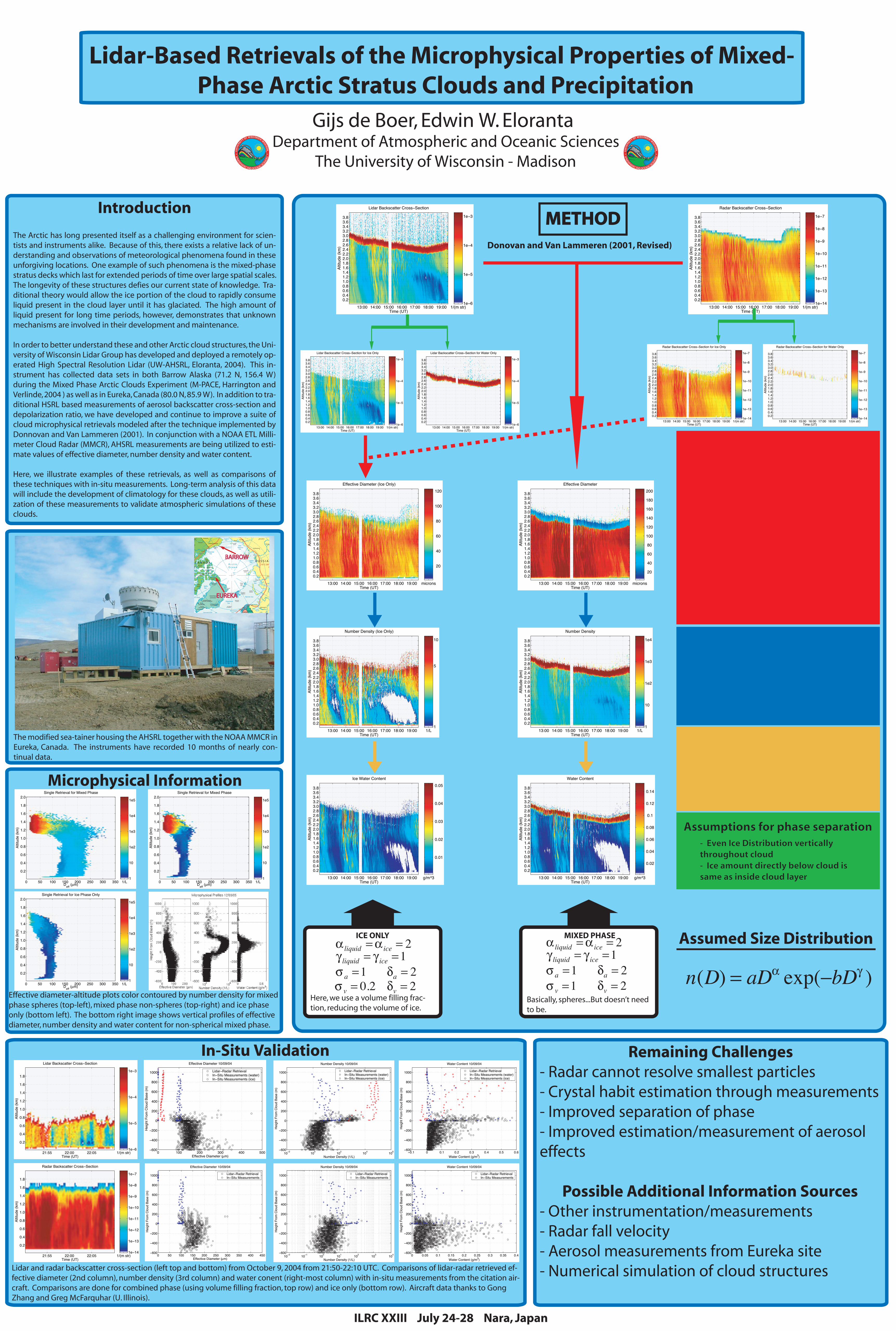
The Arctic has long presented itself as a challenging environment for scien-tists and instruments alike. Because of this, there exists a relative lack of un-derstanding and observations of meteorological phenomena found in these unforgiving locations. One example of such phenomena is the mixed-phase stratus decks which last for extended periods of time over large spatial scales. The longevity of these structures defies our current state of knowledge. Tra-ditional theory would allow the ice portion of the cloud to rapidly consume liquid present in the cloud layer until it has glaciated. The high amount of liquid present for long time periods, however, demonstrates that unknown mechanisms are involved in their development and maintenance.
In order to better understand these and other Arctic cloud structures, the Uni-versity of Wisconsin Lidar Group has developed and deployed a remotely op-erated High Spectral Resolution Lidar (UW-AHSRL, Eloranta, 2004). This in-strument has collected data sets in both Barrow Alaska (71.2 N, 156.4 W) during the Mixed Phase Arctic Clouds Experiment (M-PACE, Harrington and Verlinde, 2004 ) as well as in Eureka, Canada (80.0 N, 85.9 W). In addition to tra-ditional HSRL based measurements of aerosol backscatter cross-section and depolarization ratio, we have developed and continue to improve a suite of cloud microphysical retrievals modeled after the technique implemented by Donnovan and Van Lammeren (2001). In conjunction with a NOAA ETL Milli-meter Cloud Radar (MMCR), AHSRL measurements are being utilized to esti-mate values of effective diameter, number density and water content.
Here, we illustrate examples of these retrievals, as well as comparisons of these techniques with in-situ measurements. Long-term analysis of this data will include the development of climatology for these clouds, as well as utili-zation of these measurements to validate atmospheric simulations of these clouds.
Lidar-Based Retrievals of the Microphysical Properties of Mixed-Phase Arctic Stratus Clouds and Precipitation
Gijs de Boer, Edwin W. ElorantaDepartment of Atmospheric and Oceanic Sciences
The University of Wisconsin - Madison
The modified sea-tainer housing the AHSRL together with the NOAA MMCR in Eureka, Canada. The instruments have recorded 10 months of nearly con-tinual data.
Sea
Kara
Bay
Bay
A r c t i c
Beaufort
Laptev
Barents Sea
Greenland
Baffin
Hudson
Sea
Sea
Sea
Sea ofOkhotsk
Lake
Lake
Great Bear
Great Slave
SeaBaltic
Black Sea
Sea
BeringStrait
Chukchi
average minimumextent of sea ice
neLa
amyloK
nadlA
yuyliV
nokuY
aneL
reviR
yesineY
Lake
LakeLadoga
Onega
aglo
V
viR renekcaMeiz
NorthSea
East Siberian
N o r t h P a c i f i c
LakeAthabasca
O c e a n
Bering Sea
O c e a n
Denmark Strait
Davis Strait
N o r t h A t l a n t i c O c e a n
LabradorSea Norwegian
Sea
ceP aroh
'bO
'bO
hsytrI
maK
a
noD
repeinD
Sea
rumA
AlaskaGulf of
ecaeP
erv
Ri
hkuSano
Dvina
gehcyV
ad
Severnaya
R U S S I AC A N A D A
U.K.IRE.
ICELAND
NORWAY
SWEDENFINLAND
LATVIA
LITH.
BELARUS
UKRAINEPOLAND
DENMARK
GERMANY
EST.
KAZ.
JAPAN
(DENMARK)Greenland
(NORWAY)
Svalbard(NORWAY)
(NORWAY)
CHINA
UNITED STATES
FaroeIslands
Jan Mayen
RUS.
(DENMARK)
10˚C (50˚F) isotherm, July
Belfast
Dublin
Juneau
Anchorage
Dawson
Inuvik
Barrow
Provideniya Anadyr'
Cherskiy
Arkhangel'sk
St. Petersburg
Magadan
Khabarovsk
NizhniyNovgorod
Kazan'
Perm'
Whitehorse
Yellowknife
Echo Bay
Nome
BayPrudhoe
Fairbanks
Alert
Nord
Tasiilaq
Kangerlussuaq
(Ammassalik)
Okhotsk
Oymyakon
Verkhoyansk
Bjørnøya
Tiksi
Moscow
Tallinn
Vilnius
Qaanaaq(Thule)
Kaujuitoq(Resolute)
CambridgeBay
(Frobisher Bay)Iqaluit
Kangiqcliniq(Rankin Inlet)
Narsarsuaq
(Frederikshåb)
Itseqqortoormiit(Scoresbysund)
Noril'sk
Dikson
LakeWatson
HayRiver
Rostov
Volgograd
Saratov
Samara
Yakutsk
Helsinki
Oslo
Riga
Kharkiv
Kiev
Minsk
WarsawBerlin
Copenhagen
Kodiak Bethel
Valdez
Pevek
Repulse Bay
Tromsø
(Søndre Strømfjord)
Reykjavík
Nuuk(Godthåb)
Stockholm
Tórshavn
Paamiut
Longyearbyen
Murmansk
Sakhalin
administered by Russia, claimed by Japan.
K U R I L I S L A N D S
A
L E U T I A NI S L A N D S
occupied by the Soviet Union in 1945,
KamchatskiyPetropavlovsk-
IslandWrangel
NOVAYAZEMLYA
FRANZJOSEFLAND
SEVERNAYAZEMLYA
NEWSIBERIANISLANDS
EllesmereIsland
ISLANDS
QUEEN
ELIZABETH
BanksIsland
VictoriaIsland
SHETLANDISLANDS
BaffinIsland
elcriCcitcrA
3030
06
07
60
05
elcriCcitcrA
150
120
180150
120
60
NorthPole
08
90 E90 W
0
08
07
06
05
0
0
500 Kilometers
Azimuthal Equal-Area Projection
500 Miles
average temperature for the warmest month is below 10ºC.The Arctic region is often defined as that area where the
ARCTIC REGION
Scale 1:39,000,000
802916AI (R02112) 6-02
EUREKAEUREKA
BARROWBARROW
Remaining Challenges- Radar cannot resolve smallest particles- Crystal habit estimation through measurements- Improved separation of phase- Improved estimation/measurement of aerosol effects
Possible Additional Information Sources- Other instrumentation/measurements- Radar fall velocity- Aerosol measurements from Eureka site- Numerical simulation of cloud structures
ILRC XXIII July 24-28 Nara, Japan
In-Situ Validation
Time (UT)
Altit
ude
(km
)
Radar Backscatter Cross−Section
21:55 22:00 22:05
0.2
0.4
0.6
0.8
1.0
1.2
1.4
1.6
1.8
1/(m str)1e−14
1e−13
1e−12
1e−11
1e−10
1e−9
1e−8
1e−7
0 50 100 150 200 250 300 350 400 450−600
−400
−200
0
200
400
600
800
1000
Effective Diameter 10/09/04
Effective Diameter (µm)
Hei
ght F
rom
Clo
ud B
ase
(m)
Lidar−Radar RetrievalIn−Situ Measurements
10−2 10−1 100 101 102 103 104−600
−400
−200
0
200
400
600
800
1000
Number Density 10/09/04
Number Density (1/L)
Hei
ght F
rom
Clo
ud B
ase
(m)
Lidar−Radar RetrievalIn−Situ Measurements
0 0.05 0.1 0.15 0.2 0.25 0.3 0.35 0.4−600
−400
−200
0
200
400
600
800
1000
Water Content 10/09/04
Water Content (g/m3)
Hei
ght F
rom
Clo
ud B
ase
(m)
Lidar−Radar RetrievalIn−Situ Measurements
Time (UT)
Altit
ude
(km
)
Lidar Backscatter Cross−Section
21:55 22:00 22:05
0.2
0.4
0.6
0.8
1.0
1.2
1.4
1.6
1.8
1/(m str)1e−6
1e−5
1e−4
1e−3
0 100 200 300 400 500−600
−400
−200
0
200
400
600
800
1000
Effective Diameter (µm)
Hei
ght F
rom
Clo
ud B
ase
(m)
Effective Diameter 10/09/04
Lidar−Radar RetrievalIn−Situ Measurements (water)In−Situ Measurements (ice)
10−2 100 102 104 106−600
−400
−200
0
200
400
600
800
1000
Number Density 10/09/04
Number Density (1/L)
Hei
ght F
rom
Clo
ud B
ase
(m)
Lidar−Radar RetrievalIn−Situ Measurements (water)In−Situ Measurements (ice)
−0.1 0 0.1 0.2 0.3 0.4 0.5 0.6−600
−400
−200
0
200
400
600
800
1000
Water Content 10/09/04
Water Content (g/m3)
Hei
ght F
rom
Clo
ud B
ase
(m)
Lidar−Radar RetrievalIn−Situ Measurements (water)In−Situ Measurements (ice)
Lidar and radar backscatter cross-section (left top and bottom) from October 9, 2004 from 21:50-22:10 UTC. Comparisons of lidar-radar retrieved ef-fective diameter (2nd column), number density (3rd column) and water conent (right-most column) with in-situ measurements from the citation air-craft. Comparisons are done for combined phase (using volume filling fraction, top row) and ice only (bottom row). Aircraft data thanks to Gong Zhang and Greg McFarquhar (U. Illinois).
Microphysical Information
Deff (µm)
Altit
ude
(km
)
Single Retrieval for Ice Phase Only
0 50 100 150 200 250 300 350
0.2
0.4
0.6
0.8
1.0
1.2
1.4
1.6
1.8
2.0
1/L1
10
1e2
1e3
1e4
1e5
Deff (µm)
Altit
ude
(km
)
Single Retrieval for Mixed Phase
0 50 100 150 200 250 300 350
0.2
0.4
0.6
0.8
1.0
1.2
1.4
1.6
1.8
2.0
1/L1
10
1e2
1e3
1e4
1e5
Deff (µm)
Altit
ude
(km
)
Single Retrieval for Mixed Phase
0 50 100 150 200 250 300 350
0.2
0.4
0.6
0.8
1.0
1.2
1.4
1.6
1.8
2.0
1/L1
10
1e2
1e3
1e4
1e5
Effective diameter-altitude plots color contoured by number density for mixed phase spheres (top-left), mixed phase non-spheres (top-right) and ice phase only (bottom left). The bottom right image shows vertical profiles of effective diameter, number density and water content for non-spherical mixed phase.
Basically, spheres...But doesn’t need to be.
Here, we use a volume filling frac-tion, reducing the volume of ice.


![2 Z Q arXiv:1712.07902v1 [math.CA] 21 Dec 2017 · juj ebN: 1.4. Theorem 1.1 follows from Theorems (A) and (B). Assume that jujis bounded by 1 on (1 ") portion of Z2 and "is small](https://static.fdocument.org/doc/165x107/5e408e3d2cfe7038a85ea52e/2-z-q-arxiv171207902v1-mathca-21-dec-2017-juj-ebn-14-theorem-11-follows.jpg)

![· Web viewfollowed by reduced risk of disease deterioration [11–13]. However, only . a small portion of. HBeAg-negative patients achieve sustained response when treated with](https://static.fdocument.org/doc/165x107/5eae10bc3ad54c1225494ffa/web-view-followed-by-reduced-risk-of-disease-deterioration-11a13-however-only.jpg)