MODIS Atmospheres webinar series #3 - NASA Aerosol Optical Depth (AOD): total column optical...
29
MODIS Atmospheres webinar series #3: Collection 6 ‘e-Deep Blue’ aerosol products Andrew M. Sayer, N. Christina Hsu (PI), Corey Bettenhausen, Nick Carletta, Jaehwa Lee, Colin Seftor, Jeremy Warner Past team members: Ritesh Gautam, Jingfeng Huang, Myeong-Jae Jeong, Becky Limbacher, Clare Salustro With thanks to many others: MODIS Characterization Support Team, MODIS Atmospheres Science Team, AERONET group Climate & Radiation Laboratory, NASA Goddard Space Flight Center [email protected] 1 Images from NASA Earth Observatory, http://earthobservatory.nasa.gov/Features/Aerosols/
Transcript of MODIS Atmospheres webinar series #3 - NASA Aerosol Optical Depth (AOD): total column optical...
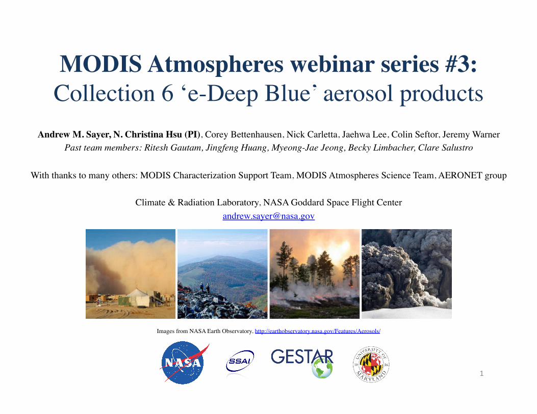
MODIS Atmospheres webinar series #3: Collection 6 ‘e-Deep Blue’ aerosol products
Andrew M. Sayer, N. Christina Hsu (PI), Corey Bettenhausen, Nick Carletta, Jaehwa Lee, Colin Seftor, Jeremy Warner Past team members: Ritesh Gautam, Jingfeng Huang, Myeong-Jae Jeong, Becky Limbacher, Clare Salustro
With thanks to many others: MODIS Characterization Support Team, MODIS Atmospheres Science Team, AERONET group
Climate & Radiation Laboratory, NASA Goddard Space Flight Center
1
Images from NASA Earth Observatory, http://earthobservatory.nasa.gov/Features/Aerosols/
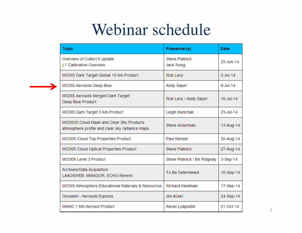
Webinar schedule
2

Overview
• Aerosol terminology • MODIS terminology • e-Deep Blue – Principles – Examples of level 2 data – New for Collection 6 – Validation
• Summary
3
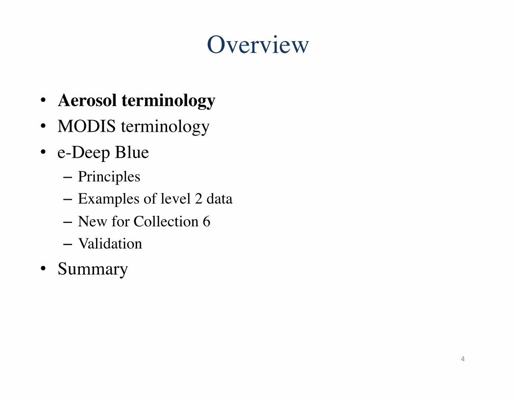
Overview
• Aerosol terminology • MODIS terminology • e-Deep Blue – Principles – Examples of level 2 data – New for Collection 6 – Validation
• Summary
4
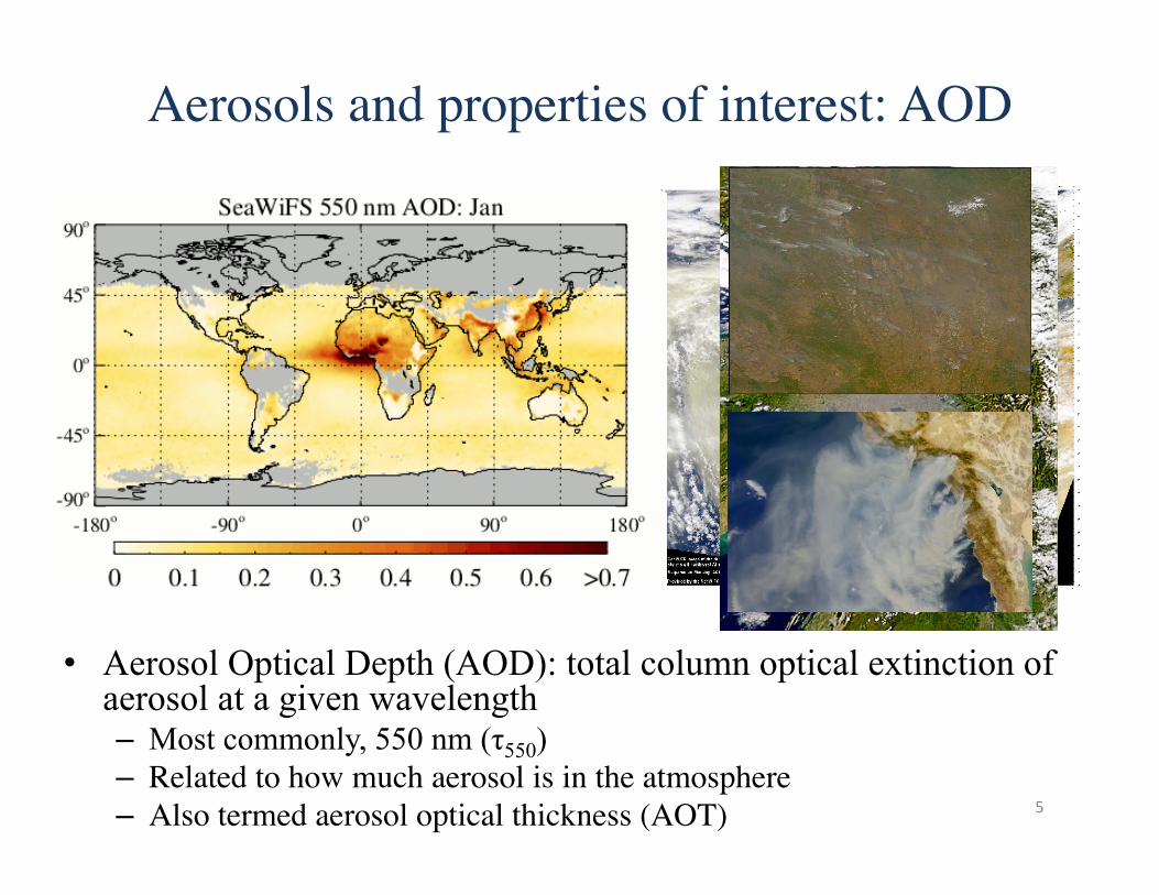
• Aerosol Optical Depth (AOD): total column optical extinction of aerosol at a given wavelength – Most commonly, 550 nm (τ550) – Related to how much aerosol is in the atmosphere – Also termed aerosol optical thickness (AOT)
Aerosols and properties of interest: AOD
5
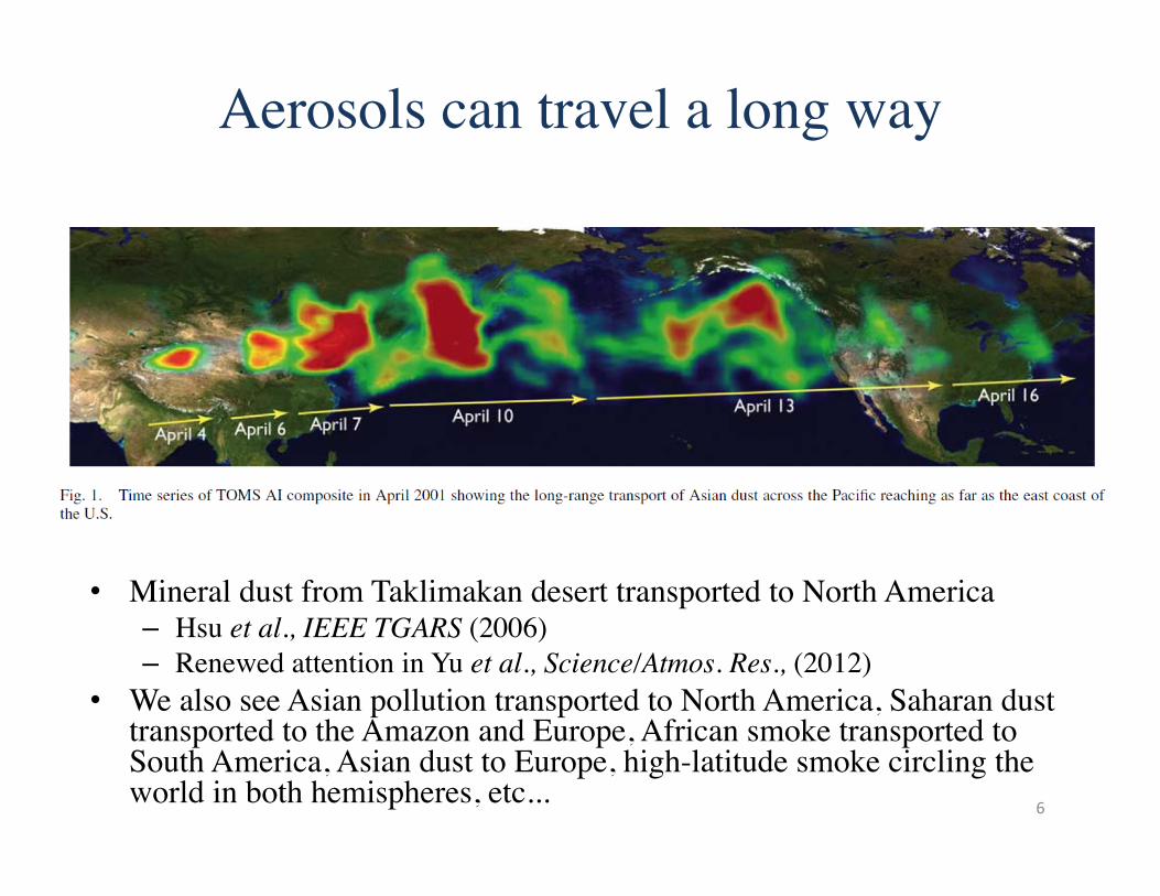
Aerosols can travel a long way
• Mineral dust from Taklimakan desert transported to North America – Hsu et al., IEEE TGARS (2006) – Renewed attention in Yu et al., Science/Atmos. Res., (2012)
• We also see Asian pollution transported to North America, Saharan dust transported to the Amazon and Europe, African smoke transported to South America, Asian dust to Europe, high-latitude smoke circling the world in both hemispheres, etc... 6
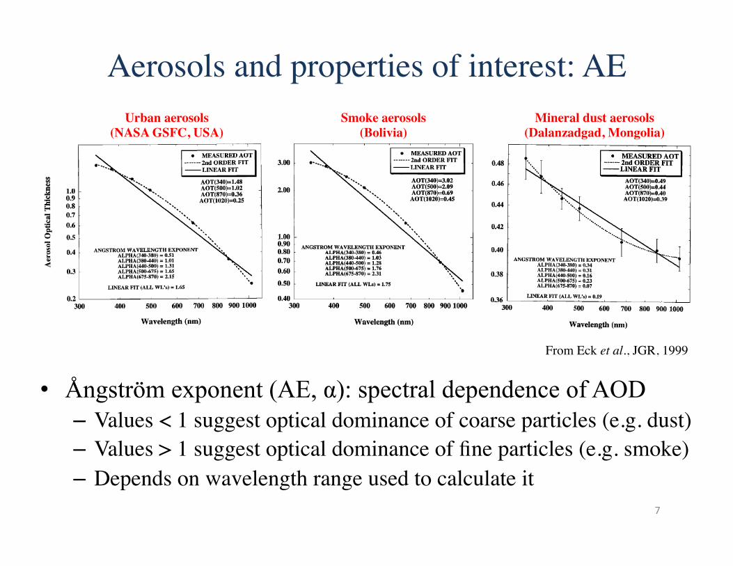
• Ångström exponent (AE, α): spectral dependence of AOD – Values < 1 suggest optical dominance of coarse particles (e.g. dust) – Values > 1 suggest optical dominance of fine particles (e.g. smoke) – Depends on wavelength range used to calculate it
Aerosols and properties of interest: AE
7
From Eck et al., JGR, 1999
Urban aerosols (NASA GSFC, USA)
Smoke aerosols (Bolivia)
Mineral dust aerosols (Dalanzadgad, Mongolia)
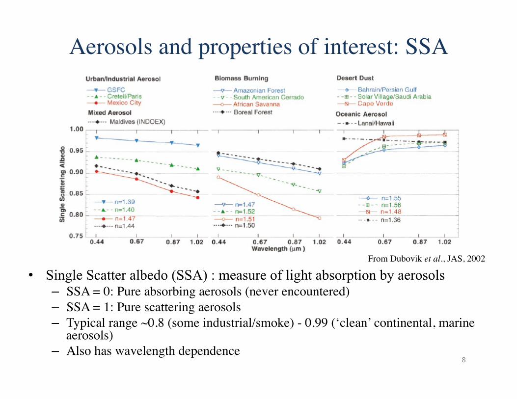
• Single Scatter albedo (SSA) : measure of light absorption by aerosols – SSA = 0: Pure absorbing aerosols (never encountered) – SSA = 1: Pure scattering aerosols – Typical range ~0.8 (some industrial/smoke) - 0.99 (‘clean’ continental, marine
aerosols) – Also has wavelength dependence
Aerosols and properties of interest: SSA
8
From Dubovik et al., JAS, 2002
Overview
• Aerosol terminology • MODIS terminology • e-Deep Blue – Principles – Examples of level 2 data – New for Collection 6 – Validation
• Summary
9
MODIS data product terminology
• Data product ‘Level’ designations relevant to the MODIS Deep Blue aerosol products – Level 1b (L1b): calibrated/geolocated instrument data – Level 2 (L2): derived geophysical retrieval data (‘pixel’ level) – Level 3 (L3): gridded data (spatiotemporal aggregation of Level 2)
• MODIS data “Collection” – A (re)processing production run with consistent baseline algorithms – Collection 5 (C5) reprocessing (2006) was the first to include Deep
Blue – Current version is Collection 6 (C6)
• Aqua level 2 processing complete • Aqua level 3 imminent • Terra level 2/3 to follow after
• This webinar is about MODIS C6 (mostly Aqua Level 2) data 10
MODIS: Moderate Resolution Imaging Spectroradiometer
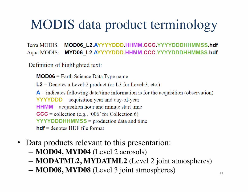
MODIS data product terminology
11
• Data products relevant to this presentation: – MOD04, MYD04 (Level 2 aerosols) – MODATML2, MYDATML2 (Level 2 joint atmospheres) – MOD08, MYD08 (Level 3 joint atmospheres)
The MODIS sensor
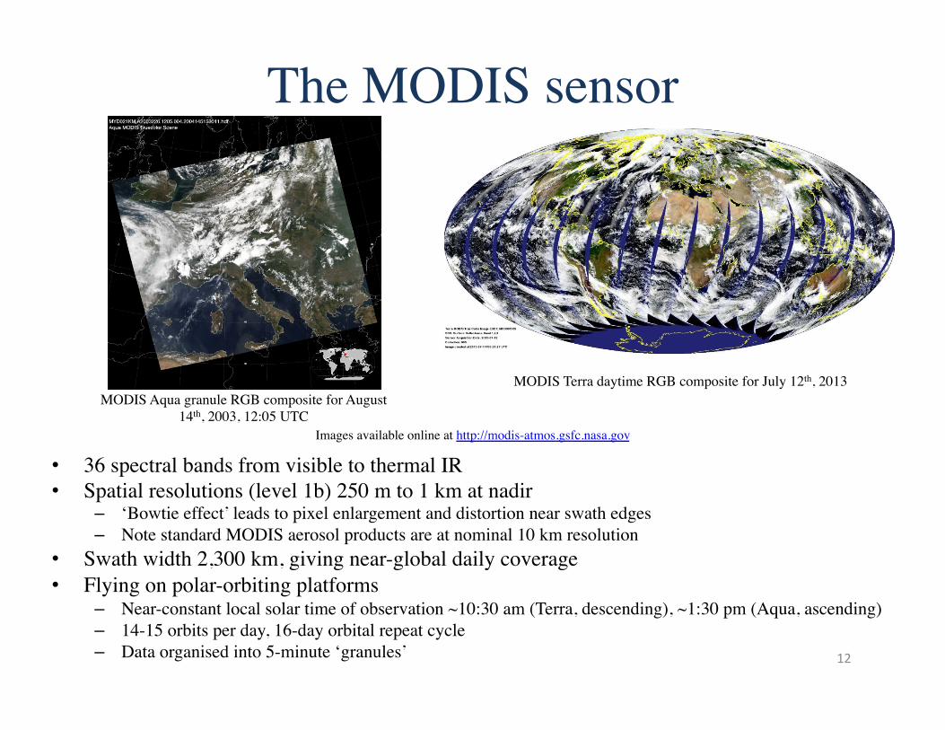
• 36 spectral bands from visible to thermal IR • Spatial resolutions (level 1b) 250 m to 1 km at nadir
– ‘Bowtie effect’ leads to pixel enlargement and distortion near swath edges – Note standard MODIS aerosol products are at nominal 10 km resolution
• Swath width 2,300 km, giving near-global daily coverage • Flying on polar-orbiting platforms
– Near-constant local solar time of observation ~10:30 am (Terra, descending), ~1:30 pm (Aqua, ascending) – 14-15 orbits per day, 16-day orbital repeat cycle – Data organised into 5-minute ‘granules’
MODIS Aqua granule RGB composite for August 14th, 2003, 12:05 UTC
12
MODIS Terra daytime RGB composite for July 12th, 2013
Images available online at http://modis-atmos.gsfc.nasa.gov
Overview
• Aerosol terminology • MODIS terminology • e-Deep Blue – Principles – Examples of level 2 data – New for Collection 6 – Validation
• Summary
13
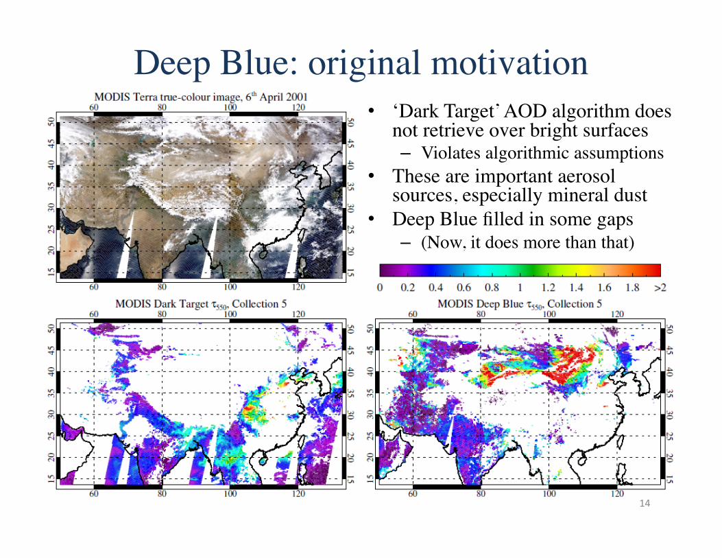
Deep Blue: original motivation • ‘Dark Target’ AOD algorithm does
not retrieve over bright surfaces – Violates algorithmic assumptions
• These are important aerosol sources, especially mineral dust
• Deep Blue filled in some gaps – (Now, it does more than that)
14
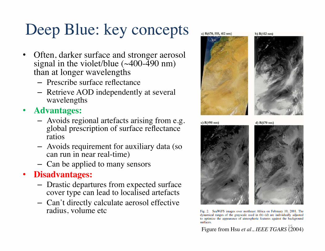
Deep Blue: key concepts • Often, darker surface and stronger aerosol
signal in the violet/blue (~400-490 nm) than at longer wavelengths – Prescribe surface reflectance – Retrieve AOD independently at several
wavelengths • Advantages:
– Avoids regional artefacts arising from e.g. global prescription of surface reflectance ratios
– Avoids requirement for auxiliary data (so can run in near real-time)
– Can be applied to many sensors • Disadvantages:
– Drastic departures from expected surface cover type can lead to localised artefacts
– Can’t directly calculate aerosol effective radius, volume etc
Figure from Hsu et al., IEEE TGARS (2004) 15
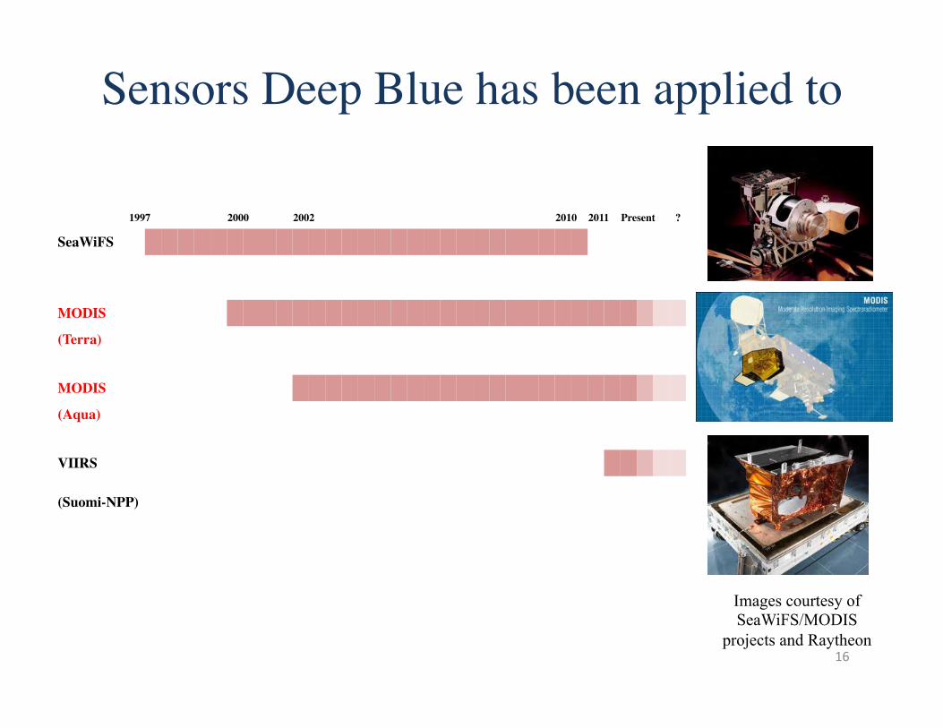
Sensors Deep Blue has been applied to
Images courtesy of SeaWiFS/MODIS
projects and Raytheon
1997 2000 2002 2010 2011 Present ?
SeaWiFS
MODIS
(Terra)
MODIS
(Aqua)
VIIRS
(Suomi-NPP)
16
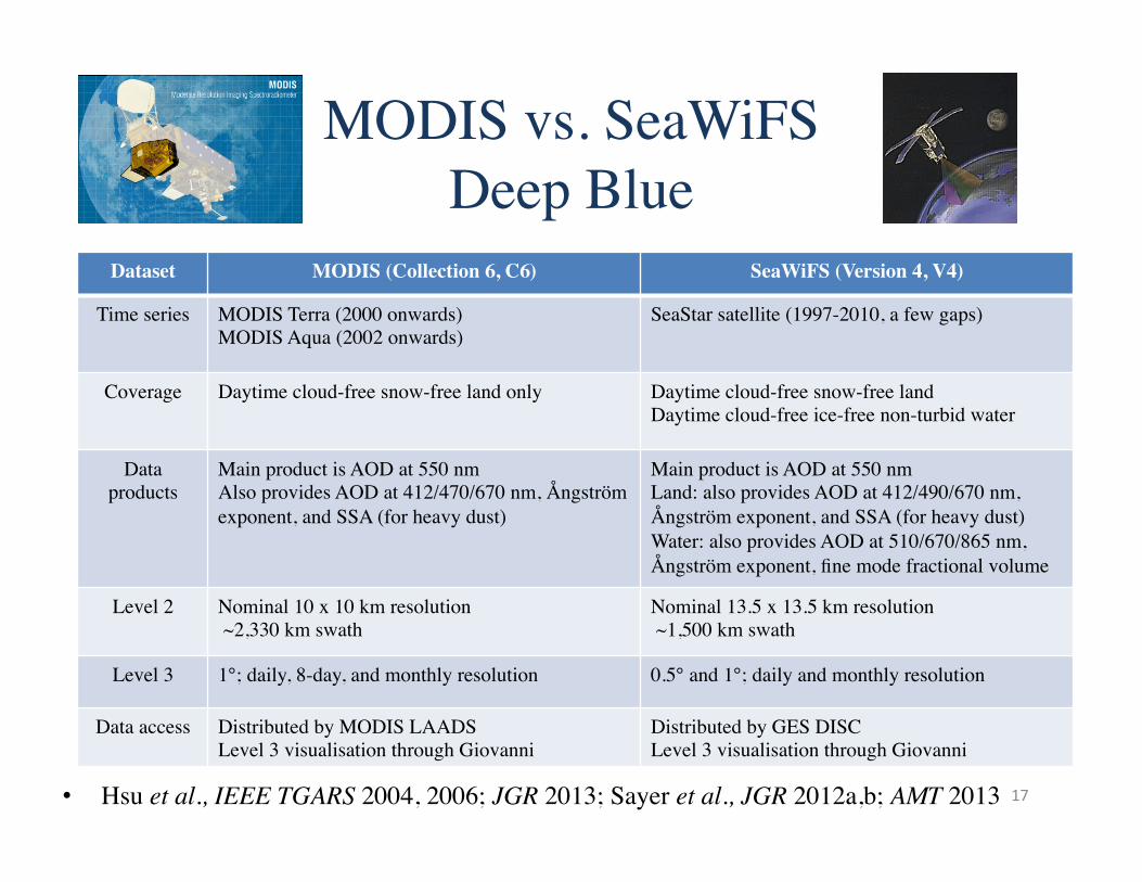
• Hsu et al., IEEE TGARS 2004, 2006; JGR 2013; Sayer et al., JGR 2012a,b; AMT 2013
MODIS vs. SeaWiFS���Deep Blue
Dataset MODIS (Collection 6, C6) SeaWiFS (Version 4, V4)
Time series MODIS Terra (2000 onwards) MODIS Aqua (2002 onwards)
SeaStar satellite (1997-2010, a few gaps)
Coverage Daytime cloud-free snow-free land only Daytime cloud-free snow-free land Daytime cloud-free ice-free non-turbid water
Data products
Main product is AOD at 550 nm Also provides AOD at 412/470/670 nm, Ångström exponent, and SSA (for heavy dust)
Main product is AOD at 550 nm Land: also provides AOD at 412/490/670 nm, Ångström exponent, and SSA (for heavy dust) Water: also provides AOD at 510/670/865 nm, Ångström exponent, fine mode fractional volume
Level 2 Nominal 10 x 10 km resolution ~2,330 km swath
Nominal 13.5 x 13.5 km resolution ~1,500 km swath
Level 3 1°; daily, 8-day, and monthly resolution 0.5° and 1°; daily and monthly resolution
Data access Distributed by MODIS LAADS Level 3 visualisation through Giovanni
Distributed by GES DISC Level 3 visualisation through Giovanni
17
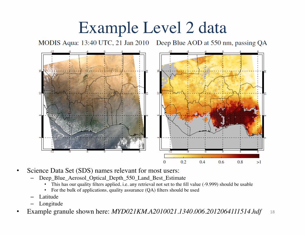
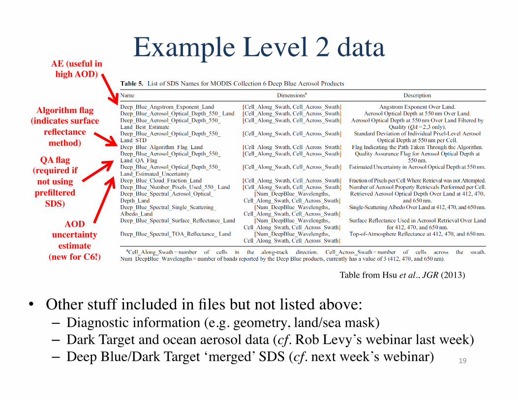
Example Level 2 data
• Science Data Set (SDS) names relevant for most users: – Deep_Blue_Aerosol_Optical_Depth_550_Land_Best_Estimate
• This has our quality filters applied, i.e. any retrieval not set to the fill value (-9.999) should be usable • For the bulk of applications, quality assurance (QA) filters should be used
– Latitude – Longitude
• Example granule shown here: MYD021KM.A2010021.1340.006.2012064111514.hdf 18
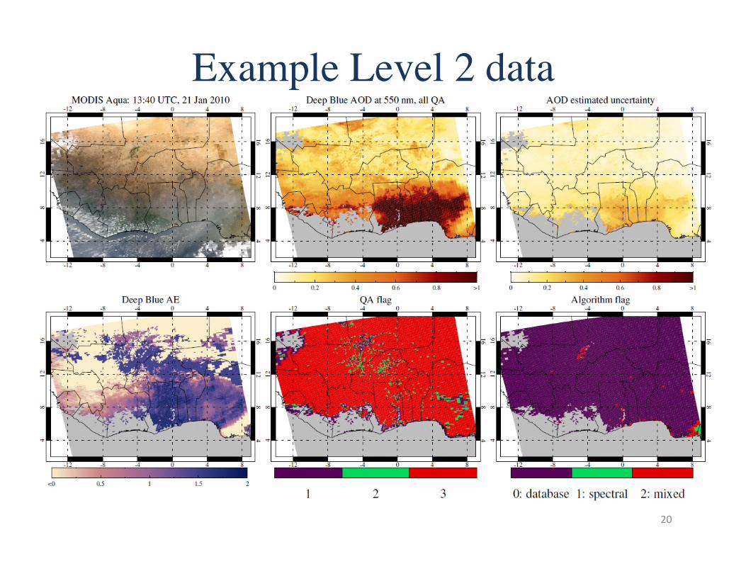
Example Level 2 data
19
• Other stuff included in files but not listed above: – Diagnostic information (e.g. geometry, land/sea mask) – Dark Target and ocean aerosol data (cf. Rob Levy’s webinar last week) – Deep Blue/Dark Target ‘merged’ SDS (cf. next week’s webinar)
Table from Hsu et al., JGR (2013)
AE (useful in high AOD)
QA flag (required if not using
prefiltered SDS)
AOD uncertainty
estimate (new for C6!)
Algorithm flag (indicates surface
reflectance method)
Example Level 2 data
20
Refinements to e-Deep Blue in MODIS Collection 6: Extended coverage to vegetated surfaces, as well as bright land
Improved surface reflectance models
Improved aerosol optical models
Improved cloud screening
Simplified quality assurance (QA) flag reading
Radiometric calibration improvements
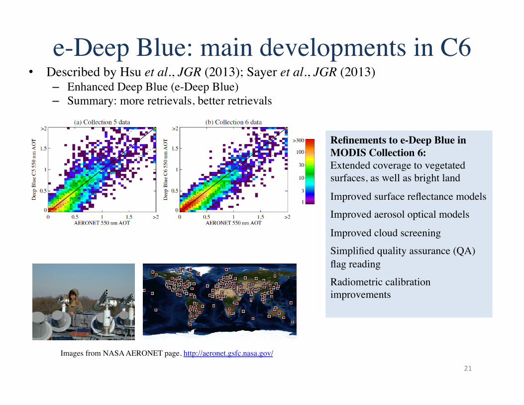
e-Deep Blue: main developments in C6
21
Images from NASA AERONET page, http://aeronet.gsfc.nasa.gov/
• Described by Hsu et al., JGR (2013); Sayer et al., JGR (2013) – Enhanced Deep Blue (e-Deep Blue) – Summary: more retrievals, better retrievals
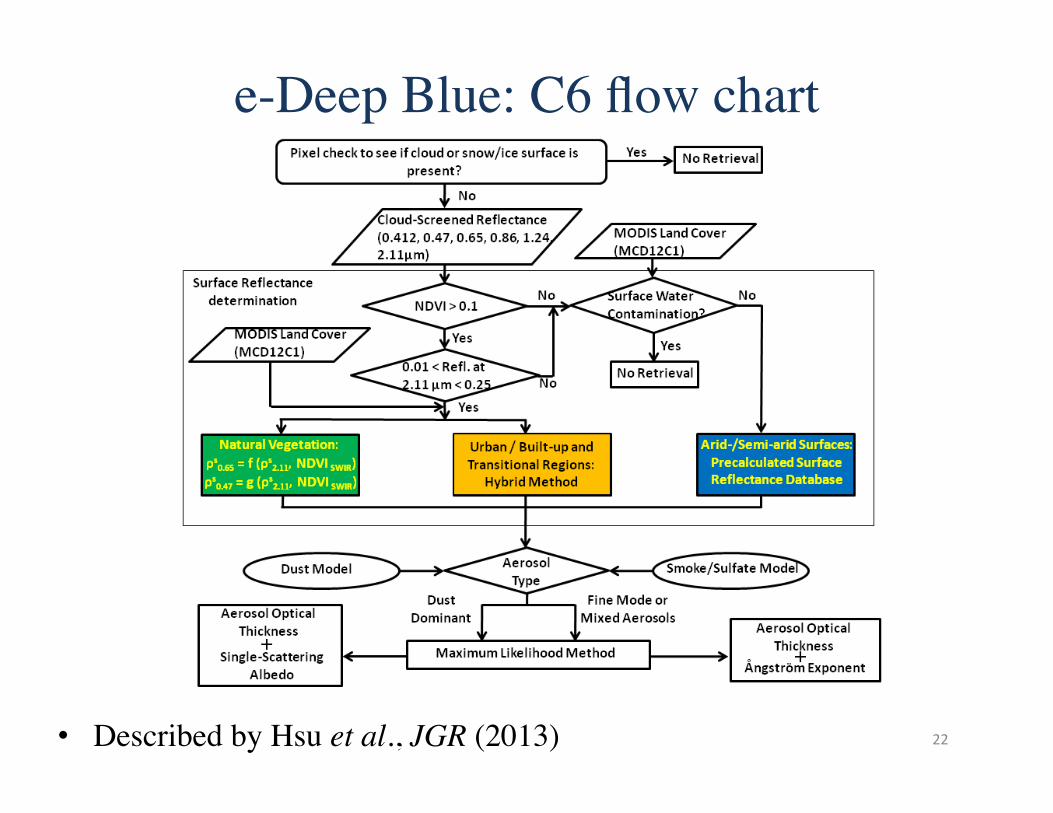
e-Deep Blue: C6 flow chart
22 • Described by Hsu et al., JGR (2013)
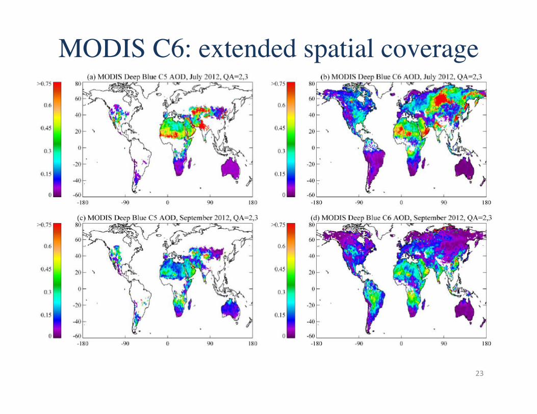
MODIS C6: extended spatial coverage
23
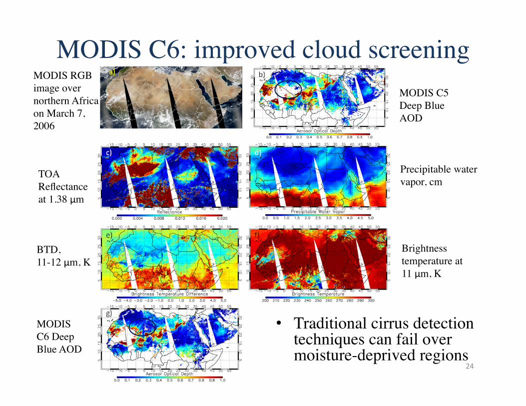
MODIS C6: improved cloud screening
• Traditional cirrus detection techniques can fail over moisture-deprived regions
MODIS RGB image over northern Africa on March 7, 2006
TOA Reflectance at 1.38 μm
Precipitable water vapor, cm
MODIS C5 Deep Blue AOD
MODIS C6 Deep Blue AOD
BTD, 11-12 μm, K
Brightness temperature at 11 μm, K
24
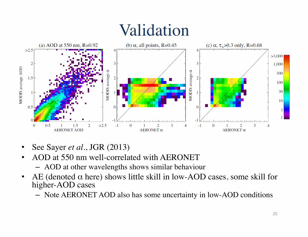
Validation
• See Sayer et al., JGR (2013) • AOD at 550 nm well-correlated with AERONET
– AOD at other wavelengths shows similar behaviour • AE (denoted α here) shows little skill in low-AOD cases, some skill for
higher-AOD cases – Note AERONET AOD also has some uncertainty in low-AOD conditions
25
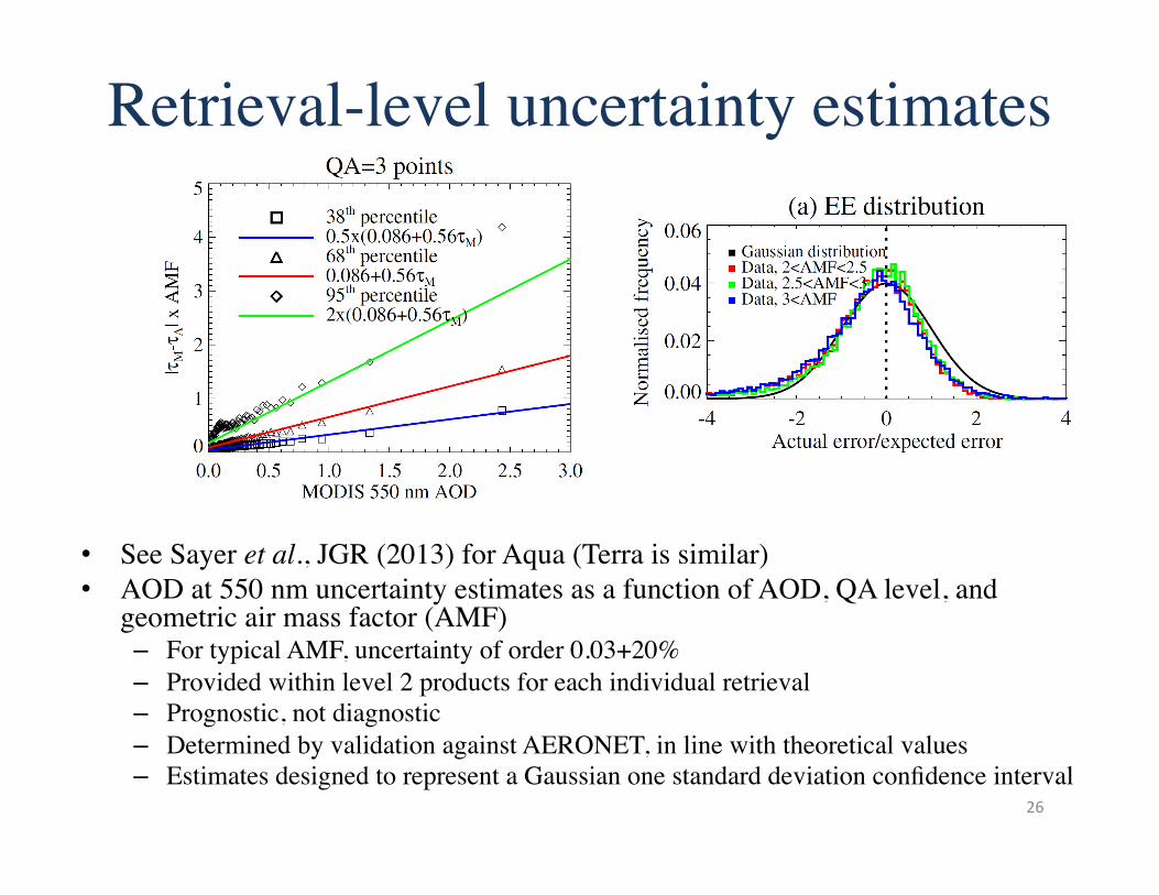
Retrieval-level uncertainty estimates
• See Sayer et al., JGR (2013) for Aqua (Terra is similar) • AOD at 550 nm uncertainty estimates as a function of AOD, QA level, and
geometric air mass factor (AMF) – For typical AMF, uncertainty of order 0.03+20% – Provided within level 2 products for each individual retrieval – Prognostic, not diagnostic – Determined by validation against AERONET, in line with theoretical values – Estimates designed to represent a Gaussian one standard deviation confidence interval
26
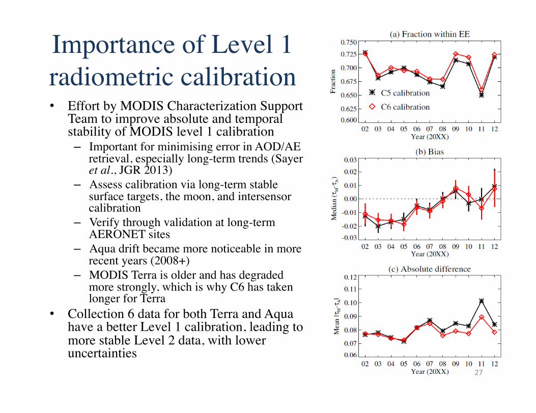
Importance of Level 1 radiometric calibration • Effort by MODIS Characterization Support
Team to improve absolute and temporal stability of MODIS level 1 calibration – Important for minimising error in AOD/AE
retrieval, especially long-term trends (Sayer et al., JGR 2013)
– Assess calibration via long-term stable surface targets, the moon, and intersensor calibration
– Verify through validation at long-term AERONET sites
– Aqua drift became more noticeable in more recent years (2008+)
– MODIS Terra is older and has degraded more strongly, which is why C6 has taken longer for Terra
• Collection 6 data for both Terra and Aqua have a better Level 1 calibration, leading to more stable Level 2 data, with lower uncertainties
27
Overview
• Aerosol terminology • MODIS terminology • e-Deep Blue – Principles – Examples of level 2 data – New for Collection 6 – Validation
• Summary
28
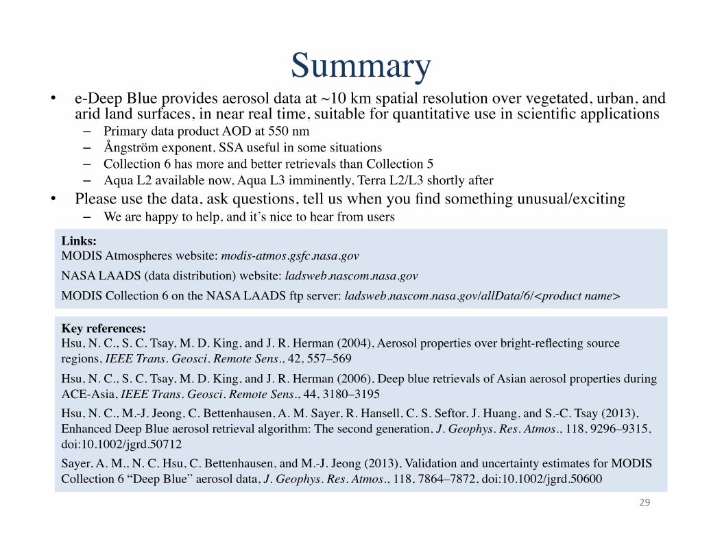
Summary • e-Deep Blue provides aerosol data at ~10 km spatial resolution over vegetated, urban, and
arid land surfaces, in near real time, suitable for quantitative use in scientific applications – Primary data product AOD at 550 nm – Ångström exponent, SSA useful in some situations – Collection 6 has more and better retrievals than Collection 5 – Aqua L2 available now, Aqua L3 imminently, Terra L2/L3 shortly after
• Please use the data, ask questions, tell us when you find something unusual/exciting – We are happy to help, and it’s nice to hear from users
29
Key references: ���Hsu, N. C., S. C. Tsay, M. D. King, and J. R. Herman (2004), Aerosol properties over bright-reflecting source regions, IEEE Trans. Geosci. Remote Sens., 42, 557–569
Hsu, N. C., S. C. Tsay, M. D. King, and J. R. Herman (2006), Deep blue retrievals of Asian aerosol properties during ACE-Asia, IEEE Trans. Geosci. Remote Sens., 44, 3180–3195
Hsu, N. C., M.-J. Jeong, C. Bettenhausen, A. M. Sayer, R. Hansell, C. S. Seftor, J. Huang, and S.-C. Tsay (2013), Enhanced Deep Blue aerosol retrieval algorithm: The second generation, J. Geophys. Res. Atmos., 118, 9296–9315, doi:10.1002/jgrd.50712
Sayer, A. M., N. C. Hsu, C. Bettenhausen, and M.-J. Jeong (2013), Validation and uncertainty estimates for MODIS Collection 6 “Deep Blue” aerosol data, J. Geophys. Res. Atmos., 118, 7864–7872, doi:10.1002/jgrd.50600
Links: MODIS Atmospheres website: modis-atmos.gsfc.nasa.gov
NASA LAADS (data distribution) website: ladsweb.nascom.nasa.gov
MODIS Collection 6 on the NASA LAADS ftp server: ladsweb.nascom.nasa.gov/allData/6/<product name>