
Πρακτικά 6ου Συνεδρίου Μάϊος 1992 Ελλ. Γεωλ. Εταιρ. Τομ...
24
Πρακτικά 6ου Συνεδρίου Μάϊος 1992 Δελτ. Ελλ. Γεωλ. Εταιρ. Τομ. XXVIII/1 σελ. 327-350 Αθήνα 1993 Bull. Geol. Soc. Greece Vol. pag. Athens SYNRIFT SEDIMENTATION DURING EXTENSIONAL FAULTING FROM MIDDLE LIAS TO MALM PERIOD AND INVERSION TECTONICS OF IONIAN BASIN IN EPIRUS (NW-GREECE). V.KARAKITSIOS ABSTRACT Ionian Basin opening and its internal differentiation is attested by lateral facies and thickness variation of the Middle Liassic to Malm formations. The begining of the synrift sequence is represented by the Siniais Limestones and their lateral equivalent of Louros limestones in which identification ahd description of Brachiopodes and Ammonites indicate a Carixian to Domerian age. The geometrical characteristics of the distentional basin are deduced from direction of Stratigraphie pinching out of the Middle Liassic to Malm formations and of synsedimentary tectonic features Cslumps, synsedimentary faults) observed in their base in the hemi-grabens. The postrift period is marked by an Early Berriasian. break-up unconformity representing the base of Uigla limestones, which their sedimentation was synchronous in the whole Ionian basin. The postrift sequence largely obscures the synrift structures and in same cases overlies directly the prerift sequence. During Alpine orogeny, collision related compressive stresses on the margin induced the reactivation of pre-existing fractures and mere responsible for the inversion tectonics that affected the Mesozoic basin. The geometric characteristics of the inverted basin depend on the lithology Cevaporites), the geometry of the extenaional structures, and the orientation of extensional faults. The Ionian zone constitutes a good example of inversion tectonics of a basin. “Department of Hist. Geology and Paleontology, University of Athens, Panepistimiopolis, 15784 ATHENS.
Transcript of Πρακτικά 6ου Συνεδρίου Μάϊος 1992 Ελλ. Γεωλ. Εταιρ. Τομ...
Πρακτικά 6ου Συνεδρίου Μάϊος 1992
Δελτ. Ε λλ . Γεωλ. Εταιρ. Τομ.XXVIII/1
σελ.327-350
Αθήνα1993
Bull. Geol. Soc. Greece Vol. pag. Athens
SYNRIFT SEDIMENTATION DURING EXTENSIONAL FAULTING FROM MIDDLE LIAS TO MALM PERIOD AND INVERSION TECTONICS OF
IONIAN BASIN IN EPIRUS (NW-GREECE).
V.KARAKITSIOS
ABSTRACT
Ionian Basin opening and its internal differentiation is attested
by lateral facies and thickness variation of the Middle Liassic to Malm
formations. The begining of the synrift sequence is represented by the
Siniais Limestones and their lateral equivalent of Louros limestones in
which identification ahd description of Brachiopodes and Ammonites
indicate a Carixian to Domerian age. The geometrical characteristics of
the distentional basin are deduced from direction of Stratigraphie
pinching out of the Middle Liassic to Malm formations and of
synsedimentary tectonic features Cslumps, synsedimentary faults)
observed in their base in the hemi-grabens. The postrift period is
marked by an Early Berriasian. break-up unconformity representing the
base of Uigla limestones, which their sedimentation was synchronous in the whole Ionian basin. The postrift sequence largely obscures the
synrift structures and in same cases overlies directly the prerift
sequence.
During Alpine orogeny, collision related compressive stresses on
the margin induced the reactivation of pre-existing fractures and mere
responsible for the inversion tectonics that affected the Mesozoic basin. The geometric characteristics of the inverted basin depend on
the lithology Cevaporites), the geometry of the extenaional structures,
and the orientation of extensional faults.
The Ionian zone constitutes a good example of inversion tectonics
of a basin.
“Department of Hist. Geology and Paleontology, University of Athens, Panepistimiopolis, 15784 ATHENS.
I. INTRODUCTION
- 3 2 3 -
The concept of inversion tectonics can be aplied at various scales
to mountain belts such as the Hellenides. At the scale of hundreds of0kilometres the whole Alpine belt can be considered to be the inverted
margin of the Tethyan ocean in response to the collision of Apulia
against Europe CGRACIANSKY & a l . 19B9) . On a smaller scale of few tens
of kilometres, the various sub-basins of the South-Tethyan margin have
been inverted to produce the main Hellenic thrust sheets or folded
zones. This occurred successively from inner (eastern) zones to
external (western) zones.
One of the most representative examples of this inversion is the
Ionian zone of external Hellenides CKARAKITSIOS 1990).
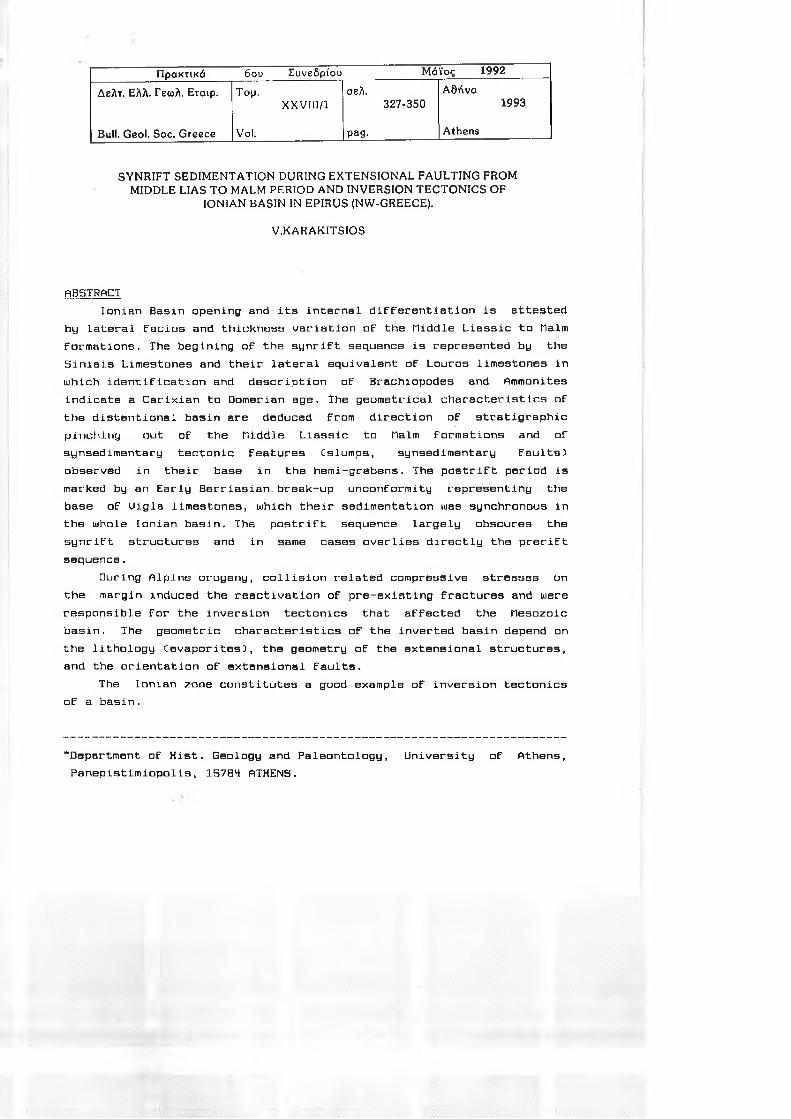
The Ionian zone of NUI-Greece CEpirus) constitutes part of the most
external zones of the Hellenides CPaxos zone, Ionian zone, Gavrovo
zo n e ; Fig . 1) .
In the Early Lias NW-Greece mas covered by a hugs carbonate
platform which, in the Middle Lias (Carixian) was intensively
block-faulted CKARAKITSIOS, 1990). This process led to the opening of
Ionian basin. Even thought the production of platform-carbonates
persisted through the whole Jurassic in the adjacent Paxos CPreapulian)
and Gavrovo zones, the Ionian basin became an area of stranger
subsidence and faulting. This paleogeographic configuration continued
with minor off-and onlap movements along the basin margins until the
Late Eocene times, when orogenic movements and flysch sedimentation set
in. In the Gavrovo and in the Ionian zones, the main orogenic movements
took place at the end of the Burdigalian, in the Paxos and Apulian
zones during the PIio-Pleistocene CIGRS-IFP, 1966; ΒΙΖΟΝ, 1967).
The present study will show that:
compressive stresses during Alpine orogeny induced the reactivation
of pre-existing fractures and were responsible for the inversion tectonics that affected the Mesozoic basin;
the geometric characteristics of the inverted basin depend on the
lithology (evaporites), the geometry of the extensional structures, and
the orientation of extensional faults (in this paper, definition of
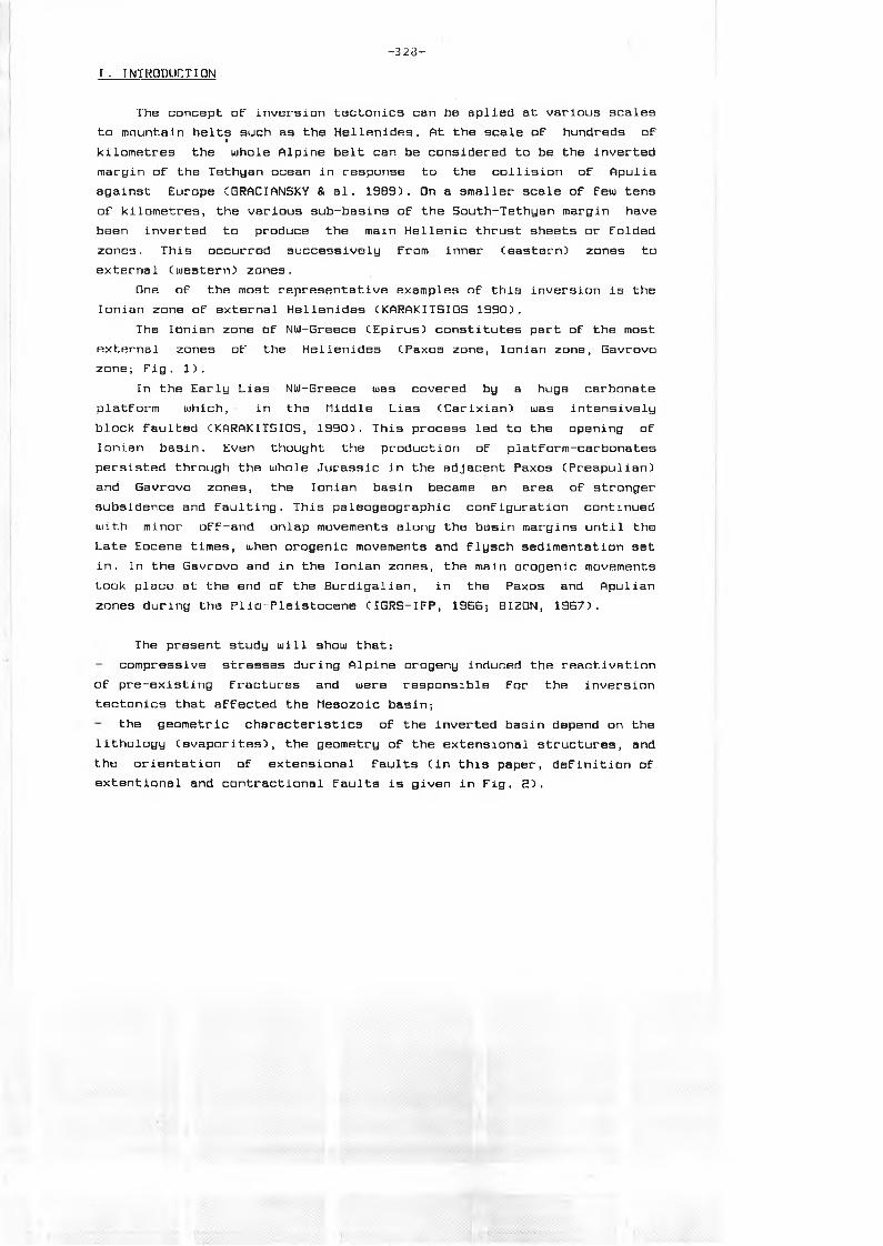
extentional and contractional faults is given in Fig. 2).
- 3 2 9 -
Fig. 2. Definition of ft, extensional and B, contractional faults (by HILLlftHS I al. 19B9)
-VErFig. la. Sructural oap of Western continental Greece (by FLEURY 1980):PA: Preapulian (Paxos) zone; 1: Ionian zone; BT: Gavrovo - Tripolitza zone; PO: Pindos - Olonos zone; P: Parnasse zone; Zi: inner zones; d: unconfornable post - tectonic fornations.
Fig. lb. Representative stratigraphical column of Ionian zone:T: Triassic; L (Li,L<a,Ls): Lias (Early, Hiddle, Upper); Js: Upper Jurassic; Ci: Lower Cretaceous, Cs: Upper Cretaceous; P: Paleocene; Es:Upper Eocene; QhLower Qigocene.
4fc x lem .io n n l ( ; it i l l Maikfr< bed is lo w e re d li r lo w re g io n a l tn HW yu d I win bo on e x ten de d O m iss io n ol s tra t ig ra p h y
C o n tra c tio n I an ti M arke» be d Mi c lu v a lu d a tm ve re g io n a l in HW an d has sh o rte n e d R e p e titio n o f s tra tig ra p h y
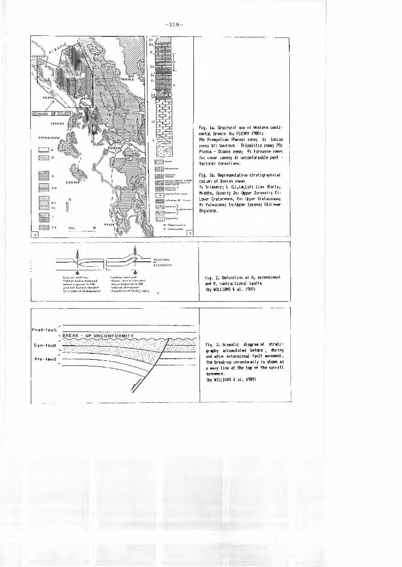
Fig. 3. Sceaatic diagram of stratigraphy accusulated before , during and after extensional fault eovesent. The break-up unconforoity is shown as a navy line at the top of the synrift sequence.(by WILLIAMS 4 al. 1989)
SP o s t - f a u l t
's/
Syn-faultVs
P r e - f a u l t
II. GEOMETRY OF SYNRIFT SEQUENCES DEPOSITED DURING EXTENSIONAL FAULTING
FROM UPPER LIAS TO MALM PERIOD.
Stratigraphy built up on extensional basins, in its simplest form,
may exhibit three distinct sequences CUJILLIAMS & a l ., 19B9), (Fig. 3):
1- a prerift sequence is deposited prior to any extensional fault
movement;
Ξ- a synrift sequence is deposited during extensional faulting. Marked
Stratigraphie thickness changes from fault footuiall to hanging utall are
indicative of growth faulting;
3- a postrift sequence is deposited after the cessation of extensional
faulting. The postrift sequence may be deposited after a period of
non-deposition and/or erosion marked by a break-up unconformity which
may remove part of the synrift sequence.
In the Ionian zone CKARAKITSIOS, 1990):
- the prerift sequence is represented by the Pantokrator limestones
CLower Lias: AUBOUIN, 1959; IGRS-IFP, 1966; KARAKITSIOS, 1990). These
shallow water limestones overlie Early to Middle Triassic evaporites
CPOMONI- PAPAIOANNOU & TSAILA-MONOPOLIS, 1983; DRAGASTAN & al,, 1985)
through Foustapidlma limestones of Ladinian-Rhetian age CRENZ, 1955;
DRAGASTAN a a l ., 19B5; KARAKITSIOS & TSAILA-MONOPOLIS, 1990);
the beginning of synrift sequence which is being represented by the
Siniais limestones and their lateral equivalent of Louros limestones
CKARAKITSIOS a TSAILA-MONOPOLIS, 1988) in which identification and
description of the Foraminifera, Brachiopods and Ammonites indicate a
Carixian to Domerian age CKARAKITSIOS, 1990). These formations
correspond to the general deepening of Ionian area (formation of Ionian
basin), which was followed by the internal synrift differentiation of
Ionian basin marked from smaller paleogeographic units as is recorded
in the prismatic synsedimentary wedges of Upper Lias to Malm
formations. In fact, CKARAKITSIOS, 1988-1991) lateral facies and
thickness variation of the Middle Lias to Malm formations CFig.
4,5 a ,5 b ,6,7,8) and directions of synsedimentary tectonic features Cslumps, synsedimentary faults) indicate that deposition was
structurally controlled by the distentional tectonic phase associated
with the latest opening of the Tethyan Ocean CBERNOULLI a RENZ, 1970;
- 3 3 0 -
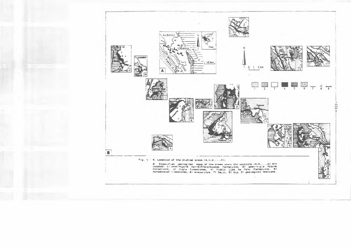
Fig. 4 - ft: Location of the studied areas Ca,b,c n);B: S i m p l i f i e d g e o l o g i c a l m a p s of the ar e a s wh e r e the s e c t i o n s Cft,B,...,Z} arelocated: 1) p o s t - A l p i n e n o n - d i f f e r e n t i a t e d formations, Ξ) p o s t - U i g l a A l p i n e form a t i o n s , 3) Ui g l a lime s t o n e s , Ό n i d d l e L i a s to H a l m f o r m a t i o n s , 55 P a n t o k r a t o r limestones, 6) e v a p o r i t e s , 71 fault, 85 dip, 9J g e o l o g i c a l sections.
I 50 km
WNW AnoKouklessi
ESE
IUJ
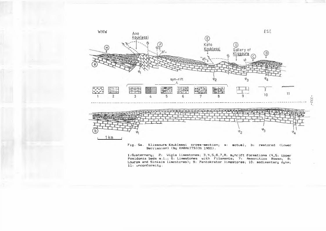
Fig. 5a. Klissoura-Kouklessi cross-section; a: actual, b: restored CLouerBerriasian) Cby KARAKITSIOS 1990 5.
1:Quaternary; 2: Uigla limestones; 3,4,5,6,7,B: synrift formations C4,5: UpperPosidonia beds s .1.; B: Limestones with Filaments; 7: Ammonitico Rosso; B:Louros and Siniais limestones); 9: Pantokrator limestones; 10: sedimentary dyke; 11: unconformity.
SOUTH OF ANO EAST OF ΑΝΟ KATO GALLERY OF SOUTH OF EAST OFKOUKLESSI KOUKLESSI KOUKLESSI KL1SSOURA KLISSOURA KLISSOURA VATHY
~rg~
BE
LF 1-20 m
L 0
Pantokrator pocket with AR
hg: hard ground
I iH E
AR
-slumps
-PL
©
®
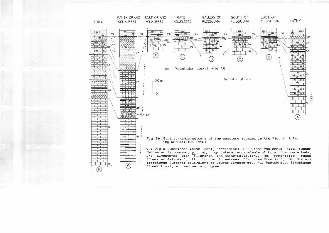
Fig. 5b. Stratigraphie columns of the sections located in the Fig. Cby KARAKITSIOS 1990):
4: & 5 ε ,
UL: Uigla limestones Chase: Early Berriasian), UP: Upper Posidonia beds CUpper Callovian-Tithonian), pi, ml, hg: lateral equivalents of Upper Posidonia beds, L F : Limestones with Filaments CBajocian-Callovian), AR: Ammonitico rossoCToarcian-Aalenian), LL: Louros limestones (Carixian-Oomerian), SL: Siniaislimestones Clateral equivalent of Louros limestones), PL: Pantokrator limestones CLomer Lias), sd: sedimentary dykes.
- 3 3 4 -
K AI TS AKATO
PANGRATES HIONISTRA PAL1AMBELA
VL
UP
I f i E '^ I W1 γ Τ LF
HZ
μ . I I &- S L '
I I
Θ
<2ZZ> I
■X f Z X
0
- 3 . 5 Km
PL
Ε Θ
VL
LF
SL
' Θ
l p;
UP
SL
Θ
PETOUSS1 ΚΑΚΟ S0UL1
VL VL
UP
LL ?
PL
SL ΘΘ
[ -2 0 m
- 0
—3 Km —
(S T Β»
«S T B »: same tilted block
« ST B »
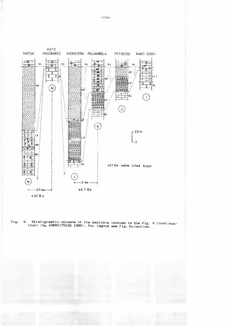
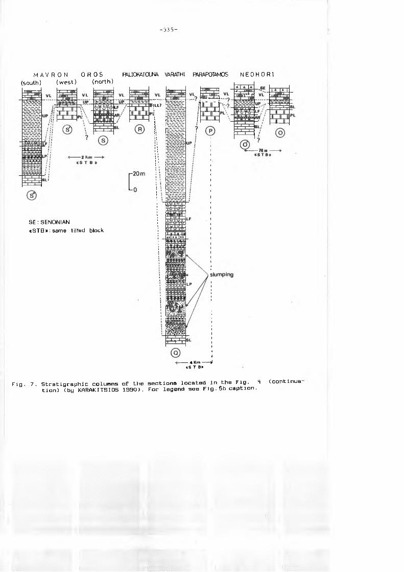
Fig. B. Stratigraphie columns of the sections located in the Ficj. 4 (continuation) (by KARAKITSIOS 1930). For legend see Fig. 5b caption.
- 3 3 5 -
M A V R O N O R O S (south) (w e s t) (n o rth )
PALlOKATOim VARATHI FÄRAPCPM05 N E 0 H 0 R 1
SE : SENONIAN <iSTB»:sam e tilted block
■ 4 Kit» ^«S T Β»
Fig. 7. Stratigraphie columns of the sections located in the Fig. H Ccontinua tion) Cby KARAKITSIOS 1990). For legend see F i g . 5b caption.
- 3 3 6 -
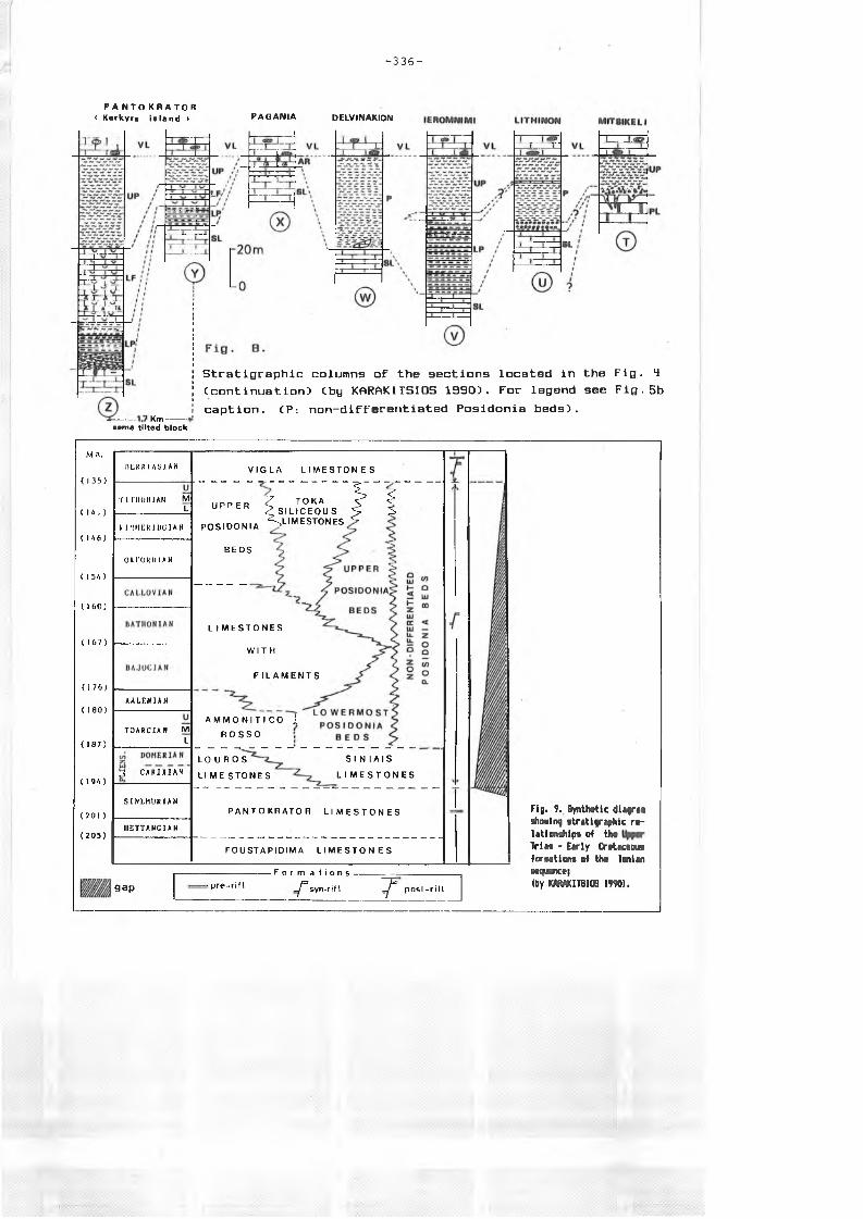
P A Ν Τ Ο Κ R A T O R < Korkyro island > PAGANIA DELVlPäAKIOrO
1 K m ----oomo tlltsd blocl:
Stratigraphie columns oF the sections located in the Fig. 4 (continuation) (by KARAKITSIOS 1990). For legend see Fig. 5b caption. (P: non-diFFerentiated Posidonia beds).
Ma.
(135)
( 141 )
(146)
(154)
( J 6 0 )
(167)
(176)
(180)
(1Ö7)
(194)
( 2 0 1 )
( 205)
R t K R l A S l A N
Τ Ι Ί Ί Ι 0 Μ 1 Λ Ν M L
K I M M K R I I X J I A N
OX r O K U I A N
AALENIAN
T 0 A R C I A N M L
3 CARIXIAN
SINEHUR1AN
I I E T T A N C I A N
V I G L A L I M E S T O N H S
U P P E R
P O S I D O N I A
BE DS
^ T O K A ^ S
^ S I L I C E O U S S- 5-' S L I M E S T O N E S ^
L I M E S T O N E S
W I T H
F I L A M E N T S
A M M O N I T I C O i
R O S S O
L O U R O S
LI ME S T O N E S
SI N I A I S
L I M E S T O N E S
P A N T O K R A T O R L I M E S T O N E S
FO U ST A PI DI M A L I M E S T O N E S
gap : p r e - r i l t
- F o r m a lions- -̂ syn-rif I 7 p o s l - r i f t
Fig. 9. SynMratic di£®rea Bhoaing atratigrsphic r&- latieaäiifra o? tbs Tries - Early CrotecGEua foroaUons a f tha Ie iisnESqiETOQ)
(by K «Ü T 8 I0 8 i9?9).
KARAKITSIOS, 1390). The Early Lias shallow marine platform was affected
by intense block-faulting of listric geometry which was recorded
CKARAKITSIOS 1990, 1991) by differential subsidence uiithin each small
paleogeographic unit. Prismatic synsedimentary wedges of the Middle
Lias to Malm formations in the small paleogeographic units vary in
thickness along an EUI direction and underline the facies distribution
Chiatus are located on top of tilted blocks and Ammonitico rosso or
’’Lowermost Posidonia beds” formation are located in the deeper part of
the half-grabens). Influence of the Ionian zone evaporitic substratum
halokinesis in the synrift mechanism, is not only theoretically
possible CKARAKITSIOS, 19S8) but it is also attested by the presense of
gypsum elements observed in the conglomerate of the base of the
"Lowermost Posidonia beds" in the Lithino section CKARAKITSIOS 1990, p.
150-154). The stratigraphic relationships of the Upper Trias to Early
Cretaceous formations of Ionian sequence are given in the synthetic
diagram of Fig. 9. The geometric characteristics of the beginning of
the synrift intrabasinal differentiation into tilted blocks is
presented in the paleogeographic and stuctural map of Upper Liassic
CFig. 10) recostructed from the 1ithostratigraphic analysis of the
Jurassic formations all over the Ionian zone in Epirus CKARAKITSIOS, 1990). In this map, one can observe:
a- the areas of comlete, thick Upper Lias to Malm formations Czone ”1”)
and the Ammonitico rosso and "Lowermost Posidonia beds” distribution in their bottom;
b- the areas where unconformity and hiatus are presented in these formations -submarine highs (seamounts) or rarely emerged areas- (zone
"II”);
c- cartographical direction of statigraphic pinching out of the Upper Lias to Malm formations (organized in sedimentary wedges on each tilted block);
d- the regional dip of various tilted blocks;
e- the major synsedimentary listric faults of Upper Liassic times;
f- the average direction of slumps axis and minor normal synsedimentary
faults observed in the base of the Upper Lias to Malm formations in the deeper part of the tilted blocks;
- the postrift period is marked by an Early Berriasian (KARAKITSIOS,
1990; KARAKITSIOS & K0LETTI, 1992) break-up unconformity representing
the base of Uigla limestones, which their sedimentation was synchronous
- 3 3 9 -
in the whole Ionian basin. The postrift sequence CUigla limestones and
the overlain Alpine formations) largely obscures the synrift structures
and in some cases overlies directly the prerift sequence CFig. 5a,5b,
7,0). The deposits of Uigla limestones do not correspond to a sea-level
rise due to eustatic reasons, but to a general sinking of the entire
basin CKARAKITSIOS 1990; KARAKITSIOS & KOLETTI, 1992). The permanence
of differential subsidence during the deposition of the Uigla
limestones Cas the strong variation in thickness of this formation
shows: IGRS-IFP, 1966) is probably due CKARAKITSIOS, 19ΘΒ-1991) to the
continuation of halocinetic movements of the Ionian zone evaporitic
substratum.
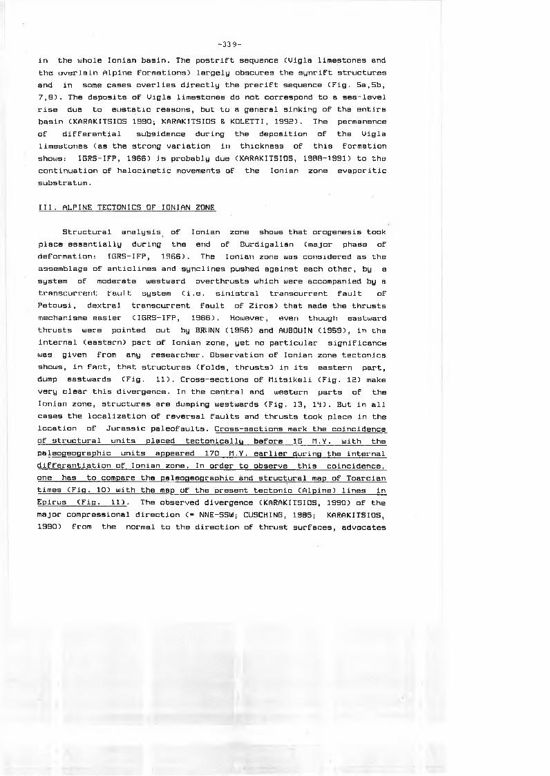
III. ALPINE TECTONICS OF IONIAN ZONE
Structural analysis of Ionian zone shows that orogenesis took
place essentially during the end of Burdigalian Cmajor phase of
deformation: IGRS-IFP, 1966) . The Ionian zone was considered as the
assemblage of anticlines and synclines pushed against each other, by a
system of moderate westward overthrusts which were accompanied by a
transcurrent fault system Ci.e. sinistral transcurrent fault of
Petousi, dextral transcurrent fault of Ziros) that made the thrusts
mechanisme easier CIGRS-IFP, 1966). However, even though eastward
thrusts were pointed out by BRUNN C1956) and AUBOUIN C1959), in the
internal Ceastern) part of Ionian zone, yet no particular significance
was given from any researcher. Observation of Ionian zone tectonics
shows, in fact, that structures Cfolds, thrusts) in its eastern part,
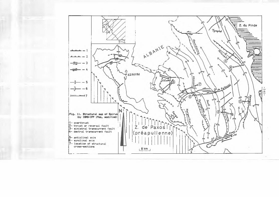
dump eastwards CFig. 11). Cross-sections of Mitsikeli CFig. 12) make
very clear this divergence. In the central and western parts of the
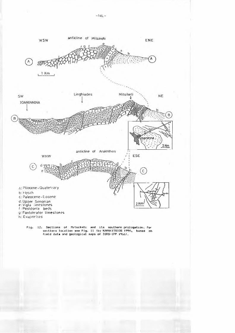
Ionian zone, structures are dumping westwards CFig. 13, 14). But in all
cases the localization of reversal faults and thrusts took place in the
location of Jurassic paleofaults. Cross-sections mark the coincidence
of structural units placed tectonically before 15 M.Y. with the
paleogeographic units appeared 170 Π.Υ. earlier during the internal
differantlation of Ionian zone. In order to observe this coincidence,
one has to compare the paleogeographic and structural map of Toarclan
times CFig. 10) with the map of the present tectonic CAlpine) lines in
Epirus CFig. 1 1). The observed divergence CKARAKITSIOS, 1990) of the
major compressional direction C= NNE-SSUJ; CUSCHING, 19B5; KARAKITSIOS,
1990) from the normal to the direction of thrust surfaces, advocates
- 3 4 1 -
W SW
Θ
anticline of Mitsikeli E N E
W NW
©
a: P lio cene-Q uatern ary
b: Flyschc : Paleocene - Eocened:U pper Senonian e:V ig la lim estones f : Posidonia beds g : Pantokrator lim es ton es h: E v a p o rite s
Fig. 12. Sections of Mitsikeli and its southern prologation. For sections location see Fig. 11 (by KARftKITSIOS 1990, based on field data and geological maps of IGRS-IFP 1966).
La
• ο © ο ο ο Ο ο
|eo« ο I
R = Lfa- La = 2. 85 km R % = — — ili- = 20.72 % Lb
5a 5b 5c 7
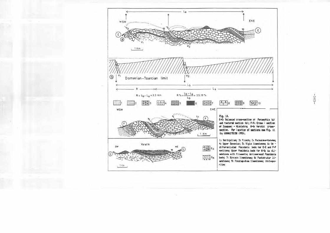
Fig. 13. Balanced cross-asction o-f Derviziana-Klissoura (a) and restored section (b). For section location see Fig. 11 (by KARAKITSIOS 1990).
1: Quaternary; 2: F'aleocene-Eocene; 3: Upper Senonian; 4Posidonia beds (a), and equivalent -facies (b,c,d); 6Ammonitico rosso; 8: Siniais and Louros limestones; 9Foustapidima limestones; 11: evaporites.
Vigla limestones; 5; Upper limestones with -filaments; 7: Pantokrator limestones; 10:
ΕΝΕ
>r~>: eb
Fig. 14.E-Es IslaiLcd e-esa-OEztira of Par«»ythi* to esd raisrei osrtio « 5 F-fa ßrsac - esties ®5 ta^cni - {taisiraji S-@s ¥cro4fji 0resa- ccjtim. fe· teafciea of Gcstissa ccs Fig. 11 % K£OT!S!ßs 1990».
1: Eurdigalian; 2: Flysch; 3: Paleocsne-Eocett; 4: Upper Estonian; 5s Vigla li*estorc?5; 6s tin - differsjitiatod Positaia fcsds for E-E end F-F sGction5j Upper Positaia fesfc for Θ-S; 6a sLi- esGtonas Mite Filassnts; 6b:Laacs-Eost Praittenia beds; 7: Siniais licastcmss; Ss PanteixatB· li- csstmes; 9: FraistcpidieQ liaesttsies; lOsEva^a- rites

- 3 4 4 -
that thrusts as break surfaces, should not owe their origin in this
phase of deformation. These surfaces are more probably considered to be
pre-existing, for instance ancient listric faults due to the
distensional phase of Jurassic times which were reactivated in the new
compressional status, principally as thrusts with horizontal component
CFig. 11). Wowever, the double divergence of Ionian structure -westward
in the western and central parts and eastward in the eastern part
respectively- is certainly due to the structures inherited from the
distentional Jurassic pha^se which was translated from a certain
symmetry of Ionian basin as far as this is concerned from the tilting
of external CApulian side) and internal blocks CGavrovo side) during the same period of time CFig. 10). As far as the transcurrent fault
system of Epirus is concerned, the observation, of the sinistral
transcurrent fault of Petousi CKARAKITSIOS, 1990; Fig. 11) showed that
this system is later than the folds and the direction of compression
related to its activation is considered to be different Ci.e. NE-SU to
E—Ul) from that associated with the thrusts CNNE-SSltf) . The
interpretation of seismic cross-sections involves CKARAKITSIOS, 1990) a westward growth of horizontal displacement of the Ionian zone, with a
more expressed diapirism in the same direction. This is in accordance
with the balanced cross-sections provided from the field data Csee
evaluated amount of shortening from East to West, Fig. 13,14).
Consequently, a moderate decollement in the sub-surface evaporites,
especially in the external domain of Ionian zone, is certain; however
it is out of question to assimilate this decollement with that
suggested by GUZZETTA C19B1) in Epirus and BP C1971), JENKINS C1972)
and SOREL & CUSCHING C190S) in Akarnania.
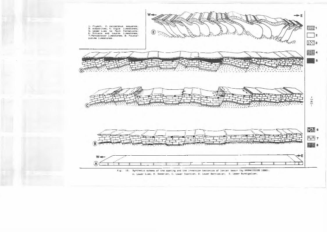
IU. PALEOGEOGRAPHIC AND STRUCTURAL · EVOLUTION OF IONIAN BAG IN IN THE
ALPINE CONTEXT: AN ILLUSTRATION OF THE OPENING AND THE INUERSION
TECTONICS OF IONIAN BASIN CFIG. 15)
During the Upper Triassic the Foustapidima limestones mark the end
of favorable conditions for sulfates precipitation and the installation
of a more frankly marin sedimentation in the Ionian area CKARAKITSIOS,
1990). During the the Lower Liassic CFig. 15 A) a huge carbonate
platform bordering the Southern Tethyan Ocean is established over the
whole western Greece. This platform was characterized CBERNOULLI &
RENZ, 1970; KARAKITSI0S, 1990) by a strong subsidence which was
- 3 4 6 -
balanced by intensive carbonate sedimentation in a very shallow-water
sedimentary environment (emersion limit) that accumulates a carbonate
sequence CPantokrator limestones) of more than a thousand metres
thickness CIGRS-IFP, 1966; BP, 1971).
During Carixian times CKARAKITSIOS 1990), the initial shallow
carbonate platform began to break up. The first general deepening of
the Ionian area is testified from the Siniais and the Louroe limestones
deposits. The distension that involves this deepening uias probably
expressed by border faults uihich separated the Ionian basin from the
adjacent Paxos Cin the Ulest) and Gavrovo Cin the East) zones where the
production of platform-carbonates persisted through the whole Jurassic.
Louros limestones and their lateral equivalent of 9inials limestones,
correspond, then, to the first synrift sediments of Ionian series. The
Siniais facies occupied the axial part of Ionian basin whilst Louros
facies its bordering areas CFig. 15 B) ■
From Domerian to Toarcian limit, the continuation of distension
was accompanied by intense block-faulting which led to the internal
differentiation of Ionian basin CFig. 15 C) . Listric faults associated
with this phase caused the separation of the initial basin into a
number of small Cin general between 5 to 10 kilometres across)
paleogeographic units Con each tilted block) which was subjected to
differential subsidence. Thus, in the deeper part of the half-grabens,
Ammonitico rosso or "Lowermost Posidonia beds” formation were
deposited. These deposits were also accompanied by products of
submarine or aerial erosion derived from the top of the same tilted
block and especially from the top of the adjacent tilted block Cbreccia
with big elements or big blocks detached from the fault scarps, fallen
in the depressed part of the tilted block; i.e. South Kouklesi and
□elvinaki sections respectively). On the top of the tilted blocks,
hiatus, hard-grounds and sendimentary dykes are located. These tops
constitute either submarine high or Crarely) an emerged relief Cthe
case of emerged relief is attested by the presence of Coniferous
branches observed in the base of ’’Lowermost Posidonia beds” ; i.e.
Hlonistra section. KARAKITSIOS 1990, p. 1ΞΕ and 125). Gypsum injections
into the fault surfaces are possible if fault throws are strong Ci.e.
Lithino section). These conditions persisted with minor modifications
until Upper Jurassic whereas the sedimentation was being more and more
calm with the progressive filling up of the depressed parts by the Upper Liassic to Malm formations.
- 3 4 7 -
□uring the Early Berrlssian CFig. 15 D) a general sinking of the
entire basin is attested by the onset of the deposition of pelagic Uigla limestones in the whole Ionian zone. Apart From halocinetic
movements which probably provoked the variation in thickness of Uigla
limestones, the same conditions persisted until the Late Eocene times,
when flysch sedimentation set in. Sedimentation remains always pelagic
accompanied by clastic deposits derived from the adjacent Gavrovo and
Apulian platforms
At the end of the Burdigalian CFig. 15 E) the major compressional phase that affected the Ionian zone reactivates by reversing, to a
great extent, the sense of motion of the pre-existing Jurassic axtensional fault system. Listric faults were transformed in reversal
faults, thrusts; or transcurrent faults. This phenomenon was
facilitated by diapiric movements through the tectonic surfaces of the
svaporitic base of the Ionian zone. A moderate decollement in the
sub-surface evaporite3, especially in the external domain of Ionian
zone, is very probable; however, field data and available seismic
cross-sections exclude a major decollement as that suggested by
BUZZETTA C19B1) in Epirus and BP C1971), JENKINS C197E) and SOREL &
CUSCHING C19BS) in Akarnania. The symmetry of the Ionian basin
associated with the distentional phase of Jurassic times is manifested
in the double divergence of its compressional structure Cwestward in
the West and eastward in the E a st).
U.CONCLUSIONS
The Ionian zone constitutes a good example of inversion tectonics
of a basin. Its paleogeographic and structural evolution is sufficiently comparable to Umbria-Marche zone of North Appenines
CBARCHI & al., 19B9; ALUAREZ, 19B9; CECCA & al, , 1990).
The organic matter accumulated in the Lowermost Posidonia beds of
Ionian zone CJENKYNS, 19B8; BAUDIN & LACHKAR, 1990) during the Late
Lias, * "is· directly related to the geometry of the opening of Ionian
Basin that caused a particular type of some restricted sub-basins which
geometry favored their stagnation and consequently the localy euxinic
conditions of the sea floor waters. In these areas, the Jurassic black
shales CPosidonia beds) were deposited especially during the Upper
Liassic times CLowermost Posidonia beds).
The influence of evaporitic substratum halokinesis in the synrift
- 3 4 3 -
mechanism, which has been observed in the Ionian Basin, since the Upper
Liassic times, has as result areas where the evaporitic substratum
thickness was minimum Careas with Ammonitico Rosso or Lowermost
Posidonia beds) and areas where its thickness was maximum (areas with
hiatus of Middle Lias to Malm Formations). As a consequence there may
be an oil interest in the pre-evaporitic Ionian substratum research
which is unknown in the exposure as well as in the bore hole.
Finally, the opening and the inversion tectonics of Ionian Basin influence, at the same time, the source rocks and the probable traps of
Ionian zone.
REFERENCES
ALUAREZ W . C19B9). Evolution of the Monte Nerone seamount in the
Umbria-Marche Apennines: Ξ. Tectonic control of the seamount-basin
transition. Boll. S o c . Geol. It., 10B, pp. 23-39.
AUBOUIN J. C1959) . Contribution ä l ’ätude geologique de la Grece
septentrionale: les confins de l ’Epire et de la Thessalie. Ann.
geol. Pays Hell., 1, IX, pp. 1-4B3.
BARCHI M., LAUECCHIA G. & MINELLI G. C19B9). Sezioni geologiche
bilanciate attraverso il sistema a pieghe Umbro-Marchlgiano: 2
la sezione Scheggia-Serra S. Abbondio. Boll. Soc. Geol. It., 10Θ, p p . 69-Θ1 .
BERNOULLI D. & RENZ D. (1970). Jurassic Carbonate Facies and New
Ammonite Faunas from Western Greece. Eclogae Geol. Helv., B3, 2, pp. 573-607.
ΒΙΖΟΝ G. (1967). Contribution a la connaissance des foraminiferes
planctoniques d ’Epire et des lies ioniennes (Grece occidentale)
depuis le Paleogene superieur Jusqu’au Pliocfene. Soc. Editions Technip, Paris.
BP (19B1). The geological results of petroleum exploration in western Greece. Inst. geol. subs. Res., Athens, 10, 73 p .
BRUNN J.H. (1956). Contribution ä l ’6tude geologique du Pinde
septentrional et d ’une partie de la Macedoine occidentale. Ann. geol. Pays Hell., 1, UII, pp. 1-35B.
CECCA F., CRESTA S., PALLINI G. & SANTANT0NI0 Μ. (1900). II Giurassico
di Monte Nerone (Appennini marchigiano, Italia Centrale):
biostratigrafia, 1itostratigrafia ed evoluzlone paleogeografica.
- 3 4 9 -
Atti II C o n v . Ins F.E.A. Pergola, 87, Pallini et alii cur., pp.
63-139.
CUSCHINB h. C1985). Evolution structurale de la marge nord-ouest
hellenique dans l ’lle de Levkas et ses environs CGrfece
nord-occidentale). T h . D o c t . 3e cycle, Univ. Drsay, 297 p.
DRAGASTAN PAPANIKOS 0. S PAPANIKOS P. C1905). Foraminiferes, Algues
et microproblernatica du Trias de Messopotamos, Epire CGrece continentale). Rev. hicropaleont., 57, 4, pp. 244-248.
GRACIANSKY P.C., DAROEAU G., LEH0INE M. & TRICART P. C19B9). The inverted margin of the French Alps and foreland basin inversion.
Cooper h.A. & Williams G.D. Ceds), Inversion Tectonics, G e o l . S o c .
Sp. Publ., 44, pp. B7-104.
GUZZETA G. C1982). Thin-skinned Style of Deformation in Epirus. HEAT
Proceedings, Athens, I, pp. 151-175.
IGRS-IFP C1966). Etude geologique de l ’Epire CGrece nord-occidentale).
Ed. Technip, Paris, 30B p.
JENKINS D.A.L. C1972). Structural development of Western Breece. AAPB
Bull., 56, 1, pp. 128-149.
KARAKITSIOS 0. C1988). Sur la differenciation de la zone ionienne en
Epire CBrece nord-occidentale) . Proceedings of the 3th Congress of
Geol. Soc. of Greece, Athens, May 19BB. Bull, Geol. Soc. Greece,
XX / 5 , pp. 181-196.
KARAKITSIOS U. C1989).Donnees nouvelles sur la Stratigraphie des formations jurassiques de la serie ionienne CEpire, Grece) .
Consequences paleogeographiques et tectoniques. Proceedings of the
4th Congress of B e o l . Soc. of Breece, Athens, hay läBB. Bull.
Beol. Soc. Breece, XXI11/2, pp. 59-74.
KARAKITSIOS U. C1990). Chronologie et geometrie de l ’ouverture d ’un
bassin et de son inversion tectonique: le bassin ionien CEpire,
B receD. T h . Doct. Univ. Paris U I . CMem. Sc. Terre Univ. Curie
Paris, 91-4), 310 p.
KARAKITSIOS U. C1991). Etude des paleofailles Jurassiques de la zone
ionienne CEpire, BreceD. Proceedings of the 5th Congress,
Thessaloniki, hay 1990. Bull. Geol. Soc. Greece, XXU/1, pp.
307-318.
KARAKITSIOS U. & TSAILA-I10N0P0LIS S. C19B8). Donnees nouvelles sur
les niveaux superieurs CLias inferieur-moyen) des Calcaires de
Pantokrator Czone ionienne moyenne, Epire, Grece continentale).
Description des Calcaires de Louros. Rev. hicropaleont., 31, 1,
- 3 5 0 -
pp. 49-55.
KARAKITSIOS U. & TSAILA-MONOPOLIS S. C1990). Donnees nouvelles sur les
niveaux inferieurs CTrias superieur) da la serie calcaira ionienne
an Epira CGrece continentals). Consequences stratigraphiques. Rev. Palöobiologie, 9, 1, pp. 139-147.
KARAKITSIOS U. & KOLETTI L. C199E) . Critical revision of the Age of the
basal Uigla Limestones CIonian Zone, Western Greece), based on
Nannoplankton and Calpionellids, ujith paleogeographic
consequences. 4th INA Conference proceedings, Prague, September 1991 Cin press).
SOREL D. & CUSHING M . C1982). Mise en evidence d ’un charriage de
couvertura dans la zone ionienne en Grece occidentale: la nappe
d ’Akarnanie-Levkas. C. R. Acad. Sc., Paris, S94, II, pp. 675-678.
WILLIAMS G.O., POWELL C.M. S COOPER M . A . C1989). Geometry and
kinematics of inversion tectonics. Cooper M.A. & Williams G.D.
Cads), Inversion Tectonics, G e o l . S o c . S p . P u b l ., 44, pp. 3-15.


![με αφορμή [κι όχι αιτία] τις εκλογές|ακα-εαακ|μάϊος 2011](https://static.fdocument.org/doc/165x107/568bdb071a28ab2034acf8d3/-568bdb071a28ab2034acf8d3.jpg)