RUMAH GADANG IN THE CORE OF THE MINANGKABAU AREA
8
Architectural Institute of Japan NII-Electronic Library Service Arohiteotural エnstitute of Japan F 【 カテゴ リ ー 1 】 日本 建 築 学 会 計 画 系 論 文 集 第531号 , 149 − 156 . 2000 年. 5 月 J ・ A 「chit ・ ? lann ・ En 噸 n ・ . E ” g ・ ・ 叩 , N ・・ 531 ・ 149 ’ 156 ・ ¥ ・ ¥ ・ 20°0 STUDY . ON ORIENTATION OF ‘ RUMAH GADANG ’ IN THE CORE OF THE MINANGKABAU AREA Village compositioh based on housing lay − out analysis 、 of pariangan and Baruah Bukik ミ ナ ン カ バ ウ の 居住地域 に おけ る ル マ ガ ダ ン の 方位 の 研究 バ リア ン ガ ン ζ バ コ , レ ア ブ キク で の 民 家 配置 の 分析 に 基 づ く 集 落 の 構 成原 瑾 Selma IVAKAMURA * .引 ナ カム ラ セ ル マ This paper aims to clarify th 』 subjects 6ftraditi6nal orientatio” . of 几 tmtth gaclang ( customary houses , abbr . RG } , vinage spatial f (} rmation , as 幽 we 旺as RG s重 yles in the Minangkabauheartl 母 nd , inSumatrE 」 Indonesia . Itstarts with a bibliographical reView , pOinting limitations on the picture presented by most au 山ors , espeoially concerning RG styles and itstraditional orientation . [ t shows concrete exampl6s of RG cotlected f 吟 m differentbibliographical so 丗 c , es and also fU ) m my own field work , describing main arch虻eGtural . chqra じteristics of these buildings . 羽bese examples of RG show that . styles yary even inside the same village . . ” The paper next describes and compares . main spatial characteristics oftwo ViLLages , Parianganand Baruah Bukik . giving speeia1 accent to the subject ofRG erienfatiOti and local oTu1 rules which aT : believed tO d ¢ finethis orientatiorn . It shows that oral rules of orientation of the RG vary 丘om vnlage tg village , In 重 he end , it presentS the . rcsult ofanalysis about the orien 重 ation ofRG in 30 Mim 皿 gkabau villages , Ridgepoles ofthe RG d 「 eu ・ualty p ・・ aji ・ ゆ ・a ・h ・th … φ i 脚 b ・ d … 「 i ・・ rf ・ ) . ・ pd ・・ ry ・fU・ ’ P ・i ・血 9 ’ 脱 m ・皿 蜘 ・ t ・ p ・ ・ κ 卿 ρo 鴻 :Min . angkab 硼 1 ρ r ’ e π 1 α 猷 oη 那 皰鵬 即 η6ぬ 9 呻 μ η ぬ ηe5 v9 厂 nacu ’ σ r 卿 海f ’ ectUre ・ v”lage stiucta 厂 e . ’ ミ ナ ン カ バ ウ 族 , 方 位 シ ス テ ム . ル マ ガ ダ ン . 1 . OBJECTIVES AN1)BACKGROUND OF RESEARCH : Bukit Barisa 皿 chain of mountains layS close tt ) the weStern 『 oast of Sumatra , Lndonesia . The equatbT Iine crosses themiddle of theisland , and my research area issituated in West Sumatra ProVince , in the heartland of thc Minangkabau ethnica ] gμ 〕up lgcated in the Barisan mountains ( f 設}m E100 ° 20 ’ t °Eloe ° 45 ’ 1 °ngitude 岬 佇゜m SOpO5 ’ t° Sl ° OO ’ lltitt ’de ) ・ ” Minangkabau ” is the name Qf bOth the ethnical gtoup and the geographical area they , occupy . The 川 毋α面 g ψ ( custornary houses ) are 血em ・st imp ・r t mdit 孟 ・mal byildingS f ・r them ・ They were used f ・r domestic and ceremonial purposes inthe pas ち and . many ntmah gadOng ( abbr . RG ) can still bef {) und in the heartla 皿d n σwadays . This paper aims to clarify abOut trzditional orientation of RG , viHagc spatial { fomlation , as well as about RG styles in the Minangkabau heartla 皿 d. It will start wi 廿田 bibliographica1 . reView on thesubject of orie 孕 吟 tionand . ‘ ・ ty1 ・s ’ ・ fRG ・ lt ・ will ・ ・Xt p ・ e・e ・t ・・… ete ・ ・a ・tipl … fRG 肋 m di 飩 ・ent 、 villages , in different areas in . 重 he Minangl [ abau With plans and nt elevations compiled ffOm the eXiSting bibliography and alsoadding my ewn fieldworkdata ;We WM see 山at RG styles v 毋 y m village tO villEge or eve 皿 insidethe same vMage , although a domimnt Style can be de 監 erm ed fbreach village , lt . witl the 卩 prcsent 尹 critical view 斧 bOut the usual classification ofRG ‘ styles ’ discussed by most authors until 出 e present day . NeXt , i wM briefly 6xplain main spatial charac 重 eristics of 2 Villages , ・ Pariangan and Baruah Bukik , pointing5imilarities and contrastS in their spatiat organizatien . We will see that the RG ridgepOle orientation in Parianganisdifferent from that in BaruahBukik . . Villagers ’ be ] iefs on erierttation omens 』 partially explain RG ridgept }Le orientation . . Hewever , one イ ン ド ネ シ ア . ヴ ァ ナ キ ュ ラ ー 建築 . 農村稱 成 sbould be cafefUI and distinguish ’ oral s重 ated rules ’ and tfactual rules , , oncc 「 idear . and 「 practice ’ are quhe differentthingsin 山e Minangkabau culture and ds ◎ ourse ・ We will see that ora1 ’ orientation rules also va 置 y 恥 m vmag 『 tO Village . We 噛ill じonclude that all authors who spoke about ・ a singl と general coordinate rule for atl 血 e Minangkabail probab 【 y oonsidered oraI data cQllected fU ) m fie 【 d . work ofasing 【 e vmage ( or few villages ) , and that none of 出 ese rules can b 『 applicable b all Mina kabauvinages . This was preved after 1 qnalyzcd theRG orie 嘸 tiop in 30 villages . We wiH disgover some co on oHen 蝋 ion ch 罅 噸 cs v 組 id 國 Mll 曙 es inthe s ple , despite} al variations of oral mles of o “ entadon ・ Iwill give in the end Sbrne chronologica 【dimensions fororientation tOwards mountains under the . light of recent archaeQlogical excavations , explain brieflyhow orien 倣 ion of the RG isdeclded mwadays by , common agreement ’ and to finalize the tex ち IwiU make a summary ofthe basicconclusions ofthjs p叩 er . 2. REVtEVVOF BOOKS . 2. 1 . Concemi [且 g systems oforientation and cosmologies S・ yth … tA ・i と 坤 ・・cei・・d m ・・ y 1 ・ y ・「 d gf ・ul 噸 li ・fl ・・n 。… ffOm ・ itS pre − lndianLzed background , it Was 廿 亘 巳 n influ 巳 nced by Indiainthe beginning of the Christian era ( govemmental sphere and Hindu ・ Buddbist religien } , 1atc ゆ y Islarnor Chri5tianity , and finallyby Wes 跏 Golon 圃 on . Orientationsystems have also changed With history ( Waterson l990 : 9 牛 5 , ll2 ) . Tliere ・ are ・ tWo ・ different ・ views ・ on ・ the ・ s 呵 ect:one that rein 亅 brces ! he Hindu background in many Solitheast Asian s ial groups ( Blust 1980 ; 220 ) and ano 血er that stresses the pre − Hindu じosmological systent ( Waterson l990:94 ) . Orien 戯 ionof housesand vi1lages in Austronesian sociedesL usuaUy ・ fc ) nows a variety of coordina 艇} s according to I a夏 ge6graphic 率 GraduateStudent , Graduate School of Science and Technology , KyotG Institute of Technology 京 都 工 芸繊 維 大学大学 院工芸科学研 究 科 博士課程 一 149 一 N 工工 一 Eleotronio Library
Transcript of RUMAH GADANG IN THE CORE OF THE MINANGKABAU AREA
Architectural Institute of Japan
NII-Electronic Library Service
Arohiteotural エnstitute of JapanF
【カ テ ゴ リー1】 日本建築 学会 計画 系論文 集 第 531号 ,149−156.2000年.5 月
J・A 「chit ・?lann・En噸n・.E ”g・・叩 , N ・・531・ 149’156・¥・¥・20°0
STUDY.ON ORIENTATION OF ‘RUMAH GADANG ’
IN THE CORE OF THE MINANGKABAU AREA
Village compositioh based on housing lay−out analysis 、
of pariangan and Baruah Bukik
ミナ ン カバ ウ の 居住地域 に おけ るル マ ガダ ン の 方位 の 研究
バ リア ン ガ ン ζバ コ,レア ブ キ ク で の 民 家配 置 の 分 析 に 基 づ く集落 の 構 成 原瑾
Selma IVAKAMURA *
.引
ナカ ム ラ セ ル マ
This paper aims to clarify th』subjects 6ftraditi6nal orientatio”.of 几 tmtth gaclang(customary houses, abbr. RG }, vinage spatial f(}rmation , as
幽
we 旺as RG s重yles in the Minangkabau heartl母nd, in SumatrE」 Indonesia. It starts with a bibliographical reView , pOinting limitations on the picturepresented by most au 山ors , espeoially concerning RG styles and its traditional orientation .[t shows concrete exampl6s of RG cotlected f吟m
different bibliographical so 丗 c,es and also fU)m my own field work , describing main arch 虻eGtural .chqra じteristics of these buildings.羽beseexamples of RG show that.styles yary even inside the same village.
.”
The paper next describes and compares .main spatial characteristics oftwo ViLLages, Pariangan and Baruah Bukik. giving speeia1 accent to the
subject ofRG erienfatiOti and local oTu1 rules which aT : believed tO d¢ fine this orientatiorn . It shows that oral rules of orientation of the RG vary
丘om vnlage tg village , In 重he end , it presentS the.rcsult ofanalysis about the orien重ation ofRG in 30 Mim 皿gkabau villages, Ridgepoles ofthe
RG d「e u・ualty p・・aji・ゆ ・a・h ・th… φi脚 b ・ d … 「i・・rf・).・pd・・ry・fU・’P・i・血 9
’脱 m ・皿 蜘 ・ t・p・
・
κ卿 ρo 鴻 :Min.angkab 硼 1ρr’e π1α猷oη 那 皰鵬 即 η6ぬ9呻 μηぬ ηe5 v9 厂nacu ’σr 卿 海f’ectUre・ v”lage stiucta 厂e.
’
ミ ナ ン カ バ ウ 族 ,方 位 シ ス テ ム .ル マ ガ ダ ン .
1.OBJECTIVES AN1)BACKGROUND OF RESEARCH :
Bukit Barisa皿 chain of mountains layS close tt) the weStern 『oast of
Sumatra, Lndonesia. The equatbT Iine crosses the middle of the island, and
my research area is situated in West Sumatra ProVince, in the heartland of
thc Minangkabau ethnica ]gμ〕up lgcated in the Barisan mountains (f設}m
E100°20’t°Eloe°45’1°ngitude 岬 佇゜m SOpO5’t°
Sl°OO’
lltitt’de)・
”Minangkabau
”is the name Qf bOth the ethnical gtoup and the
geographical area they,occupy . The 川 毋α面gψ (custornary houses)are
血em ・st imp・r t mdit 孟・mal byildingS f・r them・They were used f・r
domestic and ceremonial purposes in the pasちand . many ntmah gadOng
(abbr. RG )can still be f{)und in the heartla皿d nσwadays .
This paper aims to clarify abOut trzditional orientation of RG , viHagc
spatial{fomlation, as well as about RG styles in the Minangkabau heartla皿 d.
It will start wi廿田 bibliographica1.reView on the subject of orie孕吟tion and.
‘・ty1・s
’・fRG ・lt・will ・ ・Xt p・e・e ・ t・・… ete ・・a ・tipl… fRG 肋 m di飩 ・ent 、
villages , in different areas in .重he Minangl[abau With plans and nt
elevations compiled ffOm the eXiSting bibliography and also adding my ewn
fieldwork data; We WM see 山 at RG styles v毋y m village tO villEge or
eve 皿 inside the same vMage , although a domimnt Style can be de監erm ed
fbr each village, lt.witl the卩 prcsent尹 critical view 斧bOut the usual
classification ofRG‘styles
’discussed by most authors until 出e present day.
NeXt, i wM briefly 6xplain main spatial charac 重eristics of 2 Villages,・Pariangan and Baruah Bukik, pointing 5imilarities and contrastS in their
spatiat organizatien . We will see that the RG ridgepOle orientation in
Pariangan is different from that in Baruah Bukik..Villagers’be]iefs on
erierttation omens』partially explain RG ridgept}Le orientation..Hewever, one
イ ン ド ネ シ ア .ヴ ァ ナ キ ュラー
建 築 .農 村 稱 成
sbould be cafefUI and distinguish’oral s重ated rules
’and
tfactual rules
,, oncc「idear
.and
「practice
’are quhe different things in山 e Minangkabau culture
and ds◎ourse ・We will see that ora1’orientation rules also va 置y 恥 m vmag 『
tO Village. We 噛illじ onclude that all authors who spoke about・a singl と
general coordinate rule for atl 血e Minangkabail probab【y oonsidered oraI
data cQllected fU)m fie【d.work ofasing 【e vmage (or few villages), and that
none of 出ese rules can b『applicable b all Mina kabau vinages . This was
preved after 1 qnalyzcd the RG orie嘸 tiop in 30 villages. We wiH disgover
some co on oHen 蝋 ion ch 罅 噸 cs v 組id國 Mll 曙 es in the s ple,
despite} al variations of oral mles of o “entadon ・Iwill give in the end
Sbrne chronologica 【dimensions for orientation tOwards mountains under the.light of recent archaeQlogical excavations , explain briefly how orien 倣 ion
of the RG is declded mwadays by ,common agreement’and to finalize the
texちIwiU make a summary ofthe basic conclusions ofthjs p叩 er.
2.REVtEVVOF BOOKS.
2.1.Concemi [且g systems oforientation and cosmologies
S・yth… t A ・iと坤 ・・cei・・d m ・・y 1・y・「d gf・ul噸 l i・fl・・n。… ffOm・itS
pre−lndianLzed background, it Was廿亘巳n influ巳nced by India in the beginning
of the Christian era (govemmental sphere and Hindu・Buddbist religien },
1atcゆ y Islarn or Chri5tianity, and finally by Wes 跏 Golon 圃 on .
Orientation systems have also changed With history(Waterson l990:9牛
5,ll2). Tliere・are ・tWo・different・views ・on ・the・s呵 ect:one that rein亅brces!he
Hindu background in many Solitheast Asian s ial groups(Blust 1980;220)
and ano 血 er that stresses the pre−Hindu じosmological systent (Waterson
l990:94). Orien戯 ion of houses and vi1lages in Austronesian sociedesL
usuaUy ・fc)nows a variety of coordina 艇}s according to I a夏 ge6graphic
率Graduate Student, Graduate School of Science and Technology , KyotG Institute of
Technology京都 工 芸繊 維 大学大学院 工 芸 科 学 研 究科 博 士 課 程
一 149一
N 工工一Eleotronio Library
Architectural Institute of Japan
NII-Electronic Library Service
ArchitecturalInstitute of Japan
features or eardinal points (Waterson 1990:94). Most often, though, what
we find is a cembined system ef orientation with more than one set of
superimposed coordinates (Waterson 1990:93-4) 2.
Tabte 1 presents a bibliographical compilation conceming erientation ef
RG in the Minanghabau. All rules together are contradictory. Only
Syamsidar uied to giye a general oonclusion. He concluded that in fact, RG
cannet giye its back to the mountain (Syamsidar 1991 :S9). He did not prove
hew such conclusion was taken.
Table 1: Rtdles o orientedon aceotdin to some authers
R"te A-thor
RGshonldfboeeast Raajta Manggis 1971,22 in Kato1982:S2'C istrano1997/3ptl'
RG shoudd face the ncrrii windsS amsidar tg91:S8RGhaveitsbacikfhcin thestteetReenenlg96a:171;Samsida[1991:58;RG faces the stteetst aths Lai1993/60'Vellin 1994:leO
RG riagepoles are erierited in a Kato1999:8S;Lai1993/60;
north-southaxils
RG should fonow ari east-west axis S amsidar 1991:59RG should faoe the mountain Pal[ L9g7,IIIg' S amsidar 1991/58RG chould fhce uphiIL never Capistrano 1997/ 30-1; SyurnsidardcrwnhM 1991:59
No auther pointed about possibte tegional yariations ef orientation
systems, especially conceming oral rules. Two authors recognized
superimposition between [ocat geographie eoordinates and cardinal
direction coordinates (Syamsidar and Capishano), Hcrweyer, they did not
pointthissuperimpgsitionasbeingatypicalAustronesiancharacteristic.
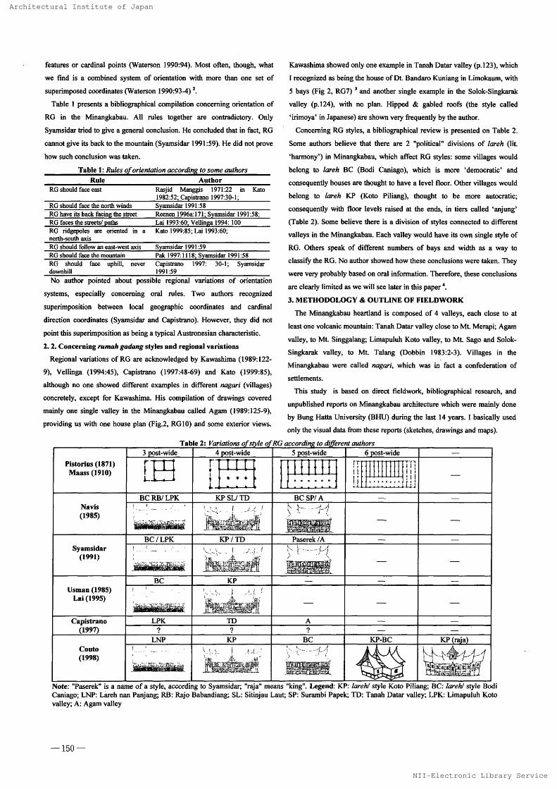
2.2.Concerningruntdegadengstylesandregiona]variations
Regional variations ef RG are ackncrwledged by Kawashima C19S9:122-
9), Vellinga {1994:45), Capistiano (1997:48-69) and Kato (1999:gS),although ne one sbowed different exarnples in different iurgari (villages)concretely, except for KawashimL His comp{latien of drawings covered
mainty one single valLey in the Minaiigkabau cal1ed Agarn (19S9:125-9),
providing us with one house plan (Fig.2, RGIO) and some exterior views.
Tsble2: Finriaiionso s leo
Kawashima shewed only one example in Tanah Datar valley (p.123), which
I recognized as being the house of Dt. Bandaro Kuniang {n Limokaum, with
S bays (Fig 2, RG7)3and ancFther single exainple in the SoLok-Singkarak
valley lp,l24), with no plan. Hipped & gabted rvofs (the styte called
[in'mcya'
in Japanese) are shown very bequently by the author.
Concerning RG styles, a bibliographical review is presented on Tahle 2.
Some authors believe that there are 2 "political" divisions of lareh (lit.
`hannery')
in Minangkabau, which affect RG styles: some vi11ages would
belong to lareh BC (Bodi Caniago), which is more `democratic'
and
consequently houses are theughr to haye a Level flcor. Other villages would
belong to ltueh KP (Koto Piliang), thought to be more autocratic;
consequently with floor levels raised at the ends, in tiers calted `ajung'
(Table 2). Some bel{eve there is a diyision of styLes connected to different
valleys in the Minanglcaball. Each valley would have its ovnt single sty!e of
RG. Others speak of different numbers of bays and wicfth as a way to
classify the RG. No author shorved hovv these conclusions were taken, They
were very probably based on oral infbnnation. Therefore, these conciusions
aJe clearly limited as we will see later in this paper 4.
3. METHODOLOGY & OUTLINE OF FIELDWORK
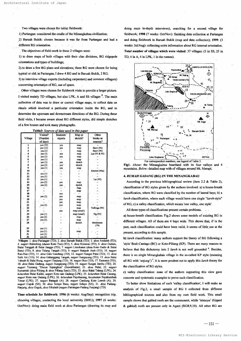
The Minanglzaball heart1and is composed of 4 valleys, each close to at
1east one vo]canic mourrtain: Tanah Datar yallcy close to Mt. Merapi; Agam
valley, to Mt. Singgalang; Limapuluh Keto valley, to Mt. Sago and Solok-
Singharak vallcy, to Mt. Talang (Debbin 1983:2-3). Villages in the
M{nanghabau were called nagan'. which was in fact a confederation of
settIements.
This study is based on direct fieldwork, bibliographical research, and
unpub]ished reports on Minanghabau architecture which were mainly done
by Bung lhtta University (BHU) during the last 14 years. I basically used
oniy the visual data ffom these reports (sketebes, dTtnvings and maps).
RGaccorzfih todi erentauthors
Pistorius(1871)Maass(l910)
Navis(19SS
Syamsidaf
(1991)
Usman(1985}
Lai (199S
Capistrano (199DCellto(1"op
3 st-wide
Z,HBC RBf LPK
llI.t
././ t./i'tt .1・dw・
BCtLPK titt
,n/L 't-
'"
"L'
"
BCl/.
.'H'ttt 't lt.' /t k ,.
LPK?IINP
l.. , .T.,,,,;.,t'V'/'/'].;/.
t .ttdee w.
4 t-widert,''L--"
KP SU TD':'・i,i,gei''
f,itllig
'
KPtTD
lkii$.T.thshig;lilee'
xu'i-'--V
i.l..igi=LiNl.as..wwl,.til, ,//.xD?mp
"' /''1' 11 't't'f,,,
,.ffk.tw,k'
5 st-wide
------
BC SPI A
c・- }・-, ,-t",,.H 4
-] H
eel.t 'l ,.
Paserek/AF.t-・-... I.・l・> ..
-t ,1,,
s
A?BC)
i' Jt
"'-1"' ",・'i
)t t/t
ewtw
6 t-wide
rl,iL rr.l.t
u i' ll iL"-;
KP-BC
t`
KP ra'a
Note: "Paserek" is a rtame ef a style, according to Syamsidar; "aja"
means "king".
Legend: KP: larebl style Koto Piliang; BC: ldrebl style BodiCaniagr); LNP: Lareh nan PaJljang; RB: Rajo Babandiartg; SL: Sitiniau Laut; SP: Surambi Papek; TD: Tanah Datar valley; LPK: Limaputuh Koto
valley; A: AgEJn yalicy
-150-
NII-Electronic
Architectural Institute of Japan
NII-Electronic Library Service
ArchitecturalInstitute of Japan
T'vvo viltage.s wcre chosen for initiat fieldwork:
1)Pariangart:considered.thecradleoftheMinanglcabagcivilization;
2) Baruah・Bukik: chosen because it was fhr ffom Pariangan and had a
.differentRGorientation. , - ,- ,
liie objeptives of field-work i.n these 2 vi11ages rverd:
1) to draw maps of both villages with their clan divisions, RG ridgepole
orientatipnsaJldtypesofbuiLdings; , .2) to draw a few RG plans arLd elevations; these RG were ghosen for being
typical or eld; in Pariangan, I drew 4 RG and in Baruah Bukik, 2 RG;
3) to interview vi11age experts (including carpen!ers) and cemrnen vi11agers)
cencerning orientati,on of RG, use of space.
Other vitlages were chosen for fieldyork yisits to provide a'larger picture.
I yisited mainly TD vi]lages, but also LPK, A and SS vi11ages 5. The rnain
collectien ef data was/to draw or correct virlage maps, to collect data on
rituals Jvhich involved a particular orientation ・inside
the RG. and to
deterrnine the upstrdan] and dewnstream direetions ef the RG, During these
field visits, I became avvare about RG diffbient styles, did simp]e sketches
'efa few houses and took many phetographs.
Table3:Sourcesotintaasedinthisr
Visited?Students,Maporothervillsgo'psumberTepOns
'sl[etch?bboksor
efda sources?1yes(31} yes maP '1yes(12) yes maP Basri(94)3 yes(2) ' map Basri(94)4 yes(5) ym mapIniC93&9S)
s yes(2) ys rnap '6 yes(o ' map -7 yes(3) yes shetch 's yes(2)
'ymsketch -
9 yesfl) ys maP '10 ' - - Reenen(96a)lt ycs(T) - ' T12 yes(1) ' L L13 ycsCt) ' - IAi(9S)14 yes(3}
'ymrnap -
IS yes(2) yes skcteh '16 ' '' rmnp '17 - . maP 'IS ' yes・'' '19yes(2) yes maP '
,mo ' yss map '21 -
yes map '22yes(2) yes map
''est.' ' mapVelSinga(94)
24 Lyesmap(smal])
-25ycsCO 'rnap(srnal])Ng{93)26yes{2) - map -
・27yes{1) . map T2S - ' sketchBeckmam{79)
29 yes(t) - ' 'soyes(1) ' maptuz'
31yos(1) - ' -31 2 - - -
Villages: 1. desa.PariaTigEri (TD); 2. desa Baruah Bukik (TD); 3. desa Andaleh CTD);4. nagari Balimbing <dustm Koto Tuo) (TD); 5, desa Kinawai CTD}; 6, desa Gudarn,Balai Tariggah &' Balai Janggo CID); 7. nagari Limokaum (desa Koto Gedis & Balai
Bfftu) CTD); g. `iesa Talang Tangal) (Il]); 9. nqguri Batipuh Ateh (TD); 1O. nqguriRao-Rac CTD); 1l. etesa Galo Gandang CID}; 12. ragaii Sungai Patai (rD); 13. desaSulit Air CrD); 14. desa Galanggang Tangah, nqgari Sungayang,CTD); 15, desa BalaiTat,uelh & Balai Bung uagtLri Ta[ijung CID); 16. hagari Buo CID); 17. Kurnanis (TD);18. desa Balai Gadans nogtui Sungayang CTD); 19. n4gari Sungai Jambu {TD); 20.nagari Tiumang
"Dusun
Sipanglma'i (Savvahlunto); 21. desa Pulai; 22. nqguri
Surnanialc (desa'PMang & desa HLiang Sani) ,(TD);
2]. desa Balai Talang (LPK); 24.
kelurahan Balai Kaliki, nagari Koto nan Gadang a.PK}; 2S. kelarahan Balai Cacmignagari Koto nan (tadang (LPK); 26. heinrahan Payobasung keaamatan ?a)ralaJrTtbuhTimur (LPK); 27. naguri Batagak (A); 28. nngari Candung Koto Lavveh {A); 29.nqgari Cupak (SS); 30. desa Selaye Bam, nagari Selayo (SS); 31. desu Padang-Par!iangdesaGuguk,desaSikaladi(nageeariangan-PadangPailjang)CTD)
11rne schedule.for fieldFvork: 1996
(6 weeks: A'uglSep):
recognition
trip,
choosing vitlages, contacting the loeat unlyerstty (BHU); 1997 (6 weeks:
OcttNov): doing main field work at desa Pariangan (drawing its rnap and'
doing main in-depth interviews), searching for a second, village for
fieldwork; 1998 (7 weeks: OctfNov): finishing data co11ectio4 at Pariangan
and doing fieldwork in Baruah Bukik,(map and data co11ectiori); 1999: (3
weeks: JullAllg): cDlleeting extra informatien about RG internai erierrtation,
Tota1 number of villages wbich vvere visited: 37 villages: (3 .in SS, 25 in
・ID,4in A,4in LPK,1in the rantau),
FoT cotrespondent numbers, see legend'ofTable 3.Figl. Above: the MinaJighabau heauland with its four valleys and 4mpuntains.
Below:
detaited
rnap
with
ofv,
i'llFges
arvund
Mt.
\erapi. ,
4. RtijlfAH GADAIVC (RG) IN THE MINANCKABAU
According to the previous bibtiographica] review (item 2.2 & Tahle 2),
classification efRG stytes given by the authors invoLved: a) a heuse-breath
classification, where RG were classified by.the number oflatera1 bays; b) a
lczreh classificEtion. where each vi]Jage would have one single ''lareh-style"
of RG; c) a valley classificatien, wtiich meahs 'one
yalley, one style'.
Ail three types ofclassifications present certain problerns. -
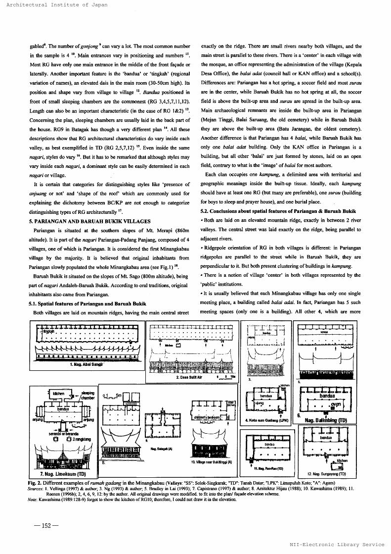
a) h6use-breath classification: Fig.2 shows some models of existing RG in
different villages. All of therp,are 4 bays 1videiThis shows that if in the
pasg such classification could, have been .yalid, it sEems of li"le. u, se at the'
preseng according to this sampte.
b) tureh classification:'mariy authors support the theory of RG folrowing a
'styLe' Bodi-Caniago (BC) or Koto-Piliang {KP). There are rnapy reasons to
believe that this dicbotomy into 2 lneh is n6t well grounded 6. Besides,
,there is no single Minangkabtiu village'in the 'so-called
kp style (mean,ingall RG with
`aiijung') '.'It
is rnore prudent tiot to apply this lueh theory for
the classification of RG styles. .'
cj valley classi'ficalion: none of the authors kuppo4ing this view gave
conerete and systematic examples to prove such classification.
To better show limitations ef such 'yalley
ctassificatien', t will rnake an
analysiS'of Fig.2, a smatt sample of RG 1 coliected fum aiikrentbibliographical sources and also fivm my own field werkL This srnall
sample shows that gtibled roofs are the corrrrnopesg while `irimoya'
(hipped& gabled) roofs are present enty in Agany!.(RGg.9,1.0). All pther RG are
-151-
NI,I-Electronic
Architectural Institute of Japan
NII-Electronic Library Service
ArchitecturalInstitute of Japan
gabledS. The niunber ofgonjong S can vary a 1at. 11)e rnest cornmon number
in the sample is 4 'O.
Main entrances yary in pesitioning and numbers 'i.
Mbst RG have only one main entrance irt the middle of the ffont favade or
laterally. Another important feature is the `bandua' or
`tingicah' (regional
variation of names), an elevated dais in thc main room (30-50cm high). ks
position and shape yary frern vi11age to village i2.
Bcpidita positioned in
front of sma]1 slbeping charnbers are the cornmonest (RG 3,4,5,7,11,12).
Lengtb can also be an impertant characteristic (in the case of RG 1&2) tS.
Concerning the plan, sleeping charnbers are usua1ly laid in the back part ef
the house. RG9 in Batagak has though a yery diffbrent plan '`.
All these
descriptions show that RG architectural characterisdcs do vary inside each
valley. as best exemplified in TD (RG 2.5,7,12) 'S.
Even inside the satne
naguri, styles do vary i6.
But it has to be remarked that akhough stytes rnay
vary inside eacb turguri, a dorninant styLe can be easily detemined in each
nqguri or village.
it is certain that categories for distinguisbing styles ]ike `prcsence of
anpmg or not' and `shape
ef the rooP which aJe commonly used for
explaining the dicbotomy between BCiKP are not enough to categorize
distinguishingtypesofRGarchhectura11y".
5. PARIANGAN AND BARUAH BUKIK VILLAGES
Pariar}gan is situated at the southern slopes of Mt. Merapi (860maltitude). It is part of the ncrgari Pariangan-Padang PaJlj ang, composed of 4
yBlages, one of which is PadarTgan. It is considered the first Minangkabau
vil[age by the rnajority. It is believed that original irthal)itants fforn
Pariangan slowly populated the whote Minangl[abau area (see Fig.1) 'S.
Baruali Bukik is situated on the slopes of rtrt. Sqgo (800m attitude), being
past of nagari Andaleh-Baruah Bukile According to orat traditions, origiaal
inhabitants also carne ffom Pariangan.
5.1. Spatial features of Pariangan and Bstuab Bukik
Both vi]lages are laid on mountain ridges, having the main centra1 street
pm--.....-..-......-....----.....'-.
t.NagAbeiSangir'
exactly en the ridge. There are small rivers nearby both vi11ages, and the
main street is parallel to these riyers. There is a `center'
in each vi11age with
the mesque, an office representing the administTation of the vi11age (Kepa]aDesa Oence), the balai crelat (oouncit hal1 or KAN office) and a schooS(s).
Differences aie: Pariangan has a hot spring, a soccer field and rnest surau
are in the center, white Baruah Bukik has no hot spring at atl, the soccer
field is aboye the built-up area and suratt are spread in the built-up area.
Main aJ=hacolegical rernnants are inside the built-up area in Pariangan
(Mejan Tinggi. Balai Saruang, the old cemetery) while io Baruah Bukik
they are above the buiLt-up area eatu Jarangan, the oldest eernetery).
Another diffleTence is that Pariangan has 4 balai, while BanJah Buldik has
only one balai tdo building. Only the KAN office in Parlangan is a
building, but atl other `balai'
arejust formed by stones, laid en an open
fietd. contrury to what is the `irnage' of balai for most authors.
Each cLan occupies one hanlputrg, a deiimited area with territorial and
geographic meanings inside thc built-up tissue. Ideally, each konrpung
should have at least one RG Out many are preferable), ene surau {building
for bcrys to sleep and prayer heuse), and one burial place.
5.2. Conclusions sbo"t spEtial features of Parisngan & Baruah Bukik
.Both are laid en an elevated mountain ridge, exactly in betwecn 2 river
yalleys. Ihe centTal street was laid exagtly en the ridge, being parallel to
adjacentriveTs.
e Ridgepole orientation of RG in bcvth vi11ages is difTlerent: in Pariangan
ridgepoles are parullel to the strein while in Baruah Bukik. they are
perpendicular to it. But beth present clustering ofbuildings in kmnpung.
. There is a notion ef vi11age
`center'
in both vi11ages representefl by the
`public'institutions・
e It is usually believed that each Miear]gl[abau vi11age has only ene single
meeting plaee, a building called balai culai. in fact, Pariangan has S such
meeting spaces {onty one is a building). All crther 4, which are rnore
i'i'"E..i・4.llil//i・'L,{:or-wt ,
i..,;/.tu:...;,.LL.x.i
)Ntl)s--.・,-"tliifgeee.geS.-ge3.
im
---tm.mp
lati-
-.'-.'-
'tua.
5.
o4 dn-tftdF4---
----
t
,--
--
"mp.estas,kSA"
mure"en'bei'gg
ww- t
taVeege"eErHrkditrgj(N
t4KotomaneedortgILPK)
tm
btue
---e-ll-
,lt-,e,H..a,o{m)ttskitetHi
t2.hlagwn(TD)
Fig 2. Different examples of ramah gmbng in the Minangl[abau (Valleys: "SS"/
Solok-Singi[arak; `'TD"/
Tanah Datar; "LPK",
Limapululi Koto; "A":
Agam)
thurces: 1, Vellinea (1997) & auther; 3. Ng (1993) & autho; S. Brudle]r in Lai (1993); 7. Cqpistrano <1997> & authog S. ATsitektur Hijan (19S8); 1O. Kawashiina (1g89); 11,
Reenen (1996b); 2, 4, 6, 9, 12: by the aiithor. Al1 eriginal drawings were modified. to fit into the plamV faeadc elcvation scherne.
tVbte/ Kawashirna (1989,128-9) forgot to show the kitehen ofRGIO; therefore. I could net dravv it in the elevatien.
-152-
NII-Electronic
Architectural Institute of Japan
NII-Electronic Library Service
ArchitecturalInstitute of Japan
ancient, are formed by sitting stones oc `menhir'-like
stones laid on an open
field.6.
0RIENTATION OF THE RMId/AH Gt4DAiVG
6.1. 0rientation of the RG in Pariangan and Baruah B"kik
Geographically the two villages ate very mucP similarly Iocated with
sirnitar main elements. H6wever, RG ridgepoles fforn bariangan are parallel
to the riyertstreet, while Baruah Bul[ik has rnost of its RG with ridgepoles
perpendicular to the streetfriver. Pariangan has some `experts'
of tradition
whg provided me with sorne dafa conce"iing orientation ef RG as shown in
Table 5. Baruah Bukik villagers had less to say conceming orientation of
RG (Table 4).
As segn in TabLes 4&5, oral rules stated by Pariapgan and BanJah Buklk
vi11agers were confirmed in reatity. Orientatien rules fforn Pariangan cannot
be applied to Baruah Bukik and neither the epposite, except for the rule
concerning alignrnent of ridgepoles. ThiS proves that regional variations
also occur for ora] rules oforientatio4. All data presented in TabLe 1 taken
ftom different bibliographica] sources looked contTadictory because "eywgre pTobably based on or.al data coming ffom different viIIages and were
mistakenly thought' to be valid for all Minanglcabau ".. Syamsidar (199 1:59)
conside.red ora1 inforrnation "wTeng'.,This
is also false, once ruLes work
vvell within vi!lage borders, as seen in Pariangan and B. Bukik.
lt is clear that systerns,of orientatien in ny(inarigl[abau are Austronesian,
with supeimposition of coorainates (using both LocaVgcogmphic
coordinates arid cardinal
'points). These superimpesed coordinates are
biased though, at least foT PariaTigan. wnen there is contTadiction in th'e
rules, cardinal points are discarded and Loca]/geogrephic coord{nates
mainta{ned . This is seen in the example of the RG of Dt. Rajo Gagak,
which was originally built facirpg to the easg but giying its back to the street.
To fhce east is considered `good' but 't6 give its back to street', bad. Due to
problems of lineage continuity and fighis in the faini]y, the RG inhabitants
decided to change the positien ef the fagade. Nowadays (t fboes the street.
Other 3 houses in the same condition had Flso giyen'priority to the
locaUgeegraphicrule"(seeFig.'3}. ・ '
6.2. 0rientation of mmah gudong ln other viltages
'
In order to give a Larger picture concprning the Minanghabau system 'of
orientation, l decided to check whether other vi1]ages also fo]lewed a
local/geographic orientation toward elements like rivers, streets and
mountains. `StTeet',
`river'
anq `mountain'
weTe bequently ched by
vilLagers and by the previous bibliographicat review as erientation elements.
Tlterefore, I cornpiled a table with RG orientations in 30 vMages (Table 6).
According to Tabte 6, we can concLude that:
1) RG are paratlel to gach other. but many viUages'present 2 rnain
directiens of RG orientation: S2% of yilLages have a singlc ridgepole
direction (catled Dir.1 in Table 6), while "% of villages pFesent 2 RG
ridgepote directions (called Dir, l & Dir2), . ,2) RG are usua]ty paralleL to the rnain street. Dir.1 (the mairt R9 ridgepole
direction in a viNage) is paraLLeL to the street in 94% of cases. Only 8% of
cases show that ridgepoles are perpendicular to the streeg like in Baruah
Bukik. [[1)eTefore, Baruah Bukik is an exceptiona] case.
3) RG ridgepoles are also parallel to the ctosest river(s): Dir.1 is paraLLeL to
a river in 80% of the yMages; in 20% of viLLages, it is perpendicular. to iL
4) ln all cases when the Dir. r of a village tied perpendicular to a river, it
L, epstrean"i' i'u
"rD'ab1aiilpmgReio-pisling・
.Betnig. t
ean"amsl
A itver
,',
'r'-;7;
X7-mny1 rpinam:x>v:
;tKatag -.Kto
1hee'k S
ptkeop:--":
'ome
ny・ , li y'÷ipt
-N
[)esa Pdriajpn St
,iiIX
pmem
Xes
)li s s 1' l
-.-l
st '7'
es2-
" 4-.
3- n-
8 ℃!・ ¢t nthiJ
skectt,1
100,
t
s t dwntuth
-m
il
dlll iie i,;
'j " , e,
,6 ・A
℃.taio,*l5・
lli.9ii'e'
e{' ll
t '; '
lthtaV
I l simintrg
Sbi SY,
t
s-gB
Ege・・--
gE・e・--.
8g=::-
;il
VlieetbmtaRts:t.nospa;2.KANoS$oeueutaFleadettreti#ageo"ice;4.sdwa;5.masprk-etseccetfield;sueorpaptshmme)8.aviertptuthtS.ingeemveleortaopsnfididtsclalathstttrigstorms
Fig 3: Map of Paiarvori di) ds mtinatemAents GRG eriatagan
tEGE"e
ehamhgadang. etrance--- tiueretuur-Lpefca
Btetg:'SrLthr
ti"/
ix"l・ikiikmm'
opabvm7,' ca l itt
,6
eras uet:?tt/ T- -7
ttt t 2.
tl rioe ' 3-
.
.tlssbu
"<Eb
a-'"6
e6
de,ds ¢ .6
.`
.,
o6g6 6,- .-
M6--- 66 7. 7.
C!K!, 666
6
6 6・earvehButdeE56M X.bma.
bM
useMtreesA
t -s!g!!ts.t
rt,er ntbeestiEiilT ELEuATIDnAA
uSeMtmstm
e--s- :
E・ e
Ese--
za:pg:-
irl lfsap
eamehgedtng. orrtma?ee--
rilier
eli-eetsmS:t.rrpspa;2.KANotiee[-rih-taisQt3.tfEa:oftrveheaddltteiftrege;aschoot;6.swerbeU;7.suevlpthm1;e.anha:bgd3the;s,taysepmFig
4: tsmp ot eaneeli evrk uitn ts mcinetements 8 its RG uterteticm
-153-
Architectural Institute of Japan
NII-Electronic Library Service
ArchitecturalInstitute of Japan
was revealed that these ridgepoles are, in fact, atigned to a mountain top, tt
seems that orientation respecting a riyer coordinate was discarded in order
to cope with an orientation towards the top ef a mountain earuah Bukik
also belengs also to this case 2i).
5) The main RG ridgepole orientation (Dir.1) usually points to a mountain
top・
The curiois fhct is that no one in the bibliography or in rny field work
referred specifically about `ridgepoles
pointing to the mountaln' !Z,
but enly
`fhcingthemeuntain',whichisverydifTerent".
Baruah Bukik (TD), Andaleh (TD), Galo Gandang (TD). Koto nan '
Gadang (LPK), Candung Koto Lawas (A) all had perpendicular erientationtowards the closest rivers (Table 6). In all those cases, ridgepoles pointed to
)vlt. Merapi instead ef fo11owing the aligrmient to the ctosest river. This
strongly suggests that Bamualt Bukik vi11agers, in the distant past. chose to
bu{ld their R{] with ridgepoles pointing not to the cLosest rnountaing which
was Mt. Sago, but to a fmher mountain, Mt, Merapi, ffom where thcir
aJicestors were belieyed to have been originated from.
63. Cbronological dimensions of erientation te-rsrds the moumtain
The oldest site which had been found in West Sumatra is that of Mahat
(1,OOO BC to e, according to Jacob 1992:156). It is a burial site, with rnore
than 300 rnenhires. All ef them, which were excavated by Haris Sukander,
were pointing to Mt Sago's top (Surya Helmi 1998). Orientation towarT}s
the mountain is therefore an ancient prqctice in the Minar]glcabau area.
Recent gTaves, though, all have orientation towards Mecca due te Islarnic
influence.
in Batipuli (TD), at the Gunung Bungsu she, one aan find grEves with the
oLd mountain orienption but also graves oriented to Mecceg according to
reeent excayations (MgKinnon l993:30-6), In Pariangan, otd menhires are
said to point to Meceag but whenIchecked them.Isaiv that they in fhet
point to Mt. MeTapi (grarrqyard at Batai Saruang, Mejan Tinggi and
Kaburan Pajang), not to Mecca,
ln Batipuh Ateh (TD) there is a ritual counting of rice yields which is said
to be `facing a direction in between Mt. Merapi and Meeca'. Mecca is to
the wesg Mt. Merapi exactly to the nomb, so villagers face in between, to
the NW while counting the rice yie]ds (BHU reports). This shows that some
Tabte 6: thientation ofRG riagepoles in 30 Minatrghabatt vUILrges
mmArenemara)GEsMePeEeFnc ies.ne:"s:.'mrc.'osumK*'ram.wa.'tF':-mm-an.'.;
PEMorZeFasflesmaneHmua-D-Cl
roactrmrmexSTptTTEmaE?M-nweIUXEmuewDZ2melmeRRmp
mm mmmue"
!?mpael
ms1escmptcoIteszzrEsres VESe-orapt1
2+oR-2NflLL]orstcvsuonmTenffEFempenmmeweop)
3.oR-2sttza1}esscssxoxm,tsnTsmemspaampt]manevap.
,mo4za(zaLlmstewmsPnvL
IESFma5s・IVEmstt-muSaeol
5.OR.2fi[mizzsu'exmsms 1.DR2S
sms1te(M)teevzzommsms etpatbMcrePl
Tmstepossery-)tcetsonen-" m
sms1as[M)tcasenzzYESrEs pm1
s.eR-2fi[za1;e2atasonmerEs ua1
s+OR-2-'-lom-- h\Tzpaeisls
tl+OR-2ptorrSldivoxnrasveSmaOles"tsaj]
t2+OR-2 zzssscox ms nores
B+OR-Nust-m-'msms o
t4ms1orEALUtavsomuxmsms mo
sms1M[aptaxomesms no
tsmstMfne3taxosonmsms mspm
tl+OR.2n[mpmsesonmsmsvespm,#etcu
is+OR-iTHrwt-ewmatox-ny--veseisaj1
ts+OR.2"{ua]9Slsuzzmsms vepmtapt1
mms1sutll]torntcuesmsres -
+OR-
TES,TO
M t13[PU]lmaones ESetins'inpa-h-HER
nmst tco)cuesmsrEs o"ms`rema;1coScucumsms ny
esNrm1asY-twxom msms・]
1rlsms1Ym1asonomMT5perm.IEs trEselazptl
16n+oR.2T"nvasscumsms resptorig]
N+OR.2 S9sc"tommsms mo
z+ORJ2 nvmomM,TSmmms ma"itDM2iSmp)
ts+OR.IeH-are-----ms--
nVS1tstasonanmsmsMOtnl-ntiutstc)tstt
nt
ffor vi11age nurnbers, refer to Table 3; ''DIR.1"/ main direetion ofRG ridgepblesin a village;
"D[R.2i'; seconda[y direction of RG ridgepetes in a village;
"RG":rwvtali gadong;
"peroent.", peroentage;
"ridges"/ same as ridgepole)
Tabte4.RulesoforientationaccordintoBaruahBukikinhabitantsandresultseffieldworkcheckinthevatidioftheseruIes
RutesoforientationBukik InforinaDts Checkinthevalid'oftheseru]es1.Ridgepolescannotpointdownwards Jamal Indeed.21RGofatotalof24areperpendieulartostreet,net
followinthestreetdownwards.Tbreear=am11eltostreets.2.RGridgepolesshollldbeplacedsidebyside,with
rideolesasacontinuoustine
Jarinan lndeed,closeRGareallaLigtred
3.RGshouldfacethemountain Almasna&Jarinan21RGfaceMt.Sao;onl3donot.
Table5.RulesoforientationaccerdintoPariaiianinhabitantsandTesultsoffieldworkcheckinthevalidieftheserutes
RulesoforientationPariallD Informants Checkintheyalidioftheserules1.RGfacadescanneveropcntothenortitorsouthinfactNWorSE
Dt.Mangkuto Indeed,noRGfacadesopeneithertenortliorsouth(nortoNWorSE
2.RGfacadesrnustopentotheeast(infaegma
Dt.Mangtuto&GarangOf3SRG,27(770fo)opentotheteast'andonty8(2301o)opentethetweSt'・
3.Ridgepolesshouldbeparalleltoariyeror'"vers
Dt.Mangkttto,Suri
Dira'e&GaranIndeed.all35RGareapproximatelyparalleltethe2riversthatrun
toeachsideefthevi11ae4.Ridgepolesshouldneverbeperpendiculartothemainstreegbutrnustrunara11eitolt
Dt.Manglcuto,SuriDira'e&Garan
Indeed.noneofthe3SRGareperpendiculartothernainstreet
S.rudgepolesffommanyRGwhichareaLignedareaoodarranementcalled`sinobasiek'M.Garang
Ofthe35RG,13(4601o)areaLignedingroupsof2or3RG;6(2501o)aremoreortessalied'S2901oarenotalied7areisolate
6.Bedrooms(biliak)canneverfacethemainstreet
Dt.GaransS.Dhajo&kSati
lndeedthereisnosingleRGonwhichbedreomsfacethemainstreet
-154-
Architectural Institute of Japan
NII-Electronic Library Service
ArchitecturalInstitute of Japan
Minangkabau vMagers try to oombine older rules {n ordcr to fit into a nevier /system ef orientation, in this cake, with Islain..lt sgems though, when they tt 'fhee contradictory rules which are opposite and ne conciliation cah possibly ' ttbe rnade,
villagers
choose
what
thq)[
think,
is best{
which
in
the
case
of
Pariangan, is related to locaVgeographic coordinates and not te cardinal
pomts.6.4.
0rientatiop decided by common agreement
The orientation of RG is decided by common ,agreement even today, in
Sungai Jarnbu (T[D), a vi11agef decided to isuild, his RG with its ridgepole
perpendicular to Mt. Merapi a few Years ago, contrary to the great maj ority
of other RG. His -ptinishment',
accoTding te a viltager, was that he became
excluded frorn all village most important activities arrd decisions. There was
no council meeting that decided his 'punishment';
it was decided by'common
sense'r according to an inft)rniant. in Baruah Bukik, in oase a
villager would'1ikp to change orientation of his RG, he has to ask the
permission of the counpil, agcording t6 another inforrnanL ln Pariangan,
there is ne need to haye a formal councii meeting for deciding a RG
orientatlon because this affair is seen as a private prebterp of each
sublineage, But yi11age.rs sti11 maintain
'obedience'
towatd certain rules as'it
was seen in this paper, ・with fear that brcaking them weuld cause bad
consequences tp their fimilies like.lack of fertility, failure of rice crops,
sickness and other negative facts.
7. CONCLUSIONS
1) This paper clarified about the mistaken concept of F division of RG
styles into lareh or into valleys.
2) lt concretely showed difTerent modeLs of RG ffom a few villages in the
Minangkabau heartland, and explained main archhectural features which
seem important for chafacterizing a RG. ,
3) It etarified basic spatial characteristics of twg yMages. Pariangan and
Baruah Bukik.
4) It clarified that orat rules of orientation vary regienally. It concLuded that
all data fouhd in the bibliographical review concerning orientation in the
Minangl[abau looked contradict6ry for the fhort that they vveTe probably
based on ora] information ftom d{fferent villages and were thistaken]y
thought to be valid fpr all Minangkabau. '
5) Minangkpbau has a typical Austrongsian system of orientation with
superirnbosed' sets of rules. This paper clarified about
'the nature of
s?perimposition Oreference,,, t6r loctiVgcographic ,ooordilites instead of
cardinal directions; merging of old and new `hely'
directions such as ' t t`rnountain'and`Medca'directions).
・ '
'
6)'it showed that thefe,are certainly c'ommon orientatiort rules which are
valid for at least 3e Minangilabau villages, independent'of regiena]
variations of oraL ru]es. These are: a) RG aie v$ually pam11el to nearby
rivers; b) streets are laid paral161 to rivers, therefore, RG ridgepoles are
usually parallel to streets, but not aLways; c) RG ridgepoles very often point
exact]y - or c]ose to - the imaginary axis which links the RG to a mountain
top・7)
lt suggested that the reason for the strange orientation of RG ridgepoles
in Baruah Bukik is retated to probable ancient worship of the mountain CMt.Merapi).
Limitations of this' paper were: srnall samples of RG for the discussion of
architectural features and lack of analysis about intenna} orientation of RG.
NOTES:
''
'1. M{Ist of the social groups found in indonesi.a speak Austronesian lariguage's.
'
2. For instanoe, Toajan housies always' fhce nonh, i, direction associgted with ijyer sourees (WaterSon 19po:94). Karp Batak houses arc belieyed to be aligned to the
points of the compass by Karo'vi11agers (Domenig 1980/127). Go £ s sfiowed they afe
in fact aligned according.to upstream and downsmeam (Goes 1992/12), In BalL in
thg Bali Aga type of vi11age, there is a clear superimpdsition of `kaja'
(upstm) and
`nomb' in the orientation ofvi11ages and houses earirnin 19g6). Another exqmple is
Pura Suranadi in Lombok island which points to the top of Mt. Rajani (Wakita 1996:1OO), although al1 otherlnea in the island follows the cardinal points.3. Kawashima (1989/123) though, preseTited e wrong plarL for this hovsc, with'9 bays ' instead ofS, which was probably the plah of the imous museum in Bukittinggi, fict
.thehouseofDt.BandaroKuniang. '
'
' '
''
'4. Benida.Beckrnann (1979,92-3} pointed inat, at least Dn matters of law in the Minmigkaha- a considerable distmce between 'ideal'
and bractice' does occur: what
people say is not neoessarily. correspondertt to the practice. This is also the case
ocrncerning diffeTerit RG styles/ 'ideal'
divisions of style and 'actual'
divisioris do not
necessarily comspond when checked in reality. a fact whieh I found lp my field work. Oral data can be used only as a 1imited too1, not as the only source for taltiing oonclusions, as it-probably was the case for the allthors cited in Tables 1&2.5. Through tiris paper, I will call the Minanghaball valleys as
tM]'
Cranah Datar valley>,
'A'
(Agan] valley), LPK' (Limapuluh Koto valley) and `SS`
(SolokSingl[aTak yalley).
6, First the nature of the lareh itself was always obscure, lacking histarical proog according to BeekrTiaim (1979/58.-59). Second some vi11ages like' Paiangaii and
Balimbing do not beleng to either BC noF KP, but to a third lareh, called Lareh nan
Pajang . A vi11age called Rao.-Rad pteenen 1 996a:71 -4) has elernents of the 3 lareh
BC, KP mid Lareh nan ?mijm]g altogether. Thirq the political divisien of vil1ages
into BCt KP soerns to have vveakened after the begirming ef the 19di oe[itury (Dobbin ]987).7.It
is also questionable wfietiier i,n the pgst there cguld have been whele villages
exclusively made er RG with anjung, once these buildines are more complgx to be
built, dernandmg much more resontces. (labor, cqpital, building materials}.
Nowadays, it is common to find a RG with 2 aojueg iSblated in the middle of many
RG with no anjtetg at al1, aceording to my fieldwork trips.
8. This shows a different pidwre from the one shown by Kawdshima (1989). whe
showed the great Tmajerity of buildings as being irimop (with hipped & gal)1ed roofs).9.
Fof al1 tnknown .words, refu to the glossary in the end of this paper. Variatioms on
the nuinber ofgonjongt ftom 4 e6 3,5,8,1O), te 6 paG7) to 20 ptGl).1O.
'Goajong beranda' op be laid over entrances 1ike ip RG 2&7.
11. RG2 {Sulit Air) has 4 entranoes. although it is an exeeption. RG5 ealimbirig) has 2
entrances. RG in Batagak have their rnain entrarice from the back side (RG8. 9).12. in Abai Sangh, the tingkah is to the left side (RGl).The btmdhah shape rnay vary/
see, for instance, the U-shaped.handua of RG6. RG 8&9 frem Batagak have no bandua; neither RG2 (Sulit Air) nor RG1O (Agam), al1 with oniy tevel floors.13. Sulit Air RG2 is citect as the IaTgest MinaT,gl[abau house (Kalo 1982/53-4 with 20 roofns and 64 meteTs long (Watersoh 1989/491), although at least one 1argeq house
exists ptGl, in Abai SangiT). RGI is 70 meters 10ng with 21 'fooms
(VeSlinga 1997/1,10) Besides the Sulit Air exarnpte BG2) is exoeptional once it was built by
4 different c]ans, whiIe the RG of Abai Sangh vvas bui]t for a single clan, qu usual in Minangl[abau (altheugh it is located in the rantau).'14. RG9 eatagak) has sloqping charnbers spread te alL 4 Obrners of the plan.15. Navis (1985), Syarnsidar (1991) mid Capistrano (1997) wrongly support the theery
'onevaltcy,,onestyle'.
' ,
16. ln Batagalq RG 8&9 haye very difftrent plans. .ln Balimbing RG S&6 haye a different shape of benLina and posuions of the mam entrance. ln Limokaum, RG7
has anjuang tp both sidds alinough many other RG with no anjuang do exis!,in the sarne vi11age according to rny fietd visits thewever, these we;e riot shown in Fig.2).17. For instance, the bo,mditaltinglph is a very important etement defining use. o'f space
and its symbolic in'eanings. Tliese am very similar to the tarijung'
Qf RG7, But the.
baridmiingiph is totally ignored in the classification done by most authors. RG6 has
alse dn eleyated floor to its 1ateral si4es (a U-shaped bandhaa). The left room ofRG]
is also called 'arijung'
(in RG4. it is called `ajung').
Excessi-e attention ,has beed
given to the 'mijung' }ike it appears in RG7, but other types of anjag, njuagt tingkq.h
haveboentota]IYignored.18. The Tambo (tradhional legends) ofPariangan explains hovv the first ancestor of the
Minanghaha- while tmetting by bbaj ssw the rdp of Mt. Merapi, which was smal1,
1ike an egg in the middle ,of the ocean. When he smpped'on'the isLand. the whbers
receded. He then descended from the mountain tep downwards, unti1 he found a hot
spring where he decided to make a seulement. Pariangan yi11age was then created,19. The ruLe RG should faoe eastd is approximalely valid in Pariangan (the real,,
direction is NE thoueti}, but not Teally yalid in Baruah Bukilk (10 RG face NE, 2
ESE, but 12 others aTe imretated to the E). No RG in the two villages fhees exactly to
the E. Conoerning the N direction, Syamsidar alTirTned that tRG
should faee the N
white in Pa[iangan the mule is `it should not fhce the Ni. This rule is not'valid in
Pariangan, but it soems valid in Barual1 Bukik {1O RG face NE, 1 t faoe NNE, oniy 3
faee diffetently). Ihe rude `facing
thle streetsi giving back to the simts:, although
very much belicved in Pariangan (RG camot give.iys back to the streets), has no
influence in Barueli Bukik (no RG seems Io be orieTited in re1ation to streeis there).
Conoerning the ruae 'iming
uphM,"or `facing
the mountain', it is valid fbr Baniah
Bukik in relation to Mt. Sago. tut net valid for Pariangan in relation to ML MerapL.
,
-155-
Architectural Institute of Japan
NII-Electronic Library Service
Arohiteotural エnstitute of Japan
20.In Ba川旦h Buk嵐 sudl oontra面Ctory rules we 【e not ibund, No one coUld explain to
me v/hy o ロ1y 3 houses weTe pa 【訓1el to血 e street w 丗 e 田10血 ∋were perpendicular ω 瓧.21.Syamsu直Asri’s papor(1996)誌a皿 exoeptian.副lthough be never made 盻 ロce to 血 :ridgepole. We can see 血飢 wh 飢 he mcant was 衄 山e ddgepole
’po 面
1敦》山e
mountain only 血 ough some of 血 c draw血gs in血じ paper. n 丘e work ofBa 訂 i(1994) 魄 B 踟 曲 B戯 曲 o 皿 脚 嘸 田山 。u 帥 血 e map of 山 e 晩 e h皰
an i且co【贓 orie皿ta面αn and he had no重 ref圃 SPeCifically to 「ridgepole
oden 甌 螂「.
22.Reasons for臘 呵 be ’loss of ornl truditions
,. Another reason 凶 山 e fact血 at
woTshipP 血 g an 轍 1sphjts of 血e mountains is not we 皿 seen by islarn se some
villagers prefer to hide their beliefS fピom 血 e public.
ACKNOWLEDGEMENTSτhis【esearch wou ■d mt be accomp1 均bed wi血 1血 c fhla轟cing support of 山 e JapanScimce Foundatio4 field wotk s血 oriZation frorn重he LIPI 皿 d thc imnense supPort舳 n Bung Hatta University, Dept of ArchiteetLuc staff and students . W 正thout endless副 (sWith Hannaini Darwis, the idea飴r 血is paper wouldhave never 踟 m maU 鵬 .
GLOSSARY−anJ’m 蓼g ti団肥d fioers議 bo山 sidcs(or ω ¢ side)ofaRG−hσtai:P且ace fbr oo 竃mcil mee 血 gs or o血町 魄 面百oロal meedngs
−balaiα面 ‘;oomcil h朗1−handha : eleva 団 dais of30 −50 inside d』e RG−desa a vi 【置age Ond曲 stTative unit )−Dt 二abbTeviation fbr幽 敏 ahonorific title fbr I eage chiefs−go脚 8 呻 血 g繭 ofaMi 鰰 鋤 … [Os騨 ・1山 e f−gonjong berancin:90噸0 π書跏 ve 伽e
「veranda 一亘繭(ol p肛 t(calledserambt)一か肋 の 砌 ;bipped and gab塵ed mof (at 町 m wed fセom Jap孤 ese )−kmnpang: arca within 出e v皿 age 」 with ω亘al and geographic otations
・IC4N ofice :Kerapa 血 i Adat Nag r {o『五〇e (an o 伍 cia 】p■a 石Dr adat mee 血 gs),kecamamn:subd的面 cI一舵 「〃 伽 ;pohtiじal d ct adm 血isl cd by血e ’u厂助 (v 皿age chief )一初 ‘o :a 曝 or fortificffbed vMage 曹蜘 ; c皿 膕 on of 瞭 (ofkOto )一如 励 ;hピ h団 mOny
’,an ’associaion1 of Villages er clmis ; Or a palitical party
−nagU7il oanfbdetation ofvillages /seui 6一
用 η’α翼:dlo 灯 Cgolo血 edl te前 ories by山e M 匐 b鋤 )曹manah gadon9 :customary he sse
N & Cecilia l993.’°R 樋sing 山 e House PosI amd FeediT〕g 血 e Husband・Givers:創heSpatial Ca釦巳gories of Social Reproduotion amo 重he M angk伽 u
”,血 恥 ∫漉
.Austronesim HoiLses. Can NUAPak Ok−kyung1997.
「iM血 angkabaiL Suma昿 E’7 in Enの,ctopedia q厂レ
’enmctrlar
A’c ゐ’‘eettcre げ the 物 厂跏[. Ed . by Pan101ivcr, Vol.2, l l I7−Ill9.?iStorius, A. vedcerk、 1871、 ∫ η aver de in’α泌 o 海ε Huishozading ’π depmbngsche Boventand . Z跏 mmel :Joh N m み 箔 n 血 Capistrano 1997
Parim血, Ardi p.1986」『肱 加θ毋如 ’∫ o 〃 加 的, Fomation ef lsland陏侮g ε」
Envirenmentat Hierarcly Ofthc厂ed−P ’ofane Concept in 84 ’ヴ.0 跖 ka Univ.二 doctoralthesis.駄asj 旧 M 皿n 咥男醸, M .1971、舶
.hangkOhau .’Sedjarah Ring肱 四 伽 .4必 呵肱 p磁 mg :sri
Dha皿 a 血 K 威 01982 .Ro 巳 囮 e囮,」. van .1996a. CentralPillars qゾ伽 月
’euse . CNWS Public. L £ id .− 1996b. P叩 er 山a 飛 fbr血e wo 【ks p
“Traditional dwellings in Westem ihdonesia”,Leiden.Surya Helmi、1998.血 tervicw at Suaka P ggalan S句arah dan Purbakala Sum
dan Riall, NormberSya皿 sidar , B. A.1991.!lrs’tekezar 7}’tidisiono ’ Daerah ∫吻 :αtera Barat. Dep、P 血d止 an dm Kebud町 班 m , Proyek Inv sasi dan P b 理 m Nil師一Nilai BudayaSym 釦 l Asri.1996.”The Changing pattern ef the M 血aog bau S 1 鱈 around
MI. M 脚 i”, WorkShop Tr組曲 mahons of Houses and Se団 鵬 血 W t
hldo皿 esi 糺 L£ idcn Unjv.Usm 叫 Ibenz洫 .1985 (1979 )R 跚 αゐG α加 冨 オ悶 惚伽 厂 7}磁 吻 ua ’Minanghabau .Proyek SasanaBudayaJakartaVo■lin呂8. M 肛 cel.1994.丿〜ta,,ah Gatlang Minangkahau.’Venzacular!4rchitecturejiem砌 !dnthropologiα d Perspec伽 8. M 醜 r thes蛉, R噂ks皿 ive[she 虻L 已id 一 1997.‘V{ouses , Stams and Change in a Milangkal)an V丗 age :Tlle Case of AbaiS田 げ ,pal矧 r presented fbr 〃 brshop 7ン呻 η ησ ’ion 【ゾHouses arzd Settle刀 昭 雌 肋
Meste〃 1ルidonesia. Leid Wakita, Yosh 血 sa et 詛.1996.“Od 囲 oロ oF Holy Plac 巳s and Se随i 彰s of 血e
Ba重血 ese.跏 d the Sasak血 L 厘bok Is d,1皿do煕 sia
”洫 AU , No .489,97−102, Nbv.
W 鰰 r 弸 ,Rox躙 a 1989, nMigTatio4 T 甜 on and Cha ¢ in Some Vem 踟
Arohh 加1es of dσn巳sial° BOURD 田 R、 Jea皿 pPau己ed虻i(叫 1)wellings SettiementS
a ノ轟ゴTrdiaation. La畝 London:IASTE, pp.447−501一 韮ggo,翫 乙醒 House’ an Anthropalogy己ゾ !lrchitecture切 踊 一East !「5’a.Oxford universityPress:S血 gapore
一 :h。 use fer praying and sl鵯 used by unm 矼 「iedrnen and male adolescerrts
尸tthrgkah:same as bandt砌
Abbr 巴 ▼血 t諭 ns : A : Agam v田1ey; BC : iareh Bodj −Caniage / BHU : B 皿 g HaUa
U血 versity;KP :lmeh Ko電o P田mg ;LPK :L apuluh Kotav2皿ey;RG ;nenah gadUngSS: So]okSing arak va 皿oメ TD :Tanah Da血 vaUey ;E : c 眼 W : wes 馬 N : north , S :
SOU 肛 阨 :n劇 詛 dSOon 、
REFERENCES & SOURCESA 闘 肚ek 血 r Hij麗 乢 198& EkSpedtSi勉 砌 ゐ Minang. Bandung: Universitas K 叙 olik
Parahyanga11.BEsrL Hasan.1994. Kebe厂伽 跏 R婢 昭 ゐ.Gmbng Datam rataπ臧刎 MinangkObau.Master dissertation. Yogyakarta UGM
Beコds・鱈 k匹 1朋 o, Franz v .1979. Prope厂ty 肋 Socin’α 励 面瞬 The Hague;
Martinus NljhoffB ■us ち Rob 巳比 L980.1,E 蹴 ly AustrorTesian soG 副 ergmlization : 血c eVid 巳n of
罫 e”in Curre翩 η伽 脚 吻 21No .2 ;205 −247
Bueg Hatts UntVersity〔BHU );1996 onwardS. reports 丘um s重ud ts(based on dheCtfie【d work )
Cap no .皿 血 1997. RecongtruCting f舵 Past ’ 伽 蜘 ‘ion げ Tractitionゴn PMest
SzamanranArchitecim ,〃 91・ノ99ノ.PhD dissertation, C。 b罰 血v醜 ,Cou ‘o, Nasba y.1998.ル臼肋 α 面 伽 ロ厂一Unsur Fiszaal puala Bangu 砌 η Tredisionat
MinangkubaUt Stiatu Kとび吻 5診那 ∫α 沈 M 直Ster djsso血 韮ion. nB , Bm 血田6Dobbio , Christ血 e.1987. lstamic 品 2v 庁vα’ism 跏 α C加 πg7
『 Peasan’ 亙 oo 躍o醒 y.
Londvn and Malmo :Sc 跏 dinavi徂 ln虹 恤 te ofAsi 田 i StUdies Monograph (1鑓
ed .1983)
Do 皿 on 嬉 Gaud巳nz.【980. TektOnik im P广’叨 ’〃陀 ηD ロ‘hbau. Z 叮 ich: .Goes, Boa血iz van dじτ、1992.『KUa :血e K 賍 o Ba慮ak Vmage as a Cultutal Ccmsロucti
of 血s Ecological Sur [oundingS”h】 5動〃nbotiC Meaning 加 Traditioua’Habitat陛Vol.42.
瞰 ¢ 且¢ y:IAESTE
jscob, T ku」 992.ηM 加 sia Malayu Kuno’「h】翫 励惚 5匂’ψ伽 漉 伽 κ跚 o by
PerTler血帥 D翻 T血gka【lJambし 151−157K 飢 o,TStl)Toshi 」 982.ルfatritiay and Migrat’on ;Evaining Minangkahau Tradi‘ions肋lhdOnesia. Iim Orme 皿university Press.− 1999,“00 aI 。 no H鈎 m 肥
”in StaVla’所 鰯 0麗..Kyo!0 :肋 gei
ICawash血 a, Ch巳両L I989. AJ’ia no Minku . T啣 o ;SoubO ShobOuMcK 血 no 皿, Edward e1 aL 1993. Penel’ご勧 rrediSiルfega枷 た di G 泌 娚 g BWigst4Ttnmah D ロ 如 厂,∫ 伽 . B 衂 口 gkar
Lat Chee Ki¢ n.1993.し‘DeduCing from Balimb 血 B: Measuring a M 血 angkabau Hous ♂
血 !望厂ch ’tecturv JournaL S 9鄲 :NUS− 1995.& ψ and kOoX Constnrct’0腐 of BOWtdSpace 跏 ∫な ∫繊 ロα ご厂σ 躍 House
Forms. Vol 1, MasterIhesiS, National U血versity efS 血8aporo.Maass. A 量fied.乳910. Durch k 加 尸atStm :atra . Ber ;Behr in C叩 iStrano 1997Na▼醸, A.1985.∠ TerkOmbtUT9 Jadi G 珮 AdUt c吻η κε鰤 π MinangkOba翼.亅田鰕 Pu 曲 Gra丘直P (苴984:first edi 虹on ).
和 文要 約
本稿 は、イ ン ドネシア国 西ス マ トラ州の ミナ ンカバ ウ族の 居住地 域にお ける伝統
的な家屋・ル マガ ダンを とりあ吠 家屋形 式と農村氣落の 構成を明らか にす る目的が
あ る。既往研究でのル マ ”ダンの 分類は次の ような方法であ っ た。 a ) 「ラル t と呼はれる区域での 分類 (た とえは ラル
・ボ デ ィ’チ ャ ニ ア ゴやラル・
コ ト・ビラ ンと呼はれる2っの 「ラル 」 における分類方法) ; 「ラル」 とは政治的ねまとまりを意味する現地語で,
”herm。nジ と駅されている。
ゆ 導の流 域での分類 (1つ の 流域に摯つのル マ 刀ダンの形式がある とする分類)
本稿 では、集落の区 分での分 類や流域 ご との区 分による以上 2つの分類方 法の 問題
点 を取 り上 げている 。そ こで、ミナ ンカバ ウ地域 の幾 つかの村か らルマ ガダ ンを具体
的 に抽出 し家 屋形式の 分類 を行 い、ル マ ガ タンを特敞 づけ る重 要な幾つ かの形態 的な
特色を示した。 次 に、パ リンガ ンとバ ル ア ブキ クの 2つの集 落 におけるル マ ガ ダンの特色 を、家屋の配置状況、地形の特徴、集落の建築的な構成要勦 、ら分折 した。 調査の 結果 、□伝 によるル マ ガ ダンの 棟の方 向の ル
ール は地 域性による変 化を示す
車が 分か っ た 。ミナ ン カバウ の 方位に閲する あらゆ る既往研究では、事実とは異な る
ような結論が 出され てい る。つ ま り、データ は.お そら く異なる集落間での 囗 伝の
データーから採取され たもの であ り、それ らの [コ伝のデーターは全ての ミナン カバ ウ
に対して当て はまる とい う、間違 っ た捉え方を して い る。ミナ ンカバ ウ族は 典型的な オス ト囗ネンア の 方位システ ム を使う。つ ま り、ミナ ン
カバ ウ族はい ろい ろな方位シ ス デムル を重ね あわせ て建築などに用い てい る.本稿は
この重ねあわせの性質を明 らかに している。基本的には地方性・地理 注のル
ール と方
位シ ステム を同時に使 うが、矛盾が生じる場合がある。その時は、地方性のル ールが
基本的 な方位 システ ムよ り強 く現れ る。また ,山頂 へ 向か う古 い聖な る 方向 と新 し
い He 8 へ の聖 なる方向 とが重 ね合わ され て用 い られ る燭合もある。少な くとも 3〔の ミナ ンカバ ウの 村には 、ロ伝のル
ールの地域による変化とは 別に、
確実な共通の方位の ルー
ルが ある。それは以下の とおりである。 a) 1 つの集落において、ル マガダンの棟は概ね 近 くの 川に対 して平行 に配置 される。 b) 集落中央の 街路は この 川 に平行なの で、ル マ ガ ダン の 棟 は殆どが街 路 に平行に
なる。c)ル マガダンか ら山へ 至 る軸があ リ、ほとんどの ルマ ガダンの 榛は山頂方向に向い
ている 。この ことから、バルア プギ クで の ルマ ガダンの棟の方位の特性に 古代の 山岳偲仰と
の 関連性が あ ることを示すこ とが出来る.
(1999年 6月 10 日原稿 受理,1999年 12月 9 日採用 決定〕
一 156一
N 工工一Eleotronio Library