
RSSI-Fingerprinting-Based Mobile Phone Localization With...
6
IEEE TRANSACTIONS ON VEHICULAR TECHNOLOGY, VOL. 63, NO. 1, JANUARY 2014 423 Fig. 6. BER performances according to M = 1/2/4 as a function of γ SR = γ SD when ω = 1. VI. CONCLUSION In this paper, we have presented the channel estimations for AF multiple-relay networks, particularly over frequency-selective fading channels. First, we have proposed the repeated known sequence con- sisting of Chu sequences, of which length depends on the number of re- lays and the maximum channel length of max(L h 0 ,L c ). It was shown that the structure provides the complete precoding between relays without the IBI and the efficient frequency-domain channel estimation. Second, we have a simple signed precoding at relays by exploiting the extended orthogonal codes. It was shown that the precoding does not limit the number of relays and completely decouples the CIRs between links directly at D. Third, we have investigated various properties of the proposed channel estimations through the analysis of effective MSE in terms of link parameters, i.e., ω, γ SR , and γ SD . Moreover, it was verified that the combination of the repeated known sequence and precoding provides the minimum channel estimation performance (in the LS sense). Finally, the performance evaluations have been accomplished to verify the analysis results. REFERENCES [1] A. Sendonaris, E. Erkip, and B. Aazhang, “User cooperation diversity. Part I. System description,” IEEE Trans. Commun., vol. 51, no. 11, pp. 1927–1938, Nov. 2003. [2] J. Choi, “MMSE-based distributed beamforming in cooperative relay net- works,” IEEE Trans. Commun., vol. 59, no. 5, pp. 1346–1356, May 2011. [3] S. Zhang, X. Xia, and J. Wang, “Cooperative performance and diversity gain of wireless relay networks,” IEEE J. Sel. Areas Commun., vol. 30, no. 9, pp. 1623–1632, Oct. 2012. [4] F. Gao, T. Cui, and A. Nallanathan, “On channel estimation and optimal training design for amplify and forward relay networks,” IEEE Trans. Wireless Commun., vol. 7, no. 5, pp. 1907–1916, May 2008. [5] J. Coon, M. Beach, and J. McGeehan, “Optimal training sequences for channel estimation in cyclic-prefix-based single-carrier systems with transmit diversity,” IEEE Signal Process. Lett., vol. 11, no. 9, pp. 729– 733, Sep. 2004. [6] M. G. Song, D. S. Kim, and G. H. Im, “Recursive channel estimation method for OFDM-based cooperative systems,” IEEE Commun. Lett., vol. 14, no. 11, pp. 1029–1031, Nov. 2010. [7] A. S. Lalos, A. A. Rontogiannis, and K. Berberidis, “Frequency do- main channel estimation for cooperative communication networks,” IEEE Trans. Signal Process., vol. 58, no. 6, pp. 3400–3405, Jun. 2010. [8] J. Coon, M. Beach, and J. McGeehan, “Channel and noise variance estimation and tracking algorithms for unique-word based single-carrier systems,” IEEE Trans. Wireless Commun., vol. 5, no. 6, pp. 1488–1496, Jun. 2006. [9] H. Mheidat, M. Uysal, and N. Al-Dhahir, “Equalization techniques for distributed space-time block codes with amplify-and-forward relaying,” IEEE Trans. Signal Process., vol. 55, no. 5, pp. 1839–1852, May 2007. [10] D. C. Chu, “Polyphase codes with good periodic correlation properties,” IEEE Trans. Inf. Theory, vol. IT-18, no. 4, pp. 531–532, Jul. 1972. [11] J. S. Baek and J. S. Seo, “Performance analysis of power control effects in channel estimation for AF relaying network,” IEEE Commun. Lett., vol. 16, no. 6, pp. 886–888, Feb. 2012. RSSI-Fingerprinting-Based Mobile Phone Localization With Route Constraints Sinem Coleri Ergen, Huseyin Serhat Tetikol, Mehmet Kontik, Raffi Sevlian, Ram Rajagopal, and Pravin Varaiya Abstract—Accurate positioning of a moving vehicle along a route en- ables various applications, such as travel-time estimation, in transporta- tion. Global Positioning System (GPS)-based localization algorithms suffer from low availability and high energy consumption. A received signal strength indicator (RSSI) measured in the course of the normal opera- tion of Global System for Mobile Communications (GSM)-based mobile phones, on the other hand, consumes minimal energy in addition to the standard cell-phone operation with high availability but very low accuracy. In this paper, we incorporate the fact that the motion of vehicles satisfies route constraints to improve the accuracy of the RSSI-based localization by using a hidden Markov model (HMM), where the states are segments on the road, and the observation at each state is the RSSI vector contain- ing the detected power levels of the pilot signals sent by the associated and neighboring cellular base stations. In contrast to prior HMM-based models, we train the HMM based on the statistics of the average driver’s behavior on the road and the probabilistic distribution of the RSSI vectors observed in each road segment. We demonstrate that this training consid- erably improves the accuracy of the localization and provides localization performance robust over different road segment lengths by using extensive cellular data collected in Istanbul, Turkey; Berkeley, CA, USA; and New Delhi, India. Index Terms—Fingerprinting, localization, mobile phone, route constraints. I. I NTRODUCTION The accurate positioning of a moving vehicle along a route enables various applications, such as travel-time and pattern estimation, in transportation. Travel-time estimates are used to alleviate congestion by informing the drivers of the roads with large travel time, by finding better paths with smaller expected travel time in traffic-aware routing Manuscript received September 27, 2012; revised May 20, 2013 and July 2, 2013; accepted July 17, 2013. Date of publication July 25, 2013; date of current version January 13, 2014. The review of this paper was coordinated by Prof. J. Chun. S. Coleri Ergen, H. S. Tetikol, and M. Kontik are with the Department of Electrical and Electronics Engineering, Koç University, Istanbul 34450, Turkey (e-mail: [email protected]; [email protected]; [email protected]). R. Sevlian and R. Rajagopal are with the Department of Civil and Environ- mental Engineering, Stanford University, Stanford, CA 94305 USA (e-mail: [email protected]; [email protected]). P. Varaiya is with the Department of Electrical Engineering and Computer Science, University of California, Berkeley, CA 94720 USA (e-mail: varaiya@ eecs.berkeley.edu). Color versions of one or more of the figures in this paper are available online at http://ieeexplore.ieee.org. Digital Object Identifier 10.1109/TVT.2013.2274646 0018-9545 © 2013 IEEE. Personal use is permitted, but republication/redistribution requires IEEE permission. See http://www.ieee.org/publications_standards/publications/rights/index.html for more information.
Transcript of RSSI-Fingerprinting-Based Mobile Phone Localization With...

IEEE TRANSACTIONS ON VEHICULAR TECHNOLOGY, VOL. 63, NO. 1, JANUARY 2014 423
Fig. 6. BER performances according to M = 1/2/4 as a function of γSR =γSD when ω = 1.
VI. CONCLUSION
In this paper, we have presented the channel estimations for AFmultiple-relay networks, particularly over frequency-selective fadingchannels. First, we have proposed the repeated known sequence con-sisting of Chu sequences, of which length depends on the number of re-lays and the maximum channel length of max(Lh0
, Lc). It was shownthat the structure provides the complete precoding between relayswithout the IBI and the efficient frequency-domain channel estimation.Second, we have a simple signed precoding at relays by exploiting theextended orthogonal codes. It was shown that the precoding does notlimit the number of relays and completely decouples the CIRs betweenlinks directly at D. Third, we have investigated various propertiesof the proposed channel estimations through the analysis of effectiveMSE in terms of link parameters, i.e., ω, γSR, and γSD . Moreover,it was verified that the combination of the repeated known sequenceand precoding provides the minimum channel estimation performance(in the LS sense). Finally, the performance evaluations have beenaccomplished to verify the analysis results.
REFERENCES
[1] A. Sendonaris, E. Erkip, and B. Aazhang, “User cooperation diversity.Part I. System description,” IEEE Trans. Commun., vol. 51, no. 11,pp. 1927–1938, Nov. 2003.
[2] J. Choi, “MMSE-based distributed beamforming in cooperative relay net-works,” IEEE Trans. Commun., vol. 59, no. 5, pp. 1346–1356, May 2011.
[3] S. Zhang, X. Xia, and J. Wang, “Cooperative performance and diversitygain of wireless relay networks,” IEEE J. Sel. Areas Commun., vol. 30,no. 9, pp. 1623–1632, Oct. 2012.
[4] F. Gao, T. Cui, and A. Nallanathan, “On channel estimation and optimaltraining design for amplify and forward relay networks,” IEEE Trans.Wireless Commun., vol. 7, no. 5, pp. 1907–1916, May 2008.
[5] J. Coon, M. Beach, and J. McGeehan, “Optimal training sequencesfor channel estimation in cyclic-prefix-based single-carrier systems withtransmit diversity,” IEEE Signal Process. Lett., vol. 11, no. 9, pp. 729–733, Sep. 2004.
[6] M. G. Song, D. S. Kim, and G. H. Im, “Recursive channel estimationmethod for OFDM-based cooperative systems,” IEEE Commun. Lett.,vol. 14, no. 11, pp. 1029–1031, Nov. 2010.
[7] A. S. Lalos, A. A. Rontogiannis, and K. Berberidis, “Frequency do-main channel estimation for cooperative communication networks,” IEEETrans. Signal Process., vol. 58, no. 6, pp. 3400–3405, Jun. 2010.
[8] J. Coon, M. Beach, and J. McGeehan, “Channel and noise varianceestimation and tracking algorithms for unique-word based single-carriersystems,” IEEE Trans. Wireless Commun., vol. 5, no. 6, pp. 1488–1496,Jun. 2006.
[9] H. Mheidat, M. Uysal, and N. Al-Dhahir, “Equalization techniques fordistributed space-time block codes with amplify-and-forward relaying,”IEEE Trans. Signal Process., vol. 55, no. 5, pp. 1839–1852, May 2007.
[10] D. C. Chu, “Polyphase codes with good periodic correlation properties,”IEEE Trans. Inf. Theory, vol. IT-18, no. 4, pp. 531–532, Jul. 1972.
[11] J. S. Baek and J. S. Seo, “Performance analysis of power control effectsin channel estimation for AF relaying network,” IEEE Commun. Lett.,vol. 16, no. 6, pp. 886–888, Feb. 2012.
RSSI-Fingerprinting-Based Mobile PhoneLocalization With Route Constraints
Sinem Coleri Ergen, Huseyin Serhat Tetikol, Mehmet Kontik,Raffi Sevlian, Ram Rajagopal, and Pravin Varaiya
Abstract—Accurate positioning of a moving vehicle along a route en-ables various applications, such as travel-time estimation, in transporta-tion. Global Positioning System (GPS)-based localization algorithms sufferfrom low availability and high energy consumption. A received signalstrength indicator (RSSI) measured in the course of the normal opera-tion of Global System for Mobile Communications (GSM)-based mobilephones, on the other hand, consumes minimal energy in addition to thestandard cell-phone operation with high availability but very low accuracy.In this paper, we incorporate the fact that the motion of vehicles satisfiesroute constraints to improve the accuracy of the RSSI-based localizationby using a hidden Markov model (HMM), where the states are segmentson the road, and the observation at each state is the RSSI vector contain-ing the detected power levels of the pilot signals sent by the associatedand neighboring cellular base stations. In contrast to prior HMM-basedmodels, we train the HMM based on the statistics of the average driver’sbehavior on the road and the probabilistic distribution of the RSSI vectorsobserved in each road segment. We demonstrate that this training consid-erably improves the accuracy of the localization and provides localizationperformance robust over different road segment lengths by using extensivecellular data collected in Istanbul, Turkey; Berkeley, CA, USA; and NewDelhi, India.
Index Terms—Fingerprinting, localization, mobile phone, routeconstraints.
I. INTRODUCTION
The accurate positioning of a moving vehicle along a route enablesvarious applications, such as travel-time and pattern estimation, intransportation. Travel-time estimates are used to alleviate congestionby informing the drivers of the roads with large travel time, by findingbetter paths with smaller expected travel time in traffic-aware routing
Manuscript received September 27, 2012; revised May 20, 2013 and July 2,2013; accepted July 17, 2013. Date of publication July 25, 2013; date ofcurrent version January 13, 2014. The review of this paper was coordinated byProf. J. Chun.
S. Coleri Ergen, H. S. Tetikol, and M. Kontik are with the Department ofElectrical and Electronics Engineering, Koç University, Istanbul 34450, Turkey(e-mail: [email protected]; [email protected]; [email protected]).
R. Sevlian and R. Rajagopal are with the Department of Civil and Environ-mental Engineering, Stanford University, Stanford, CA 94305 USA (e-mail:[email protected]; [email protected]).
P. Varaiya is with the Department of Electrical Engineering and ComputerScience, University of California, Berkeley, CA 94720 USA (e-mail: [email protected]).
Color versions of one or more of the figures in this paper are available onlineat http://ieeexplore.ieee.org.
Digital Object Identifier 10.1109/TVT.2013.2274646
0018-9545 © 2013 IEEE. Personal use is permitted, but republication/redistribution requires IEEE permission.See http://www.ieee.org/publications_standards/publications/rights/index.html for more information.
424 IEEE TRANSACTIONS ON VEHICULAR TECHNOLOGY, VOL. 63, NO. 1, JANUARY 2014
algorithms, and by improving traffic operations such as traffic-light cy-cle control. Travel pattern estimation in the form of origin–destinationmatrices, on the other hand, is an essential component in enablingadministrative authorities to plan and manage infrastructure improve-ments. Using vehicles as probes to collect these data, rather thandeploying fixed sensors, such as wireless magnetic sensors on the road[1], or using household questionnaires, allows efficient coverage oflarge areas of the road network.
Current proposals for accurate positioning heavily rely on usingGPS-enabled devices that are periodically recording the current timeand position, and sending these data to a central server over a wirelessnetwork for further processing [2]. The GPS, however, is not avail-able in a large percentage of today’s mobile phones, particularly indeveloping regions, leaving their users out of the many location-basedapplications. Moreover, GPS has poor performance in urban areas nearhigh-rise buildings and consumes much energy by quickly drainingthe battery of mobile devices, which may not necessarily be connectedto a charger within the vehicle. Other alternatives, such as Wi-Fi [3]and augmented-sensor-based localization [4] in the cell phones, sufferfrom the low availability, which is similar to GPS. GSM on the otherhand is available on all GSM-based cell phones and consumes minimalenergy in addition to the standard cell-phone operation. Among theGSM-based localization algorithms, including time of arrival, timedifference of arrival, angle of arrival, and received signal strengthindicator (RSSI)-based methods, RSSI-based localization algorithmsare mostly preferred since an RSSI is measured in the course of thenormal operation of GSM-based mobile phones; therefore, they do notrequire any specialized hardware [5].
According to GSM standards, each cell-phone records a vector ofthe detected power levels of the pilot signals from at most sevencellular base stations, one of which the cell phone is associated with.Positioning algorithms using this RSSI vector follow two approaches:triangulation and fingerprinting. In triangulation, first, the RSSI read-ing from each base station is matched to a distance based on anexperimentally determined path-loss model, and then, the position ofthe mobile phone is estimated based on the location of each basestation and the distances to them. The accuracy of triangulation-basedapproaches, however, has been shown to be very low due to the inac-curacy of the path-loss models [6], [7]. In the fingerprinting approach,RSSI measurements from the cellular base stations are recorded alongwith the GPS measurements during the database construction phase.The position is then determined by comparing the measured RSSIvector to those in the database identifying the GPS location of theclosest RSSI matches, which are determined by minimizing a costfunction [8]. The accuracy of fingerprinting has been also shown tobe very poor, requiring stochastic postprocessing such as Kalmanfiltering [9]. Recently proposed trajectory-based methods using theRSSI readings of the neighboring base stations apply hidden Markovmodels (HMMs) to improve the localization accuracy by taking intoaccount route constraints; however, they employ a completely randombehavior of the vehicles in each direction, such as an equal probabilityof moving to each of the adjacent cells in a grid-based map without anytraining [10]–[12]. None of the previously proposed HMM techniquesdeveloped for GSM RSSI-based localization derives the statistics ofthe driver’s behavior on the road and analyzes the effect of includingthese statistics on the localization accuracy. Furthermore, these tech-niques mostly use deterministic approaches to estimate the location ofthe mobile phones without analyzing the probabilistic distribution ofthe observed RSSI vectors on the road segments as a function of theamount of the training data nor comparing this probabilistic-model-based approach to the commonly used cost functions in the literature[10], [11]. The only probabilistic fingerprinting approaches in theliterature, on the other hand, either consider the associated base stationonly [12] or do not take the route constraints into account [13].
There has been an extensive amount of work on RSSI-based lo-calization systems employing HMMs using indoor wireless local areanetwork (WLAN) base stations [14], [15]. The movement models usedfor the indoor environments considering the building’s floor plan andexpected pedestrian speeds, however, are not suitable for modelingthe movement of the vehicles. HMM- and RSSI-based localizationalgorithms using outdoor WLAN base stations [3] and sensor networks[16], again, cannot be used in GSM-based vehicle localization sincethey assume a completely random behavior of the nodes in the net-work, and the propagation characteristics of the short-range WLANand sensor node communications are very different from those of thelong-range GSM communications.
In this paper, we propose an HMM-based localization algorithmexploiting GSM RSSI data of the mobile phones located within thevehicles, which is trained by the statistics of the average driver’sbehavior on the road and the probabilistic distribution of the RSSIvectors in each road segment. The original contributions of this paperare as follows.
1) We derive the statistics of the average driver’s behavior andthe probabilistic distribution of the RSSI vectors in each roadsegment of urban and suburban roads in Istanbul, Turkey;Berkeley, CA, USA; and New Delhi, India, for the first time inthe literature.
2) We demonstrate that the proposed HMM trained by these statis-tics significantly improves the accuracy of the previous HMMtechniques and provides a localization performance robust overdifferent road segment lengths based on extensive cellulardata collected in Istanbul, Turkey; Berkeley, CA, USA; andNew Delhi, India.
II. SYSTEM OVERVIEW
A. Localization Using HMM
We assume that the vehicle follows the same road. We divide theroad into segments representing the hidden states of the HMM. Transi-tion among these hidden states is governed by transition probabilities.Given the segment of the road, the RSSI vector has a particularconditional probability distribution called the emission probabilitydistribution of the observable events in the HMM. The HMM thentraverses its states to produce its outputs, which are the observableevents emitted at each state.
The algorithm has offline training and online tracking phases. In theoffline training phase, both GPS measurements and RSSI vectors areperiodically recorded while the vehicle is moving on the road. Thesedata are then transmitted via any available wireless network to thecentral server. The collected data from multiple users are used to esti-mate the transition probability and emission probability of the HMM.During the online tracking phase, a sequence of periodically recordedRSSI vectors are sent to the central server and input to the HMM toestimate the most probable sequence of states of road segments.
B. Mathematical Model of HMM
The HMM can be mathematically represented as λ =(S, V,A,B, π), with the following variables.
1) S = {s1, s2, . . . , sN} is the set of states, with each state rep-resenting a road segment on the road and N = |S| being thenumber of road segments on the road.
2) V = {v1, v2, . . . , vM} is the set of observation vectors, whereM = |V | is the total number of possible observation vectors onthe road. vk is a Z × 1 vector for k ∈ [1,M ] such that the ithelement of vk, which is denoted vk,i, is the received power fromthe ith base station represented by an integer value in the range
IEEE TRANSACTIONS ON VEHICULAR TECHNOLOGY, VOL. 63, NO. 1, JANUARY 2014 425
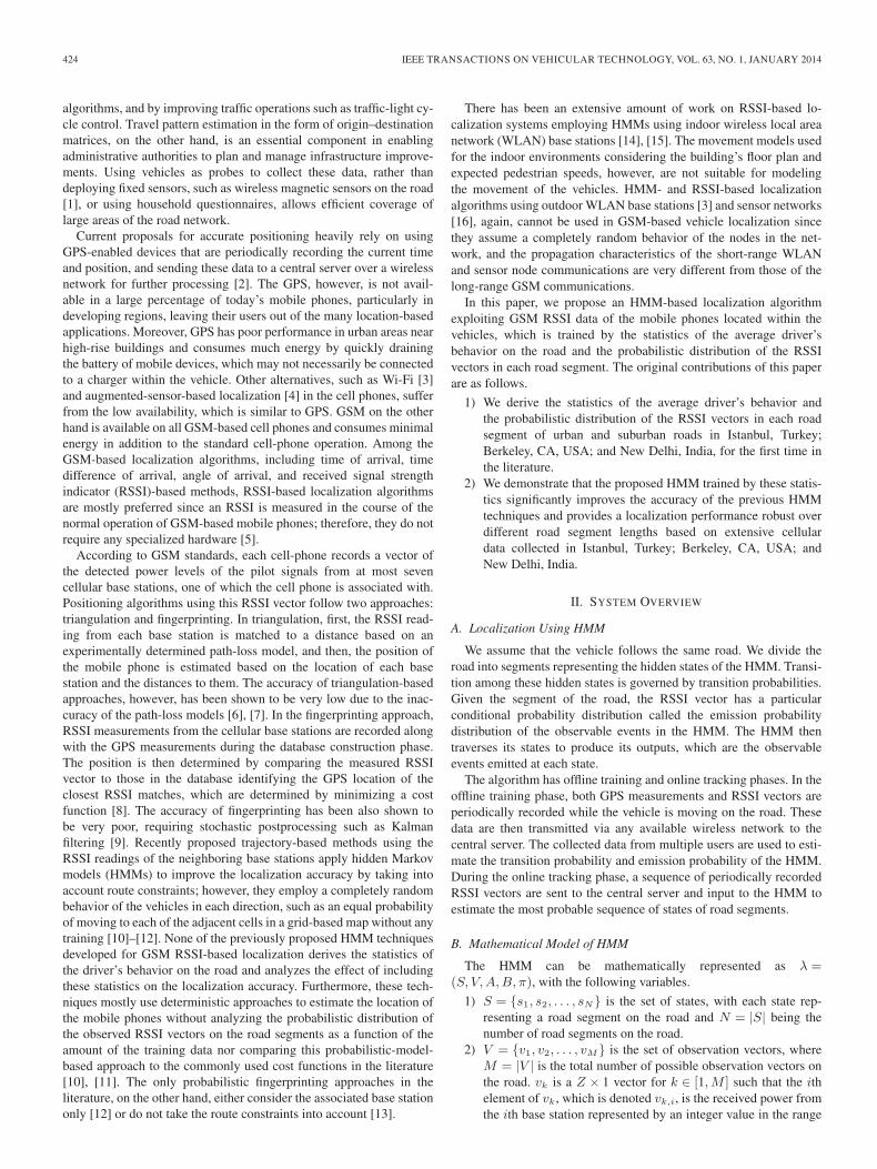
Fig. 1. (a) Urban road with a length of 12 km between Sariyer and 4. Levent, Istanbul, Turkey. (b) Suburban road with a length of 4 km between Koç Universityand Sariyer, Istanbul, Turkey. (c) Suburban road with a length of 8.2 km between the University of California, Berkeley, CA, USA and Temescal, Oakland, CA,USA, (d) Suburban road with a length of 2.9 km in New Delhi, India.
of [−110,−40] dBm if the ith base station is one of the sevenstrongest base stations and 0, otherwise, where Z is the totalnumber of base stations observed on the road.
3) A is an N ×N matrix such that the element in the ith row andthe jth column of A, which is denoted aij , is the probabilityof the transition from state si to state sj , i.e., aij = P (qn+1 =sj |qn = si), where qn is the state at time nτ , and τ is the sam-pling period. First, we assume that the vehicle follows the sameroad and that the training of the HMM is performed by usingthe data collected from the vehicles following that same road.This assumption eliminates the requirement for considering theeffect of the variation of the routes of different drivers to theirdestination. Second, we assume that the vehicles move with thesame average speed in the same direction along the road usedin the training and tracking phases, meaning that the transitionprobability aij is independent of the segment i but only dependson the difference between i and j, i.e., aij = ak, where k =j − i and ak = 0 for k < 0. Matrix A needs to be derived foreach road satisfying these conditions. This approach can begeneralized to general vehicle tracking, where different drivershave different routes to their destination by dividing the roadinto multiple segments where these assumptions hold. The firstnovelty of this paper is the derivation of ak values based on thetraining data summarizing the statistics of the average driver’sbehavior on the road. The previous HMM RSSI-based GSM lo-calization algorithms allow the transitions only to the current orfollowing road segments, i.e., a0 = 1/2 and a1 = 1/2 [10]–[12].
4) B is an N ×M matrix such that the element in the jth rowand the kth column of B, which is denoted bjk, is the emissionprobability of vk on the jth road segment corresponding to statesj , i.e., bjk = P (vk|sj). The emission probability distributionsderived for WLAN systems [3], [14], [15] and sensor networks[16] cannot be used for GSM systems due to their differentpropagation characteristics. The HMM techniques developed forGSM RSSI-based localization, on the other hand, use either adeterministic function of the Euclidean distance and the numberof matching base stations between the observed vector andeach RSSI vector in the training database as the cost of theobserved RSSI vector [11] or the histogram of the RSSI readingsof the associated base station in each road segment [12]. Thesecond novelty of this paper is proving that the histogram of theRSSI readings of each base station within each road segmentconverges to the Gaussian distribution if enough RSSI samplesare collected.
5) π is an N × 1 vector such that the ith element of π, whichis denoted πi, is the probability of state si initially, i.e., πi =P (q1 = si).
III. DATA COLLECTION
We collected data over four different roads shown in Fig. 1. The firstroad between Sariyer and 4. Levent, Istanbul, Turkey, with a length of12 km, shown in Fig. 1(a), represents an urban road in Istanbul. Thesecond road between Koç University and Sariyer, Istanbul, Turkey,with a length of 4 km, shown in Fig. 1(b), represents a suburbanroad in Istanbul. The third road between the University of California,Berkeley, CA, USA, and Temescal, Oakland, CA, USA, with a lengthof 8.2 km, shown in Fig. 1(c), represents a suburban road in the U.S.The fourth road in New Delhi, India, with a length of 2.9 km, shownin Fig. 1(d), represents a suburban road in India.
The monitoring device for collecting RSSI signatures was a standardNokia handset operating in the 900-MHz band and connected to alaptop that runs network monitoring software. A sample of the RSSIsignature containing the power levels and identifiers of the sevenstrongest base stations is reported once every 2 s along with the GPSlatitude and longitude information, i.e., τ = 2 s. Twenty test runsare performed at low-, medium-, and high-traffic conditions on theurban road in Istanbul, Turkey, shown in Fig. 1(a), whereas 20 testruns are performed on the suburban roads shown in Fig. 1(b)–(d)since the traffic conditions do not significantly change during theday, i.e., ten runs are used for training, and ten runs are used fortracking.
IV. ESTIMATION AND USAGE OF HIDDEN
MARKOV MODEL STATISTICS
A. Training Phase
During the training phase, GPS and RSSI vector data observedfrom the cell phones are collected at the central server to create thedatabase. The parameters of the HMM are then estimated using thisdatabase.
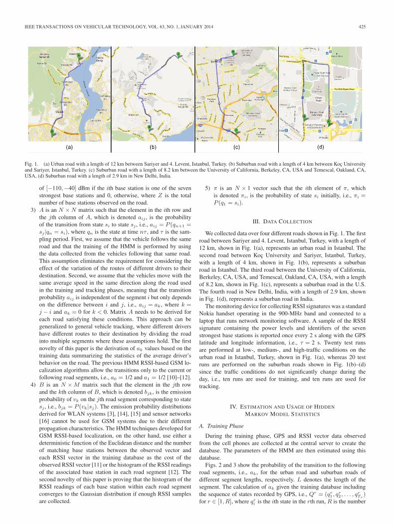
Figs. 2 and 3 show the probability of the transition to the followingroad segments, i.e., ak, for the urban road and suburban roads ofdifferent segment lengths, respectively. L denotes the length of thesegment. The calculation of ak given the training database includingthe sequence of states recorded by GPS, i.e., Qr = (qr1 , q
r2 , . . . , q
rTr)
for r ∈ [1, R], where qri is the ith state in the rth run, R is the number
426 IEEE TRANSACTIONS ON VEHICULAR TECHNOLOGY, VOL. 63, NO. 1, JANUARY 2014
Fig. 2. Probability of the transition to the following road segments at low-,medium-, and high-traffic conditions for the urban road of different segmentlengths.
Fig. 3. Probability of the transition to the following road segments for thesuburban roads of different segment lengths.
of runs in the training data, and Tr is the number of data pointscorresponding to the rth run in the training data, is given as
ak =
∑R
r=1
∑Tr−1
j=1δqr
j+1−qr
j,k∑R
r=1
∑Tr−1
j=11
(1)
where δqrj+1
−qrj,k is the Kronecker delta function that takes the value
of 1 if qrj+1 − qrj = k and 0, otherwise; the numerator is the number oftransitions of magnitude k; and the denominator is the total numberof transitions. We observe that the transition probability significantlyvaries depending on the location and traffic conditions of the roads,contradicting the common assumption of the HMM-based localizationliterature that the mobiles move only to the adjacent grid cells oradjacent road segments.
The analysis of many histograms of the observed RSSI values frommany base stations shows that the histogram has a Gaussian shapeif enough RSSI samples are collected from the base station in thecorresponding road segment. The number of RSSI samples requiredfor the Kolmogorov–Smirnov test, with a 95% confidence interval todecide for the Gaussian distribution of these RSSI samples, is less than30 in all the segments of different lengths over all the roads used forthe evaluation. (The Kolmogorov–Smirnov test is a nonparametric testfor the equality of continuous 1-D probability distributions comparinga sample distribution with a reference probability distribution).Thenumber of samples required to estimate the mean and variance of
the Gaussian distribution of the RSSI samples with 90% accuracyis around 30. Given that the number of samples collected from thesegment lengths that are greater than or equal to 10 m, which are usedin the evaluation of the algorithm, in each run of the training data ismore than 4, the total number of samples from ten runs of the trainingdata, i.e., 40 samples, will be enough to estimate the mean and varianceof the Gaussian distribution with 90% accuracy.
Let us denote the mean and variance of the best Gaussian fit tothe RSSI histogram of the ith base station at the jth road segmentcorresponding to state sj by mj,i and σ2
j,i, respectively. Recall thatbjk is the emission probability of an observation vector vk in state sj .Let us define the cost of observing vk in state sj , which is denoted cjk,as the normalized logarithm of bjk. Based on the assumption that thesamples from different base stations are independent, cjk is given by
cjk=1Zp
Z∑i=1,mj,i<0,vk,i>0
(−1
2ln(2π)−ln(σj,i)−
(vk,i−mj,i)2
2σ2j,i
)(2)
where Zp is the number of base stations for which both mj,i andvk,i are negative. This is very similar to the previously proposed costfunctions defined as the distance between RSSI vectors, as in [3] and[11], except the weighting factor as a function of the variance, givingless weight to the observation with high variance.
The sampling period τ , the segment length L, the road, and trafficconditions on the road affect the values of both the transition andemission probabilities, but the algorithm works as long as the sameτ and L values, the same road, and the same traffic conditions are usedin both the training and tracking phases.
B. Tracking Phase
During the tracking phase, the mobile phone only sends the RSSIvector information to the central server so that the server identifiesthe most likely sequence of the road segments traveled by the user,i.e., states Q = (q1, q2, . . . , qT ), given the sequence of the observedRSSI vectors, i.e., observations O = (O1, O2, . . . , OT ), where T isthe number of observations. Since the parameters of the HMM areestimated during the training phase, the Viterbi algorithm is used toestimate the most likely sequence of the road segments [17].
V. PERFORMANCE EVALUATION
A. Localization Error Comparison at Different Traffic Conditionsin Different Locations
Figs. 4 and 5 compare the accuracy of the proposed HMM-basedtechnique using the statistics of the driver and RSSI measurementsat each road segment, which is denoted S-HMM, with the previouslyproposed HMM technique called Ctrack [11] for urban and suburbanroads, respectively. Ctrack is actually developed as a two-pass HMM,which first determines a sequence of grid cells corresponding to aninput sequence of GSM fingerprints and then matches the grid cells toa road. The cost of the observed RSSI vector is a weighted functionof the Euclidean distance and the number of matching base stationsbetween the observed vector and each RSSI vector in the trainingdatabase. Ctrack assumes uniform transition probability from thecurrent grid cell to each of the adjacent cells and is adapted here for thelocalization on the road. We observe that the median localization errorfor Ctrack is very large for small and large segment lengths, whereasS-HMM has a stable localization error due to the inclusion of the driverand RSSI statistics. Moreover, the median error of S-HMM is smallerthan that of Ctrack for all segment lengths.
Fig. 6 shows the cumulative distribution function (cdf) of the local-ization error on the suburban road in Berkeley, CA, USA, for S-HMM,

IEEE TRANSACTIONS ON VEHICULAR TECHNOLOGY, VOL. 63, NO. 1, JANUARY 2014 427
Fig. 4. Comparison of the median error of the proposed S-HMM algorithmwith the previously proposed HMM technique called Ctrack at low-, medium-,and high-traffic conditions for the urban road.
Fig. 5. Comparison of the median error of the proposed S-HMM algorithmwith the previously proposed HMM technique called Ctrack for the suburbanroads in different locations: Istanbul, Turkey, Berkeley, CA, USA, and NewDelhi, India.
Ctrack, and a deterministic algorithm called K-nearest neighbor(KNN) [18]. In the KNN algorithm, all the collected RSSI vectors andthe corresponding GPS locations are stored during the training phase.During the tracking phase, the received RSSI vector at an unknownlocation is compared with all the RSSI vectors stored in the database,and its location is estimated as the average of the GPS locations of theK-closest RSSI vectors in terms of Euclidean distance. We observethat the localization error for S-HMM is always to the left of theCtrack and KNN algorithms for all the segment lengths. The cdf of thelocalization error for the urban road and suburban roads in Istanbul,Turkey, and in New Delhi, India exhibits a similar behavior.
B. Effect of Including Driver and RSSI Statistics
Fig. 7 shows the effect of including the driver and RSSI statisticson the localization error by comparing the performance of S-HMMto variations of S-HMM, including different transition probabilitiesand different cost functions for the urban road at medium traffic inIstanbul, Turkey. Since the behavior is similar for the other trafficconditions and locations, we did not include separate graphs for them.S-HMM uses driver and RSSI statistics to determine the transitionprobability matrix and emission probability of the HMM, respectively.“S-HMM w/ Ctrack cost” and “S-HMM w/ Manhattan cost” use
Fig. 6. CDF of the localization error of S-HMM, Ctrack, and KNN algorithmsfor the suburban road in Berkeley, CA, USA.
Fig. 7. Analysis of the effect of including the driver and RSSI statistics on thelocalization error for the urban road at medium traffic.
driver statistics to determine the transition probability matrix but usethe Ctrack cost function and the Manhattan cost for emission score,respectively. The Manhattan cost of the observed RSSI vector isdefined as the Manhattan distance between the observed vector andeach RSSI vector in the training database [8]. “S-HMM w/ equaltrans.prob.,” on the other hand, uses RSSI statistics to determine theemission probability but uses uniform transition probability to theadjacent segments. We observe that the Ctrack cost performs worstas the segment length increases, whereas the Manhattan cost is morestable but still performs worse than S-HMM. The cost function isthe main reason for the increase in the localization error of Ctrackas the segment length increases. When we compare S-HMM with“S-HMM w/ equal trans.prob.,” we see that the assumption of uniformdistribution for the transition probability is the main reason for thesteep increase in the localization error of Ctrack as the segment lengthdecreases. However, interestingly, the localization error of “S-HMMw/ equal trans.prob.” is smaller than that of S-HMM when the segmentlength is above 40 m. The main reason is that our implicit assumptionof memoryless transitions between road segments in determining thestatistics of the driver’s behavior loses validity as the segment lengthincreases. As the segment length increases, we may need to include thestate duration density in the HMM [19].
428 IEEE TRANSACTIONS ON VEHICULAR TECHNOLOGY, VOL. 63, NO. 1, JANUARY 2014
C. Energy Consumption Comparison
The cell phone is expected to operate in the tracking phase aftera short training period. The training can be also done by using somevoluntary mobile phones only. Since cell phones continuously trackbase stations as part of their normal operation, the marginal energy costof the tracking phase is driven by the CPU load to process base stationsignatures and to send this information to the central server. Processinga cell tower signature might require at most 100 000 instructions,which costs at most 30 μJ on an ARM Cortex-A8 processor. Theenergy required to send the packets depends on how frequently the dataare uploaded to the central server. A negligible amount of additionalpower is consumed if the collected data are compressed using simplegzip compression and are sent every minute [11]. Acquiring cell-phonesignatures with a period of 2 s therefore results in power consumptionof 15 μW. The power consumption of GPS on the other hand ismeasured to be around 400 mW [11], which is several orders largerthan that of the GSM-based localization.
VI. CONCLUSION
In this paper, we have proposed a statistical fingerprinting approachto position a mobile device that follows any predetermined routeby using RSSI measurements recorded from at most seven cellularbase stations in the course of the normal operation of GSM-basedmobile phones with minimal energy consumption. We incorporate theroute constraint for the motion of the vehicles by using an HMM.We demonstrate that training the HMM based on the average driverstatistics on the road and the probabilistic distribution of the RSSI vec-tors in each road segment considerably improves the accuracy of thepreviously proposed HMM-based techniques and provides localizationperformance robust over different segment lengths by using extensivecellular data collected in Istanbul, Turkey; Berkeley, CA, USA; andNew Delhi, India.
REFERENCES
[1] S. Cheung, S. Coleri, B. Dundar, S. Ganesh, C. Tan, and P. Varaiya,“Traffic measurement and vehicle classification with a single magneticsensor,” J. Transp. Res. Rec., no. 1917, pp. 173–181, Feb. 2006.
[2] J. Herrera, D. Work, X. Ban, R. Herring, Q. Jacobson, and A. Bayen,“Evaluation of traffic data obtained via gps-enabled mobile phones:The mobile century field experiment,” Transp. Res. C, Emerg. Technol.,vol. 18, no. 6, pp. 568–583, Aug. 2010.
[3] A. Thiagarajan, L. Sivalingam, K. LaCurts, S. Toledo, J. Eriksson,S. Madden, and H. Balakrishnan, “Vtrack: Accurate, energy-aware roadtraffic delay estimation using mobile phones,” in Proc. ACM Sensys,Nov. 2009, pp. 85–98.
[4] I. Constandache, R. R. Choudhury, and I. Rhee, “Towards mobile phonelocalization without war-driving,” in Proc. IEEE INFOCOM, Mar. 2010,pp. 1–9.
[5] M. Porretta, P. Nepa, G. Manara, and F. Giannetti, “Location, location,location,” IEEE Veh. Technol. Mag., vol. 3, no. 2, pp. 20–29, Jun. 2008.
[6] A. Weiss, “On the accuracy of a cellular location system based on RSSmeasurements,” IEEE Trans. Veh. Technol., vol. 52, no. 6, pp. 1508–1518,Nov. 2003.
[7] N. Ghaboosi and A. Jamalipour, “The geometry of overhearing and itsapplication for location estimation in cellular networks,” IEEE Trans. Veh.Technol., vol. 60, no. 7, pp. 3324–3331, Sep. 2011.
[8] A. Arya, P. Godlewski, and P. Melle, “Performance analysis of outdoorlocalization systems based on rss fingerprinting,” in Proc. 6th ISWCS,Sep. 2009, pp. 378–382.
[9] C. Takenga, T. Peng, and K. Kyamakya, “Post-processing of fingerprintlocalization using Kalman filter and map-matching techniques,” in Proc.9th Int. Conf. Adv. Commun. Technol., Feb. 2007, pp. 2029–2034.
[10] T. Stamoulakatos, A. Markopoulos, M. Anagnostou, and M. Theologou,“Vehicle velocity estimation based on rss measurements,” Wireless Pers.Commun., vol. 40, no. 4, pp. 523–538, Mar. 2007.
[11] A. Thiagarajan, L. S. Ravindranath, H. Balakrishnan, S. Madden, andL. Girod, “Accurate, low-energy trajectory mapping for mobile devices,”in Proc. 8th USENIX Symp. NSDI, Mar. 2011, p. 20.
[12] M. Ibrahim and M. Youssef, “A hidden Markov model for localizationusing low-end GSM cell phones,” in Proc. IEEE ICC, Jun. 2011, pp. 1–5.
[13] M. Ibrahim and M. Youssef, “Cellsense: An accurate energy-efficientGSM positioning system,” IEEE Trans. Veh. Technol., vol. 61, no. 1,pp. 286–296, Jan. 2012.
[14] J. Krumm and E. Horvitz, “LOCADIO: Inferring motion and locationfrom Wi-Fi signal strengths,” in Proc. 1st Annu. Int. Conf. MOBIQUI-TOUS Syst., Netw. Services, Aug. 2004, pp. 4–13.
[15] L. Kung-Chung and L. Lampe, “Indoor cell-level localization based onRSSI classification,” in Proc. 24th CCECE, May 2011, pp. 21–26.
[16] R. Arthi and K. Murugan, “Localization in wireless sensor networks byhidden Markov model,” in Proc. 2nd ICoAC, Dec. 2010, pp. 14–18.
[17] A. Viterbi, “Error bounds for convolutional codes and an asymptoticallyoptimum decoding algorithm,” IEEE Trans. Inf. Theory, vol. IT-13, no. 2,pp. 260–269, Apr. 1967.
[18] M. Y. Chen, T. Sohn, D. Chmelev, D. Haehnel, J. Hightower, J. Hughes,A. LaMarca1, F. Potter, I. Smith, and A. Varshavsky, “Practicalmetropolitan-scale positioning for GSM phones,” in Proc. Int. Conf.UbiComp, Sep. 2006, pp. 225–242.
[19] L. Rabiner, “A tutorial on hidden Markov models and selected applica-tions in speech recognition,” Proc. IEEE, vol. 77, no. 2, pp. 257–286,Feb. 1989.
Energy-Efficient Water-Filling with Order Statistics
Ismael Gomez-Miguelez, Vuk Marojevic, and Antoni Gelonch
Abstract—This paper proposes a methodology based on order statisticsto study the energy-efficient (EE) power allocation for wireless communi-cation transmitters. Water-filling power allocation maximizes the EE whentransmitting and processing power consumption is considered. Solutionsare typically presented in an iterative form, which complicates analysisand adaptive implementation. Time-consuming simulations are ratherrequired to assess their performance. Order statistics allows analyzingthe solution without knowledge of the channel realization. We analyticallyshow how the EE depends on the system parameters. The computing effi-ciency of our proposal, which is executing one or two orders of magnitudefaster than the state-of-the-art algorithms with a performance loss of lessthan 1 dB, facilitates its applicability in vehicular environments.
Index Terms—Energy efficiency (EE), link adaptation, ordered statis-tics, water-filling.
I. INTRODUCTION
The energy consumption of wireless communications networkscontributes to the escalation of the greenhouse effect, which hasbeen recognized as a major threat to environmental protection andsustainable development. Sophisticated data services and the always-on concept of battery-operated systems impose significant energy man-agement challenges. Energy-efficient (EE) transmission architecturesand technologies are therefore needed for mobile terminals and basestations alike.
Manuscript received February 9, 2013; revised April 24, 2013; acceptedMay 28, 2013. Date of publication June 28, 2013; date of current versionJanuary 13, 2014. This work was supported by the Spanish Ministry ofEconomy and Competitiveness under Project TEC2011-29126-C03-02. Thereview of this paper was coordinated by Dr. C. Yuen.
The authors are with the Department of Signal Theory and Communications,Technical University of Catalonia, Barcelona 08034, Spain (e-mail: [email protected]; [email protected]; [email protected]).
Color versions of one or more of the figures in this paper are available onlineat http://ieeexplore.ieee.org.
Digital Object Identifier 10.1109/TVT.2013.2271647
0018-9545 © 2013 IEEE. Personal use is permitted, but republication/redistribution requires IEEE permission.See http://www.ieee.org/publications_standards/publications/rights/index.html for more information.