Overview€¦ · Web viewSpatial data are expressed as latitude (φ) and longitude (λ)...
54
INTERNATIONAL HYDROGRAPHIC ORGANIZATION IHO GEOSPATIAL STANDARD FOR NAVIGATIONAL WARNINGS Working Draft – Edition 0.0.1 2018-10-31 Special Publication No. S-124 Navigational Warnings - Product Specification Published by the International Hydrographic Organization MONACO 1
Transcript of Overview€¦ · Web viewSpatial data are expressed as latitude (φ) and longitude (λ)...
INTERNATIONAL HYDROGRAPHIC ORGANIZATION
IHO GEOSPATIAL STANDARDFOR NAVIGATIONAL WARNINGS
Working Draft – Edition 0.0.1
2018-10-31
Special Publication No. S-124
Navigational Warnings - Product Specification
Published by the International Hydrographic Organization
MONACO
1

Revision HistoryChanges to this Product Specification are coordinated by the IHO World-Wide Navigational Warning Service Sub-Committee (WWNWS-SC). New editions will be made available via the IHO web site. Maintenance of the Product Specification shall conform to IHO Technical Resolution 2/2007 (revised 2010).
Version Number Date Author Purpose0.0.1 2018-05-31 EM Initial draft
0.0.1 2018-06-13 EM Edits following SHOM comments
0.0.2 2018-10-31 EM Implementing decisions of WWNWS10
2

Contents1 Overview......................................................................................................................................................... 5
1.1 INTRODUCTION...................................................................................................................................... 5
2 References..................................................................................................................................................... 62.1 NORMATIVE........................................................................................................................................... 6
3 Terms, Definitions and Abbreviations.........................................................................................................63.1 TERMS AND DEFINITIONS ...................................................................................................................... 63.2 ABBREVIATIONS .................................................................................................................................... 93.3 USE OF LANGUAGE................................................................................................................................ 93.4 UML NOTATIONS................................................................................................................................... 9
4 Overview....................................................................................................................................................... 104.1 SPECIFICATION DESCRIPTION...............................................................................................................104.2 DATA PRODUCT SPECIFICATION METADATA............................................................................................104.3 PRODUCT SPECIFICATION MAINTENANCE..............................................................................................11
4.3.1 Introduction........................................................................................................................... 114.3.2 New Edition........................................................................................................................... 114.3.3 Revisions............................................................................................................................... 114.3.4 Clarification........................................................................................................................... 124.3.5 Version Numbers..................................................................................................................12
4.4 SPECIFICATION SCOPE........................................................................................................................ 12
5 Data product identification.........................................................................................................................126 Data Content and Structure........................................................................................................................ 137 Feature Catalogue....................................................................................................................................... 17
7.1.1 Introduction........................................................................................................................... 177.2 FEATURE TYPES.................................................................................................................................. 18
7.2.1 Geographic............................................................................................................................ 187.2.2 Feature Relationship.............................................................................................................187.2.3 Information Types.................................................................................................................. 187.2.4 Information Relationship........................................................................................................187.2.5 Attributes............................................................................................................................... 18
7.3 UNITS OF MEASURE............................................................................................................................. 207.4 GEOMETRIC REPRESENTATION.............................................................................................................20
8 Coordinate Reference System (CRS).........................................................................................................218.1 INTRODUCTION.................................................................................................................................... 218.2 HORIZONTAL REFERENCE SYSTEM........................................................................................................228.3 PROJECTION....................................................................................................................................... 228.4 VERTICAL COORDINATE REFERENCE SYSTEM........................................................................................228.5 TEMPORAL REFERENCE SYSTEM...........................................................................................................22
9 Data Quality.................................................................................................................................................. 229.1 INTRODUCTION.................................................................................................................................... 22
10 Data Capture and Classification.............................................................................................................2310.1 DATA ENCODING AND PRODUCT DELIVERY.......................................................................................23
10.1.1 Data Encoding....................................................................................................................... 2310.1.2 Types of Datasets.................................................................................................................2310.1.3 Content of Datasets...............................................................................................................2410.1.4 In-force bulletin dataset.........................................................................................................2410.1.5 No message on hand............................................................................................................24
10.2 ENCODING OF LATITUDE AND LONGITUDE..........................................................................................24
3

10.2.1 Encoding of coordinates as decimals....................................................................................2410.3 NUMERIC ATTRIBUTE ENCODING.......................................................................................................2510.4 TEXT ATTRIBUTE VALUES................................................................................................................. 2510.5 MANDATORY ATTRIBUTE VALUES......................................................................................................2510.6 UNKNOWN ATTRIBUTE VALUES.........................................................................................................2510.7 STRUCTURE OF DATASET FILES.........................................................................................................25
10.7.1 Sequence of objects..............................................................................................................2510.8 OBJECT IDENTIFIERS........................................................................................................................ 2610.9 DATA COVERAGE............................................................................................................................. 2610.10 DATA OVERLAP................................................................................................................................ 2610.11 DATA QUALITY................................................................................................................................. 2610.12 USE OF DATASETS........................................................................................................................... 2710.13 SCALE IN S-124 DATASETS..............................................................................................................2710.14 FILTERING NAVIGATIONAL WARNING INFORMATION............................................................................27
11 Data Delivery............................................................................................................................................ 2711.1 DATA PRODUCT DELIVERY INFORMATION..............................................................................................2711.2 DATASET LOADING............................................................................................................................... 27
11.2.1 Use of S-124 in ECDIS..........................................................................................................2811.2.2 Section for producer Technical service.................................................................................2811.2.3 Section for push broadcast systems using the producer TS (radio stations …)...................28
11.3 IN-FORCE BULLETIN............................................................................................................................. 2811.4 DATASET CANCELLATION...................................................................................................................... 2911.5 UPDATING DATASETS........................................................................................................................... 2911.6 EXCHANGE SET................................................................................................................................... 2911.7 DATASET SIZE..................................................................................................................................... 3011.8 SUPPORT FILES................................................................................................................................... 3011.9 DATASET NAMING CONVENTION...........................................................................................................3011.10 CATALOGUE FILE NAMING CONVENTION............................................................................................31
12 Data Maintenance..................................................................................................................................... 3112.1 INTRODUCTION................................................................................................................................. 3112.2 PRODUCTION PROCESS FOR BASE AND UPDATE DATASETS.................................................................3112.3 INFORMATION UPDATES.................................................................................................................... 3112.4 SUPPORT FILE UPDATES................................................................................................................... 3112.5 FEATURE AND PORTRAYAL CATALOGUES...........................................................................................32
13 Portrayal................................................................................................................................................... 3314 Metadata................................................................................................................................................... 34
14.1 INTRODUCTION................................................................................................................................. 3414.2 DATASET METADATA........................................................................................................................ 3614.3 SUPPORT FILE METADATA................................................................................................................3714.4 EXCHANGE SET METADATA..............................................................................................................39
14.4.1 Catalogue File Metadata.......................................................................................................39
Appendix A. Data Capture and Encoding Guide..............................................................................................40Appendix C. Feature Catalogue.........................................................................................................................41Appendix D-1. GML Data Format Overview......................................................................................................42Appendix E. Validation Checks.........................................................................................................................43Appendix F. Portrayal Catalogue......................................................................................................................44
4

1 Overview1.1 IntroductionThis document has been produced by the IHO World-Wide Navigational Warning ServiceSub-Committee (WWNWS-SC). The purpose of this document is to respond to requests to produce a data product that can be used in a Navigational Warning Information Overlay (NWIO) within an Electronic Chart Display and Information Systems (ECDIS). It is based on the IHO S-100 framework specification and the ISO 19100 series of standards. It is a vector product specification that is primarily intended for encoding the nature and extent of Navigational Warnings, for navigational purposes.
S-124 Navigational Warning is based on the guidelines set forth for navigational warnings in the Joint IHO/IMO/WMO Manual on Maritime Safety Information (MSI), IHO Publication S-53. It should be noted that although S-53 covers spectrum of MSI, S-124 focuses only on Navigational Warnings.
S-124 has been designed to permit utilization of S-124 datasets in creating Navigational Warnings for traditional Radio Broadcast, NAVTEX and SafetyNET messages. This design feature aims to permit a greater sense of backwards compatibility, allowing production systems to share the same information in multiple channels for the greatest possible dispersion of safety critical navigational information.
S-124 Navigational Warnings are intended to be used in an overlay to ENC within a navigation system.
5

2 References2.1 NormativeThe following normative documents contain provisions that, through reference in this text, constitute provisions of this document.
IHO/IMO/WMO S-53 Joint IHO/IMO/WMO Manual on Maritime Safety Information (MSI) January 2016 Edition
IHO S-100 IHO Universal Hydrographic Data Model Edition 4.0.0 (Release date is TBD).
ISO 8601. 2004. Data elements and interchange formates - Information interchange - Representation of dates and times. 2004.
ISO 3166-1. 1997. Country Codes. 1997.
ISO 19101-2:2008 Geographic Information - Rules for Application Schema
ISO/TS 19103:2005 Geographic Information - Conceptual schema language
ISO 19106:2004 Geographic Information - Profiles
ISO 19109:2005 Geographic Information - Rules for Application Schema
ISO 19111:2003 Geographic information - Spatial referencing by coordinates
ISO 19115:2015 Geographic information - Metadata
ISO 19131:2007 Geographic information - Data product specifications
3 Terms, Definitions and Abbreviations
3.1 Terms and Definitions
The S-100 framework is based on the ISO 19100 series of geographic standards. The terms and definitions provided here are used to standardize the nomenclature found within that framework, whenever possible. They are taken from the references cited in clause 2.1. Modifications have been made when necessary.
application
manipulation and processing of data in support of user requirements (ISO 19101)
application schema
conceptual schema for data required by one or more applications (ISO 19101)
conceptual model
model that defines concepts of a universe of discourse (ISO 19101)
conceptual schema
6
Eivind Mong, 2018-10-17,
To be reviewed when document is closer to finalized.

formal description of a conceptual model (ISO 19101)
data product
dataset or dataset series that conforms to a data product specification
data product specification
detailed description of a dataset or dataset series together with additional information that will enable it to be created, supplied to and used by another partyNOTE: A data product specification provides a description of the universe of discourse and a specification for mapping the universe of discourse to a dataset. It may be used for production, sales, end-use or other purpose.
dataset
identifiable collection of data (ISO 19115)NOTE: A dataset may be a smaller grouping of data which, though limited by some constraint such as spatial extent or feature type, is located physically within a larger dataset. Theoretically, a dataset may be as small as a single feature or feature attribute contained within a larger dataset. A hardcopy map or chart may be considered a dataset.
dataset series
collection of datasets sharing the same product specification (ISO 19115). Distinction: series
domain
well-defined set (ISO/TS 19103)NOTE: Well-defined means that the definition is both necessary and sufficient, as everything that satisfies the definition is in the set and everything that does not satisfy the definition is necessarily outside the set.
exchange set
datasets may be grouped into exchange sets. Each exchange set consists of one or more datasets with an associated XML metadata file and a single Exchange Catalogue XML file containing metadata. It may also include one or more support files.
feature
abstraction of real world phenomena (ISO 19101)NOTE: A feature may occur as a type or an instance. Feature type or feature instance shall be used when only one is meant.
feature association
7

relationship that links instances of one feature type with instances of the same or a different feature type (ISO19110)NOTE 1; A feature association may occur as a type or an instance. Feature association type or feature association instance is used when only one is meant.NOTE 2: Feature associations include aggregation of features.
feature attribute
characteristic of a feature (ISO 19101)NOTE 1: A feature attribute may occur as a type or an instance. Feature attribute type or feature attribute instance is used when only one is meant.NOTE 2: A feature attribute type has a name, a data type and a domain associated to it. A feature attribute for a feature instance has an attribute value taken from the domain.
geographic data
data with implicit or explicit reference to a location relative to the Earth (ISO 19109)NOTE: Geographic information is also used as a term for information concerning phenomena implicitly or explicitly associated with a location relative to the Earth.
In-force bulletin
a list of serial numbers of those NAVAREA, Sub-area or coastal warnings in force issued and broadcast by the NAVAREA Coordinator, Sub-area Coordinator or National Coordinator. NOTE: S-124 also includes local warnings in-force bulletin.
metadata
data about data (ISO 19115)
model
abstraction of some aspects of reality (ISO 19109)
navigational warning
Navigational warning means a message containing urgent information relevant to safe navigation broadcast to ships in accordance with the provisions of the International Convention for the Safety of Life at Sea, 1974, as amended.
portrayal
presentation of information to humans (ISO 19117)
quality
totality of characteristics of a product that bear on its ability to satisfy stated and implied needs (ISO 19101)
serie
8

A series is a numbered sequence of navigational warnings of the same type (NAVAREA, sub-area, coastal or local) issued by an authority acting as official production agency”. Rem: S-53 identifies NAVAREA coordinator, sub-Area coordinator, national coordinator for coastal warnings. As local warnings are out of the scope of S-53, the term of “coordinators” is not used for local warnings.
universe of discourse
view of the real or hypothetical world that includes everything of interest (ISO 19101)
3.2 Abbreviations
This product specification adopts the following convention for symbols and abbreviated terms:ECDIS Electronic Chart Display and Information SystemsENC Electronic Navigational ChartGMDSS Global Maritime Distress and Safety SystemGML Geography Markup LanguageIHO International Hydrographic OrganizationIOC International Oceanographic CommissionISO International Organization for StandardizationMIO Marine Information OverlayMRN Maritime Resource NameNWIO Navigational Warning Information OverlayUML Unified Modelling LanguageURI Uniformed Resource IdentifierURL Uniform Resource LocatorURN Uniform Resource NameWMS Web Map ServiceWFS Web Feature ServiceWWNWS World-Wide Navigational Warning Service, part of the maritime safety information
service of the GMDSSWWNWS-SC IHO World-Wide Navigational Warning Service Sub-Committeewww World Wide WebWGS World Geodetic SystemXML Extensible Markup LanguageXSLT eXtensible Stylesheet Language Transformations
3.3 Use of LanguageWithin this document, including appendices and annexes:
• “Must” indicates a mandatory requirement.• “Should” indicates an optional requirement, that is the recommended process to be
followed, but is not mandatory.• “May” means “allowed to” or “could possibly”, and is not mandatory.
3.4 UML Notations
9
Eivind Mong, 2018-10-17,
To be reviewed when document is closer to finalized.

In this document, conceptual schemas are presented in the Unified Modelling Language (UML). Several model elements used in this schema are defined in ISO standards or in IHO S-100 documents. In order to ensure that class names in the model are unique ISO TC/211 has adopted a convention of establishing a prefix to the names of classes that define the TC/211 defined UML package in which the UML class is defined. Since the IHO standards and this product specification make use of classes derived directly from the ISO standards. This convention is also followed in this document. In the IHO standards class names are identified by the name of the standard, such as "S100" as the prefix optionally followed by the bi-alpha prefix derived from ISO standard. For the classes defined in this product specification the prefix is "S124". In order to avoid having multiple classes instantiating the same root classes, the ISO classes and S-100 classes have been used where possible; however, a new instantiated class is required if there is a need to alter a class or relationship to prevent a reverse coupling between the model elements introduced in this document and those defined in S-100 or the ISO model.
4 Overview4.1 Specification Description
Title: Navigational Warnings Product Specification.
Abstract: This specification is developed for creating datasets containing navigational warning information primarily targeting use in ECDIS. Navigational warning means a message containing urgent information relevant to safe navigation broadcast to ships in accordance with the provisions of the International Convention for the Safety of Life at Sea,1974, as amended (S-53, 2.2.1.23). Use of Navigational Warning datasets in other systems than ECDIS is permitted.
Content: A dataset conforming to this specification will contain all relevant information of an individual Navigational Warning. Datasets of a series are delivered by means of an exchange set. Additionally there will be relevant metadata about data quality, production authority, and publication date.
Spatial Extent: Global coverage of maritime areas.
Specific Purpose: The purpose of this document is to respond to requests to produce a data product that can be used in a Navigational Warning Information Overlay (NWIO) within an Electronic Chart Display and Information Systems (ECDIS). It is based on the IHO S-100 framework specification and the ISO 19100 series of standards. It is a vector product specification that is primarily intended for encoding the extent and nature of Navigational Warnings, for navigational purposes.
4.2 Data product specification metadata
10
Eivind Mong, 2018-10-17,
confirm later if there will be any

This information uniquely identifies this Product Specification and provides information about its creation and maintenance. For further information on dataset metadata see the metadata clause.
Title: Navigational Warning
S-100 Version: 4.0.0
S-124 Version: Working Draft 0.0.1
Date: 2018-07-31
Language: English
Classification: Unclassified
Contact: International Hydrographic Bureau, 4 quai Antoine 1er,B.P. 445MC 98011 MONACO CEDEXTelephone: +377 93 10 81 00Telefax: + 377 93 10 81 40
URL: http://www.iho.int/mtg_docs/....
Identifier: S-124
Maintenance: Amendments to this specification will be produced on a needs basis. For reporting issues with this specification which need correction, use the contact information.
4.3 Product Specification Maintenance4.3.1 Introduction
Changes to S-124 will be released by the IHO as a new edition, a revision, or as a document that includes clarification. These are described below.
4.3.2 New EditionNew Editions introduce significant changes. New Editions enable new concepts, such as the ability to support new functions or applications, or the introduction of new constructs or data types. New Editions are likely to have a significant impact on either existing users or future users of S-124.
4.3.3 RevisionsRevisions are defined as substantive semantic changes. Typically, revisions will introduce change to correct factual errors; introduce necessary changes that have become evident as a result of practical experience or changing circumstances. A revision must not be classified as a clarification. Revisions could have an impact on either existing users or future users this
11

specification. All cumulative clarifications will be included with the release of approved corrections revisions.
Changes in a revision are minor and ensure backward compatibility with the previous versions within the same Edition. Newer revisions, for example, introduce new features and attributes. Within the same Edition, a dataset of one version could always be processed with a later version of the feature and portrayal catalogues. In most cases a new feature or portrayal catalogue will result in a revision of this specification.
4.3.4 ClarificationClarifications are non-substantive changes. Typically, clarifications: remove ambiguity; correct grammatical and spelling errors; amend or update cross references; insert improved graphics in spelling, punctuation and grammar. Clarification must not cause any substantive semantic changes.
Changes in a clarification are minor and ensure backward compatibility with the previous versions within the same Edition. Within the same Edition, a dataset of one clarification version could always be processed with a later version of the feature and portrayal catalogues, and a portrayal catalogue can always rely on earlier versions of the feature catalogues.
Changes in a clarification are minor and ensure backward compatibility with the previous versions.
4.3.5 Version NumbersThe associated version control numbering to identify changes (n) to this specification must be as follows:
New Editions denoted as n.0.0Revisions denoted as n.n.0Clarifications denoted as n.n.n
4.4 Specification Scope
This product specification describes one data product and therefore requires only one scope which is described below:
Scope ID: Navigational Warning datasets.
Hierarchical level: MD_ScopeCode - 005
Hierarchical level name: dataset.
Level description: information applies to the dataset
Extent: EX_Extent.description: Global coverage of maritime areas
5 Data product identification
12

title Navigational Warning
abstract Navigational Warning dataset is a vector dataset containing the extent and nature of Navigational Warnings, for navigational purposes.
acronym NW
content Navigational Warning information, such as characteristics of the Navigational Warning, new dangers, restrictions and regulations that require special attention.
spatialExtent Description: Global
East Bounding Longitude: -180West Bounding Longitude: 180North Bounding Latitude: 90South Bounding Latitude: -90
temporalExtent Datasets are valid till cancellation date or cancellation message, whichever comes first.
specificPurpose Navigational Warning datasets are produced for navigational purposes within an ECDIS, and to allow the producer or issuer to exchange NW information with navigators.
6 Data Content and Structure[To be done when data model is finalized]
13
Yves Le Franc, DTRI/CTRI, 2018-10-17,
Should be reviewed when the maintenance process will be defined.

class S-124 Navigational Warning Features and Information types
«FeatureType»S-124 Abstract Types::S124_FeatureType
«SpatialAttribute»+ areaAffected: PointCurveOrSurface [0..*]+ geometry: PointCurveOrSurface [0..*]
«ComplexAttribute»+ featureName: featureName [0..*]+ featureReference: S124_featureReference [0..*]+ fixedDateRange: S124_fixedDateRange [0..*] {ordered}
«SimpleAttribute»+ restriction: restriction [0..1]+ S124_warningHazardType: S124_warningHazardType [1..*] {ordered}
«FeatureType»S-124 Domain Model::S124_NavigationalWarningFeaturePart
«SimpleAttribute»+ warningInformation: S124_warningInformation [1..*]
«InformationType»S-124 Domain Model::S124_NWPreamble
«ComplexAttribute»+ generalArea: S124_locality [1..*] {ordered}
constraints{exactly 1 instance per dataset}
S124_InformationType
«InformationType»S-124 Abstract Types::S124_Preamble
«ComplexAttribute»+ locality: S124_locality [0..*] {ordered}+ messageSeriesIdentifier: S124_messageSeriesIdentifier+ S124_affectedChartPublications: S124_affectedChartPublications [0..*]+ title: title [0..*]
«SimpleAttribute»+ S124_cancellationDate: dateTime [0..1]+ S124_publicationDate: dateTime
S124_InformationType
«InformationType»S-124 Domain Model::S124_References
«ComplexAttribute»+ messageSeriesIdentifier: S124_messageSeriesIdentifier [0..*]
«SimpleAttribute»+ noMessageOnHand: Boolean+ referenceCategory: S124_referenceCategory
constraints{If noMessageOnHand=true, then messageSeriesIdentifier is prohibited}{if noMessageOnHand=false, then messageSeriesIdentifier is mandatory}
«FeatureType»S-124 Domain Model::S124_TextPlacement
«SimpleAttribute»+ flipBearing: real [0..1]+ scaleMinimum: integer [0..1]+ text: text+ textJustification: textJustification
«SpatialAttribute»+ geometry: GM_Point
+cartographicText
0..*
TextAssociation
+identifies
+header
NWPreambleContent
+theWarningPart 0..*{ordered}
+theReferences 0..*
NWReferences
+theWarning
Figure 6.1 - S-124 Features and Info Types
14

class S-124 Domain Objects v2
«FeatureType»S124_FeatureType
«SpatialAttribute»+ areaAffected: PointCurveOrSurface [0..*]+ geometry: PointCurveOrSurface [0..*]
«ComplexAttribute»+ featureName: featureName [0..*]+ featureReference: S124_featureReference [0..*]+ fixedDateRange: S124_fixedDateRange [0..*] {ordered}
«SimpleAttribute»+ restriction: restriction [0..1]+ S124_warningHazardType: S124_warningHazardType [1..*] {ordered}
«FeatureType»S124_NavigationalWarningFeaturePart
«SimpleAttribute»+ warningInformation: S124_warningInformation [1..*]
«ComplexAttributeType»S124_graphic
«SimpleAttribute»+ pictorialRepresentation: text+ pictureCaption: title [0..1]+ pictureInformation: title [0..1]+ sourceDate: Date [0..1]
«ComplexAttribute»+ pictureCaptionOtherLanguage: pictureCaptionOtherLanguage [0..*]+ pictureInformationOtherLanguage: pictureInformationOtherLanguage [0..*]
«InformationType»S124_InformationType
«S100_CodeList»S124_warningHazardType
«enum»+ acoustic recorder+ aids to navigation+ AIS surveillance systems+ anti pollution exercises+ anti pollution operations+ aquaculture site+ breakwater construction+ buoy adrift+ buoys+ cable laying operations+ cluster of fishing vessels+ container adrift+ dangerous wreck+ dead whale adrift+ deadhead adrift+ derelict vessel adrift+ DGPS+ diving operations+ dredging operations+ drifting hazard (other)+ drill rig on location+ drill rig under tow+ drilling site operations+ exclusion zones+ explosive detonation+ explosive device+ fallout hazard+ fireworks+ firing exercises+ fish-net adrift+ floating debris+ floating dock+ hazardous area+ HF Services+ hydrographic survey+ ice boom+ ice control zone in-force/deactivated+ iceberg outside advertised limits+ in-force bulletin+ lights & fog signals+ log boom adrift+ marine mammals+ maritime security - MARSEC level changes+ MF Services+ military exercises+ military operations+ mines+ MSI Services+ mussel farm+ national health organizations - changes+ nautical information issues+ NAVTEX+ newly discovered dangers+ offshore structures+ opening/closing of harbour+ opening/closing of swing bridge+ opening/closing of waterway+ operating anomalies identified within ECDIS including ENC issues+ pipe laying operations+ pipe or cable laying operations+ piracy+ race+ RACON+ radar surveillance systems+ radio navigation services+ regatta+ regulations+ research or scientific operations+ restricted area+ routeing Measures+ SafetyNET+ sandspit+ SAR and anti pollution operations+ SAR operations+ scientific buoy & apparatus+ scientific moorings+ scientific survey+ sea trials+ seaplane operations+ search and rescue exercises+ seasonal buoy lifting+ seasonal buoy placing+ seasonal buoy program+ security-related requirements+ seismic surveys+ shallow depth reported+ shoal+ submerged fish-net+ submerged object+ subsurface moorings+ subsurface pipelines+ survey results+ swimmers+ tide gauges+ traffic congestion+ tsunami warning+ tsunamis and other natural phenomena+ uncharted rock+ uncharted submarine cables+ underwater operations+ unidentified radar target, possible iceberg+ unwieldy tow+ vertical clearance reduced+ vessel adrift+ vessel disabled+ VHF Services+ VTS limit change+ water levels changed/not as advertised+ waterway recommended/not recommended for shipping+ wharf construction+ works in progress+ World Health Organization (WHO) health advisory information
tagscodelistType = open enumerationencoding = other: [something]
«ComplexAttributeType»S124_fixedDateRange
«SimpleAttribute»+ dateEnd: S100_TruncatedDate [0..1]+ dateStart: S100_TruncatedDate [0..1]+ timeOfDayEnd: Time [0..1]+ timeOfDayStart: Time [0..1]
constraints{timeOfDayStart can only be present if dateStart is also present}{timeOfDayEnd can only be present if dateEnd is also present}
«enumeration»restriction
entry restricted = 8 entry prohibited = 7 area to be avoided = 14 stopping prohibited = 25 speed restricted = 27
Should drive portrayal of central symbol.For localization of datasets, should be encoded as a code (or key) instead of plain text.[WWNWS10 decided to only have one symbol]
«ComplexAttributeType»information
«SimpleAttribute»+ fileLocator: text [0..1]+ fileReference: text [0..1]+ headline: text [0..1]+ language: ISO639-3 [0..1]+ text: text [0..1]
«ComplexAttributeType»S124_affectedChartPublications
«SimpleAttribute»+ chartAffected: S124_chartAffected [0..1]+ chartPublicationIdentifier: URN [0..1]+ internationalChartAffected: text [0..1]+ language: ISO639-3+ publicationAffected: text [0..1]
can drive portrayal of border of area NW (25, 36)
To do: Message maintenance must be elaborated. Either with message status, or with using format functions, or another way? Consider including a flow diagram to explain the process. (4)
To do: Consider if the development of a S-62 replacement can replace the current structure for capturing production agency. Likely to be a codelist maintained under theGI Registry.
To do: NW Metadata, consider S-100 standard set, which is ENC centric, should a smaller set of Metadata be proposed. Big motivating factor is that given the relatively small size of the regular NW, the current metadata might make up half the data volume.
To do: add implementation note to product specification stating that ECDIS (user system) should be able to filter in-force NWs according to a date included within periods of time of the dangers described in NWs.
«InformationType»S124_References
«ComplexAttribute»+ messageSeriesIdentifier: S124_messageSeriesIdenti fier [0..*]
«SimpleAttribute»+ noMessageOnHand: Boolean+ referenceCategory: S124_referenceCategory
constraints{If noMessageOnHand=true, then messageSeriesIdentifier is prohibited}{if noMessageOnHand=false, then messageSeriesIdentifier is mandatory}
«ComplexAttributeType»featureName
«SimpleAttribute»+ displayName: boolean [0..1]+ language: ISO639-3 [0..1]+ name: text
«ComplexAttributeType»S124_ENCFeatureReference
«SimpleAttribute»+ editionNumber: text+ ENCName: text+ featureObjectIdentifier: text [1..*]+ updateNumber: text
Optional attribute, only one ENC reference per instance< one to many feature instance references within the one ENC. If several ENC are to be referenced, one instance of this complex attribute per ENC is required.
«ComplexAttributeType»title
«SimpleAttribute»+ language: ISO639-3 [0..1]+ text: text
{pictureCaption,pictureInformation: At most 1instance for each distinctlanguage sub-attribute}
«InformationType»S124_NWPreamble
«ComplexAttribute»+ generalArea: S124_locality [1..*] {ordered}
constraints{exactly 1 instance per dataset}
«enumeration»S124_warningType
local navigational warning = 1 coastal navigational warning = 2 sub-area navigational warning = 3 NAVAREA navigational warning = 4 NAVAREA no warning = 5 sub-area no warning = 6 coastal no warning = 7 local no warning = 8 NAVAREA in force bulletin = 9 sub-area in force bulletin = 10 coastal in force bulletin = 11 local in force bulletin = 12
«enumeration»S124_referenceCategory
cancellation = 1 source reference = 2 repetition = 3 update = 4 in-force = 5
«ComplexAttributeType»S124_messageSeriesIdentifier
«SimpleAttribute»+ country: ISO 3166-1 [0..1]+ nameOfSeries: text+ productionAgency: S62+ warningIdentifier: URN [0..1]+ warningNumber: int+ warningType: S124_warningType+ year: int «ComplexAttributeType»
S124_locality
«SimpleAttribute»+ S124_localityIdentifier: URN [0..1]
«ComplexAttribute»+ S124_locationName: S124_locationName [1..*]
«InformationType»S124_Preamble
«ComplexAttribute»+ locality: S124_locality [0..*] {ordered}+ messageSeriesIdentifier: S124_messageSeriesIdentifier+ S124_affectedChartPublications: S124_affectedChartPublications [0..*]+ title: title [0..*]
«SimpleAttribute»+ S124_cancellationDate: dateTime [0..1]+ S124_publicationDate: dateTime
Should the 'update' value be retained? (41) Does repetition make sense in an ECDIS environment?
timeOfDayEnd & timeOfDayStartshall always be given in UTC and both shall include the time zone reference to UTC as per ISO 8601(14)
«metaclass»S100_GF_NamedType
+ definition: CharacterString+ isAbstract: Boolean = false+ typeName: CharacterString
«metaclass»S100_GF_ObjectType
«metaclass»S100_GF_FeatureType
«metaclass»S100_GF_InformationType
20180212 - Added fixedDateRange with cardinality of 0..* to permitted multiple intervals of information.20180214 - split into NW and NM information parts to remove the graphics option from NW.20180705 - removed S124_NavigationalWarningInformationPart as it is no longer needed given the none geometry option for the S124_NavigationalWarningFeaturePart. Same change effected on NtM parts.20180907 - removed all NtM parts according to decision at WWNWS10.20181015 - changed gometry attribute of S124_FeatureType to 0..* and type to PointCurveSurface. Added support for no message at hand inforce bulletin. referenceType renamed into referenceCategory to be distinct from gml:referenceType.
«ComplexAttributeType»S124_featureReference
«SimpleAttribute»+ featureIdentifier: URN [0..*]+ listOfLightNumber: text [0..*]
«ComplexAttribute»+ S124_ENCFeatureReference: S124_ENCFeatureReference [0..*]
«ComplexAttributeType»S124_warningInformation
«SimpleAttribute»+ headline: text [0..1]+ language: ISO639-3 [0..1]+ text: text
«invariant»{warningInformation:: Atmost 1 instance for eachdistinct language sub-attribute}
«FeatureType»S124_TextPlacement
«SimpleAttribute»+ flipBearing: real [0..1]+ scaleMinimum: integer [0..1]+ text: text+ textJustification: textJustification
«SpatialAttribute»+ geometry: GM_Point
«enumerati...textJustification
left = 1 centred = 2 right = 3
added to permit text placements where such cartographic information can be helpful. Method replaces earlier attempts of the same function,but violated the S-100 GFM (attributessection).
class is a restrained version of information complex attribute since NW should not have the associated files, only NtM can do that.
Consider if best way to model no geometry is to leave the geometry attribute as optional (i.e. 0..*).
«ComplexAttributeType»S124_chartAffected
«SimpleAttribute»+ chartNumber: text+ chartPlanNumber: text [0..1]+ editionDate: date+ lastNoticeDate: date [0..1]
added to give a common standard structure to the chart number
«ComplexAttributeType»S124_locationName
«SimpleAttribute»+ language: ISO639-3 [0..1]+ text: text
«ComplexAttributeType»pictureCaptionOtherLanguage
«SimpleAttribute»+ language: ISO639-3 [0..1]+ text: text
«ComplexAttributeType»pictureInformationOtherLanguage
«SimpleAttribute»+ language: ISO639-1 [0..1]+ text: text
«ComplexAttributeType»S124_generalArea
«SimpleAttribute»+ S124_localityIdentifier: URN [0..1]
«ComplexAttribute»+ S124_locationName: S124_locationName [1..*]
«ComplexAttributeType»sourceAuthority
«SimpleAttribute»+ language: ISO639-3 [0..1]+ text: text
The list is very long. Each implementation can choose to group the values as best suitthe producer.
+header+theWarningPart 0..*
{ordered}
+theReferences0..*
+theWarning
+subType 0..*
inheritance
+superType 0..1
+cartographicText 0..*
TextAssociation
+identifies
+subType 0..*
inheritance
+superType 0..1
Figure 6.2 - The Full S-124 Data Model 0.2.4
15

class S-124 Enums and Codelists
«S100_CodeList»S124_warningHazardType
«enum»+ acoustic recorder+ aids to navigation+ AIS surveillance systems+ anti pollution exercises+ anti pollution operations+ aquaculture site+ breakwater construction+ buoy adrift+ buoys+ cable laying operations+ cluster of fishing vessels+ container adrift+ dangerous wreck+ dead whale adrift+ deadhead adrift+ derelict vessel adrift+ DGPS+ diving operations+ dredging operations+ drifting hazard (other)+ drill rig on location+ drill rig under tow+ drilling site operations+ exclusion zones+ explosive detonation+ explosive device+ fallout hazard+ fireworks+ firing exercises+ fish-net adrift+ floating debris+ floating dock+ hazardous area+ HF Services+ hydrographic survey+ ice boom+ ice control zone in-force/deactivated+ iceberg outside advertised limits+ in-force bulletin+ lights & fog signals+ log boom adrift+ marine mammals+ maritime security - MARSEC level changes+ MF Services+ military exercises+ military operations+ mines+ MSI Services+ mussel farm+ national health organizations - changes+ nautical information issues+ NAVTEX+ newly discovered dangers+ offshore structures+ opening/closing of harbour+ opening/closing of swing bridge+ opening/closing of waterway+ operating anomalies identified within ECDIS including ENC issues+ pipe laying operations+ pipe or cable laying operations+ piracy+ race+ RACON+ radar surveillance systems+ radio navigation services+ regatta+ regulations+ research or scientific operations+ restricted area+ routeing Measures+ SafetyNET+ sandspit+ SAR and anti pollution operations+ SAR operations+ scientific buoy & apparatus+ scientific moorings+ scientific survey+ sea trials+ seaplane operations+ search and rescue exercises+ seasonal buoy lifting+ seasonal buoy placing+ seasonal buoy program+ security-related requirements+ seismic surveys+ shallow depth reported+ shoal+ submerged fish-net+ submerged object+ subsurface moorings+ subsurface pipelines+ survey results+ swimmers+ tide gauges+ traffic congestion+ tsunami warning+ tsunamis and other natural phenomena+ uncharted rock+ uncharted submarine cables+ underwater operations+ unidentified radar target, possible iceberg+ unwieldy tow+ vertical clearance reduced+ vessel adrift+ vessel disabled+ VHF Services+ VTS limit change+ water levels changed/not as advertised+ waterway recommended/not recommended for shipping+ wharf construction+ works in progress+ World Health Organization (WHO) health advisory information
tagscodelistType = open enumerationencoding = other: [something]
«enumeration»restriction
entry restricted = 8 entry prohibited = 7 area to be avoided = 14 stopping prohibited = 25 speed restricted = 27
Should drive portrayal of central symbol.For localization of datasets, should be encoded as a code (or key) instead of plain text.
should drive portrayalof border
To do: Message maintenance must be elaborated. Either with message status, or with using format functions, or another way? Consider including a flow diagram to explain the process.
«enumeration»S124_referenceCategory
cancellation = 1 source reference = 2 repetition = 3 update = 4 in-force = 5
«enumeration»S124_warningType
local navigational warning = 1 coastal navigational warning = 2 sub-area navigational warning = 3 NAVAREA navigational warning = 4 NAVAREA no warning = 5 sub-area no warning = 6 coastal no warning = 7 local no warning = 8 NAVAREA in force bulletin = 9 sub-area in force bulletin = 10 coastal in force bulletin = 11 local in force bulletin = 12
«S100_CodeList»ISO639-3
«enumerati...textJustification
left = 1 centred = 2 right = 3
«S100_CodeList»ISO 3166-1
«S100_CodeList»S62
«S100_CodeList»EPSG
Figure 6.3 - S-124 Enumerations 0.2.4
16

class S-124 Complex attributes
«ComplexAttributeType»S-124 Complex attributes::S124_locality
«SimpleAttribute»+ S124_localityIdentifier: URN [0..1]
«ComplexAttribute»+ S124_locationName: S124_locationName [1..*]
«ComplexAttributeType»S-124 Complex attributes::S124_featureReference
«SimpleAttribute»+ featureIdentifier: URN [0..*]+ listOfLightNumber: text [0..*]
«ComplexAttribute»+ S124_ENCFeatureReference: S124_ENCFeatureReference [0..*]
«ComplexAttributeType»S-124 Complex attributes::
S124_affectedChartPublications
«SimpleAttribute»+ chartAffected: S124_chartAffected [0..1]+ chartPublicationIdentifier: URN [0..1]+ internationalChartAffected: text [0..1]+ language: ISO639-3+ publicationAffected: text [0..1]
«ComplexAttributeType»S-124 Complex attributes::
S124_ENCFeatureReference
«SimpleAttribute»+ editionNumber: text+ ENCName: text+ featureObjectIdentifier: text [1..*]+ updateNumber: text
«ComplexAttributeType»S-124 Complex attributes::
S124_messageSeriesIdentifier
«SimpleAttribute»+ country: ISO 3166-1 [0..1]+ nameOfSeries: text+ productionAgency: S62+ warningIdentifier: URN [0..1]+ warningNumber: int+ warningType: S124_warningType+ year: int
«ComplexAttributeType»S-124 Complex attributes::
title
«SimpleAttribute»+ language: ISO639-3 [0..1]+ text: text
«ComplexAttributeType»S-124 Complex attributes::S124_warningInformation
«SimpleAttribute»+ headline: text [0..1]+ language: ISO639-3 [0..1]+ text: text
«ComplexAttributeType»S-124 Complex attributes::S124_fixedDateRange
«SimpleAttribute»+ dateEnd: S100_TruncatedDate [0..1]+ dateStart: S100_TruncatedDate [0..1]+ timeOfDayEnd: Time [0..1]+ timeOfDayStart: Time [0..1]
constraints{timeOfDayStart can only be present if dateStart is also present}{timeOfDayEnd can only be present if dateEnd is also present}
«ComplexAttributeType»S-124 Complex attributes::S124_graphic
«SimpleAttribute»+ pictorialRepresentation: text+ pictureCaption: title [0..1]+ pictureInformation: title [0..1]+ sourceDate: Date [0..1]
«ComplexAttribute»+ pictureCaptionOtherLanguage: pictureCaptionOtherLanguage [0..*]+ pictureInformationOtherLanguage: pictureInformationOtherLanguage [0..*]
«ComplexAttributeType»S-124 Complex attributes::
featureName
«SimpleAttribute»+ displayName: boolean [0..1]+ language: ISO639-3 [0..1]+ name: text
«ComplexAttributeType»S-124 Complex attributes::
S124_chartAffected
«SimpleAttribute»+ chartNumber: text+ chartPlanNumber: text [0..1]+ editionDate: date+ lastNoticeDate: date [0..1]
«ComplexAttributeType»S-124 Complex attributes::S124_generalArea
«SimpleAttribute»+ S124_localityIdentifier: URN [0..1]
«ComplexAttribute»+ S124_locationName: S124_locationName [1..*]
«ComplexAttributeType»S-124 Complex attributes::
S124_locationName
«SimpleAttribute»+ language: ISO639-3 [0..1]+ text: text
«ComplexAttributeType»S-124 Complex attributes::
pictureCaptionOtherLanguage
«SimpleAttribute»+ language: ISO639-3 [0..1]+ text: text
«ComplexAttributeType»S-124 Complex attributes::
pictureInformationOtherLanguage
«SimpleAttribute»+ language: ISO639-1 [0..1]+ text: text
«ComplexAttributeType»S-124 Complex attributes::
sourceAuthority
«SimpleAttribute»+ language: ISO639-3 [0..1]+ text: text
«ComplexAttributeType»S-124 Complex attributes::
information
«SimpleAttribute»+ fileLocator: text [0..1]+ fileReference: text [0..1]+ headline: text [0..1]+ language: ISO639-3 [0..1]+ text: text [0..1]
Figure 6.4 - S-124 Complex Attributes
7 Feature Catalogue7.1.1 Introduction
The Feature Catalogue describes the feature types, information types, attributes, attribute values, associations and roles which may be used in the product. The S-124 Feature Catalogue is available in an XML document which conforms to the S-100 XML Feature Catalogue Schema and can be downloaded from the IHO website (include URL here). Simple attributes used in this specification are listed in Table 7.1 – Simple feature attributes.
Name: Navigational Warning Feature CatalogueScope: Ocean, Coastal, Ports, Harbors and Inland watersVersion Number: Draft Version 0.0.1Version Date: 2018-07-31Producer: International Hydrographic Bureau,
4 quai Antoine 1er,B.P. 445MC 98011 MONACO CEDEX
17

Telephone: +377 93 10 81 00Telefax: + 377 93 10 81 40URL: http://www.iho.int
Language: English
7.2 Feature TypesFeature types contain descriptive attributes that characterize real-world entities. The word ‘feature’ may be used in one of two senses – feature type and feature instance. A feature type is a class and is defined in a Feature Catalogue. A feature instance is a single occurrence of the feature type and represented as an object in a dataset. A feature instance is located by a relationship to one or more spatial instances. A feature instance may exist without referencing a spatial instance.
7.2.1 Geographic A geographic (Geo) feature type carries the descriptive characteristics of a real world entity.
7.2.2 Feature RelationshipA feature relationship links instances of one feature type with instances of the same or a different feature type.
7.2.3 Information TypesInformation types are identifiable pieces of information in a dataset that can be shared between other features. They have attributes but have no relationship to any geometry; information types may reference other information types.
7.2.4 Information RelationshipAn information relationship likes instances of a feature or information type with another instance of an information type.
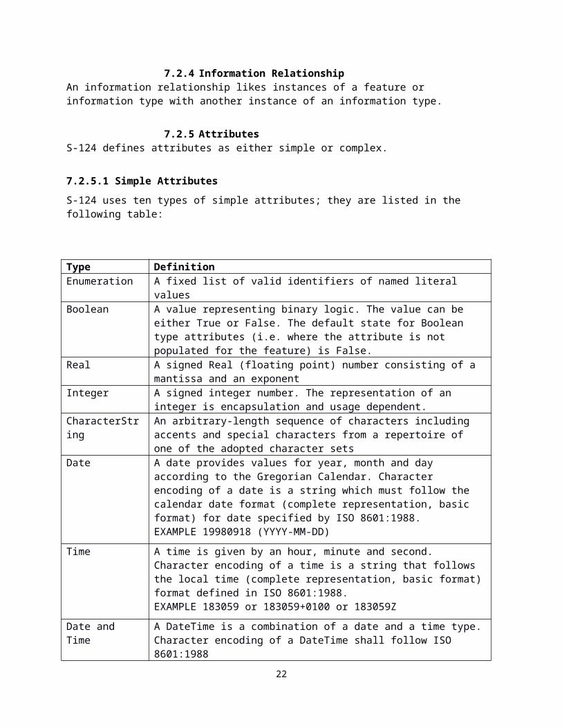
7.2.5 AttributesS-124 defines attributes as either simple or complex.
7.2.5.1 Simple AttributesS-124 uses ten types of simple attributes; they are listed in the following table:
Type DefinitionEnumeration A fixed list of valid identifiers of named literal valuesBoolean A value representing binary logic. The value can be either True or False.
The default state for Boolean type attributes (i.e. where the attribute is not populated for the feature) is False.
Real A signed Real (floating point) number consisting of a mantissa and an exponent
Integer A signed integer number. The representation of an integer is
18

encapsulation and usage dependent.CharacterString An arbitrary-length sequence of characters including accents and special
characters from a repertoire of one of the adopted character setsDate A date provides values for year, month and day according to the
Gregorian Calendar. Character encoding of a date is a string which must follow the calendar date format (complete representation, basic format) for date specified by ISO 8601:1988.EXAMPLE 19980918 (YYYY-MM-DD)
Time A time is given by an hour, minute and second. Character encoding of a time is a string that follows the local time (complete representation, basic format) format defined in ISO 8601:1988.EXAMPLE 183059 or 183059+0100 or 183059Z
Date and Time A DateTime is a combination of a date and a time type. Character encoding of a DateTime shall follow ISO 8601:1988EXAMPLE 19850412T101530
Codelist A type of flexible enumeration. A code list type is a list of literals which may be extended only in conformance with specified rules.
Truncated date One or more components of the Date type are omitted.URN A persistent, location-independent, resource identifier that follows the
syntax and semantics for URNs specified in RFC 2141.EXAMPLE urn:iho:s101:1:0:0:AnchorageArea
Table 7.1 – Simple feature attributes
.
Note: the use of URN in S-124 shall be utilizing the schema of the Maritime Resource Name (MRN) concept.
7.2.5.2 Complex Attributes
Complex attributes are aggregations of other attributes that are either simple or complex. The aggregation is defined by means of attribute bindings.
class S-124 Domain Objects
«FeatureType»S124_FeatureType
«SpatialAttribute»+ areaAffected: PointCurveOrSurface [0..*]+ geometry: NoGeometryPointCurveOrSurface [1..*]
«ComplexAttribute»+ featureName: featureName [0..*]+ featureReference: S124_featureReference [0..*]+ fixedDateRange: S124_fixedDateRange [0..*] {ordered}
«SimpleAttribute»+ restriction: restriction [0..1]+ S124_warningHazardType: S124_warningHazardType [1..*] {ordered}
«FeatureType»S124_Nav igationalWarningFeaturePart
«SimpleAttribute»+ warningInformation: S124_warningInformation [1..*]
«ComplexAttributeType»graphic
«SimpleAttribute»+ pictorialRepresentation: text+ sourceDate: Date [0..1]
«ComplexAttribute»+ pictureCaption: S124_LocalizedText [0..*]+ pictureInformation: S124_LocalizedText [0..*]
«InformationType»S124_InformationType
«S100_CodeList»S124_warningHazardType
«enum»+ aids to navigation+ dangerous wreck+ drifting hazard+ in-force bulletin+ newly discovered dangers+ offshore structures+ operating anomalies identified within ECDIS including ENC issues+ pipe or cable laying operations+ piracy+ radio navigation services+ research or scientific operations+ route alterations or suspensions+ SAR and anti pollution operations+ security-related requirements+ seismic surveys+ special operations+ tsunamis and other natural phenomena+ underwater operations+ unwieldy tow+ World Health Organization (WHO) health advisory information
tagscodelistType = open enumerationencoding = other: [something]
«ComplexAttributeType»S124_fixedDateRange
«SimpleAttribute»+ dateEnd: S100_TruncatedDate [0..1]+ dateStart: S100_TruncatedDate [0..1]+ timeOfDayEnd: Time [0..1]+ timeOfDayStart: Time [0..1]
constraints{timeOfDayStart can only be present if dateStart is also present}{timeOfDayEnd can only be present if dateEnd is also present}
«FeatureType»S124_NoticeToMarinersFeaturePart
«ComplexAttribute»+ graphic: graphic [0..*]+ information: information [1..*]
«enumeration»restriction
entry restricted = 8 entry prohibited = 7 area to be avoided = 14 stopping prohibited = 25 speed restricted = 27
Should drive portrayal of central symbol.For localization of datasets, should be encoded as a code (or key) instead of plain text.
«ComplexAttributeType»information
«SimpleAttribute»+ fileLocator: text [0..1]+ fileReference: text [0..1]+ headline: text [0..1]+ language: ISO639-3 [0..1]+ text: text [0..1]
«ComplexAttributeType»S124_affectedChartPublications
«SimpleAttribute»+ chartAffected: text [0..1]+ chartPublicationIdentifier: URN [0..1]+ internationalChartAffected: text [0..1]+ language: ISO639-3+ publicationAffected: text [0..1]
can drive portrayal of border of area NW (25, 36)
To do: Message maintenance must be elaborated. Either with message status, or with using format functions, or another way? Consider including a flow diagram to explain the process. (4)
To do: Consider if the development of a S-62 replacement can replace the current structure for capturing production agency. Likely to be a codelist maintained under theGI Registry.
To do: NW Metadata, consider S-100 standard set, which is ENC centric, should a smaller set of Metadata be proposed. Big motivating factor is that given the relatively small size of the regular NW, the current metadata might make up half the data volume.
To do: add implementation note to product specification stating that ECDIS (user system) should be able to filter in-force NWs according to a date included within periods of time of the dangers described in NWs.
«InformationType»S124_References
«ComplexAttribute»+ messageReference: S124_messageSeriesIdentifier [1..*]
«SimpleAttribute»+ referenceType: S124_referenceType
«ComplexAttributeType»featureName
«SimpleAttribute»+ displayName: boolean [0..1]+ language: ISO639-3 [0..1]+ name: text
«ComplexAttributeType»S124_ENCFeatureReference
«SimpleAttribute»+ editionNumber: text+ ENCName: text+ featureObjectIdentifier: text [1..*]+ updateNumber: text
Optional attribute, only one ENC reference per instance, one to many feature instance references within the one ENC possible.
«ComplexAttributeType»S124_LocalizedText
«SimpleAttribute»+ language: ISO639-3 [0..1]+ text: text
«invariant»{informationt:: At most 1instance for each distinctlanguage sub-attribute}
{pictureCaption,pictureInformation: At most 1instance for each distinctlanguage sub-attribute}
«InformationType»S124_NWPreamble
«ComplexAttribute»+ generalArea: S124_areaLocation [1..*] {ordered}
constraints{exactly 1 instance per dataset}
«enumeration»S124_warningType
local navigational warning = 1 coastal navigational warning = 2 sub-area navigational warning = 3 NAVAREA navigational warning = 4 NAVAREA no warning = 5 temporary notice to mariner = 13 preliminary notice to mariner = 14 miscellaneous notice to mariner = 15 permanent notice to mariner = 16 sub-area no warning = 6 coastal no warning = 7 local no warning = 8 NAVAREA in force bulletin = 9 sub-area in force bulletin = 10 coastal in force bulletin = 11 local in force bulletin = 12 temporary & preliminary notice to mariner in force bulletin = 17
«enumeration»S124_referenceType
cancellation = 1 source reference = 2 repetition = 3 update = 4 in-force = 5
«ComplexAttributeType»S124_messageSeriesIdentifier
«SimpleAttribute»+ country: ISO 3166-1 [0..1]+ nameOfSeries: text+ typeOfWarning: S124_warningType+ warningIdentifier: URN [0..1]+ warningNumber: int+ year: int
«ComplexAttribute»+ productionAgency: S62
«ComplexAttributeType»S124_areaLocation
+ S124_localityIdentifier: URN [0..1]+ S124_locationName: S124_LocalizedText
introduced to permit to link MRN identifiers to general area and locality names (6)20180209 - Yves LeFranc suggest to keep locationName as localizedText.
«InformationType»S124_Preamble
«ComplexAttribute»+ locality: S124_areaLocation [0..*] {ordered}+ messageSeriesIdentifier: S124_messageSeriesIdentifier+ S124_affectedChartPublications: S124_affectedChartPublications [0..*]+ title: S124_LocalizedText [0..*]
«SimpleAttribute»+ S124_cancellationDate: dateTime [0..1]+ S124_publicationDate: dateTime
«InformationType»S124_NMPreamble
«ComplexAttribute»+ generalArea: S124_areaLocation [0..*] {ordered}
«SimpleAttribute»+ originalInformation: Boolean+ S124_warningHazardType: S124_warningHazardType [0..*] {ordered}+ sourceAuthority: S124_LocalizedText
constraints{exactly 1 instance per dataset}
Should the 'update' value be retained? (41) Does repetition make sense in an ECDIS environment?
Added values Temporary and Preliminary (2) New name to harmonize style with other
attributes
sourceDate renamed to S124_issueDate (5) generalArea and locality have been made type S124_areaLocation (6, 7) S124_generalCategory is mandatory with option to include more values (8, 9) periodicDateRange removed (16) 20180209 - changed issueDate into publicationDate since issueDate is already used in S100
metadata, and changed type to dateTime to permit time component. 20180209 - removed fixedDateRange, and added cancellationDate as an optional attribute. 20180209 - changed generalArea cardinality from 0..1 to 0..* 20180212 - renamed generalCategory to warningHazardType and amended the cardinality to 0..*
Renamed "navOrMetArea” to “NameOfSeries" (1) MRN ID will be a 2nd ID. Is this desired? Added an
attribute called warningIdentifier to address the change. (2)
Changed the name of attribute into S-124_affectedChartPublication, and added the optional attribute publicationAffected (11)
20180212 - added optional chartPublicationIdentifier simple attribute with type URN.
timeOfDayEnd & timeOfDayStart shall always be given in UTC and both shall include the time zone reference to UTC as per ISO 8601 (14)
«metaclass»S100_GF_NamedType
+ definition: CharacterString+ isAbstract: Boolean = false+ typeName: CharacterString
«metaclass»S100_GF_ObjectType
«metaclass»S100_GF_FeatureType
«metaclass»S100_GF_InformationType
20180212 - Added fixedDateRange with cardinality of 0..* to permitted multiple intervals of information.20180214 - split into NW and NM information parts to remove the graphics option from NW.20180705 - removed S124_NavigationalWarningInformationPart as it is no longer needed given the none geometry option for the S124_NavigationalWarningFeaturePart. Same change effected on NtM parts
20180212 changed cardinality of fixedDateRange from 0..1 to 0..*
20180212 moved the graphic attribute to NM
20180213 added new featureReference attribute to permit all kinds of feature references, and not only ENC and LL.
20180214 merged the WarningPart and FeatureType
20180216 remored subject attribute as function can be done by the title attribute in warningInformation or information.
20180212 added graphic attribute
«ComplexAttributeType»S124_featureReference
«SimpleAttribute»+ featureIdentifier: URN [0..*]+ listOfLightNumber: text [0..*]
«ComplexAttribute»+ S124_ENCFeatureReference: S124_ENCFeatureReference [0..*]
«ComplexAttributeType»S124_warningInformation
«SimpleAttribute»+ headline: text [0..1]+ language: ISO639-3 [0..1]+ text: text
«invariant»{warningInformation:: Atmost 1 instance for eachdistinct language sub-attribute}
«FeatureType»S124_TextPlacement
«SimpleAttribute»+ flipBearing: real [0..1]+ scaleMinimum: integer [0..1]+ text: text+ textJustification: textJustification
«SpatialAttribute»+ geometry: Point
«enumerati...textJustification
left = 1 centred = 2 right = 3
added to permit text placements where such cartographic information can be helpful. Method replaces earlier attempts of the same function,but violated the S-100 GFM (attributessection).
+subType 0..*
inheritance
+superType 0..1
+header
+theWarningPart
0..*{ordered}
+theReferences 0..*
+theWarning
+Positions 0..*
TextAssociation
+Identifies
+theNotice
+theReferences 0..*
+subType0..*
inheritance
+superType0..1
+header
+theNoticePart
0..*{ordered}
+subType 0..*
inheritance
+superType 0..1+subType 0..*
inheritance
+superType 0..1
Figure 7.3 - featureName - a complex attribute
19
Eivind Mong, 2018-10-17,
S-100WG is drafting an MRN guidance document. When finalized, it should be referenced here.

7.3 Units of MeasureThere is no use of a specific unit of measure in the S-124 data model. However, the content of text attributes that describe the nature of navigational warnings or notices to mariners may make use of the following units of measure;
Orientation is given in decimal degrees Radio frequency is given in hertz Uncertainty is given in metres Horizontal distance is given in either metres (m) or kilometres (km) or nautical miles
(NM), as indicated by the designation Depths are given in metres Heights are given in metres
7.4 Geometric RepresentationGeometric representation is the digital description of the spatial component of an object as described in S-100 and ISO 19107. This product specification uses three types of geometries: GM_Point, GM_OrientableCurve, and GM_OrientableSurface. The feature classes defined in this specification can also use the no geometry geometric primitive. This option is reserved for cases where the geometry is too complex or the area is too large, such as whole NAVAREA warnings. In such cases a textual description of the area is expected.
Figure 7.4 - Geometric Primitives an overview of how the spatial model has been implemented in S-124. This includes the option to encode spatial uncertainty where this is required.
20

class S-124 Geometry 0.2.2
S124_Geometry
S100 V3.0 Part 7 Spatial Schema::GM_Curve
GM_CompositeS100 V3.0 Part 7 Spatial Schema::
GM_CompositeCurve
GM_PrimitiveS100 V3.0 Part 7 Spatial Schema::
GM_Point
+ position: DirectPosition
S100 V3.0 Part 7 Spatial Schema::GM_Surface
«InformationType»SpatialUncertainty
+ positionalAccuracy: real [0..1]+ qualityOfPosition: qualityOfPosition [0..1]
«Enumeration»qualityOfPosition
surveyed = 1 unsurveyed = 2 inadequately surveyed = 3 approximate = 4 position doubtful = 5 unreliable = 6 reported (not surveyed) = 7 reported (not confirmed) = 8 estimated = 9 precisely known = 10 calculated = 11
S100 V3.0 Part 7 Spatial Schema::
GM_Object
IO_IdentifiedObjectBaseRS_ReferenceSystem
S100_IO_IdentifiedObject
«type»Coordinate Reference Systems::
SC_CRS
+ scope: CharacterString [1..*]
GM_PrimitiveS100 V3.0 Part 7 Spatial Schema::
GM_OrientableSurface
+ orientation: Sign
GM_PrimitiveS100 V3.0 Part 7 Spatial Schema::
GM_OrientableCurve
+ orientation: Sign
«abstraction»
0..* 0..1
0..1
+component 1..*
0..*
«abstraction»
«abstraction»
0..10..1
«abstraction»
Figure 7.4 - Geometric Primitives
8 Coordinate Reference System (CRS)8.1 IntroductionThe location of an object in the S-100 standard is defined by means of coordinates which relate a feature to a position. The coordinate reference system used for this product specification is World Geodetic System 1984 (WGS 84) which is defined by the European Petroleum Survey Group (EPSG) code 4326, (or similar - North American Datum 1983 / Canadian Spatial Reference System).
Spatial data are expressed as latitude (φ) and longitude (λ) geographic coordinates. Latitude values are stored as a negative number to represent a position south of the Equator. Longitude values are stored as a negative number to represent a position west of the Prime Meridian.
21
Coordinates are expressed as real value, degree / degree decimal format. Datasets conforming to this product specification are not projected.
Horizontal coordinate reference system: WGS 84
Projection: None
Vertical coordinate reference system: Although all coordinates in a data set must refer to the same horizontal CRS different Vertical Datums can be used for the depth component of a coordinate tuple. Therefore the vertical CRS can be repeated. For each Vertical CRS a unique identifier is defined. Those identifiers will be used to indicate which Vertical CRS is used. Units must be in metres. (From S-101 Draft).
Temporal reference system: Gregorian calendar
Coordinate reference system registry: EPSG Geodetic Parameter Registry
Date type (according to ISO 19115): 002 - publication
8.2 Horizontal reference systemPositional data is expressed in latitude and longitude geographic coordinates to World Geodetic System 84 (WGS 84).
8.3 ProjectionNavigational Warning data products are un-projected.
8.4 Vertical coordinate reference systemAlthough all coordinates in a dataset must refer to the same horizontal CRS different Vertical Datums can be used for the depth or heights in Navigational Warning datasets. There is no use of a specific unit of measure in the S-124 data model. However, the content of text attributes that describe the nature of navigational warnings or notices to mariners may include information about heights or depths. When this is the case, the vertical datum used in the measurement shall be made clear from the text.
8.5 Temporal reference systemTime is measured by reference to Calendar dates and Clock time in accordance with ISO 19108:2002 Temporal Schema clause 5.4.4. All instances of time are expressed in UTC.
9 Data Quality9.1 IntroductionS-124 products must be tested with the S-124 specific checks prior to release by the data producer. The data producer must review the check results and address any issues to ensure sufficient quality of the data products. The checks are a mix of data format validation checks,
22

conformance to standard checks and logical consistency checks. The checks are listed in Annex E.
10 Data Capture and ClassificationS-124 products are the result of the official production agency process. S-124 products must be based on data sources deemed reliable by the production agency. The Data Classification and Encoding Guide (DCEG) describes how data describing a Navigational Warning should be captured using the types defined in the S-124 Feature Catalogue, and is found in Annex A. General principles for Navigational Warnings according to WWNWS, such as how to administer a NAVAREA, what constitute a sub area warning and coastal warning are found in S-53 - Joint IHO/IMO/WMO Manual on Maritime Safety Information (MSI). Local warnings are outside of scope of S-53, and will be defined in national or local documentation.
10.1 Data Encoding and Product Delivery10.1.1 Data EncodingThe principal encoding is the Open Geospatial Consortium (OGC), Geography Markup Language (GML) format as profiled by the S-100 GML schema in Part 10b of S-100. GML is an XML grammar designed to express geographical features. It serves as a modelling language for geographic systems as well as an open interchange format for geographic transactions. The XML Schema for the GML application schema is provided at (http://www.iho.int/schemas/…). Feature instance shall validate against the schema and conform to all other requirements specified in this data product specification including all constraints not captured in the XML Schema document.
10.1.2 Types of DatasetsA dataset is a grouping of features, attributes, geometry and metadata which comprises a specific coverage. There are five types of S-124 datasets, and each dataset contain only one Navigational Warning or In-force Bulletin.Dataset type ExplanationsNew dataset Dataset with a new warning or notice. The
dataset is valid till a cancellation dataset is issued.
New dataset self-cancelling Dataset with a new warning or notice that include a cancellation date.
New dataset with cancellation Dataset used to cancel previous warning or notice. May include updated information related to the warning or notice that is being cancelled.
New dataset with cancellation self-cancelling Dataset used to cancel previous warning or notice. May include updated information related to the warning or notice that is being cancelled. Includes a cancellation date.
In-force bulletin Dataset that reference all in-force navigational warnings, and always cancel the previous in-force bulletin.
Table 10.2 - Dataset types
23
Eivind Mong, 2018-10-17,
To be created..
Eivind Mong, 2018-10-17,
tests must be created. S-100WG is considering a speciic set of minimum tests that may have to be adopted. Additionally, inspiration can be had from other GML product specifications, such as S-122, S-123, S-201.

10.1.3 Content of Datasets New dataset - Dataset with warning information that is valid till another dataset
with cancellation information is issued. Dataset will contain one preamble, at least one feature instance, and may contain one or more reference information type instances.
New dataset self-cancelling - Dataset with warning information that is valid till the cancellation date in the preamble. Dataset will contain one preamble, at least one feature instance, and may contain one or more reference information type instances.
New dataset with cancellation – Dataset that can contain updated information to a previously issued dataset, and will contain cancellation information for at least one previous dataset. Dataset will contain one preamble, one or more reference information type instances and may contain one or more feature instances.
New dataset with cancellation self-cancelling - Dataset that can contain updated information to a previously issued dataset, and will contain cancellation information for at least one previous dataset. Dataset is valid till the cancellation date in the preamble. Dataset will contain one preamble, at least one reference information type instance and may contain one or more feature instances.
In-force bulletin – Dataset that references all navigational warnings that are valid at the time of issue. In-force bulletin datasets always cancel the previous in force-bulletin. Dataset will contain one preamble, and may contain one or more reference information type instances and must not contain any feature instance.
10.1.4 In-force bulletin datasetAll datasets should be considered in-force and valid till a new dataset with cancellation information is issued or where cancellation date is present in a dataset, that date is passed. The in-force bulletin should not be used by a producer to cancel valid datasets, that function is reserved for a new dataset with cancellation information for previously issued datasets.
10.1.5 No message on handWhen there are no active messages in a series, the regularly issued in-force bulletin dataset must be encoded with an NWPreamble associated with only one instance of References. The References instance shall have referenceCategory set to in-force, and the noMessageOnHand set to true.
10.2 Encoding of Latitude and Longitude Values of latitude and longitude must be accurate to 7 decimal places. Coordinates must be encoded as decimals in the format described below. The encoding is indicated by multiplication factor fields defined in the dataset identification record.
10.2.1 Encoding of coordinates as decimalsValues should be coded as decimal numbers with 7 or fewer digits after the decimal. The normative encoding is in degrees, with an accuracy of 10-7 degrees, i.e., up to 7 digits after the decimal point.
The decimal point must be indicated by the “.” character.
Trailing zeroes after the decimal point (and the decimal point itself if appropriate) may be omitted at producer discretion, but the accuracy must still be as indicated (e.g., 10-7 degrees for coordinates of default accuracy).
24
Eivind Mong, 2018-10-17,
May need to revisit this statement for push services. To do -> create a timeline of what happens to NW received by a ship that enters and leaves the zone and then re-enter a few weeks later. This can be a first test to see how the defined messages function in a push service.
Eivind Mong, 2018-10-17,
To account for ‘no message at hand’

Latitude and longitude multiplication factors held in the Dataset Structure Information field under [coordMultFactorX] and [coordMultFactorY] must be set to a value corresponding to the encoding, i.e., {1} for coordinates encoded in decimal degrees.
EXAMPLE 1 A longitude = 42.0000 is converted into X = longitude * coordMultFactorX = 42.0000 * 1 = 42.0000000.
10.3 Numeric Attribute EncodingFloating point and integer attribute values must not contain leading zeros. Floating point attribute values must not contain non-significant trailing zeros.
10.4 Text Attribute Values Character strings must be encoded using the character set defined in ISO 10646-1, in Unicode Transformation Format-8 (UTF-8).
10.5 Mandatory Attribute Values There are four reasons why attribute values may be considered mandatory:
They determine whether a feature is in the display base,
Certain features make no logical sense without specific attributes,
Some attributes are necessary to determine which symbol is to be displayed,
Some attributes are required for safety of navigation.
All mandatory attributes are identified in the Feature Catalogue and summarised in Annex A – Data Classification and Encoding Guide.
10.6 Unknown Attribute Values Mandatory attributes in an S-124 dataset are not permitted to contain a nil value. All mandatory attributes must contain meaningful data.
10.7 Structure of dataset files10.7.1 Sequence of objects
The order of data objects in each dataset file is described below:
Dataset Identification InformationDataset structure informationSpatial records for by-reference geometries
PointMulti pointCurve Composite CurveSurface
Information objectsFeature objects (Geometry may be encoded inline or by reference.)
Meta featuresGeo features
25

10.8 Object identifiersThe “name” of feature records must provide a unique world-wide identifier of feature records following the MRN schema. [To be updated when MRN guidance document has been finalized]
The MRN schema is structured as follows; urn:mrn:OID:OSS
OID is an identifier like IHO, IALA, IMO etc
OSS are ids provided by the organization identified by the OID, which can create them, handle them, delete them, store them in registries as they see fit. An organization that issues an MRN ID must make sure that THEIR OSS is not used twice for different purposes. Together with the individual OID the resulting MRN are globally unique.
Features, information types, and geometries (inline or referenced) are all required by the schema to have a gml:id attribute with a value that is unique within the dataset. The gml:id values must be used as the reference for the object from another object in the same dataset or another dataset.
[To do: add something about linking S-124 Navigational Warnings with same Navigational Warning received via NAVTEX, SafetyNet or other distribution channel and giving preference to S-124]
10.9 Data coverageA common feature of S-100 based datasets is a data coverage meta feature class. Navigational Warnings, are however more resemble messages and contain only the essential information to communicate urgent safety information. Therefore a distinct meta feature class to mark the data coverage is not included. The discovery metadata associated with each S-124 dataset fulfills this function.
10.10 Data overlapS-124 datasets may overlap other S-124 datasets.
10.11 Data qualityNavigational Warning datasets are always compiled from best available sources. These sources often do not contain sufficient details to make an assessment regarding quantitative data quality. This fact, in combination with the general urgency of distributing Navigational Warning information are the primary reasons why no quantitative quality attributes have been added to this version of S-124.
All S-124 datasets must pass validation checks as detailed in Annex E, without any critical errors.
.
10.12 Use of datasetsS-124 datasets are intended to be used as overlay information with ENC. This means that S-124 datasets must be created with content sufficient to communicate the intended information to
26
Eivind Mong, 2018-10-17,
To be done.
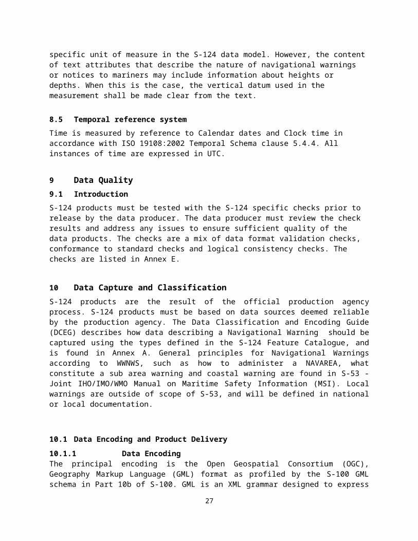
a user when the user views the datasets over ENCs. This includes sufficient accuracy of location information, as well as sufficient levels of details on the navigational safety information contained in the S-124 dataset.
10.13 Scale in S-124 datasetsNavigational Warning data must be compiled in the best applicable scale. The use of the data itself is scale independent. That means that the data can be used at any scale
10.14 Filtering Navigational Warning informationUser systems may provide filtering mechanisms for the Navigational Warning information. Filtering functions could include options like filtering on route + buffer, navigational warning topic, date range of the hazard, or valid time of the navigational warning.
11 Data Delivery11.1 Data Product Delivery InformationThis data product specification defines GML as the primary format in which S-124 data products are delivered. The delivery format is described by the following items (from ISO 19131:2005): format name, version, specification, language, character set.
Name ISO 19131 Elements Value
Format
name
DPS_DeliveryInformation.deliveryFormat >
DPS_DeliveryFormat.formatNameGML*
VersionDPS_DeliveryInformation.deliveryFormat >
DPS_DeliveryFormat.version3.2.1
Specification
description
DPS_DeliveryInformation.deliveryFormat >
DPS_DeliveryFormat.specificationGML*
LanguageDPS_DeliveryInformation.deliveryFormat >
DPS_DeliveryFormat.language
English
English
Character
set
DPS_DeliveryInformation.deliveryFormat >
DPS_DeliveryFormat.characterSet > MD_CharacterSetCode004 – utf8
Table 11.3 - Data Product Delivery
11.2 Dataset loading
11.2.1 Use of S-124 in ECDISIn ECDIS all valid S-124 datasets must always be loaded. Validity is indicated by the cancellationDate attribute in the NWPreamble class, and any point in time prior to this time value the dataset is valid. Validity is terminated if a cancellation dataset is issued before the
27
cancellationDate of a dataset. Validity is also indicated by the NW being present in the in-force bulletin.
11.2.2 Section for producer Technical serviceTo be further developedA maritime safety broadcast1 client system must be registered into the producer technical service. It is recommended that other client systems be also registered.The producer technical service must deliver on request from the client systems:
- the list of the series of the producer- the complete set of valid NW datasets in a selected series- the valid in-force bulletin dataset of a selected series. The valid in-force bulletin dataset
must be synchronized with valid NW datasets issued.- The NW datasets of a list of Ids of selected NW datasets of series.
The producer technical service should deliver on request:- information about production process of a series for quality management purposes.- quality meta-data of a series
The producer technical service must notify a registered client system participating to maritime safety when a vital or an important NW dataset is issued in series subscribed by the client.This notification includes the NW dataset.The producer technical service may notify a registered client systems when a new in-force bulletin dataset is issued in a series subscribed by the client. This notification includes the new in-force bulletin dataset.
11.2.3 Section for push broadcast systems using the producer TS (radio stations …)
To be further developed
For using the technical service of a producer, a maritime safety broadcast client systems must be registered into the producer technical service and must subscribe to the series that it supports.A maritime safety broadcast systems using the producer technical service must be able to send the requests described above to the producer technical service and to proceed with the replies. It must be able to receive the notifications described above from producer technical service and to proceed with them.Maritime safety broadcast systems must broadcast simultaneously all valid NW datasets and the valid in-force bulletin dataset of a supported series at each scheduled broadcast.A vital or an important NW dataset must be broadcast immediately.
11.3 In-force bulletin
If the in-force bulletin contain NW that are not present in the system, an indication should be given.
11.4 Dataset cancellation
S-124 Datasets may be cancelled in three ways;
1 Broadcast in push mode
28
Yves Le Franc, DTRI/CTRI, 2018-10-17,
24/07: I would be happy to know more about ideas around the pull scenario. I am afraid that it would be more demanding (less robust, more expensive) in terms of datalink-connexion, data services-clients management. Perhaps, pull scenario can also use in force-bulletins (a NW not in the in force-bulletin is no more valid) rather than the search of an old (and stored ?) cancellation dataset by the server of the producer. Push and pull scenarios have to be discussed within the group and the WWNWS-SC.
Yves Le Franc, DTRI/CTRI, 10/17/18,
24/07: tentative for push scenario
Yves Le Franc, DTRI/CTRI, 2018-10-17,
24/07 Push broadcast

by populating the cancellationDate attribute; or sending a cancellation message which contain only on instance of a References
information type with the referenceType attribute set to 1 (cancellation), and the messageReference with the identifier of the datasets to be cancelled.
or sending a new message with updated information and a References information type with the referenceType attribute set to 1 (cancellation), and the messageReference with the identifier of the previous datasets to be cancelled.
[consider adding the in-force bulletin as another method to cancel datasets]
11.5 Updating datasets
In order to update the information provided in a S-124 datasets a new dataset which cancel the previous information and contain updated information must be issued.
11.6 Exchange SetDatasets which conforms to this product specification must be delivered by means of an exchange set. [To be revisited to consider if suitable for both push and pull distribution, and update to comply with S-100 Ed 4.0.0 when released.]
An exchange set will consist of one or more S-124 datasets. An exchange set may also include one or more support files, such as updated feature and portrayal catalogues. Each exchange set will include a single (XML) catalogue file, S-124 exchange set catalogues conform to S-100 3.0.0 Figure 4a-D-2 without modification, containing discovery metadata for each S-124 dataset as well as support files. S-124 Exchange set structure conforms to S-100 3.0.0 Figure 4a-D-3 without modification.
Figure 11.5 - Exchange set structure
29

11.7 Dataset sizeS-124 datasets shall not exceed 50KB11.8 Support Files
For Navigational Warnings, support files are limited to new versions of either of the feature or portrayal catalogues.
11.9 Dataset Naming ConventionAll dataset files will have unique world-wide file identifiers. The file identifier of the dataset should not be used to describe the physical content of the file. The dataset file metadata that accompanies the file will inform the user of the name and purpose of the file (new, new with cancellation, new self-cancelling, new with cancellation and self-cancelling, and in-force bulletin). In this encoding the dataset files are named according to the specifications given below:
124YYYYXXXXXXXX.GML
The main part forms an identifier where: the first three characters identify the dataset as an S-124 Navigational Warning; the fourth to seventh characters identify the issuing agency of the NW [according to S-
62?]; the eighth up to the fifteenth character can be used in any way by the producer to
provide a unique file name for the dataset. The following characters are allowed in the dataset name, A to Z, 0 to 9 and the special character _ (underscore). It is not mandatory to use all characters in this group.
11.10 Catalogue File Naming ConventionThe exchange catalogue acts as the table of contents for the exchange set. The catalogue file of the exchange set must be named CATALOG.XML. No other file in the exchange set may be named CATALOG.XML. The content of the exchange catalogue file is described in Section 14.
12 Data Maintenance12.1 IntroductionS-124 datasets in a series are issued as per any situation arise requiring safety critical information be made known to mariners. Datasets of the series are maintained as needed and must be done according to paragraph 11.2. When related of the same event, series dataset updates will be made by new datasets which cancel any preceding datasets.
Data Producers must use applicable sources to maintain and update data and may provide a brief description of the sources that were used to produce the dataset if this information is relevant. It is up to the Data Producer to determine what an appropriate source when creating Navigational Warning datasets is. S-53 chapter 3 ‘NAVAREA/SUB-AREA/NATIONAL COORDINATORS' RESOURCES AND RESPONSIBILITIES’ gives further information on how to manage information streams when creating S-124 Navigational Warnings within the WWNWS framework. Local warnings may be subject to national or regional guidelines.
30
Eivind Mong, 2018-10-17,
Just a guess..

The specific production process is up to each Data Producer. The Data Producer should sufficiently document their individual production process for quality management purposes.12.2 Production process for base and update datasetsData Producers should follow their established production processes for maintaining and updating datasets. Data is produced against the DCEG and checked against the appropriate set of validation rules in Appendix E.12.3 Information updatesThe purpose of issue of the dataset is indicated in the “purpose” field of the dataset discovery metadata. In order to cancel a dataset, the process described in 11.4 is followed. To update information a new dataset with updated information is issued including cancellation information for previously issued datasets on the same topic.
Where a dataset is cancelled and its name is reused at a later date, the issue date must be newer than the issue date of the cancelled dataset.
When the dataset is cancelled it must not be displayed on the navigation system when it is used in route following mode.
12.4 Support file updatesThe purpose of issue is indicated in the “purpose” field of the support file discovery metadata. Support files carrying the “deletion” flag in metadata must be removed from the system. When a feature or information type pointing to a text, picture or application file is deleted or updated so that it no longer references the file, the system software must check to see whether any other feature or information type references the same file, before that file is deleted.
Updates or deletions of a support file may require concurrent updates to feature or information type instance attributes that depend on the file, e.g., pictorialRepresentation, fileReference and fileLocator attributes.m
12.5 Feature and portrayal cataloguesFor each new edition (n.0.0, see 4.3.5) of the S-124 Product Specification a new feature and portrayal catalogue will be released. A revision (n.n.0) may also include a new feature and/or portrayal catalogue. The system must be able to manage datasets and their catalogues that are created on different versions of the S-124 product specification.
31
Eivind Mong, 2018-10-17,
To be created

13 PortrayalNavigational Warnings portrayal is provided by a portrayal catalogue that includes a symbol set and symbol instructions for the various feature and attribute combinations. Annex F contains the portrayl catalogue using the XSLT concept from S-100.
Note: First version is created for test in the SMART Navigation Project and is only added for stimulating discussion and further development in S-124CG.
32

14 Metadata14.1 IntroductionThe S-124 metadata description is based on the S-100 metadata document section, which is a profile of the ISO 19115 standard. These documents provide a structure for describing digital geographic data and define metadata elements, a common set of metadata terminology, definitions and extension procedures.
Two metadata packages are described in this product specification: dataset metadata and exchange set metadata.
33

class S-124 Metadata
Part of S-124 exchange set
Related to MD_SecurityConstraints
Related to MD_Usage (mandatory)
Related to S100_DataCoverage
related to CI_ResponsibleParty (mandatory)
«InformationType»S-124 Abstract Types::S124_InformationType
S124_DatasetDiscoveryMetadata
+ classification: MD_SecurityConstraints [0..1]+ comment: CharacterString [0..1]+ copyright: MD_RestrictionCode [0..1]+ dataCoverage: S100_DataCoverage [1..*]+ dataProtection: Boolean [0..1]+ dataType: S100_DataFormat+ dataTypeVersion: CharacterString+ description: CharacterString+ digitalSignature: CharacterString [0..1]+ editionNumber: CharacterString+ fileName: CharacterString+ filePath: CharacterString+ horizontalDatumReference: CharacterString = EPSG+ horizontalDatumValue: Integer = 4326+ issueDate: Date+ layerID: CharacterString [0..*]+ maximumDisplayScale: Integer [0..1]+ minimumDisplayScale: Integer [0..1]+ optimumDisplayScale: Integer [0..1]+ otherDataTypeDescription: CharacterString [0..1]+ producingAgency: CI_ResponsibleParty+ productSpecification: S100_ProductSpecification+ protectionScheme: CharacterString [0..1]+ purpose: CharacterString+ soundingDatum: S100_VerticalAndSoundingDatum+ specificUsage: MD_Usage+ updateApplicationDate: Date [0..1]+ updateNumber: CharacterString+ verticalDatum: S100_VerticalAndSoundingDatum
S-124 Dataset
«datatype»Citation and responsible party information::
CI_ResponsibleParty
+ contactInfo: CI_Contact [0..1]+ individualName: CharacterString [0..1]+ organisationName: CharacterString [0..1]+ positionName: CharacterString [0..1]+ role: CI_RoleCode
«CodeList»Citation and responsible
party information::CI_RoleCode
+ author+ custodian+ distributor+ originator+ owner+ pointOfContact+ principalInvestigator+ processor+ publisher+ resourceProvider+ user
«datatype»Citation and responsible party information::
CI_Contact
+ address: CI_Address [0..1]+ contactInstructions: CharacterString [0..1]+ hoursOfService: CharacterString [0..1]+ onlineResource: CI_OnlineResource [0..1]+ phone: CI_Telephone [0..1]
«datatype»Citation and responsible party information::
CI_Address
+ administrativeArea: CharacterString [0..1]+ city: CharacterString [0..1]+ country: CharacterString [0..1]+ deliveryPoint: CharacterString [0..*]+ electronicMailAddress: CharacterString [0..*]+ postalCode: CharacterString [0..1]
«datatype»Citation and responsible party
information::CI_Telephone
+ facsimile: CharacterString [0..*]+ voice: CharacterString [0..*]
«datatype»Citation and responsible party information::
CI_OnlineResource
+ applicationProfile: CharacterString [0..1]+ description: CharacterString [0..1]+ function: CI_OnLineFunctionCode [0..1]+ linkage: URL+ name: CharacterString [0..1]+ protocol: CharacterString [0..1]
«CodeList»Constraint information::
MD_RestrictionCode
+ copyright+ intellectualPropertyRights+ license+ otherRestrictions+ patent+ patentPending+ restricted+ trademark
Identification information::MD_Usage
+ specificUsage: CharacterString+ usageDateTime[0..1]: DateTime+ userContactInfo[1..*]: CI_ResponsibleParty+ userDeterminedLimitations[0..1]: CharacterString
S100 V3.0 Part 4a Metadata::S100_DataCoverage
+ boundingBox: EX_GeographicBoundingBox+ boundingPolygon: EX_BoundingPolygon [1..*]+ ID: Integer+ maximumDisplayScale: Integer [0..1]+ minimumDisplayScale: Integer [0..1]+ optimumDisplayScale: Integer [0..1]
EX_GeographicExtentExtent information::
EX_GeographicBoundingBox
+ eastBoundLongitude: Angle+ northBoundLatitude: Angle+ southBoundLatitude: Angle+ westBoundLongitude: Angle
EX_GeographicExtentExtent information::EX_BoundingPolygon
+ polygon: GM_Object [1..*]
«enumeration»S100 V3.0 Part 4a
Metadata::S100_DataFormat
ISO/IEC 8211 ASCII ISO/IEC 8211 BINARY GML HDF5 other
S100 V3.0 Part 4a Metadata::S100_ProductSpecification
+ date: Date+ name: CharacterString+ version: CharacterString
«enumeration»S100 V3.0 Part 4a Metadata::
S100_VerticalAndSoundingDatum
meanLowWaterSprings meanSeaLevel meanLowerLowWaterSprings lowestLowWater meanLowWater lowestLowWaterSprings approximateMeanLowWaterSprings indianSpringLowWater lowWaterSprings approximateLowestAstronomicalTide nearlyLowestLowWater meanLowerLowWater lowWater approximateMeanLowWater approximateMeanLowerLowWater meanHighWater meanHighWaterSprings highWater approximateMeanSeaLevel highWaterSprings meanHigherHighWater equinoctialSpringLowWater lowestAstronomicalTide localDatum internationalGreatLakesDatum1985 meanWaterLevel lowerLowWaterLargeTide higherHighWaterLargeTide nearlyHighestHighWater highestAstronomicalTide
S100 V3.0 Part 4a Metadata::S100_DatasetDiscoveryMetadata
+ classification: MD_SecurityConstraints [0..1]+ comment: CharacterString [0..1]+ copyright: MD_RestrictionCode [0..1]+ dataCoverage: S100_DataCoverage [1..*]+ dataProtection: Boolean [0..1]+ dataType: S100_DataFormat+ dataTypeVersion: CharacterString+ description: CharacterString+ digitalSignature: CharacterString [0..1]+ editionNumber: CharacterString+ fileName: CharacterString+ filePath: CharacterString+ horizontalDatumReference: CharacterString+ horizontalDatumValue: Integer+ issueDate: Date+ layerID: CharacterString [0..*]+ maximumDisplayScale: Integer [0..1]+ minimumDisplayScale: Integer [0..1]+ optimumDisplayScale: Integer [0..1]+ otherDataTypeDescription: CharacterString [0..1]+ producingAgency: CI_ResponsibleParty+ productSpecification: S100_ProductSpecification+ protectionScheme: CharacterString [0..1]+ purpose: CharacterString+ soundingDatum: S100_VerticalAndSoundingDatum+ specificUsage: MD_Usage+ updateApplicationDate: Date [0..1]+ updateNumber: CharacterString+ verticalDatum: S100_VerticalAndSoundingDatum
S-124 version of the metadata. Is it a verbatim copy of S-100, or do we need to modify it? For example, can most of the optional attributes be eliminated?Consider writing a paper to S-100WG asking for a solution.
MD_ConstraintsConstraint information::MD_SecurityConstraints
+ classification: MD_ClassificationCode+ classificationSystem: CharacterString [0..1]+ handlingDescription: CharacterString [0..1]+ userNote: CharacterString [0..1]
«CodeList»Constraint information::MD_ClassificationCode
{root,leaf}
+ confidential+ restricted+ secret+ topSecret+ unclassified
Can likely be set once for a production system and then all NW issued will contain the same information.
Can likely be set once for a production system and then all NW issued will contain the same information.
Mandatory, and may be automated by production system using NW geometry.
optional, ignore for all NW, since the information is always public?
class V3.0.0 Fig 4a-D3 S100 ExchangeSet
S100_CatalogueMetadata
S100_ExchangeCatalogue
S100_SupportFileDiscoveryMetadataS100_DatasetDiscoveryMetadata
S100_DatasetS100_ExchangeSetS100_SupportFile
Discovery metadata for a support file for a dataset should be located or referenced as shown in Figure 4a-D.2, in the dataset discovery metadata.
Discovery metadata for a support file for the exchange set should be located or referenced in the exchange catalogue (as shown in this figure).
+aggregateCatalogue
0..* +datasetCatalogue0..*
+datasetDiscoveryMetadata 0..*+supportFileDiscoveryMetadata0..*
1
+aggregateFile
0..*
+aggregateCatalogue
+superSet 0..*
MultiAggregation +subSet 0..*
+composedOf
1..*+partOf
0..*
11
+supportFile
0..*
Hor datum reference has been made fixed to WGS84 (26, 35)
1..*
«trace»
Figure 14.6 – Overview of [draft] Metadata
34

Note 1: Types with CI_, EX_, and MD_ prefixes are from packages defined in ISO 19115 and adapted by S-100. Types with S100_ prefix are from packages defined in S-100. Note 2: When a dataset is terminated, the purpose metadata field is set to 3 (terminated), and the editionNumber metadata field is set to 0. All other metadata fields must be blank.
14.2 Dataset MetadataDataset metadata is intended to describe information about a dataset. It facilitates the management and exploitation of data and is an important requirement for understanding the characteristics of a dataset. Whereas dataset metadata is usually fairly comprehensive, there is also a requirement for a constrained subset of metadata elements that are usually required for discovery purposes. Discovery metadata are often used for building web catalogues, and can help users determine whether a product or service is fit for purpose and where they can be obtained.[Must be updated with S-100 Ed. 4.0.0]
Name Cardinality Value Type RemarksS100_DataSetDiscoveryMetadatafileName 1 CharacterString Dataset file name (see11.9)filePath 1 CharacterString Full path from the exchange set
root directorydescription 1 CharacterStringdataProtection 0..1 {1} or
{2}CharacterString 1. Encrypted
2. UnencryptedprotectionScheme 0..1 CharacterString For example S-63digitalSignature 0..1 CharacterStringdigitalSignatureReference
0..1 CharacterString
digitalSignatureValue
0..1 CharacterString
copyright 0..1 MD_LegalConstraints ->MD_RestrictionCode<copyright> (ISO 19115)
classification 0..1 ClassMD_SecurityConstraints>MD_ClassificationCode (codelist)
1. unclassified2. restricted3. confidential4. secret5. top secret
purpose 1 {1}, {2} CharacterString 1. New dataset2. New dataset self-cancelling3. New dataset with cancellation4. New dataset with cancellation self-cancelling5. In-force bulletin
35

specificUsage 1 MD_USAGE>specificUsage(character string)MD_USAGE>userContactInfo(CI_ResponsibleParty)
brief description of the resource and/or resource series usage
editionNumber 1 {1} Integer When a dataset is initially created, the edition number “1” is assigned to it. The edition number is increased by one with each new edition.
issueDate 1 Date Date on which the dataset was generated.
productSpecification
1 S-124 version N.n
CharacterString This must be encoded as S124.N.n
producingAgency 1 CI_ResponsibleParty
Party responsible for generating the dataset.
horizontalDatum 1 WGS84 CharacterString The datum for latitude/longitude. EPSG:4326
verticalDatum 1 WGS84 CharacterString EPSG:4326dataType 1 GML CharacterStringdataTypeVersion 1 3.2.1 CharacterStringdataCoverage 1..* S100_DataCover
agecomment 0..1 CharacterString Any additional InformationlayerID 1..* S-57, S-
101CharacterString Dataset must be used with ENC
in an ECDISTable 14.1 – Dataset Metadata
14.3 Support file MetadataSupport file metadata is intended to describe information about a data resource. It facilitates the management and exploitation of data and is an important requirement for understanding the characteristics of a data resource. [In S-124 it will be for updating the feature and portrayal catalogues]
Name Cardinality Value Type RemarksS100_SupportFiletDiscoveryMetadatafileName 1 CharacterStringfileLocation 1 CharacterString Path relative to the root
directory of the exchange set. The location of the file after the exchange set is unpacked into
36
Eivind Mong, 2018-10-17,
Probably not needed, consider deleting. Will be optional in S-100 Ed. 4.0.0

directory <EXCH_ROOT> will be<EXCH_ROOT>/<filePath>/<filename>
purpose 1 S100_SupportFilePurpose
new, replacement, or deletion
editionNumber 1 CharacterString When a data set is initially created, the edition number 1 is assigned to it. Theedition number is increased by 1 at each new edition. Edition number remains the same for a re-issue
issueDate 1 DateproductSpecification 1 S100_ProductSpec
ificationdataType 1 S100_SupportFileF
ormatotherDataTypeDescription
0..1 CharacterString
dataTypeVersion 1 CharacterStringcomment 0..1 CharacterStringdigitalSignatureReference
0..1 CharacterString Reference to the appropriate digital signature algorithm
digitalSignatureValue 0..1 CharacterStringTable 14.2 Support File Metadata
37
Eivind Mong, 10/17/18,
Needed for new versions of the feature catalogue and portrayal catalogue.

14.4 Exchange Set MetadataFrequently datasets are packaged and distributed as composite exchange sets by third party vendors. An exchange set could contain many different types of datasets, sourced from different data producers. For example an exchange set may contain numerous dataset files, ancillary data files, discovery metadata files and others. Exchange set metadata contains metadata about the contents of the exchange set and metadata about the data distributor.
14.4.1 Catalogue File Metadata.All S-124 Catalogue metadata files must contain at least the following metadata elements.
Name Cardinality Value Type RemarksS100_ExchangeCatalogueidentifier 1 S100_CatalogueId
entifiercontact 1 S100_CataloguePo
intOfContact
productSpecification
0..1 S100_ProductSpecification
Conditional on all the datasets using thesame product specification
metadataLanguage 1..2 English, French
CharacterString All data sets conforming to this PS must use English language. The catalogue file must be in English with the optional addition of French.
exchangeCatalogueName
1 CATALOG.XML
CharacterString Catalogue filename
exchangeCatalogueDescription
1 CharacterString
exchangeCatalogueComment
0..1 CharacterString Any additional Information
compressionFlag 0..1 Boolean Yes or NoproductSpecification algorithmMethod
0..1 CharacterString For example. RAR or ZIP
sourceMedia 0..1 CharacterString
replacedData 0..1 Boolean
dataReplacement 0..1 CharacterString
Table 14.3 Catalogue File Metadata
38

Appendix A. Data Capture and Encoding Guide[To be done]
39

Appendix C. Feature Catalogue
Name: Navigational Warnings Feature CatalogueScope: Version Number: 1.0Version Date: 2017-05-04Producer:
International Hydrographic Bureau, 4 quai Antoine 1er,B.P. 445MC 98011 MONACO CEDEXTelephone: +377 93 10 81 00Telefax: + 377 93 10 81 40
Language: English
(See Annex with review print of Feature Catalogue.)
40

Appendix D-1. GML Data Format Overview
This data format conforms to the profile described in S-100 Part 10b, which is based on GML.
41

Appendix E. Validation Checks
42
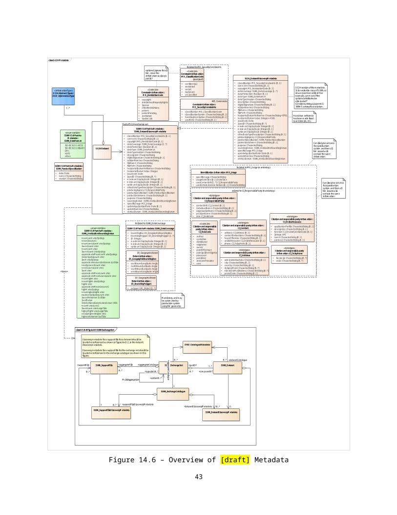
Appendix F. Portrayal CatalogueName: Navigational Warnings Portrayal CatalogueScope: Navigational WarningsVersion Number: 0.1Version Date: 2018-06-12Producer:
International Hydrographic Bureau, 4 quai Antoine 1er,B.P. 445MC 98011 MONACO CEDEXTelephone: +377 93 10 81 00Telefax: + 377 93 10 81 40
Language: English
43


![arXiv:1507.07356v2 [math.AP] 14 Sep 2015 · in literature, such as inversion of Riesz potentials, we are able to cover all Lp spaces, with no restrictions on p∈ [1,∞), as well](https://static.fdocument.org/doc/165x107/5cc0c4d288c99335358c6c7e/arxiv150707356v2-mathap-14-sep-2015-in-literature-such-as-inversion-of.jpg)