ORIENTAL - AUTOMATIC GEO-REFERENCING AND … · oriental - automatic geo-referencing and...
6
ORIENTAL - AUTOMATIC GEO-REFERENCING AND ORTHO-RECTIFICATION OF ARCHAEOLOGICAL AERIAL PHOTOGRAPHS W. Karel φ,ψ* , M. Doneus φ,χ , G. Verhoeven χ,φ , C. Briese χ,ψ , C. Ressl ψ , N. Pfeifer ψ φ Vienna Institute for Archaeological Science, University of Vienna Franz-Klein-Gasse 1, 1190 Vienna, Austria χ LBI for Archaeological Prospection & Virtual Archaeology Hohe Warte 38, 1190 Vienna, Austria ψ Department of Geodesy and Geoinformation, Vienna University of Technology Gusshausstrasse 27-29, 1040 Vienna, Austria KEY WORDS: aerial photograph, orientation, georeference, archaeology, automation, software ABSTRACT: This paper presents the newly developed software OrientAL, which aims at providing a fully automated processing chain from aerial photographs to orthophoto maps. It considers the special requirements of archaeological aerial images, including oblique imagery, single images, poor approximate georeferencing, and historic photographs. As a first step the automatic relative orientation of images from an archaeological image archive is presented. 1 INTRODUCTION Although aerial photography is one of the oldest archaeological prospection methods, its potential is often not completely under- stood. While most archaeologists regard this method as highly efficient in detecting sites, its archaeological value goes far be- yond: it provides detailed information on the layout and individ- ual features of archaeological and palaeoenvironmental sites and structures. This information, however, can only be used, when the photographs are georeferenced, (ortho) rectified, interpreted and mapped. Georeferencing assigns spatial information to the imagery and explicitly defines their location and rotation with re- spect to a certain Earth-fixed coordinate frame and is a require- ment to transcribe the relevant archaeological information con- tent of an aerial photograph to a map. Irrespective of the method applied, the georeferencing of the im- ages is commonly determined with ground control points (GCPs), whose measurement and identification is a time-consuming oper- ation that is only partly shortened in photogrammetric packages by automatic tie point detection and bundle block adjustments of multiple images. Especially in large-scale archaeological projects with thousands of images, this is currently considered to be the main bottleneck in terms of personnel and temporal resources. Additionally, specialised software, photogrammetric skills, and experience are required. Therefore, aerial archaeology does of- ten not go beyond the data acquisition stage. As a result, millions of aerial photographs (APs) are currently stored in archives that often only allow a very limited geometric access of the imagery. These archives contain an enormous amount of valuable optical information for detecting and documenting archaeological land- scapes which cannot be exploited efficiently. Hence automated techniques for the georeferencing of archae- ological APs are highly desirable. A number of approaches for the automatic, relative orientation of image blocks have been sug- gested (Pollefeys et al., 2004, Mayer, 2005) and a number of soft- ware packages for this task are available - e.g. Bundler (Snavely et al., 2006), Photoscan Professional (Agisoft, 2013), Airphoto SE (Irwin Scollar, 2013), and Apero (Pierrot Deseilligny and Clery, 2011). While the methods are partly overlapping, our con- tribution is especially * Corresponding author. [email protected] 1. to design a system in which additional observations, beyond image coordinates and control points, can be integrated, 2. to provide an interface to Python which allows the assembly of custom workflows in scripts, 3. to deliver the estimated accuracy of the unknown parameters (exterior orientation of images, tie point coordinates, etc.), 4. to link it to an archaeological image archive and thus provide a tailored processing for archaeologists, and 5. to automate the process of absolute orientation (datum defi- nition) based on orthophotos and terrain models. While 1. and 2. are demonstrated in this article, 3., 4. and 5. are only shown in the planned version. 1.1 The Project These tasks are researched within a project, which is supported by the Austrian Science Fund (FWF) and which started in March 2012. Three international partner organisations (Vienna Institute of Archaeological Science of the University of Vienna, LBI for Archaeological Prospection and Virtual Archaeology based on an international partnership, and the Research Groups of Pho- togrammetry and Remote Sensing of TU Vienna) are co-operating within the project. The project is designed specifically for APs made during archaeological reconnaissance flights. The list given above thus has to be specialized to consider the following: ✓ both vertical and oblique images are acquired, ✓ different non-metric (uncalibrated) cameras are used, ✓ oblique APs often lack a high number and/or good distribu- tion of possible ground control points, ✓ oblique APs are often shot from an extremely oblique view- point, and ✓ often even a rough geocoding is missing (e.g. position in- formation by a hand-held GNSS (global navigation satellite system) receiver). ISPRS Annals of the Photogrammetry, Remote Sensing and Spatial Information Sciences, Volume II-5/W1, 2013 XXIV International CIPA Symposium, 2 – 6 September 2013, Strasbourg, France This contribution has been peer-reviewed. The double-blind peer-review was conducted on the basis of the full paper. 175
Transcript of ORIENTAL - AUTOMATIC GEO-REFERENCING AND … · oriental - automatic geo-referencing and...
ORIENTAL - AUTOMATIC GEO-REFERENCING AND ORTHO-RECTIFICATION OFARCHAEOLOGICAL AERIAL PHOTOGRAPHS
W. Karelφ,ψ∗, M. Doneusφ,χ, G. Verhoevenχ,φ, C. Brieseχ,ψ , C. Resslψ , N. Pfeiferψ
φ Vienna Institute for Archaeological Science, University of ViennaFranz-Klein-Gasse 1, 1190 Vienna, Austria
χ LBI for Archaeological Prospection & Virtual ArchaeologyHohe Warte 38, 1190 Vienna, Austria
ψ Department of Geodesy and Geoinformation, Vienna University of TechnologyGusshausstrasse 27-29, 1040 Vienna, Austria
KEY WORDS: aerial photograph, orientation, georeference, archaeology, automation, software
ABSTRACT:
This paper presents the newly developed software OrientAL, which aims at providing a fully automated processing chain from aerialphotographs to orthophoto maps. It considers the special requirements of archaeological aerial images, including oblique imagery,single images, poor approximate georeferencing, and historic photographs. As a first step the automatic relative orientation of imagesfrom an archaeological image archive is presented.
1 INTRODUCTION
Although aerial photography is one of the oldest archaeologicalprospection methods, its potential is often not completely under-stood. While most archaeologists regard this method as highlyefficient in detecting sites, its archaeological value goes far be-yond: it provides detailed information on the layout and individ-ual features of archaeological and palaeoenvironmental sites andstructures. This information, however, can only be used, whenthe photographs are georeferenced, (ortho) rectified, interpretedand mapped. Georeferencing assigns spatial information to theimagery and explicitly defines their location and rotation with re-spect to a certain Earth-fixed coordinate frame and is a require-ment to transcribe the relevant archaeological information con-tent of an aerial photograph to a map.
Irrespective of the method applied, the georeferencing of the im-ages is commonly determined with ground control points (GCPs),whose measurement and identification is a time-consuming oper-ation that is only partly shortened in photogrammetric packagesby automatic tie point detection and bundle block adjustments ofmultiple images. Especially in large-scale archaeological projectswith thousands of images, this is currently considered to be themain bottleneck in terms of personnel and temporal resources.Additionally, specialised software, photogrammetric skills, andexperience are required. Therefore, aerial archaeology does of-ten not go beyond the data acquisition stage. As a result, millionsof aerial photographs (APs) are currently stored in archives thatoften only allow a very limited geometric access of the imagery.These archives contain an enormous amount of valuable opticalinformation for detecting and documenting archaeological land-scapes which cannot be exploited efficiently.
Hence automated techniques for the georeferencing of archae-ological APs are highly desirable. A number of approaches forthe automatic, relative orientation of image blocks have been sug-gested (Pollefeys et al., 2004, Mayer, 2005) and a number of soft-ware packages for this task are available - e.g. Bundler (Snavelyet al., 2006), Photoscan Professional (Agisoft, 2013), AirphotoSE (Irwin Scollar, 2013), and Apero (Pierrot Deseilligny andClery, 2011). While the methods are partly overlapping, our con-tribution is especially
∗Corresponding author. [email protected]
1. to design a system in which additional observations, beyondimage coordinates and control points, can be integrated,
2. to provide an interface to Python which allows the assemblyof custom workflows in scripts,
3. to deliver the estimated accuracy of the unknown parameters(exterior orientation of images, tie point coordinates, etc.),
4. to link it to an archaeological image archive and thus providea tailored processing for archaeologists, and
5. to automate the process of absolute orientation (datum defi-nition) based on orthophotos and terrain models.
While 1. and 2. are demonstrated in this article, 3., 4. and 5. areonly shown in the planned version.
1.1 The Project
These tasks are researched within a project, which is supportedby the Austrian Science Fund (FWF) and which started in March2012. Three international partner organisations (Vienna Instituteof Archaeological Science of the University of Vienna, LBI forArchaeological Prospection and Virtual Archaeology based onan international partnership, and the Research Groups of Pho-togrammetry and Remote Sensing of TU Vienna) are co-operatingwithin the project. The project is designed specifically for APsmade during archaeological reconnaissance flights. The list givenabove thus has to be specialized to consider the following:
3 both vertical and oblique images are acquired,
3 different non-metric (uncalibrated) cameras are used,
3 oblique APs often lack a high number and/or good distribu-tion of possible ground control points,
3 oblique APs are often shot from an extremely oblique view-point, and
3 often even a rough geocoding is missing (e.g. position in-formation by a hand-held GNSS (global navigation satellitesystem) receiver).
ISPRS Annals of the Photogrammetry, Remote Sensing and Spatial Information Sciences, Volume II-5/W1, 2013XXIV International CIPA Symposium, 2 – 6 September 2013, Strasbourg, France
This contribution has been peer-reviewed. The double-blind peer-review was conducted on the basis of the full paper. 175
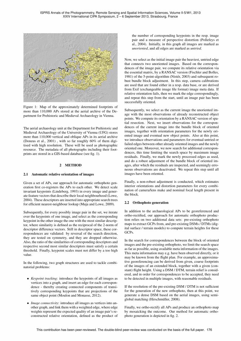
Figure 1: Map of the approximately determined footprints ofmore than 110,000 APs stored at the aerial archive of the De-partment for Prehistoric and Medieval Archaeology in Vienna.
The aerial archaeology unit at the Department for Prehistoric andMedieval Archaeology of the University of Vienna (UFG) storesmore than 110,000 vertical and oblique APs in its aerial archive(Doneus et al., 2001) , with so far roughly 60% of them digi-tised with high resolution. These will be used as photographicresource. The metadata of all photographs including their foot-prints are stored in a GIS-based database (see fig. 1).
2 METHOD
2.1 Automatic relative orientation of images
Given a set of APs, our approach for automatic orthophoto gen-eration first co-registers the APs to each other. We detect scaleinvariant keypoints (Lindeberg, 1993) in every image and gener-ate feature vectors that describe their local neighbourhood (Lowe,2004). These descriptors are inserted into appropriate search treesfor efficient nearest-neighbour lookup (Muja and Lowe, 2009).
Subsequently, for every possibly image pair in the set, we iterateover the keypoints of one image, and select as the correspondingkeypoint in the other image the one with the most similar descrip-tor, where similarity is defined as the reciprocal of the 2-norm ofdescriptor difference vectors. Still in descriptor space, these cor-respondences are validated: by reversal of the search direction,they are tested on symmetry, and they are dropped otherwise.Also, the ratio of the similarities of corresponding descriptors andrespective second most similar descriptors must satisfy a certainthreshold. Finally, keypoint scales must not differ by a too highvalue.
In the following, two graph structures are used to tackle combi-natorial problems:
• Keypoint tracking: introduce the keypoints of all images asvertices into a graph, and insert an edge for each correspon-dence - thereby creating connected components of transi-tively corresponding keypoints that are projections of thesame object point (Moulon and Monasse, 2012).
• Image connectivity: introduce all images as vertices into an-other graph, and link them with a weighted edge, where edgeweights represent the expected quality of an image pair’s re-constructed relative orientation, defined as the product of
the number of corresponding keypoints in the resp. imagepair and a measure of perspective distortion (Pollefeys etal., 2004). Initially, in this graph all images are marked asunoriented, and all edges are marked as untried.
Now, we select as the initial image pair the heaviest, untried edgethat connects two unoriented images. Based on the correspon-dences of the image pair, we compute its relative orientation viathe essential matrix, by a RANSAC version (Fischler and Bolles,1981) of the 5-point-algorithm (Nister, 2003) and subsequent ro-bust bundle block adjustment. In this step, camera calibrationsare used that are found either in a resp. data base, or are derivedfrom Exif (exchangeable image file format) image meta data. Ifrelative orientation fails, then we mark the edge correspondingly,and repeat this step from the start, until an image pair has beensuccessfully oriented.
Subsequently, we select as the current image the unoriented im-age with the most observations of already reconstructed objectpoints. We compute its orientation by a RANSAC version of spa-tial resection. Next, we insert observations for the correspon-dences of the current image into the bundle block of orientedimages, together with orientation parameters for the newly ori-ented image and eventual new object points. Also at this point,we introduce observations and parameters for eventual untried orfailed edges between other already oriented images and the newlyoriented one. Moreover, we now search for additional correspon-dences, this time limiting the search space by maximum imageresiduals. Finally, we mark the newly processed edges as used,and do a robust adjustment of the bundle block of oriented im-ages, after which the residuals are inspected, and seemingly erro-neous observations are deactivated. We repeat this step until allimages have been oriented.
Finally, a non-robust adjustment is conducted, which estimatesinterior orientations and distortion parameters for every combi-nation of camera/lens make and nominal focal length present inthe block.
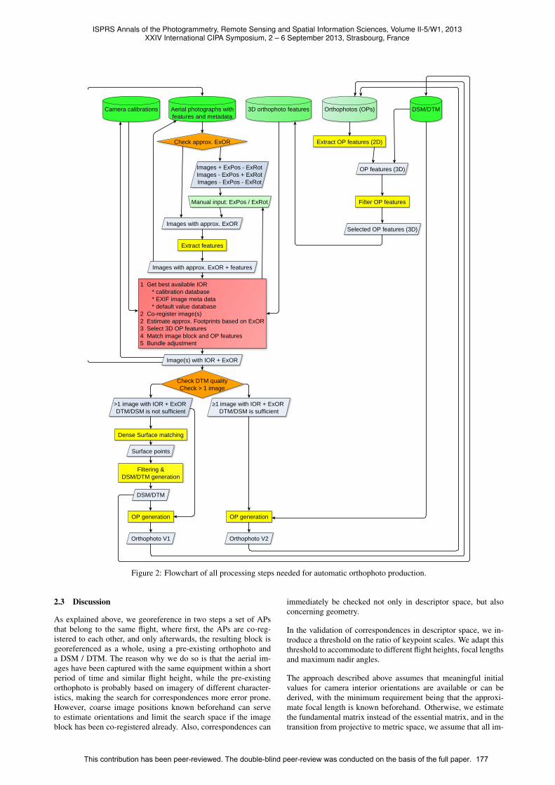
2.2 Orthophoto generation
In addition to the archaeological APs to be georeferenced andortho-rectified, our approach for automatic orthophoto produc-tion relies on two additional data sets: pre-existing orthophotomaps to extract GCPs from, and pre-existing DSMs / DTMs (dig-ital surface / terrain models) to compute terrain heights for theseGCPs.
In the search for correspondences between the block of orientedimages and the pre-existing orthophoto, we limit the search spaceas far as possible, using available meta information of the images.This meta information may e.g. have been observed directly, or itmay be known from the flight plan. For example, an approxima-tive georeferencing can be derived from given, coarse footprintsof the images of an extended block, together with a given (con-stant) flight height. Using a DSM / DTM, terrain relief is consid-ered, and in order for correspondences to be accepted, they needto be detected in multiple images, with reasonable residuals.
If the resolution of the pre-existing DSM / DTM is not sufficientfor the generation of the new orthophoto, then at this point, wegenerate a dense DSM based on the aerial images, using semi-global matching (Hirschmuller, 2008).
Finally, we ortho-rectify all APs and produce an orthophoto mapby mosaicking the outcome. Our method for automatic ortho-photo generation is depicted in fig. 2.
ISPRS Annals of the Photogrammetry, Remote Sensing and Spatial Information Sciences, Volume II-5/W1, 2013XXIV International CIPA Symposium, 2 – 6 September 2013, Strasbourg, France
This contribution has been peer-reviewed. The double-blind peer-review was conducted on the basis of the full paper. 176
Aerial photographs withfeatures and metadata
Camera calibrations
Check approx. ExOR
Images with approx. ExOR
Images + ExPos - ExRotImages - ExPos + ExRotImages - ExPos - ExRot
Manual input: ExPos / ExRot
Orthophotos (OPs) DSM/DTM
Extract OP features (2D)
OP features (3D)
Filter OP features
Selected OP features (3D)
Extract features
1 Get best available IOR * calibration database * EXIF image meta data * default value database2 Co-register image(s)2 Estimate approx. Footprints based on ExOR3 Select 3D OP features4 Match image block and OP features5 Bundle adjustment
Image(s) with IOR + ExOR
Dense Surface matching
Surface points
Filtering &DSM/DTM generation
DSM/DTM
OP generation
Orthophoto V1
OP generation
Orthophoto V2
Images with approx. ExOR + features
3D orthophoto features
Check DTM qualityCheck > 1 image
≥1 image with IOR + ExORDTM/DSM is sufficient
>1 image with IOR + ExOR DTM/DSM is not sufficient
Figure 2: Flowchart of all processing steps needed for automatic orthophoto production.
2.3 Discussion
As explained above, we georeference in two steps a set of APsthat belong to the same flight, where first, the APs are co-reg-istered to each other, and only afterwards, the resulting block isgeoreferenced as a whole, using a pre-existing orthophoto anda DSM / DTM. The reason why we do so is that the aerial im-ages have been captured with the same equipment within a shortperiod of time and similar flight height, while the pre-existingorthophoto is probably based on imagery of different character-istics, making the search for correspondences more error prone.However, coarse image positions known beforehand can serveto estimate orientations and limit the search space if the imageblock has been co-registered already. Also, correspondences can
immediately be checked not only in descriptor space, but alsoconcerning geometry.
In the validation of correspondences in descriptor space, we in-troduce a threshold on the ratio of keypoint scales. We adapt thisthreshold to accommodate to different flight heights, focal lengthsand maximum nadir angles.
The approach described above assumes that meaningful initialvalues for camera interior orientations are available or can bederived, with the minimum requirement being that the approxi-mate focal length is known beforehand. Otherwise, we estimatethe fundamental matrix instead of the essential matrix, and in thetransition from projective to metric space, we assume that all im-
ISPRS Annals of the Photogrammetry, Remote Sensing and Spatial Information Sciences, Volume II-5/W1, 2013XXIV International CIPA Symposium, 2 – 6 September 2013, Strasbourg, France
This contribution has been peer-reviewed. The double-blind peer-review was conducted on the basis of the full paper. 177
ages share the same interior orientation. If the terrain featuresenough relief, then separate interior orientations can still be esti-mated for each image in the bundle block adjustment.
Also, the approach is tailored to digital images. For historic im-agery captured with photographic film, an additional step can beintroduced, which detects fiducial marks and transforms the im-age coordinates into the camera frame.
So far, we use image pairs for the computation of initial relativeorientations, which limit geometrically valid correspondences toa narrow band around the resp. epipolar line. Relatively orientedimage triples define two epipolar lines for each image correspon-dence, which generally intersect in an image point. Thus, usageof image triples allows for a more robust outlier detection andhence, a more robust initial relative orientation. However, it alsointroduces a higher level of complexity concerning computationtimes and implementation.
In our approach, we propose the usage of point-like features.However, for the search of correspondences between the aerialimage block and the pre-existing orthophoto, usage of feature re-gions seems to be promising.
3 STRUCTURE
We develop OrientAL in two computer languages: C/C++ andPython, and we choose the language of implementation accordingto the task needed to solve: C/C++ for low-level, performance-critical functionality, and Python for high-level functions. Imple-mentations in Python feature the benefits of being easily read-able, debuggable and adaptable by end-users (for study, experi-mentation, or due to special needs) on the one hand, and of thelarge amount of high-level functionality (e.g. for visualization)available in Python on the other hand. Binding C/C++ librariesto Python introduces additional development costs, but Pythonbindings provide an easily accessible way for end-users to inte-grate OrientAL into custom scripts.
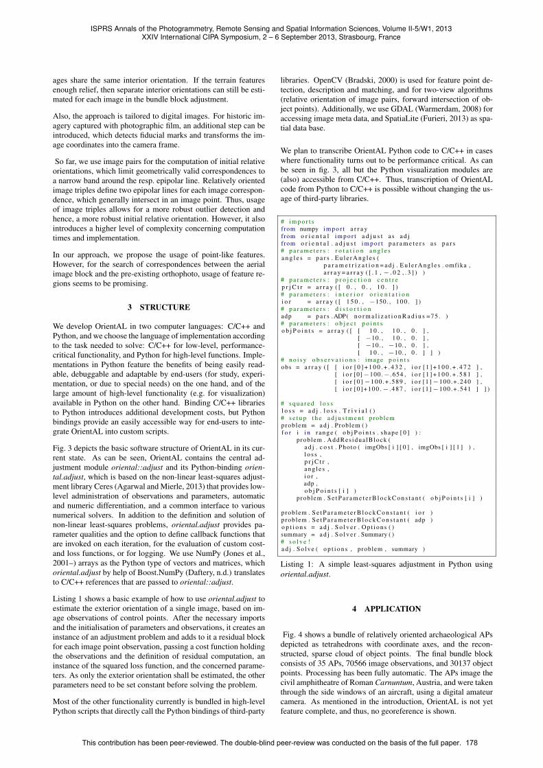
Fig. 3 depicts the basic software structure of OrientAL in its cur-rent state. As can be seen, OrientAL contains the central ad-justment module oriental::adjust and its Python-binding orien-tal.adjust, which is based on the non-linear least-squares adjust-ment library Ceres (Agarwal and Mierle, 2013) that provides low-level administration of observations and parameters, automaticand numeric differentiation, and a common interface to variousnumerical solvers. In addition to the definition and solution ofnon-linear least-squares problems, oriental.adjust provides pa-rameter qualities and the option to define callback functions thatare invoked on each iteration, for the evaluation of custom cost-and loss functions, or for logging. We use NumPy (Jones et al.,2001–) arrays as the Python type of vectors and matrices, whichoriental.adjust by help of Boost.NumPy (Daftery, n.d.) translatesto C/C++ references that are passed to oriental::adjust.
Listing 1 shows a basic example of how to use oriental.adjust toestimate the exterior orientation of a single image, based on im-age observations of control points. After the necessary importsand the initialisation of parameters and observations, it creates aninstance of an adjustment problem and adds to it a residual blockfor each image point observation, passing a cost function holdingthe observations and the definition of residual computation, aninstance of the squared loss function, and the concerned parame-ters. As only the exterior orientation shall be estimated, the otherparameters need to be set constant before solving the problem.
Most of the other functionality currently is bundled in high-levelPython scripts that directly call the Python bindings of third-party
libraries. OpenCV (Bradski, 2000) is used for feature point de-tection, description and matching, and for two-view algorithms(relative orientation of image pairs, forward intersection of ob-ject points). Additionally, we use GDAL (Warmerdam, 2008) foraccessing image meta data, and SpatiaLite (Furieri, 2013) as spa-tial data base.
We plan to transcribe OrientAL Python code to C/C++ in caseswhere functionality turns out to be performance critical. As canbe seen in fig. 3, all but the Python visualization modules are(also) accessible from C/C++. Thus, transcription of OrientALcode from Python to C/C++ is possible without changing the us-age of third-party libraries.
# i m p o r t sfrom numpy i m p o r t a r r a yfrom o r i e n t a l i m p o r t a d j u s t a s a d jfrom o r i e n t a l . a d j u s t i m p o r t p a r a m e t e r s a s p a r s# p a r a m e t e r s : r o t a t i o n a n g l e sa n g l e s = p a r s . E u l e r A n g l e s (
p a r a m e t r i z a t i o n = a d j . E u l e r A n g l e s . omfika ,a r r a y = a r r a y ( [ . 1 , − . 0 2 , . 3 ] ) )
# p a r a m e t e r s : p r o j e c t i o n c e n t r ep r j C t r = a r r a y ( [ 0 . , 0 . , 1 0 . ] )# p a r a m e t e r s : i n t e r i o r o r i e n t a t i o ni o r = a r r a y ( [ 1 5 0 . , −150. , 1 0 0 . ] )# p a r a m e t e r s : d i s t o r t i o nadp = p a r s .ADP( n o r m a l i z a t i o n R a d i u s =75 . )# p a r a m e t e r s : o b j e c t p o i n t so b j P o i n t s = a r r a y ( [ [ 1 0 . , 1 0 . , 0 . ] ,
[ −10. , 1 0 . , 0 . ] ,[ −10. , −10. , 0 . ] ,[ 1 0 . , −10. , 0 . ] ] )
# n o i s y o b s e r v a t i o n s : image p o i n t sobs = a r r a y ( [ [ i o r [ 0 ] + 1 0 0 . + . 4 3 2 , i o r [ 1 ] + 1 0 0 . + . 4 7 2 ] ,
[ i o r [0]−100.− .654 , i o r [ 1 ] + 1 0 0 . + . 5 8 1 ] ,[ i o r [0 ]−100 .+ .589 , i o r [1]−100.+ .240 ] ,[ i o r [0 ]+100 .− . 487 , i o r [1]−100.+ .541 ] ] )
# s q u a r e d l o s sl o s s = a d j . l o s s . T r i v i a l ( )# s e t u p t h e a d j u s t m e n t problemproblem = a d j . Problem ( )f o r i i n r a n g e ( o b j P o i n t s . shape [ 0 ] ) :
problem . AddRes idua lBlock (a d j . c o s t . Photo ( imgObs [ i ] [ 0 ] , imgObs [ i ] [ 1 ] ) ,l o s s ,p r j C t r ,a n g l e s ,i o r ,adp ,o b j P o i n t s [ i ] )
problem . S e t P a r a m e t e r B l o c k C o n s t a n t ( o b j P o i n t s [ i ] )
problem . S e t P a r a m e t e r B l o c k C o n s t a n t ( i o r )problem . S e t P a r a m e t e r B l o c k C o n s t a n t ( adp )o p t i o n s = a d j . S o l v e r . O p t i o n s ( )summary = a d j . S o l v e r . Summary ( )# s o l v e !a d j . So lve ( o p t i o n s , problem , summary )
Listing 1: A simple least-squares adjustment in Python usingoriental.adjust.
4 APPLICATION
Fig. 4 shows a bundle of relatively oriented archaeological APsdepicted as tetrahedrons with coordinate axes, and the recon-structed, sparse cloud of object points. The final bundle blockconsists of 35 APs, 70566 image observations, and 30137 objectpoints. Processing has been fully automatic. The APs image thecivil amphitheatre of Roman Carnuntum, Austria, and were takenthrough the side windows of an aircraft, using a digital amateurcamera. As mentioned in the introduction, OrientAL is not yetfeature complete, and thus, no georeference is shown.
ISPRS Annals of the Photogrammetry, Remote Sensing and Spatial Information Sciences, Volume II-5/W1, 2013XXIV International CIPA Symposium, 2 – 6 September 2013, Strasbourg, France
This contribution has been peer-reviewed. The double-blind peer-review was conducted on the basis of the full paper. 178

IPythongrid computing
Python Interpreterscripting, interactive use
Python IDEDevelopment, debugging
orientalhigh-level
Python scripts
boost::numpyreference NumPy
arrays in C++
boost::pythonC++ extensions
for Python
oriental.adjustPython-binding
for oriental::adjust
Callbacks
NumPymultidimensional arrays,
linear algebra
GDALgeoreferenced image I/O,
image processing
matplotlib2D plots
mayavi3D plots
OpenCVimage I/O,
image processing,analysis,
understanding
oriental::adjustcentral
adjustment module
Callbacks
VTK3D graphics
using OpenGL
Qtmulti-
platformapplicationframework
PySide
SQLiteACID-compliant
in-processRDBMS
orientalcommon structures
and utilities
Ceresnon-linear least squares
problems solver
Callbacks
boostvarioususeful
C++ libs.
Callbacks
SuiteSparseAMDCAMD
CCOLAMDCHOLMODCOLAMDCXSPARSE
sparse numerical solver
glogGoogle's
logging lib.
Eigenlinear algebra
by C++template expressions
OpenMPopen API for shared memory
multi-processing on CPU
SpatiaLiteSpatial
extensionfor SQLite
OpenCLopen API for parallel programming
on CPU and GPU
TBBshared memorymultiprocessing
on CPU
OpenGLmulti-platform
GPU API
OpenBLASopen implementation of
BLAS and LAPACK routines
Figure 3: Call graph of modules involved with OrientAL; green frame : modules accessible from Python; yellow fill : modulesaccessible from C/C++; dashed edges: optional modules;
5 CONLUSIONS AND FUTURE WORK
An archaeological case study will serve to test and evaluateall proposed solutions for automated orthophoto generation. Theproposed 250 km2 large area in the eastern part of Lower Austriaseems to be very promising both archaeologically and in termsof software testing. It is largely covered by vertical and obliqueAPs from various years and seasons, with scales ranging from1:25,000 to 1:5,000. The evaluation should identify problemsand improve our approach, both using conventional aeroplanesas well as UAVs.
We firmly believe that the expected results will be of high impor-tance for the archaeological discipline and beyond. By provid-ing archaeologists with easily implementable methods for aerialphoto rectification, the enormous amount of valuable informationon archaeological landscapes will be accessible to mapping. Thiscould have a dramatic effect on the future archaeological process,where accurate, detailed and coherent GIS-based maps of wholeregions can add important information for directing archaeologi-cal research and cultural heritage management.
ACKNOWLEDGEMENTS
This research is being carried out with the financial support of theAustrian Science Fund (FWF): P24116-N23.
The Ludwig Boltzmann Institute for Archaeological Prospectionand Virtual Archaeology (http://www.archpro.lbg.ac.at/)is based on an international cooperation of the Ludwig Boltz-mann Gesellschaft (A), the University of Vienna (A), the ViennaUniversity of Technology (A), the Austrian Central Institute forMeteorology and Geodynamics (A), the office of the provincialgovernment of Lower Austria (A), Airborne Technologies GmbH(A), RGZM-Roman-Germanic Central Museum Mainz (D), RA-Swedish National Heritage Board (S), IBM VISTA-University ofBirmingham (GB) and NIKU-Norwegian Institute for CulturalHeritage Research (N).
REFERENCES
Agarwal, S. and Mierle, K., 2013. Ceres Solver: Tutorial & Ref-erence. Google Inc.
Agisoft, 2013. Agisoft Photoscan Professional Edition. http:
//www.agisoft.ru/products/photoscan/professional/
Accessed on 09 April 2013.
ISPRS Annals of the Photogrammetry, Remote Sensing and Spatial Information Sciences, Volume II-5/W1, 2013XXIV International CIPA Symposium, 2 – 6 September 2013, Strasbourg, France
This contribution has been peer-reviewed. The double-blind peer-review was conducted on the basis of the full paper. 179
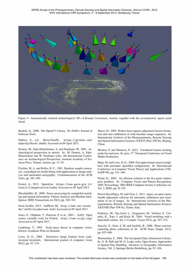
Figure 4: Automatically oriented archaeological APs of Roman Carnuntum, Austria, together with the reconstructed, sparse pointcloud.
Bradski, G., 2000. The OpenCV Library. Dr. Dobb’s Journal ofSoftware Tools.
Daftery, A., n.d. Boost.NumPy. https://github.com/
ndarray/Boost.NumPy Accessed on 09 April 2013.
Doneus, M., Eder-Hinterleitner, A. and Neubauer, W., 2001. Ar-chaeological prospection in austria. In: M. Doneus, A. Eder-Hinterleitner and W. Neubauer (eds), 4th International Confer-ence on Archaeological Prospection, Austrian Academy of Sci-ences Press, Vienna, Austria, pp. 11–34.
Fischler, M. A. and Bolles, R. C., 1981. Random sample consen-sus: a paradigm for model fitting with applications to image anal-ysis and automated cartography. Communications of the ACM24(6), pp. 381–395.
Furieri, A., 2013. SpatiaLite. https://www.gaia-gis.it/
fossil/libspatialite/index Accessed on 09 April 2013.
Hirschmuller, H., 2008. Stereo processing by semiglobal match-ing and mutual information. Pattern Analysis and Machine Intel-ligence, IEEE Transactions on 30(2), pp. 328–341.
Irwin Scollar, 2013. AirPhoto SE. http://www.uni-koeln.
de/~al001/airphotose.html Accessed on 09 April 2013.
Jones, E., Oliphant, T., Peterson, P. et al., 2001–. SciPy: Opensource scientific tools for Python. http://www.scipy.org/
Accessed on 09 April 2013.
Lindeberg, T., 1993. Scale-space theory in computer vision.Kluwer Academic Print on Demand.
Lowe, D. G., 2004. Distinctive image features from scale-invariant keypoints. International journal of computer vision60(2), pp. 91–110.
Mayer, H., 2005. Robust least-squares adjustment based orienta-tion and auto-calibration of wide-baseline image sequences. In:International Archives of the Photogrammetry, Remote Sensingand Spatial Information Sciences XXXVI (Part 3/W36), Beijing,China.
Moulon, P. and Monasse, P., 2012. Unordered feature trackingmade fast and easy. In: proc. 9th European Conference on VisualMedia Production.
Muja, M. and Lowe, D. G., 2009. Fast approximate nearest neigh-bors with automatic algorithm configuration. In: InternationalConference on Computer Vision Theory and Applications (VIS-SAPP’09), pp. 331–340.
Nister, D., 2003. An efficient solution to the five-point relativepose problem. In: Computer Vision and Pattern Recognition,2003. Proceedings. 2003 IEEE Computer Society Conference on,Vol. 2, IEEE, pp. II–195.
Pierrot Deseilligny, M. and Clery, I., 2011. Apero, an open sourcebundle adjusment software for automatic calibration and orien-tation of set of images. In: International Archives of the Pho-togrammetry, Remote Sensing and Spatial Information SciencesXXXVIII (Part 5/W16), Trento, Italy.
Pollefeys, M., Van Gool, L., Vergauwen, M., Verbiest, F., Cor-nelis, K., Tops, J. and Koch, R., 2004. Visual modeling with ahand-held camera. Int. J. Comput. Vision 59(3), pp. 207–232.
Snavely, N., Seitz, S. M. and Szeliski, R., 2006. Photo tourism:exploring photo collections in 3d. ACM Trans. Graph. 25(3),pp. 835–846.
Warmerdam, F., 2008. The Geospatial Data Abstraction Library.In: G. B. Hall and M. G. Leahy (eds), Open Source Approachesin Spatial Data Handling, Advances in Geographic InformationScience, Vol. 2, Springer Berlin Heidelberg, pp. 87–104.
ISPRS Annals of the Photogrammetry, Remote Sensing and Spatial Information Sciences, Volume II-5/W1, 2013XXIV International CIPA Symposium, 2 – 6 September 2013, Strasbourg, France
This contribution has been peer-reviewed. The double-blind peer-review was conducted on the basis of the full paper. 180