QUATERNARY OIL GEOLOGICAL STRATIGRAPHY IN … · The quaternary geological stratigraphy in Greece...
8
856 ∆ελτίο της Ελληνικής Γεωλογικής Εταιρίας τομ. XXXVI, 2004 Πρακτικά 10 ου ∆ιεθνούς Συνεδρίου, Θεσ/νίκη Απρίλιος 2004 Bulletin of the Geological Society of Greece vol. XXXVI, 2004 Proceedings of the 10 th International Congress, Thessaloniki, April 2004 QUATERNARY SOIL-GEOLOGICAL STRATIGRAPHY IN GREECE Paepe R. 1 , Mariolakos I. 2 , Van Overloop E. 1 , Nassopoulou S. 3 , Hus J. 4 , Hatziotou M. 5 , Markopoulos T. 6 , Manutsoglu E. 6 , Livaditis G. 7 , Sabot V. 7 1 Environmental Research and Geological Consultants GEOBOUND INTERNATIONAL, Herzele, Belgium [email protected] and Free University of Brussels, Belgium 2 Department Geodynamic Geology, National and Kapodistrian University of Athens, Athens, Greece [email protected] 3 Ministry of Environment, Athens, Greece [email protected] 4 Centre de physique du globe, Institut royal de météorologie, Dourbes, Belgique 5 Greek Archaeological Survey, Athens, Greece 6 Mineralogical Resources and Engineering Department, Technical University of Crete, Chania, Crete, Greece [email protected], [email protected] 7 Department of Geography, Athens, National and Kapodistrian University of Athens, Greece ABSTRACT Peloponnesus and Crete are probably offering the best possible standard sections for Eastern Mediterranean Pleistocene Series. Complete Pleistocene Standard Lithostratigraphic Sections from Sparta (Peloponnesus) and Kandanos (Crete) reveal continuous Pleistocene Land Sequences composed of cyclic palaeosol levels interfering with clastic fluvial, eolian (loess) and gravel deposits comparable with analogues found elswhere over the earth. Most suitable for correlation are: a) the standard loess area of Northern Europe, Russia and China, and b) the subtropical and tropical re- gions of Africa and Asia. The standard Greek Pleistocene Lithostratigraphic Sequence independ- ently recorded at both sites (and partially from sites in other regions of Greece) reveal a number of 103 palaeosols of both interglacial and interstadial stages, indicating the extreme warm to relative warm phases of the Pleistocene ice age. This number suits surprisingly well to the 103 levels of the equally warm odd numbered oxygen isotopic stages (OIS) of the Pleistocene deep sea record which equally encompass the warm phases of the Pleistocene. Special attention is given to the Upper Pleistocene of Koroni (Southern Peloponnesus) as a case study for the Last Interglacial – Last Glacial Cycle, i.e. the middle term cycle extending in time from 127 Ka (thousand years) till 10 Ka or beginning of the Holocene. It stands as a model for the recur- rent 100 Ka cycles of the long term overall Pleistocene record. Finally, in addition to the Pleisto- cene, the twenty wet – dry cycles of the Holocene are reviewed. 1 THE SOIL STRATIGRAPHIC PLEISTOCENE RECORD IN GREECE The Quaternary in this contribution is essentially dealing with the long-term record of Pleistocene of 2.4 Ma (million years). The quaternary geological stratigraphy in Greece displays a time series of 103 (interglacial and interstadial) fossil soil (palaeosol) levels from which the climate-environmental conditions with respect to their development can be enhanced. Hence, soil-geological stratigraphy is an important tool in the understanding of the climatic evolution of the Quaternary. 1.1 Why a soil-stratigraphic based Quaternary geology? 1. After the ‘Mediterranean Salinity Crisis’ in Late Messinian times, due to tectonic events that cut off the Mediterranean Sea from the Atlantic Ocean, the region became isolated and climatically more continental.
Transcript of QUATERNARY OIL GEOLOGICAL STRATIGRAPHY IN … · The quaternary geological stratigraphy in Greece...
856
∆ελτίο της Ελληνικής Γεωλογικής Εταιρίας τοµ. XXXVI, 2004 Πρακτικά 10ου ∆ιεθνούς Συνεδρίου, Θεσ/νίκη Απρίλιος 2004
Bulletin of the Geological Society of Greece vol. XXXVI, 2004 Proceedings of the 10th International Congress, Thessaloniki, April 2004
QUATERNARY SOIL-GEOLOGICAL STRATIGRAPHY IN GREECE Paepe R.1, Mariolakos I.2, Van Overloop E.1, Nassopoulou S.3, Hus J.4, Hatziotou M.5, Markopoulos T.6, Manutsoglu E.6, Livaditis G.7, Sabot V. 7 1 Environmental Research and Geological Consultants GEOBOUND INTERNATIONAL, Herzele, Belgium [email protected] and Free University of Brussels, Belgium 2 Department Geodynamic Geology, National and Kapodistrian University of Athens, Athens, Greece [email protected] 3 Ministry of Environment, Athens, Greece [email protected] 4 Centre de physique du globe, Institut royal de météorologie, Dourbes, Belgique 5 Greek Archaeological Survey, Athens, Greece 6 Mineralogical Resources and Engineering Department, Technical University of Crete, Chania, Crete, Greece [email protected], [email protected] 7 Department of Geography, Athens, National and Kapodistrian University of Athens, Greece
ABSTRACT
Peloponnesus and Crete are probably offering the best possible standard sections for Eastern Mediterranean Pleistocene Series. Complete Pleistocene Standard Lithostratigraphic Sections from Sparta (Peloponnesus) and Kandanos (Crete) reveal continuous Pleistocene Land Sequences composed of cyclic palaeosol levels interfering with clastic fluvial, eolian (loess) and gravel deposits comparable with analogues found elswhere over the earth. Most suitable for correlation are: a) the standard loess area of Northern Europe, Russia and China, and b) the subtropical and tropical re-gions of Africa and Asia. The standard Greek Pleistocene Lithostratigraphic Sequence independ-ently recorded at both sites (and partially from sites in other regions of Greece) reveal a number of 103 palaeosols of both interglacial and interstadial stages, indicating the extreme warm to relative warm phases of the Pleistocene ice age. This number suits surprisingly well to the 103 levels of the equally warm odd numbered oxygen isotopic stages (OIS) of the Pleistocene deep sea record which equally encompass the warm phases of the Pleistocene.
Special attention is given to the Upper Pleistocene of Koroni (Southern Peloponnesus) as a case study for the Last Interglacial – Last Glacial Cycle, i.e. the middle term cycle extending in time from 127 Ka (thousand years) till 10 Ka or beginning of the Holocene. It stands as a model for the recur-rent 100 Ka cycles of the long term overall Pleistocene record. Finally, in addition to the Pleisto-cene, the twenty wet – dry cycles of the Holocene are reviewed.
1 THE SOIL STRATIGRAPHIC PLEISTOCENE RECORD IN GREECE
The Quaternary in this contribution is essentially dealing with the long-term record of Pleistocene of 2.4 Ma (million years). The quaternary geological stratigraphy in Greece displays a time series of 103 (interglacial and interstadial) fossil soil (palaeosol) levels from which the climate-environmental conditions with respect to their development can be enhanced. Hence, soil-geological stratigraphy is an important tool in the understanding of the climatic evolution of the Quaternary. 1.1 Why a soil-stratigraphic based Quaternary geology?
1. After the ‘Mediterranean Salinity Crisis’ in Late Messinian times, due to tectonic events that cut off the Mediterranean Sea from the Atlantic Ocean, the region became isolated and climatically more continental.
857
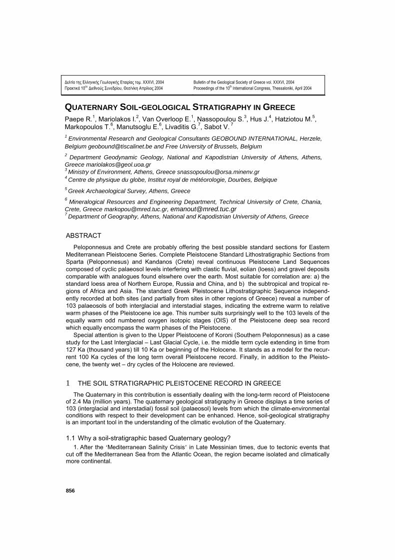
2. The Quaternary Greek land record based on soil series, as will be described in detail hereaf-ter, thus became essentially a non marine system providing fluvial and desertic sediment series al-ternating with (fossil) soils. They are called ‘Geosoil’ to stress their geological affinity (Paepe et al. 1990).
Figure 1. GEOSOIL: The interface between Biosphere and Lithosphere. Top of lithosphere reworked into Pe-dosphere (soil-sphere). Truncated pedosphere becomes geosoil. Atmospheric climatic changes via biosphere in pedosphere. GEOSOIL registers changes in atmosphere through time such as carbon dioxide changes.
3. Geosoils in Quaternary time series of lithostratigraphic sequences reveal to occupy ‘time sta-
ble’ stratigraphic positions and thus also suitable for time correlation just as the marine series. 4. Because Quaternary geosoil records also show worldwide a stable stratigraphic distribution,
they are suitable for long distance correlation. 5. Geosoil-sediment series can therefore also offer good evidence of worldwide climatic
changes on land throughout the Quaternary Period. 6. Geosoils reflect changes in the local bio-environment as well as changes in the atmospheric
chemistry (carbon dioxide). 7. The Greek soil-stratigraphic standard sequence (as described hereafter) reveals a total of
103 such fossil geo-soils, both interglacial and glacial-interstadial. They all occur above the basal Miocene Red Latosol and can be correlated with the 103 oxygen isotopic deep-sea record occur-ring above the geomagnetic Gauss/Matuyama boundary of 2.6 Ma (Shackleton et al. 1990).
1.2 Two important lithostratigraphic type-localities as a proposal for a Greek Land
Quaternary Lithostratigraphic Record Amongst numerous lithostratigraphic sections observed all over Greece during the last twenty
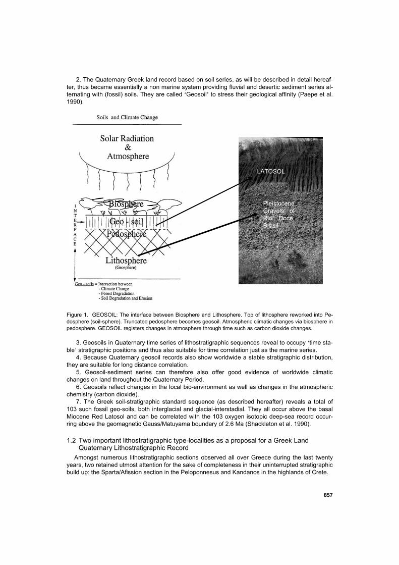
years, two retained utmost attention for the sake of completeness in their uninterrupted stratigraphic build up: the Sparta/Afission section in the Peloponnesus and Kandanos in the highlands of Crete.
LATOSOL
Pleistocene Gravels of Rio Doce, Brasil
858
1.2.1 Section Sparta/Afission
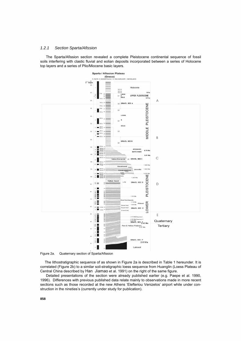
The Sparta/Afission section revealed a complete Pleistocene continental sequence of fossil soils interfering with clastic fluvial and eolian deposits incorporated between a series of Holocene top layers and a series of Plio/Miocene basic layers.
Figure 2a. Quaternary section of Sparta/Afission
The lithostratigraphic sequence of as shown in Figure 2a is described in Table 1 hereunder. It is
correlated (Figure 2b) to a similar soil-stratigraphic loess sequence from Huanglin (Loess Plateau of Central China described by Han Jiamao et al. 1991) on the right of the same figure.
Detailed presentations of the section were already published earlier (e.g. Paepe et al. 1990, 1996). Differences with previous published data relate mainly to observations made in more recent sections such as those recorded at the new Athens ‘Elefteriou Venizelos’ airport while under con-struction in the nineties’s (currently under study for publication).
859
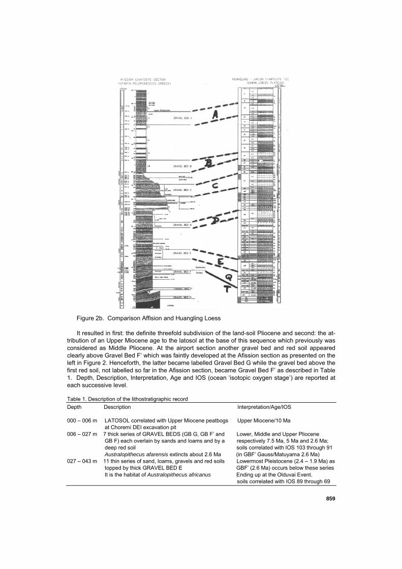
Figure 2b. Comparison Affision and Huangling Loess It resulted in first: the definite threefold subdivision of the land-soil Pliocene and second: the at-
tribution of an Upper Miocene age to the latosol at the base of this sequence which previously was considered as Middle Pliocene. At the airport section another gravel bed and red soil appeared clearly above Gravel Bed F’ which was faintly developed at the Afission section as presented on the left in Figure 2. Henceforth, the latter became labelled Gravel Bed G while the gravel bed above the first red soil, not labelled so far in the Afission section, became Gravel Bed F’ as described in Table 1. Depth, Description, Interpretation, Age and IOS (ocean ‘isotopic oxygen stage’) are reported at each successive level. Table 1. Description of the lithostratigraphic record Depth Description Interpretation/Age/IOS 000 – 006 m LATOSOL correlated with Upper Miocene peatbogs Upper Miocene/10 Ma at Choremi DEI excavation pit 006 – 027 m 7 thick series of GRAVEL BEDS (GB G, GB F’ and Lower, Middle and Upper Pliocene GB F) each overlain by sands and loams and by a respectively 7.5 Ma, 5 Ma and 2.6 Ma; deep red soil soils correlated with IOS 103 through 91 Australopithecus afarensis extincts about 2.6 Ma (in GBF’ Gauss/Matuyama 2.6 Ma) 027 – 043 m 11 thin series of sand, loams, gravels and red soils Lowermost Pleistocene (2.4 – 1.9 Ma) as topped by thick GRAVEL BED E GBF’ (2.6 Ma) occurs below these series It is the habitat of Australopithecus africanus Ending up at the Olduvai Event. soils correlated with IOS 89 through 69
860
043 – 064 m 14 thin series of sand, loams, gravels and red soils Middle Lower Pleistocene (1.9 – 1.4 Ma) topped by thick GRAVEL BED D soils correlated with IOS 67 through 41. Habitat of Homo habilis & Zinjanthropus 064 – 091 m 8 thin series of sand, loams, gravels and red soils Upper Lower Pleistocene (1.4 – 0,9 Ma) topped by thick GRAVEL BED C soils correlated with IOS 39 through 25 Thick eolian sands at start: 1.4 Ma Great Drought Cobb (1.99 Ma) and Jaramillo (1.07 Ma) Habitat of Homo erectus & Sinanthropus positive Events occur in these series 0.91 – 108 m 4 thin series of sands, loams, less gravels and Lower Middle Pleistocene (0.9 – 0.6 Ma) weak red soils topped by thick GRAVEL BED B soils correlated with IOS 23 through 17 indicating transitional climate from wet to drought Brunhes/Matuyama boundary at 0.79 Ma Extinction of Homo erectus & Sinanthropus 108 – 145 m 10 thick series of sands, loams, less gravels but Middle Middle Pleistocene (0.6 – 0.1 Ma) strong red soils topped by thick GRAVEL BED A soils correlated with IOS 15 through 7 Soils more widely spaced through time indicating climate changing into general drought Dawn of Homo sapiens neanderthalensis 145– 148 m 5 moderately developed soils with thin gravelly Upper Pleistocene (0.127 Ka – 10 Ka) layers in between soils correlated with IOS 5 through 3 as Detailed study is provided at Koroni section the three lowermost ones are grouped as Last Interglacial and two uppermost ones as Last Glacial Interstadials: 148– 160 m 8 moderately developed soil in alluvial sediments Holocene (Last 10 Ka or 10.000 years) Detailed study is provided at Marathon section The whole Holocene soil compound corre lates with IOS 1.
Main characteristics of the Sparta/Afission record:
Above the basal Miocene latosol overlain by Gravel Bed G, follows a threefold series of equally red latosolic-like geosoils of the Pliocene. GBF’ (containing the 2.6 Ma Gauss-Matuyama keybed) occurs in the middle of them so that Gravel Bed F on top of these Pliocene geosoils and covered by the complete sequence of the Pleistocene (and the Holocene at the very top of it) is the Plio-Pleistocene boundary.
This Plio-Pleistocene boundary is secured by two datings: first the GBF’ gravel deposit containing the Gauss/Matuyama boundary of 2.6 Ma (as is also the case in the loess of China); second the Reunion 1&2 reversals at respectively 2.15 and 2.25 Ma occur-ring right above the uppermost GBF gravel deposit. Henceforth, the beginning of the Pleistocene is estimated at 2.4 Ma. This complies with the earlier assumption of the start of the Pleistocene on land is at 2.43 Ma (Zagwijn & Paepe 1968).
The Pleistocene sequence which follows above, is composed of a sixfold cyclothem system of 6 stratigraphically spaced Gravel Beds (GB) at 400 Ka time intervals. This cycle was computed Van Overloop & Paepe (1998) on basis of the Sparta/Afission geosoil record. It encompasses the 400Ka cycle of the deepsea record. Actually, the total timespan of 6 cyclothems is 6 x 400 Ka=2.4 Ma. This landbound figure differs considerably from the marine-bound Calabrian boundary locating the Plio-Pleistocene boundary at 1.78 Ma.
Paepe et al. (1995) made an attempt to subdivide the 2.4 Ma Pleistocene record cli-matically on basis of the 400 Ka periodicity, into Climatic Superstages called respec-tively ‘Thermomers’ with warmer interglacials and ‘Cryomers’ with colder interglacials. The six cyclothems were subsequently labelled as T1 (between GB F and GB E), C1 (between GB E and GB D), T2 (between GB D and GB C), C2 (between GB C and GB B), T3 (between GB B and GB A) and finally C3 (between GB A and later). It explains the cyclic variation in intensity of the interglacials viz. interstadials every 400 Ka. The Pleistocene in Greece starts with T1, a warm cyclothem with four warm interglacials.
Correlation at the level of the six cyclothems and related geosoil series, between far distanciated sections such as of Lochuan on the Central Loess Plateau in China (Liu 1985), or as the Greek type of sedimentary sequences in the West- (Congo, Burundi, Uganda) and East-African Rifts (Tanzania) (Van Overloop & Paepe 1998), prove to be
861
quite feasible and add to confirm the time-stable character of these cycles at any place of the globe.
This ‘time-stable’ character infers moreover an extraterrestrial most probably planetary origin. Paepe et al. (1995) previously computed this geosoil time-stability to be of the order of 0.1% at the 1.000.000 time interval. This implies a possible soil-stratigraphic shift of maximum 1yr/1000yrs or 100yrs for one Milankovitch eccentricity cycle of at random 100.000 yrs. Considering that this Milankovitch eccentricity cycle corresponds to an Interglacial-Glacial cycle (similar to the Last Interglacial – Last Glacial Cycle) is inferring that all Interglacial-Glacial cycles of the long-term Pleistocene record obey to the same law of time-stability.
The question remains though why every fourth eccentricity cycle of the 400Ka cycle terminates in the deposition of a hughe gravel bed (A, B; C, D, E, F) whatever one is dealing with a thermomer or with cryomer. Such hughe gravel beds can only originate when steady rock fragmentation under desertic environmental circumstances can suf-ficiently supply such hughe amounts of basic coarse clastic material. Therefore, it is hereby assumed that the Gravel Beds infer phases of drought and cooling off which in the fourth eccentricity cycle could have been triggered by other planetary forcings such as the obliquity (41 Ka) and the precession (23 Ka) just to mention the Milankovitch cycles only. Van Overloop & Paepet (1998) is, however, suggesting that other cyclic-ities may intervene as well in addition to the classical Milankovitch cycles.
1.2.2 Section Kandanos
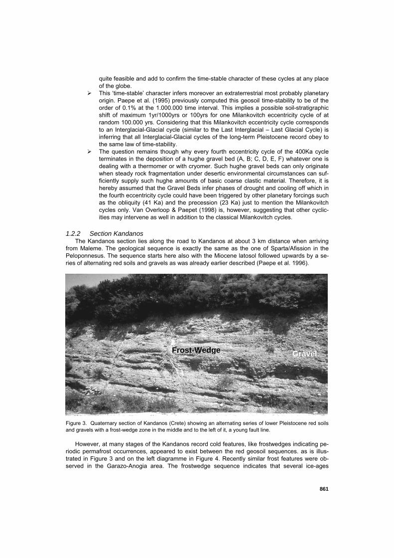
The Kandanos section lies along the road to Kandanos at about 3 km distance when arriving from Maleme. The geological sequence is exactly the same as the one of Sparta/Afission in the Peloponnesus. The sequence starts here also with the Miocene latosol followed upwards by a se-ries of alternating red soils and gravels as was already earlier described (Paepe et al. 1996).
Figure 3. Quaternary section of Kandanos (Crete) showing an alternating series of lower Pleistocene red soils and gravels with a frost-wedge zone in the middle and to the left of it, a young fault line.
However, at many stages of the Kandanos record cold features, like frostwedges indicating pe-riodic permafrost occurrences, appeared to exist between the red geosoil sequences. as is illus-trated in Figure 3 and on the left diagramme in Figure 4. Recently similar frost features were ob-served in the Garazo-Anogia area. The frostwedge sequence indicates that several ice-ages
Gravel Frost-Wedge
862
occurred throughout the Pleistocene in Crete, i.e. the most southern part of Europe (Paepe & Van Overloop 2001).
2 LONG, MIDDLE AND SHORT TERM RECORD OF THE PLEISTOCENE
2.1 Pleistocene Long Term Record (Recent till 2.4 Ma)
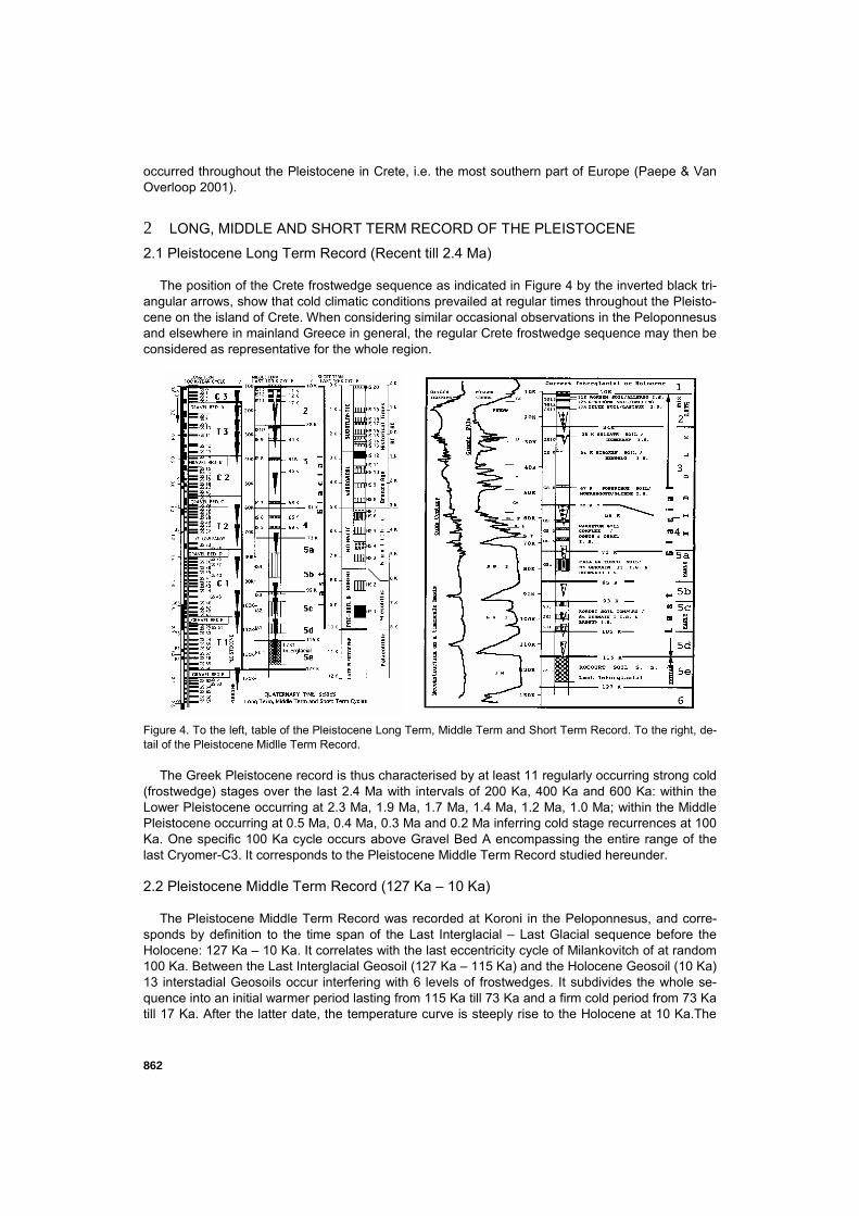
The position of the Crete frostwedge sequence as indicated in Figure 4 by the inverted black tri-angular arrows, show that cold climatic conditions prevailed at regular times throughout the Pleisto-cene on the island of Crete. When considering similar occasional observations in the Peloponnesus and elsewhere in mainland Greece in general, the regular Crete frostwedge sequence may then be considered as representative for the whole region.
Figure 4. To the left, table of the Pleistocene Long Term, Middle Term and Short Term Record. To the right, de-tail of the Pleistocene Midlle Term Record.
The Greek Pleistocene record is thus characterised by at least 11 regularly occurring strong cold
(frostwedge) stages over the last 2.4 Ma with intervals of 200 Ka, 400 Ka and 600 Ka: within the Lower Pleistocene occurring at 2.3 Ma, 1.9 Ma, 1.7 Ma, 1.4 Ma, 1.2 Ma, 1.0 Ma; within the Middle Pleistocene occurring at 0.5 Ma, 0.4 Ma, 0.3 Ma and 0.2 Ma inferring cold stage recurrences at 100 Ka. One specific 100 Ka cycle occurs above Gravel Bed A encompassing the entire range of the last Cryomer-C3. It corresponds to the Pleistocene Middle Term Record studied hereunder. 2.2 Pleistocene Middle Term Record (127 Ka – 10 Ka)
The Pleistocene Middle Term Record was recorded at Koroni in the Peloponnesus, and corre-sponds by definition to the time span of the Last Interglacial – Last Glacial sequence before the Holocene: 127 Ka – 10 Ka. It correlates with the last eccentricity cycle of Milankovitch of at random 100 Ka. Between the Last Interglacial Geosoil (127 Ka – 115 Ka) and the Holocene Geosoil (10 Ka) 13 interstadial Geosoils occur interfering with 6 levels of frostwedges. It subdivides the whole se-quence into an initial warmer period lasting from 115 Ka till 73 Ka and a firm cold period from 73 Ka till 17 Ka. After the latter date, the temperature curve is steeply rise to the Holocene at 10 Ka.The
863
trend revealed in the soil and frostwedge sequence is reflected in the pollen record of La Grande Pile in NE France, and in the ice oxygen isotopic record of Camp Century in Greenland. 2.3 Holocene Short Term Record (10 Ka)
As indicated in the third column on the left table in Figure 4, twenty alternating dryer-cooler and wetter-warmer cycles occurred within the last 10 Ka (Holocene or current interglacial) as revealed in the coastal plain of Marathon. These geological stages are encompassing the prehistorical-archaeological periods of the last 10 Ka.
3 CONCLUSION
Peloponnesus and Crete are probably offering the best possible standard sections for Eastern Mediterranean Pleistocene Series. The geological sections of Sparta/Affision (Peloponnesus) and Kandanos (Crete) revealed a complete Pleistocene land record based on soil-stratigraphic se-quences. The latter provided a Long Term and a Middle Term Pleistocene record with in addition the Holocene Short Term record on top of the stratigraphic ladder. The latter could easily be corre-lated with the archaeological chronostratigraphy of Greece.
REFERENCES Han Jiamao, J.J. Hus, R. Paepe, R.E. Vandenberghe and Liu Tungsheng, 1991. The Rock Magnetic
Properties of the Malan and Lishi Formations in the Loess Plateau of China, 30-47. In : Liu Tungsheng (eds), Environment and Global Change, Science Press, Beijing, China.
Liu, T., 1985. Central Loess Plateau in China. Proceedings Academia Sinica. Special Issue, 226pp. Zagwijn, W.H. and Paepe, R., 1968. Die Stratigraphie der Weichselzeitlichen Ablagerungen der Niederlande
und Belgiens. Eiszeitalter und Gegenwart, 19, 126-146. Paepe, R., Mariolakos, I., Van Overloop, E., and Keppens, E., 1990. Last Interglacial-Glacial Geosoil Traverse
(from stratotypes in the North Sea Basin and in the Eastern Mediterranean), Quaternary International, 5, 57-70.
Paepe, R., Hadziotou, M., and Van Overloop, E., 1995. Twenty Cyclic Pulses of Drought and Humidity during the Holocene. In : Finkl, C.W. Jnr. (ed.), Holocene Cycles. Journal of Coastal Research, Special Issue 17, 55-61.
Paepe, R., Mariolakos, I., Nassopoulou, S., Van Overloop, E., and Vouloumanos, N., 1996. Quaternary Peri-odicities of Drought in Greece. In: Angelakis, A.N. and Issar, A.S. (eds), Diachronic Climate Impacts on Wa-ter Resources, NATO ASI Series I: Global Environmental Change, Vol. 36, 77 – 110.
Paepe, R., and Van Overloop, E., 2001. Permafrost Equivalents from Boreal to Tropical Zones. In: R. Paepe and V. Melnikov (eds), Permafrost response on economic development, environmental security and natural resources, NATO ASI Series 2, Environmental Security, Vol. 76, 151-184.
Shackleton, N.J., Berger, A. and Peltier, W., 1990. An alternative astronomical calibration of the Lower Pleisto-cene time-scale based on ODP Site 677. In: Transactions Roy. Soc. Edinburgh, Earth Sciences, 81, 251-261.
Van Overloop, E., and Paepe, R., 1998. The Quaternary Geology around the Great Lakes in Central Africa. Proceedings Int. Conf. on Tropical Climatology, Meteorology and Hydrology, 142-175.