![ΠΡΟΓΡΑΜΜΑ ΠΡΟΠΟΝΗΣΗΣ ΕΝΔΥΝΑΜΩΣΗΣ ΓΙΑ ΤΟ ΣΠΙΤΙgym-kokkinotrimithia-lef.schools.ac.cy/gym-kok-nic/... · 2020-03-30 · [Bret Contreras] -- Bodyweight](https://static.fdocument.org/doc/165x107/5f4902efce7f3b701a4c4e65/oeoe-oe-gym-kokkinotrimithia-lef.jpg)
Analysis of orientation of maximum horizontal tensional ...€¦ · sedimentary basin (Gibson et...
9
Journal of Geology and Mining Research Vol. 1(3) pp. 048-056 May, 2009 Available online http://www.academicjournals.org/jgmr ©2009 Academic Journals Full Length Research Paper Analysis of orientation of maximum horizontal tensional stress (σ Hmax ) of the Gondwana Barapukuria coal basin, NW Bangladesh: By means of finite element modeling Md. Rafiqul Islam Department of Physics & Earth Sciences, University of the Ryukyus, Okinawa, 903-0213. Japan. E-mail: [email protected]. Tel: +81-080-3180-3843. Accepted 20 March, 2009 This paper uses two-dimensional Finite Element Method (FEM) numerical modeling to analyze the orientation of maximum horizontal tensional stress of the Barapukuria coal basin in Bangladesh. An elastic plane stress model incorporating elastic rock physical properties for the coal basin area was used consisting of 2916 elements with a network of 1540 nodes. The stress field at any point of the model is assumed to comprise gravitational and tectonic components. The tectonic component is assumed to act entirely in the horizontal plane in the far-field and at the model eastern boundary. Modeling results are presented in terms of four parameters, i. e. orientation of maximum horizontal tensional stress ( σ H max ), displacement vector, strain distribution, and maximum shear stress ( τ max ) contour line within the model. Results show that the orientation of the maximum horizontal tensional stress axis is almost N45 o E, which coincides with the regional stress field as studied by Gown et al. (1992), varying from N31 o E to N73 o E. Key words: Barapukuria coal basin, elastic rock properties, FE analysis, horizontal tensional stress trajectories, eastern boundary fault. INTRODUCTION Knowledge of the pre-mining state of stress especially orientation of maximum horizontal tensional stress σ H max in an intracratonic half-graben type coal basin is very important prior to any excavations being made for the recovery of coal from the subsurface. The Bara- pukuria coal basin is one of the largest half-graben type Gondwana basins in the northwest part of Bangladesh. Most of the half-graben type basins in the country are usually characterized by some major boundary faults. Wardell Armstrong (1991) resulted in an extensive network of regional seismic data that traverses a large rift boundary fault in Barapukuria basin. The boundary fault is over 5 km long, and has in excess of 200 m of throw. It is assumed that the stress field of the intracratonic, half- graben type Gondwana Barapukuria basin within Dinajpur Shield in Bangladesh (Figure 1) is largely controlled by major boundary faults, which are genetically related to local and regional tectonic activity and weak crustal rheology (Islam, 2005; Islam et al., 2009). The eastern boundary fault in Barapukuria basin is a typical feature of extensional (rift) tectonics; however, its influence on the stress field of the entire basin is not yet recognized. The state of stress of the entire basin especially the orientation of horizontal maximum principal stress is a vital issue prior to underground and/or open pit mining or coal bed methane (CBM) explorations. Numerous studies on the Barapukuria coal basin were carried out by Warddell Armstrong (1991); Bakr et al. (1996); Islam (2005); Islam and Islam (2005); Islam and Kamruzzaman (2006); Islam and Hayashi (2008a); Islam et al. (2009); Islam and Shinjo (2009), but they paid less attention with regard to the tensional stress trajectories of the basin. Wardell (1991) collected some core samples during boreholes drilling and stresses in rock were tested. It should be noted that a few measured stress values from some laboratory experiments on particular rock samples in Barapukuria coal mine area cannot reflect the entire
Transcript of Analysis of orientation of maximum horizontal tensional ...€¦ · sedimentary basin (Gibson et...
Journal of Geology and Mining Research Vol. 1(3) pp. 048-056 May, 2009 Available online http://www.academicjournals.org/jgmr ©2009 Academic Journals
Full Length Research Paper
Analysis of orientation of maximum horizontal tensional stress (σσσσHmax) of the Gondwana Barapukuria
coal basin, NW Bangladesh: By means of finite element modeling
Md. Rafiqul Islam
Department of Physics & Earth Sciences, University of the Ryukyus, Okinawa, 903-0213.
Japan. E-mail: [email protected]. Tel: +81-080-3180-3843.
Accepted 20 March, 2009
This paper uses two-dimensional Finite Element Method (FEM) numerical modeling to analyze the orientation of maximum horizontal tensional stress of the Barapukuria coal basin in Bangladesh. An elastic plane stress model incorporating elastic rock physical properties for the coal basin area was used consisting of 2916 elements with a network of 1540 nodes. The stress field at any point of the model is assumed to comprise gravitational and tectonic components. The tectonic component is assumed to act entirely in the horizontal plane in the far-field and at the model eastern boundary. Modeling results are presented in terms of four parameters, i. e. orientation of maximum horizontal tensional stress (σ H max ), displacement vector, strain distribution, and maximum shear stress ( τ max ) contour line within the model. Results show that the orientation of the maximum horizontal tensional stress axis is almost N45oE, which coincides with the regional stress field as studied by Gown et al. (1992), varying from N31oE to N73oE. Key words: Barapukuria coal basin, elastic rock properties, FE analysis, horizontal tensional stress trajectories, eastern boundary fault.
INTRODUCTION Knowledge of the pre-mining state of stress especially orientation of maximum horizontal tensional stress σ H max in an intracratonic half-graben type coal basin is very important prior to any excavations being made for the recovery of coal from the subsurface. The Bara-pukuria coal basin is one of the largest half-graben type Gondwana basins in the northwest part of Bangladesh. Most of the half-graben type basins in the country are usually characterized by some major boundary faults. Wardell Armstrong (1991) resulted in an extensive network of regional seismic data that traverses a large rift boundary fault in Barapukuria basin. The boundary fault is over 5 km long, and has in excess of 200 m of throw. It is assumed that the stress field of the intracratonic, half-graben type Gondwana Barapukuria basin within Dinajpur Shield in Bangladesh (Figure 1) is largely controlled by major boundary faults, which are genetically related to local and regional tectonic activity and weak crustal rheology (Islam, 2005; Islam et al., 2009). The
eastern boundary fault in Barapukuria basin is a typical feature of extensional (rift) tectonics; however, its influence on the stress field of the entire basin is not yet recognized.
The state of stress of the entire basin especially the orientation of horizontal maximum principal stress is a vital issue prior to underground and/or open pit mining or coal bed methane (CBM) explorations. Numerous studies on the Barapukuria coal basin were carried out by Warddell Armstrong (1991); Bakr et al. (1996); Islam (2005); Islam and Islam (2005); Islam and Kamruzzaman (2006); Islam and Hayashi (2008a); Islam et al. (2009); Islam and Shinjo (2009), but they paid less attention with regard to the tensional stress trajectories of the basin. Wardell (1991) collected some core samples during boreholes drilling and stresses in rock were tested. It should be noted that a few measured stress values from some laboratory experiments on particular rock samples in Barapukuria coal mine area cannot reflect the entire
Islam 049
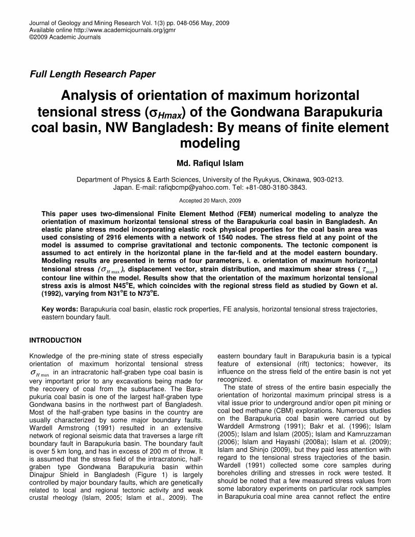
Figure 1. Location of the Barapukuria coal deposits within the physiographic divisions and in the major geotectonic features of Bangladesh. Bold lines indicate boundary of the tectonic divisions. BR, Brahmaputtra River; DP, Dinajpur Platform; NGIH, Nawabganj-Gaibandha Intracratonic High; NSP, North Slope of the Platform (part of Sud-Himalayan Foredeep) (after Khan, 1991; Khan and Chouhan, 1996; Islam and Hayashi, 2008a; Islam et al., 2009).
stress field of the basin. This paper deals with the orient-tations of maximum horizontal tensional stresses due to horizontal movement of the major eastern boundary fault and subsequent elastic deformation. In this article, it is assumed that the stress field of the half-graben type
Barapukuria coal basin is formed entirely by both the tec-tonic and gravitational stress components. The study focus on the four relative parameters (1) orientation and magnitude of maximum horizontal tensional stress σHmax , (2) displacement vector, (3) strain distribution, and (4)
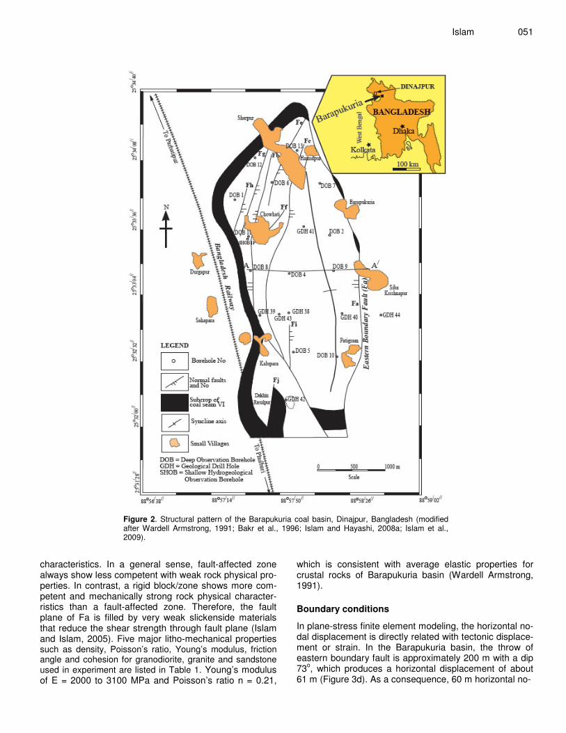
050 J. Geol. Min. Res. contour lines of maximum shear stress ( τ max ) because these parameters have significant functions with regard functions with regard to the tectonic stress field and the development of the half-graben type Barapukuria basin. Structure of the Barapukuria basin Regionally, the Barapukuria coal basin is located in the Dinajpur Shield (Figure 1) of Bangladesh and is sur-rounded by the Himalayan Foredeep to the north, the Shillong Shield/Platform to the east, and the Indian Peninsular Shield to the west (Khan, 1991; Khan and Chouhan, 1996; Alam et al., 2003; Islam and Hayashi, 2008a; Islam et al., 2009). The geologic and structural conditions of the basin were illustrated in details by Islam and Hayashi (2008a); Islam et al. (2009). Structurally, the Barapukuria basin is a long, narrow, and shallow Permo-Carboniferous intracratonic rift basin. The basin trends approximately N-S for over 5 km, ranges from 2 to 3 km wide, and is over 550 m deep. Below a prominent uncon-formity, covered by an unstructured Pleistocene through Tertiary clastic sequence, steeply dipping normal faults bound tilted half-graben fault blocks (Figure 2). The nor-thern, western, and southern boundaries of the basin are also truncated by several small-scale normal boundary faults. Major basin-bounding faults are part of a zone of crustal weakness. The faults and igneous dyke decrease the cohesion and friction angle and reduce the shear strength through fault plane and filling materials. The overall structures of the Barapukuria Basin imply a tecto-nically active highly disturbed zone (Wardell Armstrong, 1991; Bakr et al., 1996; Islam and Islam, 2005; Islam and Hayashi, 2008a; Islam et al., 2009).
The Barapukuria half-graben basin is assumed to be related to its tectonic origin. The basin area is very close (about 200 km) to the convergence boundary of the Indian and Eurasian plates. As a consequence, the far field tectonic stress field is highly significant to the struc-ture of this basin. A 5 km long Eastern Boundary Fault of the Barapukuria basin is the best structural evidence for recent tectonic activity. However, the basin geometry and its stress field are directly related to the tectonic dis-placement gradient.
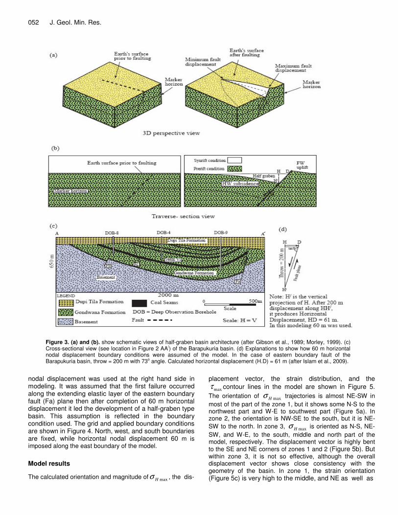
Usually, the Barapukuria-type intracratonic half-graben basin in a convergent regime is developed due to local crustal weakening, where rheology strongly affects the dynamics of basin formation (Buck, 1991; Cloetingh et al., 1995). In a gross sense, for the Barapukuria-type half-graben basin, displacement is greatest at the center of the fault and decreases to zero at the fault tips, as shown in Figure 3a. The displacement of an initially hori-zontal surface that intersects the fault is greatest at the fault itself and decreases with distance away from the fault (Figure 3b). This produces footwall uplift and hanging-wall subsidence, the later which creates the sedimentary basin (Gibson et al., 1989; Contreras et al., 1997). The structure of the Barapukuria basin is shown in
Figure 3c. It is apparent that the basin geometry is affect-ted by fault propagation and displacement is accumulated on the boundary fault. About 200 m vertical displacement occurred with 73oC dipping (Figure 3d). Along the basin the fault length is about 5 km. The fault length: vertical displacement ratio is about 25:1. About 60 m horizontal displacement (Figure 3d) indicates recent tectonic activity and the basin is developed due to 60 m horizontal dis-placement of the boundary fault towards the east (Islam et al., 2009). It is assumed that under the more steeply dipping boundary fault segments the displacement is approximately constant in Precambrian basement (Morely, 1999). Numerical modeling In this study, the Finite Element Method (FEM) was used to predict stress dependent parameters. Model was con-structed according to the state of plane stress and results were illustrated using the FE software package deve-loped by Hayashi (2008). The software package was widely used in some studies by Islam and Hayashi (2008b); Islam et al (2009); Islam and Hayashi (2009); Islam (2009). All necessary data including geological cross-section, tectonic structure, and geotechnical parameters were taken from Wardell Armstrong (1991).
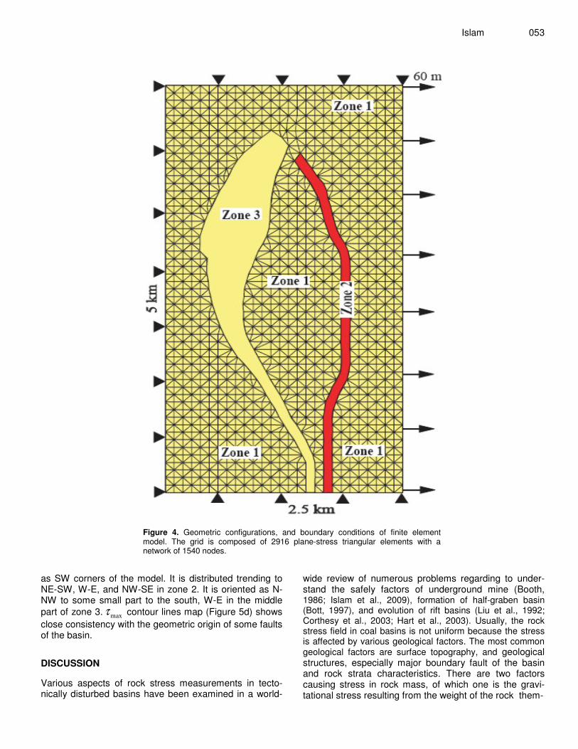
Two-steps of study have been considered by using the aforesaid materials. At the first step, the basin geometry, presented by Wardell Armstrong (1991) and Bakr et al. (1996) is simplified. Then the study is focused on the identification of the main geometric and elastic rock phy-sical properties controlling the deformation in the basin by a numerical model. In the second step, concentration was made to calculate the results, in particular the orientation of maximum horizontal tensional stress, strain distri-bution, displacement vector, and maximum shear stress. A thin-shale type model that incorporates faults, elastic rock properties, and horizontal nodal displacement boun-dary conditions have been used to investigate the distri-bution, orientations, and magnitude of horizontal ten-sional stress. Model geometry The Barapukuria coal basin is a N-S-trending structure and is characterized by a series of faults. The present geometry of the model is composed of 2916 plane-stress triangular elements with a network of 1540 nodes (Figure 4) with a length of about 5 and 2.5 km in width. The assumed thickness of the model rock strata is about 650 m. Rock mechanical properties The entire basin area is divided into three zones: Zone 1, 2 and 3 based on local geotectonic and rock physical
Islam 051
Figure 2. Structural pattern of the Barapukuria coal basin, Dinajpur, Bangladesh (modified after Wardell Armstrong, 1991; Bakr et al., 1996; Islam and Hayashi, 2008a; Islam et al., 2009).
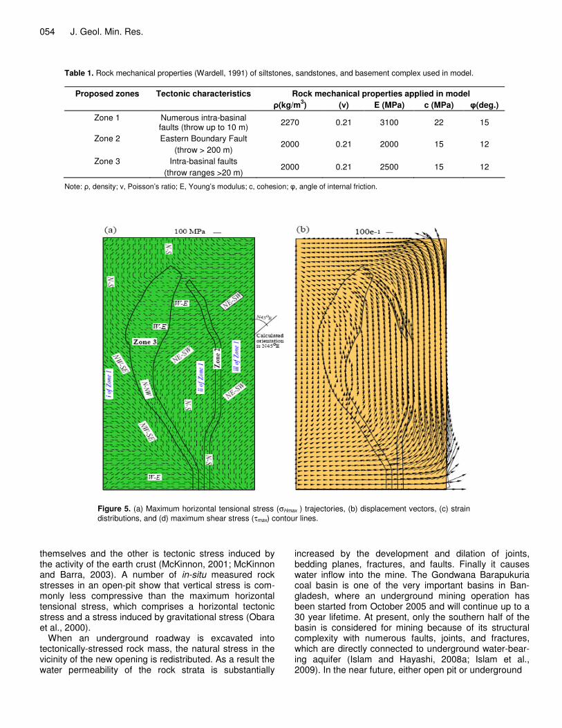
characteristics. In a general sense, fault-affected zone always show less competent with weak rock physical pro-perties. In contrast, a rigid block/zone shows more com-petent and mechanically strong rock physical character-ristics than a fault-affected zone. Therefore, the fault plane of Fa is filled by very weak slickenside materials that reduce the shear strength through fault plane (Islam and Islam, 2005). Five major litho-mechanical properties such as density, Poisson’s ratio, Young’s modulus, friction angle and cohesion for granodiorite, granite and sandstone used in experiment are listed in Table 1. Young’s modulus of E = 2000 to 3100 MPa and Poisson’s ratio n = 0.21,
which is consistent with average elastic properties for crustal rocks of Barapukuria basin (Wardell Armstrong, 1991).
Boundary conditions
In plane-stress finite element modeling, the horizontal no-dal displacement is directly related with tectonic displace-ment or strain. In the Barapukuria basin, the throw of eastern boundary fault is approximately 200 m with a dip 73o, which produces a horizontal displacement of about 61 m (Figure 3d). As a consequence, 60 m horizontal no-
052 J. Geol. Min. Res.
Figure 3. (a) and (b). show schematic views of half-graben basin architecture (after Gibson et al., 1989; Morley, 1999). (c) Cross-sectional view (see location in Figure 2 AA/) of the Barapukuria basin. (d) Explanations to show how 60 m horizontal nodal displacement boundary conditions were assumed of the model. In the case of eastern boundary fault of the Barapukuria basin, throw = 200 m with 73o angle. Calculated horizontal displacement (H.D) = 61 m (after Islam et al., 2009).
nodal displacement was used at the right hand side in modeling. It was assumed that the first failure occurred along the extending elastic layer of the eastern boundary fault (Fa) plane then after completion of 60 m horizontal displacement it led the development of a half-graben type basin. This assumption is reflected in the boundary condition used. The grid and applied boundary conditions are shown in Figure 4. North, west, and south boundaries are fixed, while horizontal nodal displacement 60 m is imposed along the east boundary of the model. Model results
The calculated orientation and magnitude ofσ H max , the dis-
placement vector, the strain distribution, and the τ max contour lines in the model are shown in Figure 5. The orientation of σ H max trajectories is almost NE-SW in most of the part of the zone 1, but it shows some N-S to the northwest part and W-E to southwest part (Figure 5a). In zone 2, the orientation is NW-SE to the south, but it is NE-SW to the north. In zone 3, σ H max is oriented as N-S, NE-SW, and W-E, to the south, middle and north part of the model, respectively. The displacement vector is highly bent to the SE and NE corners of zones 1 and 2 (Figure 5b). But within zone 3, it is not so effective, although the overall displacement vector shows close consistency with the geometry of the basin. In zone 1, the strain orientation (Figure 5c) is very high to the middle, and NE as well as
Islam 053
Figure 4. Geometric configurations, and boundary conditions of finite element model. The grid is composed of 2916 plane-stress triangular elements with a network of 1540 nodes.
as SW corners of the model. It is distributed trending to NE-SW, W-E, and NW-SE in zone 2. It is oriented as N-NW to some small part to the south, W-E in the middle part of zone 3. τ max contour lines map (Figure 5d) shows close consistency with the geometric origin of some faults of the basin. DISCUSSION Various aspects of rock stress measurements in tecto-nically disturbed basins have been examined in a world-
wide review of numerous problems regarding to under-stand the safely factors of underground mine (Booth, 1986; Islam et al., 2009), formation of half-graben basin (Bott, 1997), and evolution of rift basins (Liu et al., 1992; Corthesy et al., 2003; Hart et al., 2003). Usually, the rock stress field in coal basins is not uniform because the stress is affected by various geological factors. The most common geological factors are surface topography, and geological structures, especially major boundary fault of the basin and rock strata characteristics. There are two factors causing stress in rock mass, of which one is the gravi-tational stress resulting from the weight of the rock them-
054 J. Geol. Min. Res.
Table 1. Rock mechanical properties (Wardell, 1991) of siltstones, sandstones, and basement complex used in model.
Rock mechanical properties applied in model Proposed zones Tectonic characteristics �(kg/m3) (�) E (MPa) c (MPa) �(deg.)
Zone 1 Numerous intra-basinal faults (throw up to 10 m) 2270 0.21 3100 22 15
Zone 2 Eastern Boundary Fault (throw > 200 m)
2000 0.21 2000 15 12
Zone 3 Intra-basinal faults (throw ranges >20 m)
2000 0.21 2500 15 12
Note: �, density; �, Poisson’s ratio; E, Young’s modulus; c, cohesion; �, angle of internal friction.
Figure 5. (a) Maximum horizontal tensional stress (σHmax ) trajectories, (b) displacement vectors, (c) strain distributions, and (d) maximum shear stress (τmax) contour lines.
themselves and the other is tectonic stress induced by the activity of the earth crust (McKinnon, 2001; McKinnon and Barra, 2003). A number of in-situ measured rock stresses in an open-pit show that vertical stress is com-monly less compressive than the maximum horizontal tensional stress, which comprises a horizontal tectonic stress and a stress induced by gravitational stress (Obara et al., 2000).
When an underground roadway is excavated into tectonically-stressed rock mass, the natural stress in the vicinity of the new opening is redistributed. As a result the water permeability of the rock strata is substantially
increased by the development and dilation of joints, bedding planes, fractures, and faults. Finally it causes water inflow into the mine. The Gondwana Barapukuria coal basin is one of the very important basins in Ban-gladesh, where an underground mining operation has been started from October 2005 and will continue up to a 30 year lifetime. At present, only the southern half of the basin is considered for mining because of its structural complexity with numerous faults, joints, and fractures, which are directly connected to underground water-bear-ing aquifer (Islam and Hayashi, 2008a; Islam et al., 2009). In the near future, either open pit or underground
Islam 055
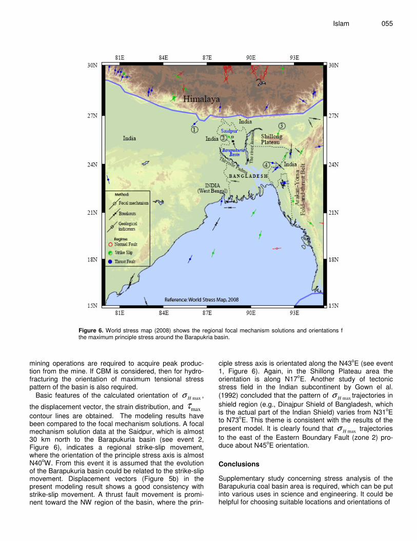
Figure 6. World stress map (2008) shows the regional focal mechanism solutions and orientations f the maximum principle stress around the Barapukria basin.
mining operations are required to acquire peak produc-tion from the mine. If CBM is considered, then for hydro-fracturing the orientation of maximum tensional stress pattern of the basin is also required.
Basic features of the calculated orientation of σ H max ,
the displacement vector, the strain distribution, and τmax contour lines are obtained. The modeling results have been compared to the focal mechanism solutions. A focal mechanism solution data at the Saidpur, which is almost 30 km north to the Barapukuria basin (see event 2, Figure 6), indicates a regional strike-slip movement, where the orientation of the principle stress axis is almost N40oW. From this event it is assumed that the evolution of the Barapukuria basin could be related to the strike-slip movement. Displacement vectors (Figure 5b) in the present modeling result shows a good consistency with strike-slip movement. A thrust fault movement is promi-nent toward the NW region of the basin, where the prin-
ciple stress axis is orientated along the N43oE (see event 1, Figure 6). Again, in the Shillong Plateau area the orientation is along N17oE. Another study of tectonic stress field in the Indian subcontinent by Gown el al. (1992) concluded that the pattern of σ H max trajectories in shield region (e.g., Dinajpur Shield of Bangladesh, which is the actual part of the Indian Shield) varies from N31oE to N73oE. This theme is consistent with the results of the present model. It is clearly found that σ H max trajectories to the east of the Eastern Boundary Fault (zone 2) pro-duce about N45oE orientation. Conclusions Supplementary study concerning stress analysis of the Barapukuria coal basin area is required, which can be put into various uses in science and engineering. It could be helpful for choosing suitable locations and orientations of
056 J. Geol. Min. Res. tunnels, optimal shapes and sizes of the underground openings. Within the context of the assumptions of the present modeling as well as discussed above, main con-clusions of the study are as follows: • It is observed that the four parameters are reasonable in understanding the geometric pattern of the basin. Orientation of σ H max and strain distribution within zones 2 and 3 show a very good agreement with the geometry of faults development. • Although stress within fault zone 1 is spatially variable, the generalized orientation of σ H max trajectories within zone 1 (Figure 5a) show close consistency with the re-sults of regional stress field. • The displacement vector is rotated anticlockwise with respect to the applied boundary condition. This rotation coincides with the intracratonic rift basin developed within the Indian sub-continental crust under stretching environ-ment. • From this finding, it is assumed that the major faults in a coal basin may be rotated with respect to the regional stress field. Pattern of τmax contour lines also show a good consistency with the trend of eastern boundary fault. ACKNOWLEDGEMENTS The author would like to acknowledge the Ministry of Education, Culture, Sports, Science and Technology (Monbukagakusho) of Japan for their financial support. He wishes to thank the Editor-in-Chief, Prof. Dr. Ashraf M.T. Elewa, one anonymous reviewer, and Emeje Cyn-thia, the editorial assistant, for their helpful suggestions and communications on the manuscript. REFERENCES Alam M, Alam MM, Curray J, Chowdhury RMLR, Gani MR (2003). An
overview of the sedimentary geology of the Bengal Basin in relation to the regional tectonic framework and basin-fill history. Sediment. Geol. 155: 179-208.
Bakr MA, Rahman QMA, Islam MM, Islam MK, Uddin MN, Resan SA, Haider MJ, Islam MS, Ali MW, Choudhury MEA, Mannan KM, Anam ANMH (1996). Geology and Coal Deposits of Barapukuria Basin,
Dinajpur District, Bangladesh, Records of Geological Survey of Bangladesh. 8, pt 1.
Booth CJ (1986). Strata-movement concepts and the hydrogeological impact of underground coal mining. Ground Water 24: 507-515.
Bott HPR (1997). Modeling the formation of a half-graben using realistic upper crustal rheology. J. Geophys. Res. 102: 24605-24617.
Buck R (1991). Modes of continental lithosphere extension. J. Geophys. Res. 96: 20161-20178.
Cloetingh S, van Wees JD, van der Beek PA, Spadini G (1995). Role of re-rift rheology in kinematics of extensional basin formation: constraints from thermomechanical models of Mediterranean and intracratonic basins. Marine and Petrol. Geol. 12: 793-807.
Contreras J, Scholz CH, King GCP (1997). A general model of rift basin evolution: constraints of first order stratigraphic observations. J. Geophys. Res. 102: 7673-7690.
Corthesy R, Leite ML, Gill DE, Gaudin B (2003). Stress measurements in soft rocks. Eng. Geol. 69: 381-397.
Gibson JR, CoWalsh JJ, Watterson J (1989). Modeling of bed contours
and cross-sections adjacent to planar normal faults. J. of Struct. Geol. 11: 317-328.
Gown TN, Rao SVS, Gaur VK (1992). Tectonic stress field in the Indian Subcontinent. J. of Geophys. Res. 97: 11879-11888.
Hart R (2003). Enhancing rock stress understanding through numerical analysis. Int. J. of Rock Mech. & Mining Sci. 40: 1089-1097.
Hayashi D (2008). Theoretical basis of FE simulation software pakage. Bull. Fac. Sci. Univ. Ryukyus 85: 81-95.
Islam MR (2005). Influence of tectonic structures for the occurrence of gas emission at 1110 working panel in Barapukuria Coal Mine, Bangladesh. Geodynamics and Environment in East Asia (GEEA), International Conference & 5th Taiwan-France Earth Science Symposium, 24-29 November, 2005, Taitung, Taiwan, pp.155-156.
Islam MR (2009). Origin of the regional stress field along the Liquine-Ofqui Fault Zone (LOFZ), Southern Chilean Andes: by means of FE Simulation. J. of Mountain Sci. 6: 1-13.
Islam MR, Hayashi D (2007). FEM simulation of fold-and-thrust belts in the Southern Central High Andes of Chile and Argentina. Bull. Fac. Sci. Univ. Ryukyus 83, 29-60.
Islam MR, Hayashi D (2008a). Geology and coal bed methane resource potential of the Gondwana Barapukuria Coal Basin, Dinajpur, Bangladesh. Int. J. of Coal Geol. 75: 127-143.
Islam MR, Hayashi D (2008b). Extensional stresses in the fold-and-thrust belt of the Southernmost Andes. Bullettino di Geofisica Teorica ed Applicata 49: 223-228.
Islam MR, Hayashi D (2009). Extensional stresses in the Colombian Eastern Cordillera fold-and-thrust belt, northern Andes: insights from 2D Finite Element Modeling. Geologica Acta 7: 333-350.
Islam MR, Hayashi D, Kamruzzaman ABM (2009). Finite element modeling of stress distributions and problems for multi-slice longwall mining in Bangladesh, with special reference to the Barapukuria coal mine. Int. J. Coal Geol. 78: 91-109.
Islam MR, Shinjo R (2009). Numerical simulation of stress distributions and displacements around an entry roadway with igneous intrusion and potential sources of seam gas emission of the Barapukuria coal mine, NW Bangladesh. Int. J. Coal Geol. 78: 249-262.
Islam MR, Islam MS (2005). Water Inrush Hazard in Barapukuria Coal Mine, Bangladesh. Bangladesh J. of Geol. 24, 1-17.
Islam MR, Kamruzzaman ABM (2006). Geochemical and Techno-environmental Behaviour of Gondwana Coals from the Barapukuria coal mine, Bangladesh. Bangladesh J. Geol. 25: 48-63.
Khan AA, Chouhan RKS (1996). The crustal dynamics and the tectonic trends in the Bengal Basin. J. Geodynamics 22: 267-286.
Khan FH (1991). Geology of Bangladesh, pp 33-40, Willey Eastern Limited, 4835/24 Ansari Road, Daryaganj, New Delhi 110002, India.
Liu L, Zoback MD (1992). The effect of topography on the state of stress in the crust: Application to the site of the Cajon Pass Scientific Drilling. J. Geophys. Res. 97: 5095-5108.
McKinnon SD (2001). Analysis of stress measurements using a numerical model methodology. Int. Journal of Rock Mech. & Mining Sci. 38: 699-709.
McKinnon SD, Barra IG, (2003). Stress field analysis at the El Teniente Mine: evidence for N-S compression in the modern Andes. J. of Struct. Geol. 25: 2125-2139.
Morley CH (1999). Pattern of displacement along large normal faults: Implications for basin evolution and fault propagation, based on examples from east Africa. AAPG Bulletin 83: 613-634.
Obara Y, Nakamura N, Kang SS, Kaneko k (2000). Measurement of local stress and estimation of regional stress associated with stability assessment of an open-pit rock slope. Int. J. Rock Mech. & Mining Sci. 37: 1211-1221.
Wardell Armstrong (1991). Techno-Economic Feasibility Study of Barapukuria Coal Project (unpubl.), Dinajpur, Bangladesh.


![Introduction - University of Pittsburgh · events from PDF ensemble, via REA method, on Senegal River Basin, Hydrology and Earth System Sciences, 15 (2011), 3605-3615. [13] M.D. Gunzburger,](https://static.fdocument.org/doc/165x107/5eb7bbd9c5e420359f1c3800/introduction-university-of-events-from-pdf-ensemble-via-rea-method-on-senegal.jpg)