ηλεια
55
ηλεια ilia ημεγαληταξιδιωτικηεμπειρια Thegreatesttravelexperience Περιηγητικοσοδηγοσηλειασ touristguideofIlia «Το έντυπο αυτό χρηματοδοτήθηκε από την Κ.Π. LEADER+ με ποσοστό χρηματοδότησης 70% (52,50% ΕΓΤΠΕ + 17,50% Εθνική συμμετοχή)» ΥΠΟΥΡΓΕΙΟ ΑΓΡΟΤΙΚΗΣ ΑΝΑΠΤΥΞΗΣ & ΤΡΟΦΙΜΩΝ ΕΥΡΩΠΑΪΚΗ ΕΠΙΤΡΟΠΗ ΑΝΑΠΤΥΞΙΑΚΗ ΟΛΥΜΠΙΑΣ Α.Ε. LEADER+
-
Upload
poillie-vassisoali -
Category
Travel
-
view
507 -
download
5
Transcript of ηλεια

ηλεια ilia
η μεγαλη ταξιδιωτικη εμπειρια
The greatest travel experience
Περιηγητικοσ οδηγοσ ηλειασtourist guide of Ilia
«Το έντυπο αυτό χρηματοδοτήθηκε από την Κ.Π. LEADER+ με ποσοστό χρηματοδότησης 70% (52,50% ΕΓΤΠΕ + 17,50% Εθνική συμμετοχή)»
ΥΠΟΥΡΓΕΙΟ ΑΓΡΟΤΙΚΗΣ ΑΝΑΠΤΥΞΗΣ & ΤΡΟΦΙΜΩΝ
ΕΥΡΩΠΑΪΚΗ ΕΠΙΤΡΟΠΗ ΑΝΑΠΤΥΞΙΑΚΗ ΟΛΥΜΠΙΑΣ Α.Ε. LEADER+

Ανακαλύπτοντας την Ηλεία
περιηγητικός οδηγός νομού Ηλείαςtravel guide for ilia region
discovering Ilia
1

Η Ηλεία απολαμβάνει την καλή τύχη να είναι ο τόπος που συνδέθηκε με τις κορυφαίες στιγμές του Ελληνικού Πολιτι-σμού ως χώρος γέννησης και διεξαγωγής των αρχαίων Ολυμπιακών Αγώνων. Ταυτόχρονα, όμως, έχει το προνόμιο να αποτελεί μια μικρογραφία της ομορφότερης χώρας του κόσμου, της Ελλάδας.
Απέραντες χρυσές αμμουδιές εναλλάσσονται με κατα-πράσινα τοπία και δάση. Σπάνιοι υδροβιότοποι συμπληρώνουν ονειρεμένες διαδρο-μές ποταμών. Περισσότερη ηλιοφάνεια και μοναδικές γεύσεις που δίνουν ξεχωριστό χρώμα και απόλαυση στις διακοπές. Πολιτιστικοί θεσμοί και μνημεία της παγκόσμιας κληρονομιάς και, πάνω απ’ όλα, εύκολη πρόσβαση, ασφάλεια και δυναμική τοπική οικονομία που επιτρέπουν ξέγνοιαστες διακοπές σε όλους.
Απολαύστε το ταξίδι στην Ηλεία. Στον τόπο όπου καθένας νιώθει σαν το σπίτι του.
Γιάννης Λυμπέρης Πρόεδρος Τ.Ε.Δ.Κ. Ν. Ηλείας
The county of Ilia has been privileged enough to be connected to the greatest mo-ments of the Hellenic Culture, since Ilia is the place that gave birth and held the Ancient Olympic Games. Additionally, we could claim that the region of Ilia is a scaled - down model of the world’s most beautiful country, Hellas.
Endless golden beaches hand their beauty to green landscapes and forests. Rivers flow through unique wetlands composing paths that man could only dream of. There is more in the sunlight and the special flavors that make vacations in Ilia even brighter and worth enjoying. The Cultural Facts and the Monuments that represent our heritage to the world and, above all, the convenient access, the sense of security, as well as the dynamic local economy, offer the chance to everyone to have a great and carefree holiday.
Yiannis Lyberis President of T.E.d.k. of Ilia
καλωσ ηλθατε
welcome
2

ContentsΚαλώς ήλθατε στην Hλεία 6
Δήμος Αλιφείρας 8
Δήμος Αμαλιάδας 10
Δήμος Ανδραβίδας 12
Δήμος Ανδρίτσαινας 14
Δήμος Αρχαίας Ολυμπίας 16
Δήμος Βαρθολομιού 18
Δήμος Βουπρασίας 20
Δήμος Βώλακος 22
Δήμος Γαστούνης 24
Δήμος Ζαχάρως 26
Δήμος Ιάρδανου 28
Δήμος Κάστρου Κυλλήνης 30
Δήμος Λαμπείας 32
Δήμος Λασιώνος 34
Δήμος Λεχαινών 36
Δήμος Πηνείας 38
Δήμος Πύργου 40
Δήμος Σκιλλούντος 42
Δήμος Τραγανού 44
Δήμος Φιγαλείας 46
Δήμος Φολόης 48
Δήμος Ωλένης 50
Τρεις ματιές από ψηλά 53
Ηλεία 776 π.χ. - 2009 μ.χ.
Ένα μοναδικό ταξίδι στο χρόνο,
στην ιστορία και τον πολιτισμό 55
Αρχαία Ολυμπία 56
Αρχαία Ήλιδα 64
Επικούρειος Απόλλων 68
Αρχαία Φιγαλεία 70
Αρχαία Αλιφείρα 71
Αρχαία Σκιλλουντία 73
Aρχαιολογικοί χώροι - Μνημεία 76
Η φύση της Ηλείας 80
Λίμνη Καϊάφα 82
Νέδα 84
Δρυοδάσος Φολόης 86
Λιμνοθάλασσα Κοτυχίου 88
Λίμνη Πηνειού 90
Hλεία - Η γη του πράσινου 92
Ηλεία - Χώρος Ζωής 94
Ο σεβασμός στη φύση
είναι δείκτης πολιτισμού 96
Welcome to the county of Ilia 6
Municipality of Alifeira 8
Municipality of Amaliada 10
Municipality of Andravida 12
Municipality of Andritsaina 14
Municipality of Ancient Olympia 16
Municipality of Vartholomio 18
Municipality of Vouprasia 20
Municipality of Volakos 22
Municipality of Gastouni 24
Municipality of Zacharo 26
Municipality of Iardanos 28
Municipality of kastro – kyllini 30
Municipality of Lampeia 32
Municipality of Lasion 34
Municipality of Lexaina 36
Municipality of Pineia 38
Municipality of Pyrgos 40
Municipality of Skillounta 42
Municipality of Tragano 44
Municipality of Figaleia 46
Municipality of Foloi 48
Municipality of Oleni 50
Three overviews from Ilia 54
Ilia 776 d.C. - 2009 a.c.
Α unique trip into time, history
and culture 55
Ancient Olympia 56
The Ancient Elis 64
Apollo Epikourios 68
Ancient Figaleia 70
Ancient Alifeira 72
Ancient Skilountia 74
Archeological sites - Historical
monuments 78
The nature of Ilia 80
The Lake of kaiafas 82
River Neda 84
The oak forest of Foloi 86
The lagoon of kotychi 88
Lake of Peneios 90
Ilia - The green land 93
Ilia - The land of life 94
The respect for nature indicates the
Περιεχομενα
3

Contentscivilization groth 97
Τrips in Ιlia 98
Ilia and Sea 146
Ports of the prefecture Ilia 160
The monasteries in Ilia 164
Sports and Nature 176
Cultural Events
in the Prefecture of Ilia 186
Restaurants - Taverns
of the Prefecture of Ilia 196
Hotels of the Prefecture of Ilia 204
Furnished Apartments
Rooms to Let in Prefecture of Ilia 221
Camping sites
of the Prefecture of Ilia 224
Convention Centers
of the Prefecture of Ilia 225
Travel Agencies
of the Prefecture of Ilia 227
Useful Telephone Numbers
of the Prefecture of Ilia 228
ΠεριεχομεναΗλειακές διαδρομές 98
Hλεία και θάλασσα 146
Λιμάνια της Ηλείας 160
Τα μοναστήρια της Ηλείας 164
Σπορ στη φύση 176
Hλεία & Πολιτισμός 186
Ηλειακή φιλοξενία
Εστιατόρια – Ταβέρνες
Νoμού Ηλείας 196
Ξενοδοχεία Ν. Ηλείας 204
Επιπλωμένα Διαμερίσματα –
Ενοικιαζόμενα Δωμάτια
Νομού Ηλείας 221
Camping Ν. Ηλείας 224
Συνέδρια στην Ηλεία 225
Τουριστικά γραφεία Ν. Ηλείας 227
Χρήσιμα τηλέφωνα Ν. Ηλείας 228
ΚατάκολοKatakolo
4

Ακολουθώνταςτην ομορφιά της Ελλάδας
Following the beauty of Greece
Ανακαλύπτειςτην
Πελοπόννησο
Discovering Peloponnese
Kαι καταλήγεις στην Ηλεία
ArrivingIlia 5

Σε ένα στρατηγικό σημείο της Μεσογεί-ου, στη Δυτική Ελλάδα, η Ηλεία αποτελεί πύλη προς τα Επτάνησα και κόμβο που ενώνει, από τα αρχαία χρόνια, πολιτισμούς και παραδόσεις.
Διοικητικά, η Ηλεία ανήκει στην Περιφέ-ρεια Δυτικής Ελλάδας και έχει έκταση 2.618 τετραγωνικά χιλιόμετρα. Οι μόνιμοι κάτοικοί της ξεπερνούν τους 180.000, ενώ το καλοκαίρι πολλές δεκάδες χιλιάδων επισκεπτών επιλέγουν να περνούν τις δι-ακοπές τους εδώ, αξιοποιώντας την εύκο-λη χερσαία πρόσβαση, την πλήρως οργα-νωμένη τοπική οικονομία που επιτρέπει με τις υποδομές της ακόμη και το συνδυα-
Ilia lies in a strategic point of the Medi-terranean Sea, in the Western part of Hel-las, and is considered to be the gateway to Eptanisa (Ionian Sea) and the place where different cultures and traditions meet for centuries.
The county of Ilia belongs to the Western District of Hellas and covers an area of 2.618 square kilometers. Its population is estimated to be more than 180.000 perma-nent inhabitants, while during the summer time many dozens of thousands of visitors choose to spend their holidays in Ilia, tak-ing advantage of the convenient access
καλωσ ηλθατε στην ηλεια Welcome to the countRy of Ilia
6

σμό διακοπών και εργασίας, αλλά και τις πλήρεις υποδομές υγείας που δίνουν σι-γουριά σε οικογένειες και μεμονωμένους επισκέπτες κάθε ηλικίας.
Η Ηλεία συνορεύει στα Βόρεια με την Αχαΐα, στα Νότια με τη Μεσσηνία, στα Ανα-τολικά με την Αρκαδία και στα Δυτικά με τα Επτάνησα. Έτσι, όποιος την επιλέγει για τις διακοπές του, μπορεί να πραγματοποιεί εύκολα αποδράσεις σε όλες αυτές τις γει-τονικές περιοχές.
Πρωτεύουσα του νομού είναι ο Πύργος με 35.000 κατοίκους και δεύτερη μεγαλύ-τερη πόλη η Αμαλιάδα με πληθυσμό 30.000.
Οι 22 δήμοι που απαρτίζουν την Ηλεία είναι οι δήμοι Αλιφείρας, Αμαλιάδας, Αν-
δραβίδας, Ανδρίτσαινας, Αρχαίας Ολυμπί-ας, Βαρθολομιού, Βουπρασίας, Βώλακος, Γαστούνης, Ζαχάρως, Ιάρδανου, Κάστρου-Κυλλήνης, Λαμπείας, Λασιώνος, Λεχαινών, Πηνείας, Πύργου, Σκιλλούντος, Τραγανού, Φιγαλείας, Φολόης και Ωλένης.
Στην Ηλεία βρίσκεται και η μεγαλύτερη πεδιάδα της Πελοποννήσου, ενώ η υψη-λότερη κορυφή του νομού είναι η Λάμπεια (1.797 μέτρα) και ακολουθούν η Φολόη, ο Λαπίθας και η Μίνθη.
Δύο ποταμοί, ο Αλφειός και ο Πηνειός, οι οποίοι συνδέονται με σημαντικούς δε-σμούς με την Ελληνική Μυθολογία, δια-τρέχουν το νομό και χαρίζουν ευφορία στη γη και απεριόριστες ευκαιρίες αναψυχής στους επισκέπτες.
through the national road network, the fully organized local economy that offers the necessary standards which even allow a combination of holidays and labor, but also the excellent health infrastructure that offer the sense of safety to families, as well as to single visitors of any age.
Ilia neighbors to the North with Achaia, to the South with Messinia, to the East with Arcadia and to the West with Eptanisa. Thus, anyone who chooses to spend his holiday in Ilia, may also visit quite easily all these areas.
The capital of the peripheral of Ilia is Pyr-gos (population 35.000) while the second larger city is Amaliada (population:
30.000). Ilia consists of 22 municipalities: Alifeira,
Amaliada, Andravida, Andritsaina, Ancient Olympia, Vartholomio, Vouprasia, Volakas, Gastouni, Zacharo, Iardanos, Kastro-Kyllini, Lampeia, Lasiona, Lechaina, Pineia, Pyrgos, Skillounta, Tragano, Figaleia, Foloi and Oleni.
The biggest valley of Peloponnese lies in Ilia, while the highest peak in the peripheral is Lampeia (1797m). Foloi, Lapithas and Minthi come next.
Alfeios and Pineios, these two rivers that are bonded tightly to the Greek Mythology, go through the peripheral of Ilia making the land fertile, offering the visitors mo-ments of amusement. 7

Δημοσ Αλιφειρασ Municipality of AlifeiraΜε έδρα την Καλλιθέα, ο Δήμος Αλιφεί-
ρας έχει πληθυσμό 3.829 κατοίκους και έκταση 110000 στρέμματα.
Χαρακτηριστικός ορεινός δήμος της Ηλείας η Αλιφείρα, διαθέτει πλούσιο δασι-κό περιβάλλον και οι κύριες καλλιέργειές του είναι η ελιά και τα αμπέλια, ενώ διαθέ-τει εξαιρετικά ανεπτυγμένη κτηνοτροφία.
Λόγω της μεγάλης έκτασης και των ιδι-αίτερων χαρακτηριστικών της τοπικής οι-κονομίας υπάρχουν πολλοί οικισμοί, αρ-κετοί από του οποίους έχουν σημαντικά παραδοσιακά αρχιτεκτονικά στοιχεία. Οι οικισμοί αυτοί είναι Καλλιθέα, Αλιφείρα, Αμυγδαλιές, Βρεστό, Λιβαδάκι, Μυρώνια, Μπαρακίτικα, Πευκίο, Κάτω Αμυγδαλιές, Αγ. Ηλίας, Κεραμίδι, Κράνα, Παλαιοχώρι, Λογγό, Πτελέα, Ράπτη, Αγ. Βλάσης, Κλήμα και Ράμα.
Ο επισκέπτης έχει την ευκαιρία να επι-σκεφθεί ένα πλήθος αξιοθέατων όπως ο Ναός της Αθηνάς στην αρχαία Αλιφείρα, το Φαράγγι του Τρίτωνα στις Αμυγδαλιές και στην Αλιφείρα, ο αρχαιολογικός χώρος Βρεστού στη θέση «Γαρδίκι», το δάσος Τα-χοβουνίου στην Καλλιθέα και στο Λιβαδά-κι, η Ιερά Μονή Σεπετού στην Αλιφείρα, το πετρογέφυρο Μακαρουνάς και η πηγή «Στρίγγλα» στο Λιβαδάκι, το πετρογέφυ-ρο Τσεμπερούλας στον οικισμό Μπαρακί-τικων και οι παραδοσιακοί νερόμυλοι στα Μυρώνια και στις Αμυγδαλιές.
Kallithea, the seat of the municipality of Alifeira, has a population of 3.829 inhabit-ants and extends to 110.000 square me-ters.
Alifeira is a typical mountainous periph-eral of Ileia with a strongly forestal envi-ronment, where olives and vineyards are cultivated, while at the same time animal husbandry is widely developed.
Due to the great extension of the land and to the special characteristics of the lo-cal economy there are many housing es-tates, most of which maintain their tradi-tional architecture. These housing estates are: Kallithea, Alifeira, Amygdalies, Vresto, Livadaki, Myronia, Mparakitika, Pefkio, Kato Amygdalies, Ag.Elias, Keramidi, Kra-na, Palaiochori, Loggo, Ptelea, Rapti, Ag.Vlassis, Klima and Rama.
Visitors have the chance to visit numer-ous places of great interest, such as the Temple of Athena in ancient Alifeira, the Triton Canyon in Amygdalies and Alifeira, the archaeological site of Vresto in Gardiki, the Tachovouni forest in Kallithea and in Livadaki, the Holy Temple of Sepetos in Alifeira, the stone bridge Makarouna and the spring “Striggla” in Livadaki, the stone bridge Tsemperoulas in the housing estate called Mparakitika, as well as the tradition-al water-mills in Myronia and in Amyg-dalies.
Kαταρράκτες ΤρίτωναTritona waterfalls
8

Ιερά Μονή ΣεπετούIera Moni Sepetou (Holy Monastery of Sepetou)
9

Δημοσ Αμαλιαδασ Municipality of AmaliadaΟ δήμος Αμαλιάδας περιλαμβάνει την
πόλη της Αμαλιάδας και 19 πρώην κοινό-τητες. Είναι ο πρώτος σε έκταση (256.988 στρέμματα) και ο δεύτερος σε πληθυσμό (32.090) δήμος του νομού Ηλείας.
Η Αμαλιάδα, έδρα του δήμου, είναι μια σύγχρονη και δυναμική πόλη που βρέχε-ται από το Ιόνιο Πέλαγος προς τα δυτικά και από τη Λίμνη του Πηνειού προς τα ανα-τολικά.
Απέχει 294 χλμ. από τον Πύργο, 42 χλμ. από την Αρχαία Ολυμπία και 140 χλμ. από την Καλαμάτα.
Πολιτιστικό Κέντρο του Δήμου Αμαλιά-δας είναι η Αρχαία Ήλιδα, η διοργανώτρια πόλη των Αρχαίων Ολυμπιακών Αγώνων. Αποτελεί άριστο ορμητήριο προς τα Ιόνια Νησιά καθώς απέχει μόνο 31 χλμ. από το λιμάνι της Κυλλήνης.
Διαθέτει οργανωμένο νοσοκομείο, σχο-λές τριτοβάθμιας εκπαίδευσης και άριστες υποδομές φιλοξενίας. Το αλιευτικό λιμάνι στο Παλούκι και η διάσημη παραλία της Κουρούτας είναι το φυσικό κέντρο διακο-πών της περιοχής.
The municipality of Amaliada includes the city of Amaliada and 19 other villages. Amaliada is the biggest municipality with an area of 256.988 sq.km and the second in numbers of population (32.090), in the pe-ripheral of Ilia.
Amaliada, the seat of the municipality, is a modern and dynamic city, with the Ionian Sea embracing the west coast and the Lake of Pineios River the east.
It’s 294km far from Pyrgos, 42km from the Ancient Olympia and 140km from Ka-lamata city.
The Cultural Station of the municipality of Amaliada is Ancient Ilida, the place where the Ancient Olympic Games are being or-ganized. This is the best place for you to set your course to the Ionian Islands as it is only 31km far from the port of Kyllini.
There are organized health facilities (hospital), schools of higher education (col-leges) as well as top-class lodging infra-structure. The fishing port in Palouki and the well known beach of Kourouta are the spots where you can enjoy natural vaca-tion.
Λιμάνι ΠαλουκίουPalouki Port
10

Παραλία Κουρούτας
Κοurouta Beach
11

Δημοσ ΑνδραβιδαΣ Municipality of AndravidaΗ Ανδραβίδα είναι μία σύγχρονη πόλη
με πληθυσμό 4.400 κατοίκων ο οποίος βαίνει συνεχώς αυξανόμενος. Βρίσκεται δίπλα στον Εθνικό Οδικό Άξονα Αθήνα – Πύργος, και διαθέτει σταθμό του σιδηρο-δρομικού δικτύου που συνδέει την Αθήνα με την Καλαμάτα. Σε απόσταση 2,5 χιλιο-μέτρων από την πόλη βρίσκεται το στρατι-ωτικό αεροδρόμιο και η βάση. Αποτελεί το κέντρο της περιοχής και περιβάλλεται σε ακτίνα λίγων χιλιομέτρων από χωριά και κωμοπόλεις όπως Βάρδα, Λεχαινά, Στρού-σι, Μυρσίνη, Τραγανό, Καβάσιλα, Σταφιδό-καμπος, Γαστούνη. Στο κέντρο της πόλης βρίσκεται σημαντικό τμήμα του Ναού της Αγίας Σοφίας κτίσμα του 13ου αιώνα μονα-δικό τεκμήριο που να θυμίζει στους κατοί-κους και στους επισκέπτες την ιστορία και τον πολιτισμό που αναπτύχθηκε σ’ αυτόν τον τόπο.
Andravida is a modern city with a popu-lation of 4.400 inhabitants which is gradu-ally rising. The city is next to the National Road that connects Athens – Pyrgos, and has its own station in the railway network that connects Athens to the city of Ka-lamata. 2.5km outside Andravida there is a military base and airport. It is considered to be the centre of the greater area and is surrounded in a spread of few kilometers by villages and towns like Varda, Lechaina, Strousi, Myrsini, Tragano, Kavasila, Stafi-dokampos, Gastouni. At the center of the city there is a part of the Temple of Agia Sofia, a building which dates back to the 13th century, and is significant enough to remind the citizens, as well as the visitors, the history and the culture that once was developed in that place.
Ιππική έκθεση ΑνδραβίδαςThe Horse Festival of Andravida
12

Αγία ΣοφίαAgia Sophia church in Andravida
13

Δημοσ ανδριτσαιναΣ Municipality of AndritsainaΗ ιστορική πετρόκτιστη Ανδρίτσαινα,
έδρα μιας από τις πιο φημισμένες βιβλιο-θήκες της Ευρώπης, βρίσκεται στο Νοτιοα-νατολικό άκρο του νομού Ηλείας. Αποτελεί σύνορο με την Αρκαδία και τη Μεσσηνία.
Έχει έκταση 132.000 στρέμματα και πληθυσμό 2.152 κατοίκους. Είναι ορεινή και οι κάτοικοί της είναι στην πλειοψηφία τους γεωργοί και κτηνοτρόφοι.
Φιλοξενεί πολλά εργαστήρια και βιοτε-χνίες, όπως ελαιοτριβεία, παραγωγή ζυμα-ρικών, αρτοποιεία κ.λπ. ενώ διαθέτει ορ-γανωμένες τραπεζικές και υγειονομικές υποδομές.
Η Ανδρίτσαινα αποτελεί μεγάλο αγροτο-τουριστικό κέντρο και απέχει 65 χλμ. από τον Πύργο και 45 χλμ. από την Αρχαία Ολυ-μπία. Γειτονεύει με το μνημείο του Επικού-ρειου Απόλλωνα, ενώ αποτελεί ένα πραγ-ματικό αρχιτεκτονικό διαμάντι, καθώς πολλά από τα σπίτια, τις βρύσες και τα καλ-ντερίμια της είναι ανακηρυγμένα ιστορικά πολιτιστικά μνημεία.
Η Ανδρίτσαινα, γενέτειρα του Φιλικού Παναγιώτη Αναγνωστόπουλου φιλοξενεί μεγάλο Λαογραφικό Μουσείο με 4.000 εκ-θέματα καθώς και την διάσημη Νικολο-πούλειο Βιβλιοθήκη με χιλιάδες σπάνια βιβλία.
The historical stone-built village of An-dritsaina, the seat of one of the most fa-mous libraries in Europe, is at the south-east end of the peripheral of Ilia. Andritsaina is the natural boundary between Arcadia and Messinia.
It has an area of 132.000 square km and its population is of 2.152 inhabitants. It is a mountainous land and most of its inhabit-ants are farmers and stock breeders.
There are many work-shops and small industries, such as oil presses, pastry in-dustries, bakeries, etc. and also there are organized banking and health facilities.
Andritsaina is a major agricultural center and it is located 65km far from Pyrgos and 45km from the Ancient Olympia. It is very close to the Temple of Epicurius Apollo, while it is considered to be a real architec-tural diamond, as most of its houses, foun-tain-heads and cobblestone pavements have been recognized as great historical and cultural monuments.
Andritsaina, the home city of Panagiotis Anagnostopoulos (member of Filiki Eteria), has a magnificent Folkloric Museum with 4.000 exhibits as well as the famous Nikol-opoulios Library with thousands of rare books.
AνδρίτσαιναAndritsaina
14

H “Τρανή Βρύση”The great fountain (Trani Vrysi)
15

ΔΗΜΟΣ ΑΡΧΑΙΑΣ ΟΛΥΜΠΙΑΣΗ Αρχαία Ολυμπία βρίσκεται 19 χιλιόμε-
τρα μακριά από τον Πύργο. Οι Αρχαίοι Έλ-ληνες διάλεξαν για τόπο λατρείας του Δία και τέλεσης των Ολυμπιακών αγώνων μια περιοχή ιδιαιτέρου φυσικού κάλλους, κάτω από τον Κρόνιο λόφο στο σημείο που ο ποταμός Αλφείος δέχεται τα νερά του πα-ραπόταμού του Κλαδέου.
Σήμερα η περιοχή είναι ένας από τους σημαντικότερους αρχαιολογικούς χώ-ρους όλου του κόσμου. Οι επισκέπτες μπορούν να δουν απομεινάρια από τον τεράστιο Ναό του Δία, όπου βρισκόταν το χρυσελεφάντινο άγαλμα του Δία, ένα από τα εφτά θαύματα του κόσμου, το Ηραίο (Ναός της ‘Ηρας), το Βουλευτήριο, όπου οι αθλητές έδιναν τον Ολυμπιακό όρκο, το Φιλιππείον, το Λεονιδαίον που χρησίμευε σαν ξενώνας για σημαντικά πρόσωπα, την παλαίστρα που ήταν προπονητήριο για την πάλη, το παγκράτιο και τα άλματα, το Γυμνάσιο που ήταν το προπονητήριο για τα υπόλοιπα αθλήματα, το Πρυτανείο που ήταν έδρα της ελλανοδίκου επιτρο-πής, το εργαστήριο του Φειδία, τους Θη-σαυρούς των πόλεων και φυσικά το Αρ-χαίο στάδιο μήκους 212,45 μέτρων και χωρητικότητας περίπου 45.000 θεατών.
Municipality of Ancient Olympia
Ancient Olympia is 19km far from Pyr-gos. The Ancient Greeks chose this area of great natural beauty, to worship Zeus and hold the Olympic Games, right at the feet of mount Kronios, at the confluence of the Alpheios and the Kladeos rivers.
Nowadays, this land is considered to be one of the greatest archaeological sites in the world. Visitors are able to admire the remnants of the enormous Temple of Zeus, where the chryselephantine statue of Zeus used to be, one of the Seven Won-ders of the World, the Heraion (Temple of Hera), the Bouleuterion, where the ath-letes gave the Olympic vow, the Philip-peion, the Leonidaion that was used as a hostel for distinguished visitors, the Pal-aestra which was used to practice wres-tling, boxing and jumping, the Gymnasium which was used for training for the rest of the sports, the Prytaneion which was the seat of the magistrate’s committee, the Workshop of Pheidias, the Treasuries of the cities and of course the Ancient stadi-um of 212,45m length and 45.000 seats capacity.
Νίκη του ΠαιωνίουNike of Paionios
Η παράδοση της Ολυμπιακής φλόγας The Olympic Flame-lighting ceremony Patron saint
16

ΦιλιππείοFilipeio
17

δημοσ Βαρθολομιου Municipality of VartholomioΟ Δήμος Βαρθολομιού έχει πληθυσμό
5.348 κατοίκους και έκταση 60.696 στρέμ-ματα. Αποτελείται από 5 δημοτικά διαμερί-σματα και απέχει 280 χλμ. από την Αθήνα, 70 από την Πάτρα, 33 από τον Πύργο και 12 από το λιμάνι της Κυλλήνης.
Βρίσκεται στα Δυτικά του νομού και χαρα-κτηρίζεται από το μεγάλο και εξαιρετικής ποιότητας παράκτιο Λευκοδάσος το οποίο ενώνει την εύφορη πεδιάδα με μια από τις ομορφότερες και μεγαλύτερες ενιαίες αμ-μουδιές της Ελλάδας.
Διαθέτει πολλά ξενοδοχεία και ενοικια-ζόμενα δωμάτια, τόσο στην έδρα του δήμου και στον οικισμό Βρανά, όσο –κυρίως- και στον παραθαλάσσιο οικισμό Αρκούδι, έναν από τους πιο οργανωμένους τουριστικούς προορισμούς της Δυτικής Ελλάδας. Συνολι-κά ο δήμος έχει τέσσερις παραλίες. Τις Θί-νες, το Αρκούδι, τη Γλύφα και την Παραλία Καλυβίων.
Διαθέτει τράπεζες και οργανωμένες υπηρεσίες και εμπόριο.
Ένα από τα σημαντικότερα μνημεία του είναι η μεσαιωνική ιστορική Μονή Παναγί-ας Ελεούσας στη Λυγιά.
The municipality of Vartholomio has a population of 5.348 inhabitants and its land is 60.696 km2. It consists of 5 municipal de-partments and is 280km far from Athens, 70km from Patra, 33km from Pyrgos and 12km from the port of Kyllini.
Vartholomio is located in the West part of the prefecture and one of its most distinct characteristics is the finest coastal Leyko-dasos which joins the fertile valley to one of the greatest and most beautiful sandy beaches of Hellas.
There are many hotels and rooms to let in the center of the municipality as well as in the housing block Vranas, and – mainly – in the housing block Arkoudi which is by the sea, and is one of the most popular and or-ganized tourist destinations of the Western Hellas. There are four beaches in the munici-pality in total. Thines, Arkoudi, Glyfa and the beach Kalyvia.
There are also banks, organized services and merchantry.
One of the most important monuments of Vartholomio is the mediaeval historical Tem-ple of Panagia Eleousa in Lygia.
Μονή Αγίας ΕλεούσαςMonastery of Agia Eleousa
18

Παραλία ΑρκουδίουArkoudi Beach
19

ΔΗΜΟΣ ΒΟΥΠΡΑΣΙΑΣ Municipality of VouprasiaΑνάμεσα στις πιο εύφορες και παραγω-
γικές περιοχές της Πελοποννήσου -και γενικότερα- συγκαταλέγεται η Βουπρα-σία που από το μακρινό παρελθόν παρου-σιάζει σημαντική ιστορία και συμμετοχή στα πιο μεγάλα γεγονότα που σημειώθη-καν κατά το μακρινό παρελθόν.
Το όνομά της η περιοχή το πήρε από την κύρια ασχολία των κατοίκων της που ήταν η ανατροφή και το εμπόριο βοοειδών (βους και πιπράσκειν), κάτι που συμβαί-νει σε σημαντικό ποσοστό και σήμερα.
Ολόκληρη η περιοχή παρουσιάζει τε-ράστιες δυνατότητες ανάπτυξης αφού συνδυάζει την εύφορη κοιλάδα με τα σπάνια οικοσυστήματα, τις απέραντες ακρογιαλιές με τα γραφικά χωριά και τον ιαματικό τουρισμό με την άμεση πρόσβα-ση προς τα μεγάλα αστικά κέντρα.
Vouprasia is ranked among the most fertile and productive lands of Pelopon-nese – and in general – actively present to the greatest historical events that took place in the distant past.
The name of this area was given after the main occupation of its inhabitants which was ox breeding and trading (βους and πιπράσκειν = Βουπρασία), and still is regarding a significant percentage.
The fertile valley and the rare ecosys-tem of the greater area, the endless beaches and the picturesque villages, the therapeutic tourism and the easy access to the big cities, propose great chances of development.
Λιμνοθάλασσα ΚοτυχίουThe lagoon of Kotychi
20

Παραλία ΣτροφυλιάςStofylia Beach
21

δημοσ Βώλακοσ Municipality of VolakosΟ Δήμος Βώλακος έχει πληθυσμό 3.552
κατοίκους και έδρα το Επιτάλιο. Προς Βορ-ρά συνορεύει με τον Πύργο. Το Επιτάλιο βρίσκεται δίπλα στην αποξηραμένη λίμνη της Αγουλινίτσας. Εκεί, σε μικρή απόστα-ση, βρίσκεται μία υπέροχη αμμουδιά, με λίγο κόσμο, ιδανική για τους λάτρεις της φύσης.
Η θέση του αρχαίου Επιταλίου βρίσκεται βορειοδυτικά της σημερινής και η ανα-σκαφή έφερε στο φως ρωμαϊκό λουτρό, εργαστήρια, κεραμικό κλίβανο, μεγάλο δημόσιο κτήριο και πολλά θεμέλια οικι-ών.
Το περιβάλλον είναι το κύριο χαρακτη-ριστικό του δήμου Βώλακος. Στα όριά του εισβάλλει ο Αλφειός και το δέλτα του πο-ταμού αποτελεί υδροβιότοπο μεγάλης ση-μασίας. Μύθοι και ιστορία διαπλέκονται με οργιώδη βλάστηση και μεγάλο πληθυσμό χλωρίδας και πανίδας, δημιουργώντας δεκάδες ευκαιρίες απόδρασης και πολλές διαδρομές για πεζοπορία στη φύση και στην ιστορία.
The municipality of Volakos has a popu-lation of 3.552 inhabitants and its seat is Epitalio. Its neighbor to the north is Pyrgos. Epitalio is next to the dried lake Agoulinitsa. There, in a short distance, lies a beautiful beach, where few people go, ideal for those who love nature.
The Ancient Epitalio is located in the northwest part of the present Epitalio and the excavations have brought to light a ro-man bath, workshops, a ceramic oven, a big public building and many estate founda-tions.
The main characteristic of the munici-pality of Volakos is its environment. Alfeios river enters at the boundaries of Volakos and the river delta is considered to be a wetland of great importance. Myths and history become one with the luxuriant veg-etation and the rich flora and fauna, turning the chances of traveling and walking into a real adventure in nature.
Μονή Ζωοδόχου ΠηγήςMonastery of Zoodohou Pigis
22
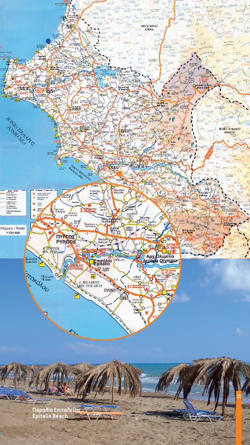
Παραλία ΕπιταλείουEpitalio Beach
23

δημοσ ΓαστουνηΣ Municipality of GastouniΟ δήμος Γαστούνης βρίσκεται στην καρ-
διά της Ηλειακής πεδιάδας και αποτελεί-ται από επτά δημοτικά διαμερίσματα. Ο δήμος Γαστούνης συνορεύει ανατολικά με τον δήμο Αμαλιάδας, βόρεια με τους δήμους Τραγανού και Ανδραβίδας, δυτικά με το δήμο Βαρθολομιού και νότια με το Ιόνιο πέλαγος.
Ο δήμος έχει πληθυσμό 11.523 κατοί-κους, οι οποίοι ασχολούνται -κατά κύριο λόγο- με τη γεωργία, την κτηνοτροφία και το εμπόριο.
Τον επισκέπτη περιμένει ο εκπληκτικός ναός της Παναγίας Καθολικής, η οικία του στρατηγού Σισίνη και η Ιερά Μονή Αγίου Νικολάου στα Καβάσιλα.
Οι παραλίες του δήμου είναι κατάφυτες και ανοιχτές σε κάθε επισκέπτη.
The municipality of Gastouni is at the heart of the Ilian valley and consists of seven municipal departments. The mu-nicipal of Gastouni borders with the mu-nicipal of Amaliada to the east, with the municipals of Tragano and Andravida to the north, with the municipality of Var-tholomio to the west and with the Ionian Sea to the south.
It has a population of 11.523 inhabit-ants, who are mainly occupied with agri-culture, animal husbandry and trading.
The magnificent temple of Panagia Katholiki, as well as the house of General Sisinis and the Holy Temple of Agios Nikolaos in Kavasila, are about to astonish every visitor.
The beaches of the municipality are all green and open to visitors.
Παναγία η Καθολική στη ΓαστούνηChurch of Virgin Mary (Panagia Katholiki) of Gastouni
24

ΑνθεστήριαFlower Festival
25

δημοσ Ζαχαρωσ Municipality of ZacharoΟ δήμος Ζαχάρως αποτελεί το νότιο
σύνορο της Ηλείας με τη Μεσσηνία. Έχει πληθυσμό 12.910 κατοίκους και έδρα τη Ζαχαρώ με 5.407 κατοίκους.
Αποτελεί σπουδαία λουτρόπολη, τόσο για τις υπέροχες και απέραντες αμμουδιές της, όσο και γιατί στα όριά της βρίσκονται τα Ιαματικά λουτρά και η λίμνη Καϊάφα. Τα μεν λουτρά είναι φημισμένα από τη Ρωμα-ϊκή εποχή και οι πηγές τους αναβλύζουν από τις παρυφές του όρους Λαπίθα, η δε λίμνη αποτελεί ένα μνημείο της φύσης καθώς απέχει μόλις 150 μέτρα από το Ιό-νιο Πέλαγος και αποτελεί πολύ σημαντικό υδροβιότοπο, προστατευμένο από τη συν-θήκη RAMSAR.
Η Ζαχάρω απέχει 32 χλμ. από τον Πύργο και διαθέτει σημαντικά αξιοθέατα, όπως:
Οι Ταξιάρχες, όπου διατηρούνται δύο Βυζαντινοί ναοί, το Αρχαίο Κάστρο Λέπρε-ου της προμυκηναϊκής εποχής, ο αρχαι-ολογικός χώρος Κακοβάτου όπου έχουν ανασκαφεί θολωτοί τάφοι, ο αρχαιολογι-κός χώρος Πρασιδακίου όπου βρίσκεται ο Δωρικός Ναός της Αθηνάς και το Φραγκο-Βυζαντινό Κάστρο Αρακλόβου που βρίσκε-ται στο Χρυσούλι στα βόρεια της Μίνθης.
The municipality of Zacharo is the south-ern boundary between Ilia and Messinia. It has a population of 12.910 inhabitants and its capital is Zacharo, numbering 5.407 in-habitants.
Zacharo is considered to be a great city spa, not only because of the endless and wonderful beaches, but also for the medici-nal baths that are found at its boundaries and the lake Kaiafa. While the baths are well known since roman times and their foun-tains spurt from the side of mount Lapithas, the lake is a monument of nature as it is lo-cated 150m far from Ionian Sea and is re-garded as a wetland of great importance, protected by the RAMSAR Treaty.
Zacharo is 32km far from Pyrgos and of-fers many important places of interest, such as:
The Taxiarches, where two byzantine temples are being maintained, the Ancient Castle of Lepreo which is dated back to pro-Mycenaean era, the archaeological site of Kakovatos, where vaulted tombs have been excavated, the archaeological temple of Prasidaki, where the Doric Temple of god-dess Athena is, and the Frankish – Byzan-tine Castle of Araklovos which is in Chrys-ouli, at the northern part of Minthi.
Λίμνη ΚαϊάφαKaiafas lake
26

Παραλία ZαχάρωςZacharo Beach
27

δημοσ ΙαρδανοΥ Municipality of IardanosΟ Δήμος Ιάρδανου βρίσκεται ανάμεσα
στην πρωτεύουσα του νομού, τον Πύργο και στη δεύτερη μεγαλύτερη πόλη την Αμαλιάδα. Διαθέτει εξαιρετικό φυσικό τοπίο που ξεκινά από το ύψος της Κορυ-φής και καταλήγει στο Ιόνιο. Ο ποταμός Ιάρδανος έδωσε το όνομά του στο δήμο και η ιστορία της περιοχής ξεκινά από το 400 π.Χ. όταν κτίστηκε το Κάστρο της Κορυφής (σώζονται και σήμερα ελάχιστα τμήματα του τείχους).
Ο δήμος Ιάρδανου χαρακτηρίζεται από την καλλιέργεια εσπεριδοειδών και στα-φίδας, ενώ ονομαστά είναι τα Πανηγύρια που διοργανώνονται κάθε καλοκαίρι, με πιο ενδεικτικά:
Της Αγίας Μαύρας στο ΒούναργοΤου Αλεποχωρίου και της Ξυλοκέρας τον Δεκαπενταύγουστου.Της Αγίας Τριάδος στη ΒροχίτσαΤου Αγίου Δημητρίου στο ΚατσαρούΤου Αγίου Γεωργίου σε Πράσινο, Φοναΐτι-κα και Κορυφή Των Αγίων Αποστόλων στο ομώνυμο Δη-μοτικό Διαμέρισμα.Πιο σημαντικό μνημείο κι αξιοθέατο του δήμου είναι η Ιερά Μονή Φραγκοπηδήμα-τος, σε υψόμετρο 350 μέτρων, στο δασό-φυτο λοφίσκο του «Αργού», δηλαδή του Λευκού Όρους.
The municipality of Iardanos is between the capital of the peripheral, Pyrgos, and the second in order greater city, Amaliada. It is gifted with an excellent natural land-scape coming up from the heights of Ko-ryfi ending down to the Ionian Sea. The municipality was named after the River Iardanos, while the history of this land goes back to 400 BC. when the Castle of Koryfi was built (very few parts of the wall have been preserved).
The municipality of Iardanos is well known of the cultivation of citrus fruits and raisins, while the Festivals that are be-ing held every summer are very famous, such as:
The Festival of Agia Mavra in Vounargo,of Alepochori and of Xylokera during
the 15th of August,of Agia Triada in Vrochitsa,of Agios Dimitrios in Katsara,of Agios Giorgios in Prasino, Fonaitika
and Koryfi,of Agioi Apostoloi, at the municipal de-
partment Agioi Apostoloi.The most important place of interest in
the municipality is the Holy Temple of Fraggopidima, located at a height of 350m, on the forest-like hill of “Argos”, that is of the Leyko Mountain.
Ιερά Μονή ΦραγκοπηδήματοςMonastery of Fragopidimatos
28

Ποτάμι ΙάρδανοςIardanos river
29

δημοσ Κάστρου κυλληνησ Municipality of Kastro – Kyllini
Ο Δήμος Κάστρου – Κυλλήνης αποτελεί στρατηγικό κόμβο της Περιφέρειας Δυτι-κής Ελλάδας. Το πρώτο, είναι το λιμάνι Κυλλήνης, που αποτελεί την πύλη της Ζα-κύνθου και της Κεφαλονιάς. Το δεύτερο, είναι το καλύτερα διατηρημένο Φράγκικο Κάστρο της Ευρώπης, το Χλεμούτσι, το οποίο δεσπόζει στο λόφο του Κάστρου και εποπτεύει το Ιόνιο και την Ηλειακή Πεδιάδα. Το κάστρο χτίστηκε από τον Γο-δεφρίδο Βιλλεαρδουίνο.
Το τρίτο, είναι η Γλαρέντζα (επίνειο της Αρχαίας Ήλιδας από την οποία απέχει 25 χλμ.). Η Γλαρέντζα κτίστηκε από Αρκάδες και ονομαζόταν Κυλλήνη τα αρχαία χρό-νια. Το όνομά της το πήρε από τον Γοδε-φρίδο Βιλλεαρδουίνο.
Το τέταρτο, είναι οι Ιαματικές Πηγές Λουτρών Κυλλήνης, φημισμένες από τη Ρωμαϊκή εποχή.
Σήμερα, η ξενοδοχειακή υποδοχή του Κάστρου, μπροστά σε μία από τις ομορφό-τερες αμμουδιές της Ευρώπης, αποτελεί πόλο έλξης για χιλιάδες επισκέπτες απ’ όλο τον κόσμο και θεωρείται μία από τις πληρέστερες της χώρας.
The municipality of Kastro – Kyllini is a strategic hub of the Peripheral of the Western Hellas. The first one is the port of Kyllini, which is the gateway to Zakynthos and Cephalonia. The second one is the best preserved Frankish Castle of Europe, Chle-moutsi, which dominates the hill of the Castle and stands over the Ionian Sea and the Valley of Ilia. The castle was built by Geoffrey Villehardouin.
The third one is Glarenza (the port of the Ancient Ilida that is 25km away from). Glarenza was built by Arcadians and was named Kyllini in the ancient years. It was named after Geoffrey Villehardouin.
The fourth one is, the Thermal Springs of Kyllini, which have been famous since the Roman period.
Nowadays, the warm welcoming of the hotels in Kastro, right at the front of one of the most beautiful beaches in Europe, is the center of attraction for thousands of visitors from all over the world and is con-sidered to be one of the best organized in the whole country.
Φάρος ΚυλλήνηςKyllinis Light House
30

Municipality of Kastro – Kyllini
Κάστρο ΧλεμούτσιChlemoutsi Castle
31

δημοσ Λαμπειασ Municipality of Lampeia Η Λαμπεία ή Δίβρη, είναι ένα πανέμορ-
φο ορεινό χωριό της Ηλείας, το οποίο μέ-χρι τα μέσα του 20ου αιώνα έσφυζε από ζωή και αποτελούσε μεγάλο κέντρο εμπορίου και γραμμάτων.
Ο ομώνυμος δήμος Λαμπείας βρίσκεται στο μέσο της εθνικής οδού «111» που ενώνει την Πάτρα με την Τρίπολη, αφού απέχει 86 χλμ. από την Πάτρα και 84 χλμ. από την Τρίπολη. Η οργιώδης βλάστηση, οι πηγές της, η εξαίρετη αρχιτεκτονική των πέτρινων σπιτιών της και οι επτά γει-τονιές της που απλώνονται αμφιθεατρικά κάνουν τη Λαμπεία έναν εξαίρετο προο-ρισμό για κάθε ταξιδιώτη που αποζητά την γαλήνη στην αγκαλιά της φύσης. Ενοικια-ζόμενα δωμάτια, ξενώνες και γραφικές ταβέρνες προσφέρουν μια ευκαιρία από-δρασης όλο το χρόνο.
Lampeia, or also known as Divri, is a beautiful mountainous village of Ilia, which used to be a great center of trade and culture, full of life, up to the midst of the 20th century.
The municipality of Lampeia is right in the middle of the national route “111” which connects Patras with Tripoli, as it is 86km far from the city of Patras and 84km from Tripoli. The lush vegetation, the springs, the extraordinary architec-ture of the stone-houses and the seven neighborhoods that are stretched amphi-theatrically make Lampeia look like an excellent destination for every traveler who seeks peace in nature. Many rooms to let, guest houses and picturesque tav-erns offer a chance for a holiday during any time of the year.
ΔίβρηDivri
32

Μονή ΔίβρηςΜonastery of Divri
33

δημοσ Λασιωνοσ Municipality of LasionΟ δήμος Λασιώνος βρίσκεται στη θέση
της αρχαίας Ακρώρειας της ορεινής Ηλεί-ας, στα σύνορα Ηλείας – Αρκαδίας – Αχα-ΐας. Πήρε το όνομά του από την αρχαία πόλη «Λασιών» που γνώρισε μεγάλη ακμή.
Στο «σώμα» του δήμου βρίσκεται το δρυοδάσος Φολόης που οι κάτοικοι ονο-μάζουν «Κάπελη», δηλαδή «πυκνό και άφθονο δάσος». Η θέα που προσφέρει στον επισκέπτη είναι μοναδική και από τα έξι δημοτικά διαμερίσματα. Έχει έκταση 22.950 στρέμματα και πληθυσμό 2.562 κατοίκους.
The municipality of Lasion is located where the city of ancient Akroreia of the mountainous Ilia used to be, at the borders of Ilia – Arcadia – Achaia. The name Lasion came from the ancient city of Lasion which was once very famous.
The oak-forest Foloi features the main part of the municipality, and some citizens also call it “Kapeli”, which means in Greek “dense and big forest”. The view is spec-tacular and unique from each one of the six municipal departments. It covers an area of 22.950km2 and a popularity of 2.562 citi-zens.
Δρυοδάσος ΦολόηςThe oak forest of Foloi
34

Municipality of Lasion
Πέτρινο γεφύρι Κακοταρίου Kakotari Bridge
35

δημοσ Λεχαινων Municipality of LechainaΟ δήμος Λεχαινών, η γενέτειρα του με-
γάλου πεζογράφου Ανδρέα Καρκαβίτσα, βρίσκεται σε μια στρατηγική θέση του Ηλειακού κάμπου, έχοντας έξι δημοτικά διαμερίσματα.
Με απόσταση 56 χλμ. από την Πάτρα και 40 χλμ. από τον Πύργο, συνορεύει με τους δήμους Βουπρασίας, Ανδραβίδας και Τραγανού ενώ τα όριά του βρίσκονται στα καταγάλανα νερά του Ιονίου Πελάγους.
Έχει 6.500 κατοίκους και φιλοξενεί το μοναδικό οικοσύστημα της λιμνοθάλασ-σας Κοτυχίου. Αποτελεί το ιδανικό ορμη-τήριο για κάθε λάτρη της φύσης.
The municipality of Lechaina, the birth-place of the great Greek proser Andreas Karkavitsas, is located in a strategic place of the Ilian valley, consisting of six munici-pal departments.
It is only 56km far from the city of Pat-ras and 40km from Pyrgos, it neighbors with the municipalities of Vouprasia, An-dravida and Tragano, while at its bounda-ries one can enjoy the deep blue waters of the Ionian Sea.
It has a population of 6.500 inhabitants while it hosts the unique ecosystem of the Kotychio lagoon. Lechaina is the ideal base for everyone who loves nature.
Ο Πολιούχος ΛεχαινώνProtector Saint of M. of Lechaina
36

Η εκδήλωση του ΚαρναβαλιούCarnival festival
37

δημοσ Πηνειασ Municipality of PineiaΟ δήμος Πηνείας αποτελεί έναν από τους
πιο αντιπροσωπευτικούς ημιορεινούς δή-μους της Ελλάδας.
Για πρώτη φορά συγκροτήθηκε το 1835 και σήμερα, αριθμεί 16 δημοτικά διαμερίσματα. Έδρα του δήμου είναι το Σιμόπουλο με 527 κατοίκους, ενώ ο συνολικός πληθυσμός της Πηνείας ανέρχεται σε 5.660 κατοίκους.
Στο περιβάλλον της Πηνείας κυριαρχούν η λίμνη Πηνειού κι ο Πηνειός ποταμός στα βό-ρεια – βορειοδυτικά.
Ο Πηνειακός Λάδωνας, ο ποταμός των μύθων που καθορίζει επί χιλιάδες χρόνια το αγροκτηνοτροφικό περιβάλλον της πε-ριοχής και ο σχηματισμός της Βάλμης, ο οποίος είναι ένας από τους τρεις της Πελο-ποννήσου και αποτελείται από εναλλαγές καφέ και πράσινου αργίλου, άμμο, λάσπη και κροκάλες της παραποτάμιας και της λι-μναίας περιοχής. Τέλος, κυρίαρχο ρόλο στο Πηνειακό περιβάλλον παίζει το μοναδικής ομορφιάς και έκτασης Δρυοδάσος (βελανι-διές) της Κάπελης στα βορειοανατολικά και βόρεια σύνορα του Δήμου. Το μεσογεια-κό κλίμα της περιοχής και η μέση θερμο-κρασία των 19 βαθμών καθιστούν την Πη-νεία ιδανική εκδρομή για όσους αποζητούν την απόλαυση της φύσης. Είτε από την Πά-τρα, μέσω Εθνικής Όδού III, είτε μέσω της υπόλοιπης Ηλείας, είτε μέσω Τρίπολης, η Πηνεία περιμένει όλο το χρόνο τους επι-σκέπτες της.
The municipality of Pineia is one of the most typical half-mountainous municipali-ties in Greece.
It was first found in 1835 and, nowadays, it consists of 16 local departments. The seat of the municipality is Simopoulo, which has 527 inhabitants, while the total number of the population of Pineia is estimated to be 5.660.
The lake of Pineios as well as the River of Pineios dominate the north – northwest part of the municipality of Pineia.
The River Ladonas of Pineia, is the river of the myths that determines for thousands of years the agricultural environment of the area, and the formation of Valmi, which is one of the three in total in Peloponnese, are composed by alternations of brown and green argil, clay and pebbles that belong to the riparian and the lakeside area. Finally, at the northeast and northern boundaries of the Municipality, you can find the Dryo-dasos (forest of oaks) of Kapeli, this unique in beauty and extend forest, which plays the most dominant role in the environment of Pineia. The Mediterranean climate of this area and the average temperature of 19 de-grees Celsius make Pineia the ideal destina-tion for those who seek pleasure in nature. Visitors can reach Pineia either from Patras, through the National Highway III, or by crossing the rest of Ilia, or through the city of Tripoli.
Δήμος ΠηνείαςMunicipality of Pineia
38

Municipality of Pineia
Λίμνη ΠηνειούPineios lake
39

δημοσ ΠΥργοY Municipality of PyrgosΣτο χώρο όπου βρίσκονται σήμερα ο
Πύργος (πρωτεύουσα του νομού Ηλείας) βρισκόταν η Αρχαία Πόλη Δυσπόντιο. Στα περίχωρά του ήταν η αρχαία πόλη Λέτρι-να. Η ονομασία της πόλης προέρχεται από τον πύργο που είχε κατασκευάσει το 1512 στη θέση του Επαρχείου ο Μπέης Γεώργι-ος Τσερνωτάς.
Ο Πύργος αποτέλεσε το κέντρο του Στα-φιδεμπορίου τον 19ο αιώνα και ενδεικτική της σημασίας του τότε, ήταν η εγκατάσταση Προξενείων της Ιταλίας, της Νορβηγίας, των Κάτω Χωρών, της Γερμανίας, της Αυ-στροουγγαρίας, των Η.Π.Α. και της Γαλλί-ας.
Στον Πύργο υπάγεται και το περίφημο λιμάνι Κατακόλου, ένας από τους πιο αναπτυγμένους προορισμούς Κρουαζιε-ρόπλοιων στον κόσμο με περισσότερους από 700.000 επισκέπτες κάθε χρόνο.
Ο Πύργος απέχει 300 χλμ. από την Αθή-να, 20 χλμ. από την Αρχαία Ολυμπία και 100 χλμ. από την Πάτρα και διαθέτει κο-ρυφαίες νοσοκομειακές υποδομές, απέ-ραντες παραλίες και πληρέστατη αγορά. Τα κτήρια που θεάτρου Απόλλων και της Παλαιάς Δημοτικής Αγοράς αποτελούν σπουδαία έργα του αρχιτέκτονα Τσίλλερ, ενώ στον Πύργο εκδίδεται και η δεύτερη αρχαιότερη καθημερινή εφημερίδα της Ελλάδας, η «ΠΑΤΡΙΣ». Η πόλη διαθέτει υπερσύγχρονο Συνεδριακό Κέντρο και πλήθος καλών ξενοδοχείων.
Right where Pyrgos is located (the cap-ital of the peripheral of Ileia) used to be the Ancient City of Dyspontio. At the out-skirts of Dyspontio used to be the Ancient City of Letrina. The name of this city came from the castle that was built in 1512 at the place of the Provence Hall by Mpeis Georgios Tsernotas.
This Castle (Pyrgos, in Greek) was the center of the raisin trade during the 19th century, which was of such a great impor-tance back then that all the Embassies of Italy, Norway, Netherlands, Germany, Austria-Hungary, U.S.A and France, were located there.
The famous port of Katakolo is also lo-cated in Pyrgos, which is one of the most developed destinations for cruise ships in the whole world, as more than 700.000 visitors are estimated to visit Katakolo every year.
Pyrgos is 300km far from Athens, 20km from the Ancient Olympia and 100km from the city of Patras, and has excellent hospi-tal infrastructure, endless beaches and a market where you can purchase anything. The building of the Apollon Theatre as well as the Old Civil Market were designed by the great architect Chiller, while in Pyrgos is being published the second in antiquity daily newspaper of Hellas, “Patris”. The city of Pyrgos has a very modern Congress Center and a number of luxurious hotels.
ΚατάκολοΚatakolo
40

Αρχαιολογικό ΜουσείοΑrchaeological Museum
41

δημοσ σκιλλουντοσ Municipality of SkillountaΟ δ ήμος Σκιλλούντος με έδρα τα Κρέ-
στενα, αποτελείται από 15 δημοτικά διαμε-ρίσματα. Έχει έκταση 194.409 στρέμματα και πληθυσμό 16.000 κατοίκους.
Βρίσκεται στο νότιο τμήμα του νομού Ηλείας και συνορεύει στα βόρεια με τον ποταμό Αλφειό, νότια με το δ ήμο Ζαχάρως, νοτιοανατολικά με το δ ήμο Αλιφείρας, δυ-τικά με το Ιόνιο πέλαγος και βορειοδυτικά με το δ ήμο Βώλακος.
Τα Κρέστενα είναι ο κόμβος που ενώνει την Αρχαία Ολυμπία, το ναό του Επικούρει-ου Απόλλωνα και τον οδικό άξονα Πύργου – Ζαχάρως, όπου σε απόσταση αναπνοής βρίσκονται τα Ιαματικά Λουτρά και η λίμνη Καϊάφα. Περισσότερα από 50.000 στρέμ-ματα δάσους, πλήρεις υποδομές υγείας και υπηρεσιών, χρυσές αμμουδιές και πλήθος πολιτιστικών εκδηλώσεων και αρ-χαιολογικών μνημείων της αρχαίας Σκιλ-λουντίας περιμένουν τους επισκέπτες.
The municipality of Skillounta comprises of 15 municipal departments, and its seat is Krestena. It covers an area of 194.409km2 and it has a population of 16.000 citizens.
It is located at the southern part of the peripheral of Ilia and it borders to the north with the river Alpheios, to the south with the municipality of Zacharo, to the south-east with the municipality of Alifeira, to the west with the Ionian Sea and to the north-west with the municipality of Volakas.
Krestena is the junction that joins the town of Ancient Olympia, the temple of Epikoureios Apollo and the national road Pyrgos – Zacharo, while in a very short dis-tance from there one can also visit the Thermal Spa and the Lake of Kaiafa. A fore-stal area of 50.000km2, fully equipped hospital infrastructures and the archaeo-logical sites of the ancient Skillounta are there, ready to host visitors.
ΚρέστεναKrestena
42

Βίλα ΠαπαλέξηVilla Papalexi
43

ΔΗΜΟΣ ΤΡΑΓΑΝΟΥΑν ο Κάμπος της Ηλείας είναι το επίκε-
ντρο της αγροτικ ής ζω ής του νομού, το Τραγανό είναι ασφαλώς η καρδιά του Κά-μπου. Μια μικρ ή περιοχ ή με μεγάλα πλε-ονεκτήματα. Στο Τραγανό υπάρχει μεγά-λη παράδοση στα τουρσιά, ενώ η περιοχ ή είναι η μοναδικ ή σε ολόκληρη την Ελλά-δα στην παραγωγ ή πιπεριάς για τουρσί. Το Τραγανό παρουσιάζει τεράστιες δυνα-τότητες στην περιοχ ή του ηλειακού Κά-μπου στο ζ ήτημα της στήριξης των ομά-δων παραγωγών, με σωστή σύνταξη και αξιοποίηση των επιχειρησιακών τους προγραμμάτων. Στις απαραίτητες για την ανάπτυξη του Τραγανού υποδομές περι-λαμβάνονται η αντικατάσταση της παλαι-άς γέφυρας Πηνειού, η επέκταση αρδευ-τικού δικτύου στο Τραγανό, η οδικ ή σύνδεση του αεροδρομίου της Ανδραβί-δας με τον Δήμο Τραγανού, η Ίδρυση και λειτουργία εμπορευματικού κέντρου, με κριτήριο την ισόρροπη ανάπτυξη του ηλειακού Κάμπου.
If the municipality of Kampos is the center of the agricultural life of the pe-ripheral of Ilia, then the municipality of Tragano is certainly the heart of Kampos. It is a rather small area with many privi-leges. Tragano is famous for its pickles, as this area is the only one in Greece that pro-duces pickled peppers. Tragano has much potential in the greater area of Kampos as it supports groups of producers by taking advantage of the correct use of their pro-grams of investment. Among the infra-structures that are necessary for the de-velopment of Tragano are included the replacement of the old bridge of Pineios river, the expansion of the irrigation sys-tem in Tragano, the road system that con-nects the airport of Andravida with the municipality of Tragano, the foundation and function of a market center, trying this way to keep the development of the Ilian Kampos in balance.
Municipality of Tragano
Δημαρχείο ΤραγανούTown Hall of Tragano
44

Άγιος ΝικόλαοςChurch of Agios Nikolaos
45

ΔΗΜΟΣ ΦΙΓΑΛΕΙΑΣ Municipality of FigaleiaΟ Δήμος Φιγαλείας αποτελείται από 6
συνολικά Δημοτικά Διαμερίσματα (Νέα Φι-γαλεία, Κρυονέρι, Φιγαλεία, Περιβόλια, Πετράλωνα, Στόμιο) με έδρα τη Νέα Φιγα-λεία και ο πληθυσμός του ανέρχεται στους 2.499 κατοίκους. Καταλαμβάνει έκταση 93,3 χιλ. στρεμμάτων.
Η Φιγαλεία ήταν αρχαία Αρκαδικ ή πόλη, σήμερα διοικητικά ανήκει στον νομό Ηλεί-ας.
Ανήκε στην Παρρασία χώρα, και βρισκό-ταν κτισμένη δίπλα στον ποταμό Νέδα και κοντά στις πόλεις Αλίφειρα και Λυκόσου-ρα. Η θέση της αρχαίας πόλη έχει βρεθεί ανάμεσα στα σημερινά χωριά Φιγάλεια και Περιβόλια στο νομό Ηλείας. Οι ανασκαφές σήμερα βρίσκονται σε εξέλιξη και μέχρι στιγμής έχουν ανασκαφεί τα αρχαία τείχη και ο ναός της Αρτέμιδας.
The municipality of Figaleia consists of 6 Municipal Departments in total (New Fi-galeia, Kryoneri, Figaleia, Perivolia, Petralo-na, Stomio), its seat is Figaleia and it has a population of 2.499 inhabitants. It covers an area of 93,3km2.
Figaleia used to be an ancient Arcadian city, but nowadays it belongs to the periph-eral of Ilia.
It belonged to the Parrasia country, and was built next to the river Neda and close to the cities of Alifeira and Lykosoura. The lo-cation of the ancient city has been found between the villages that are at the present called Figaleia and Perivolia in the periph-eral of Ilia. The area is still being excavated, and up to now, the ancient walls and the Temple of Artemis have come to see the light.
ΝέδαNeda
46

Municipality of Figaleia
Ναός της ΑθηνάςAncient temple of Athena
47

ΔΗΜΟΣ ΦΟΛΟΗΣ Municipality of FoloiΣτην περιοχ ή του Λάλα κατά τη Τουρκο-
κρατία, που ήταν στρατηγικ ής σημασίας διότι από εκεί μπορούσε να ελεγχθεί στρατιωτικά η Ορεινή Ηλεία, η επαρχία Ολυμπίας και η δυτικ ή Γορτυνία κατοι-κούσαν Τουρκαλβανοί. Η νίκη στο Πούσι, που βρίσκεται μόλις έξω από το Λάλα, ήταν καθοριστικ ή για τον Αγώνα στα πρώ-τα βήματά του. Διοργανώνεται κάθε χρό-νο προσκύνημα και εκδηλώσεις στη μνή-μη των πεσόντων στην εκκλησία της Ανάληψης στο Πούσι με συμμετοχ ή πολ-λών επισήμων και κρατικών φορέων και αποτελεί την μεγαλύτερη εορταστικ ή εκ-δ ήλωση στο νομό μας. Ο Λάλας σήμερα ευημερεί και μετατρέπεται σε δ ήμο σύμ-φωνα με το πρόγραμμα «Καποδίστριας».
During the Turkish occupation, at the area called Lalas, which was of great stra-tegic importance as that was the place from which one could military control the Northern Ilia, the province of Olympia and the western part of Gortynia was inhabit-ed by Turk-Albanians. The victory in Pousi, which is located right outside Lalas, was determinant of the first steps of the Rev-olution. Every year, honors are being given for those who died in Pousi at the church of Analipsis and there is a fest in which many official and governmental organs are present, turning this fest into one of the greatest events of the peripheral. La-las is quite prosperous and about to turn into a municipality according to the pro-gram “Kapodistrias”.
Δρυοδάσος ΦολόηςThe oak forest of Foloi
48

Ιστορική Βρύση στη ΝεμούταA historical Fountain of Nemouta
49

δημοσ Ωλένησ Municipality of OleniΟ Δήμος Ωλένης, με έδρα το Καράτουλα,
δανείστηκε το όνομά του από το χωριό Ώλενα, όπου βρισκόταν και η Μεσαιωνική πόλη Ώλενα.
Βρίσκεται στο κέντρο του νομού Ηλείας, δίπλα από την Αρχαία Ολυμπία και αποτε-λείται από 16 δημοτικά διαμερίσματα. Η έκταση του δήμου είναι 152.231 στρέμματα και ο πληθυσμός του 9.045 κάτοικοι. Πρό-κειται για καθαρά αγροτικό δήμο με πεδι-νές και ημιορεινές περιοχές (62 έως 600 μέτρα υψόμετρο). Φημίζεται για το λάδι, τις σταφίδες και τα αμπέλια του.
Αποτελεί τον δήμο που προσφέρει τις πε-ρισσότερες, ίσως, επιλογές διαδρομών πε-ριπατητικού τουρισμού, ενώ φιλοξενεί σπουδαία θρησκευτικά μνημεία, όπως την Ιερά Μονή Παναγίας Κρεμαστής, Ιερά Μονή Αγίου Ιωάννη Προδρόμου Νίκαβας, την Ιερά Μονή Ασκητή κ.λπ.
Το φαράγγι του Γούμερου, το ιστορικό Ολυμπιακό μονοπάτι, ο Βάραγκας και το Τρύπιο Λιθάρι στην Κουτσοχέρα είναι λίγα μόνο από τα σπάνια φυσικά αξιοθέατα του Δήμου.
The municipality of Oleni, the seat of which is Karatoula, was named after the homonym village Olena, where the mediae-val city of Olena used to be.
It is located at the center of the prefec-ture of Ilia, next to the city of Ancient Olym-pia and consists of 16 local departments. It covers an area of 152.231 km2 and its pop-ulation is of 9.045 inhabitants. Oleni is clearly an agricultural municipality with lowland and half-mountainous areas (height ranging between 62 to 600m). Oleni is well known for the oil, the raisins and the grapes that are grown and produced there.
This municipality probably offers the most numerous routes for walking tourism, while at the same time many religious monuments can be found there, such as the Holy Temple of Panagia Kremasti, the Holy Temple of Agios Ioannis Prodromos of Nikava, the Holy Temple of Askiti etc.
The Canyon of Goumeros, the historical Olympic pathway, Varaggas and the Trypio Lithari in Koutsochera, are only few exam-ples of the rare natural places of interest of the Municipality of Oleni.
Μονή KρεμαστήςMonastery of Kremasti
50

Municipality of Oleni
Μονή του ΑσκητήMonastery of Askiti
51

τρεισ ματιεσ από ψηλαΗ βόρεια πλευρά της Ηλείας είναι ένας
από τους μεγαλύτερους αγροτικούς χώ-ρους της Ελλάδας. Είναι η πλευρά που συναντάμε ερχόμενοι από Πάτρα και φι-λοξενεί επτά δήμους και, φυσικά, την Αρ-χαία Ήλιδα. Είναι πεδινή και ποτίζεται από τη λίμνη του Πηνειού. Στις ακτές της έχει αναπτυχθεί μεγάλη ξενοδοχειακή υπο-δομή, ενώ το λιμάνι της Κυλλήνης αποτε-λεί το κύριο πέρασμα προς την Ζάκυνθο
και την Κεφαλονιά. Το φράγκικο κάστρο Χλεμούτσι δεσπόζει στον Ηλειακό κάμπο και προσφέρει εκπληκτική θέα, που φθά-νει από τα σύνορα από την Αχαΐα έως την Κουρούτα και τη νότια πλευρά του Νομού Ηλείας.
Η λιμνοθάλασσα του Κοτυχίου, η λίμνη του Πηνειού αποτελούν ιδανικές ευκαιρίες για επαφή με τη φύση, ενώ τα διεθνούς φήμης αγροτικά προϊόντα (φρά-ουλες, καρπούζια, πεπόνια κ.λπ.) που παράγονται στον Ηλειακό Κάμπο δίνουν ξεχωριστή γεύση και ποιότητα στις καλο-καιρινές διακοπές.
52

three overviews from IliaThe northern part of the prefecture of
Ilia is one of the biggest agricultural dis-tricts in Greece. This is the part that we come across on our way from the city of Patra, which hosts seven municipalities and, of course, the Ancient Elis. It is a low-land area and it is being watered by the lake of Pineios. Along the coast, there are great hotel infrastructures, while the port of Kyllini is the main gateway to the is-
lands Zakynthos and Kefalonia. The Frank-ish Castle of Chlemoutsi dominates the valley of Ilia and offers a unique view, which stretches to the boundaries, from Achaia to Kourouta, and to the southern side of the prefecture of Ilia.
The lagoon of Kotychi and the lake of Pineios, are the ideal chances to get in touch with nature, while the worldwide popular agricultural products (strawber-ries, watermelons, melons etc.) that are being produced in the Ilian valley, give a special flavor and quality to your summer vacation.
53

Από το βουνό του Κατακόλου, ο επι-σκέπτης απολαμβάνει τη θέα της περιο-χής του Δήμου Πύργου, του Δήμου Ιάρδα-νου και του Δήμου Βώλακος. Τα πιο ξεχωριστά σημεία αυτής της οπτικής πε-ριπλάνησης είναι η απέραντη παραλία Κατακόλου - Σπιάντζας - Επιταλείου, το δέλτα του Πηνειού, τα έφορα εδάφη της αποξηραμένης λίμνης Αγουλινίτσας. Ένα μαγευτικό ηλιοβασίλεμα προς τη μεριά
Visitors can enjoy the view from the mountain of Katakolo, to the land of the municipality of Pyrgos, the municipality of Iardanos and of Volakos. The most dis-tinguishing parts of this optical tour are the endless beach of Katakolo – Spiantza – Epitalio, the delta of Pineios and the fer-tile land of the dry lake of Agoulinitsa. A magnificent sunset towards the bay of Agios Andreas will reward those visitors
του όρμου του Αγίου Ανδρέα θα ανταμεί-ψει τον ταξιδιώτη που ψάχνει για μοναδι-κές στιγμές. Η πλήρης παραλιακή, αλλά και αστική (Πύργος) ξενοδοχειακή υπο-δομή της περιοχής καλύπτει κάθε απαίτη-ση. Μοναδικό θέαμα αποτελούν τα μεγά-λα κρουαζιερόπλοια που «δένουν» στο λιμάνι του Κατακόλου αποβιβάζοντας πε-ρισσότερους από 700.000 επισκέπτες κάθε χρόνο. Στις πολυάριθμες ψαροτα-βέρνες της περιοχής όλοι μπορούν να απολαύσουν αξέχαστες γεύσεις.
Στις εκβολές (δέλτα) του Αλφειού, όσοι αγαπούν το περπάτημα στη φύση θα βρούν σίγουρα τη δική τους διαδρομή.
who seek for special moments. The com-plete, coastal, but also urban hotel infra-structure of the area meets every kind of request. The large cruising boats that moor at the port of Katakolo are a spec-tacular thing to see, as they discharge more than 700.000 passengers every year. At the numerous fish-taverns of the area, everyone can taste delicious meals.
At the delta of Alpheios River, those who love walking in nature will definitely find their own path.
54