The Mycenaean drainage works of north Kopais, …...Chalkis (Stephani Byzantii, Ethnica, 2. 591)....
13
The Mycenaean drainage works of north Kopais, Greece: a new project incorporating surface surveys, geophysical research and excavation E. Kountouri 1 , N. Petrochilos 1 , N. Liaros 1 , V. Oikonomou 1 , D. Koutsoyiannis 2 , Ν. Mamassis 2 , N. Zarkadoulas 2 , A. Vött 3 , H. Hadler 3 , P. Henning 3 , T. Willershäuser 3 1 Ministry of Education and Religious Affairs, Culture and Sports, Greece 2 Department of Water Resources and Environmental Engineering, National Technical University of Athens, Greece 3 Institute for Geography, Johannes Gutenberg-Universität Mainz, Johann-Joachim-Becher-Weg 21, 55099 Mainz, Germany Abstract The attempt to drain the Kopais Lake was one of the most impressive and ambitious technical works of prehistoric times in Greece, inspiring myths and traditions referring to its construction and operation. The impressive remnants of the Mycenaean hydrau- lic works represent the most important land reclamation effort during prehistoric Greek antiquity, attracting thus the attention of the international scientific community. Nevertheless, in spite of the minor or extended contemporary surveys, the picture of the prehistoric drainage works in Kopais has remained ambiguous. Concerning the function of these works and their precise date within the Bronze Age, the proposed theories were based solely on indications from surface survey; data stemming from ar- chaeological or geophysical research methods have been largely neglected. The new interdisciplinary project focusing on the interpretation of the Mycenaean drainage works of Kopais is conducted. This paper presents the results of the first study season. Keywords: Drainage systems; Hydraulic works; Kopais; Mycenaean civilization Introduction The attempt to drain the Kopais Lake was one of the most impressive and ambitious technical works of prehistoric times in Greece. The size and the importance of this achievement inspired myths and traditions referring to its construction and operation, as well as to its final destruction, which has been attributed to Heracles (Diod. Sic., 4.18.7 “… but in Boeotia he did just the opposite and damming the stream which flowed near the Minyan city of Orchomenos he turned the country into a lake and caused the ruin of that whole region. But what he did in Thessaly was to confer a benefit upon the Greeks, whereas in Boeotia he was exacting punishment from those who dwelt in Minyan territory, because they had enslaved the Thebans ….”). Mycenaean Boeotia and the Kopais Lake Being located on the crossroads connecting the Peloponnese and Attica to the north of Greece (Fig. 1), Boeotia is one of the most important regions of Mycenaean Greece (1600-1100 BC), as borne out by the finds from excavations and its significant place in mythology and ancient traditions. The geographical division of the Boeotian plain into two parts surrounded by mountainous massifs reflects also the political reality of My- cenaean Boeotia: in the northern part, which includes the Kephisos valley and the Kopais basin, Orchomenos was the major center surrounded by a network of smaller
Transcript of The Mycenaean drainage works of north Kopais, …...Chalkis (Stephani Byzantii, Ethnica, 2. 591)....
The Mycenaean drainage works of north Kopais, Greece: a new project
incorporating surface surveys, geophysical research and excavation
E. Kountouri1, N. Petrochilos1, N. Liaros1, V. Oikonomou1, D. Koutsoyiannis2, Ν. Mamassis2, N.
Zarkadoulas2, A. Vött3, H. Hadler3, P. Henning3, T. Willershäuser3 1 Ministry of Education and Religious Affairs, Culture and Sports, Greece 2 Department of Water Resources and Environmental Engineering, National Technical University of
Athens, Greece 3 Institute for Geography, Johannes Gutenberg-Universität Mainz, Johann-Joachim-Becher-Weg 21,
55099 Mainz, Germany
Abstract
The attempt to drain the Kopais Lake was one of the most impressive and ambitious
technical works of prehistoric times in Greece, inspiring myths and traditions referring
to its construction and operation. The impressive remnants of the Mycenaean hydrau-
lic works represent the most important land reclamation effort during prehistoric
Greek antiquity, attracting thus the attention of the international scientific community.
Nevertheless, in spite of the minor or extended contemporary surveys, the picture of
the prehistoric drainage works in Kopais has remained ambiguous. Concerning the
function of these works and their precise date within the Bronze Age, the proposed
theories were based solely on indications from surface survey; data stemming from ar-
chaeological or geophysical research methods have been largely neglected. The new
interdisciplinary project focusing on the interpretation of the Mycenaean drainage
works of Kopais is conducted. This paper presents the results of the first study season.
Keywords: Drainage systems; Hydraulic works; Kopais; Mycenaean civilization
Introduction
The attempt to drain the Kopais Lake was one of the most impressive and ambitious
technical works of prehistoric times in Greece. The size and the importance of this
achievement inspired myths and traditions referring to its construction and operation,
as well as to its final destruction, which has been attributed to Heracles (Diod. Sic.,
4.18.7 “… but in Boeotia he did just the opposite and damming the stream which flowed near
the Minyan city of Orchomenos he turned the country into a lake and caused the ruin of that
whole region. But what he did in Thessaly was to confer a benefit upon the Greeks, whereas in
Boeotia he was exacting punishment from those who dwelt in Minyan territory, because they
had enslaved the Thebans ….”).
Mycenaean Boeotia and the Kopais Lake
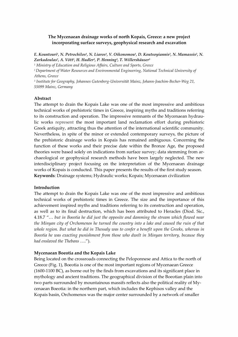
Being located on the crossroads connecting the Peloponnese and Attica to the north of
Greece (Fig. 1), Boeotia is one of the most important regions of Mycenaean Greece
(1600-1100 BC), as borne out by the finds from excavations and its significant place in
mythology and ancient traditions. The geographical division of the Boeotian plain into
two parts surrounded by mountainous massifs reflects also the political reality of My-
cenaean Boeotia: in the northern part, which includes the Kephisos valley and the
Kopais basin, Orchomenos was the major center surrounded by a network of smaller
2
satellite settlements; in the southern part with the extensive fertile plain of Thebes, the
plains of Asopos, Tanagra and the coast of the Euboean Gulf, Thebes was dominant,
being supported by an analogous regional settlement pattern.
Fig. 1: Map of the Boeotian Kephisos basin and the former Kopais Lake (grey area be-
tween Gla and Orchomenos) at the center of mainland Greece.
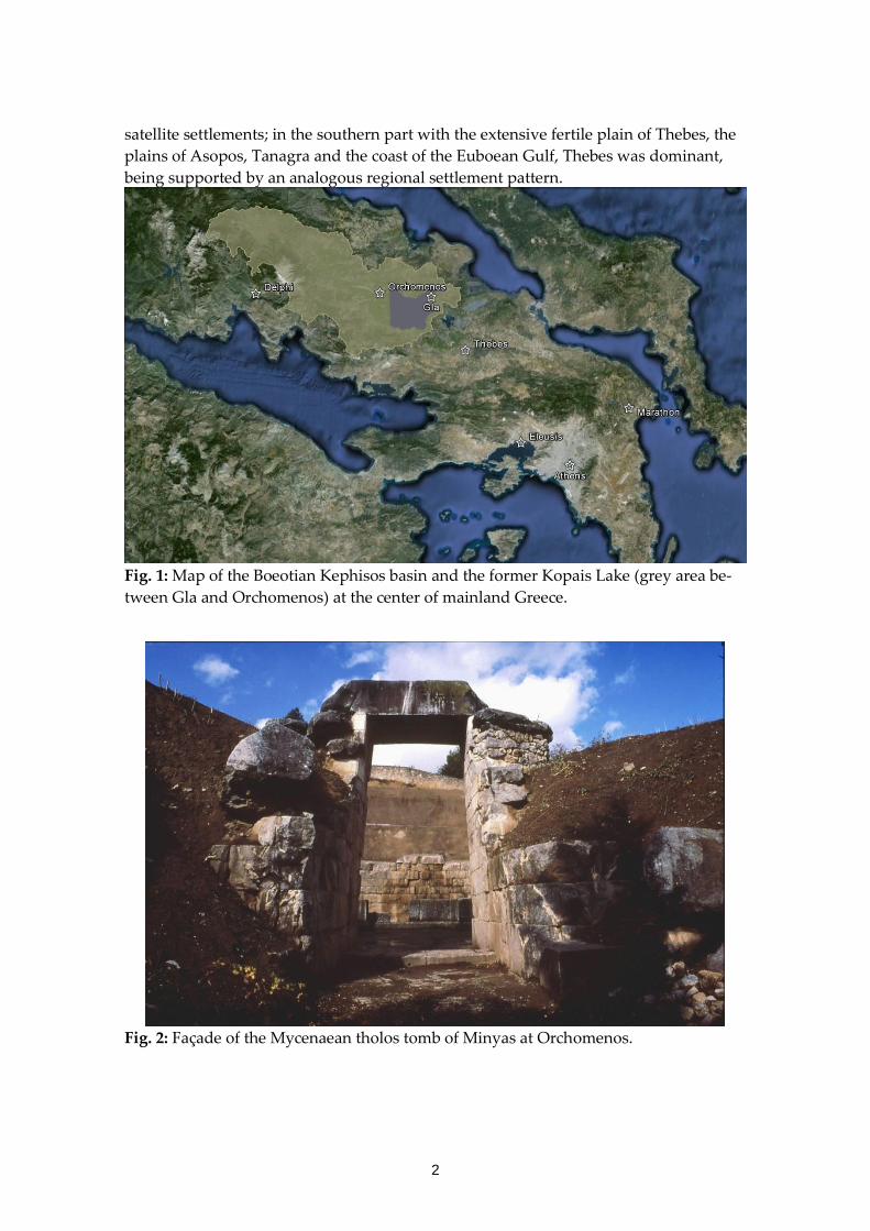
Fig. 2: Façade of the Mycenaean tholos tomb of Minyas at Orchomenos.
3
Excavation evidence and historical tradition attest (e.g. Bulle 1907; Iakovidis 1995) that
the most important centre in northern Boeotia was Orchomenos, lying in the northwest
corner of the Kopais lake/plain. A mainland and primarily a lakeside power, Or-
chomenos turned its attention mostly towards central Greece aiming for the control of
the unique natural resources at hand. Overseas relationships do not seem highly im-
portant. The sporadic archaeological investigations in Orchomenos have brought to
light only few remains of the Mycenaean settlement. The finds, however, indicate its
special flourish. (Schliemann 1881; Papazoglou-Manioudaki 1990) (Fig. 2).
In the memory of the ancients, the legendary wealth of Orchomenos was due to the
cultivation and exploitation of the drained Kopais Lake (Il. 9.381; Str. 9.2.40.). The pow-
er and plenty enjoyed by Orchomenos lasted, according to ancient myth, until Heracles
took vengeance on the King of Orchomenos: the famous hero blocked the exit of the
Kephisos River towards the sea flooding the Kopais once again (Apollod. 2.4.11, Diod.
Sic. 4.18.6).
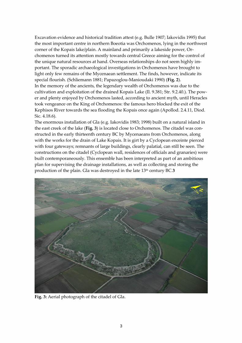
The enormous installation of Gla (e.g. Iakovidis 1983; 1998) built on a natural island in
the east creek of the lake (Fig. 3) is located close to Orchomenos. The citadel was con-
structed in the early thirteenth century BC by Mycenaeans from Orchomenos, along
with the works for the drain of Lake Kopais. It is girt by a Cyclopean enceinte pierced
with four gateways; remnants of large buildings, clearly palatial, can still be seen. The
constructions on the citadel (Cyclopean wall, residences of officials and granaries) were
built contemporaneously. This ensemble has been interpreted as part of an ambitious
plan for supervising the drainage installations, as well as collecting and storing the
production of the plain. Gla was destroyed in the late 13th century BC.3
Fig. 3: Aerial photograph of the citadel of Gla.
4
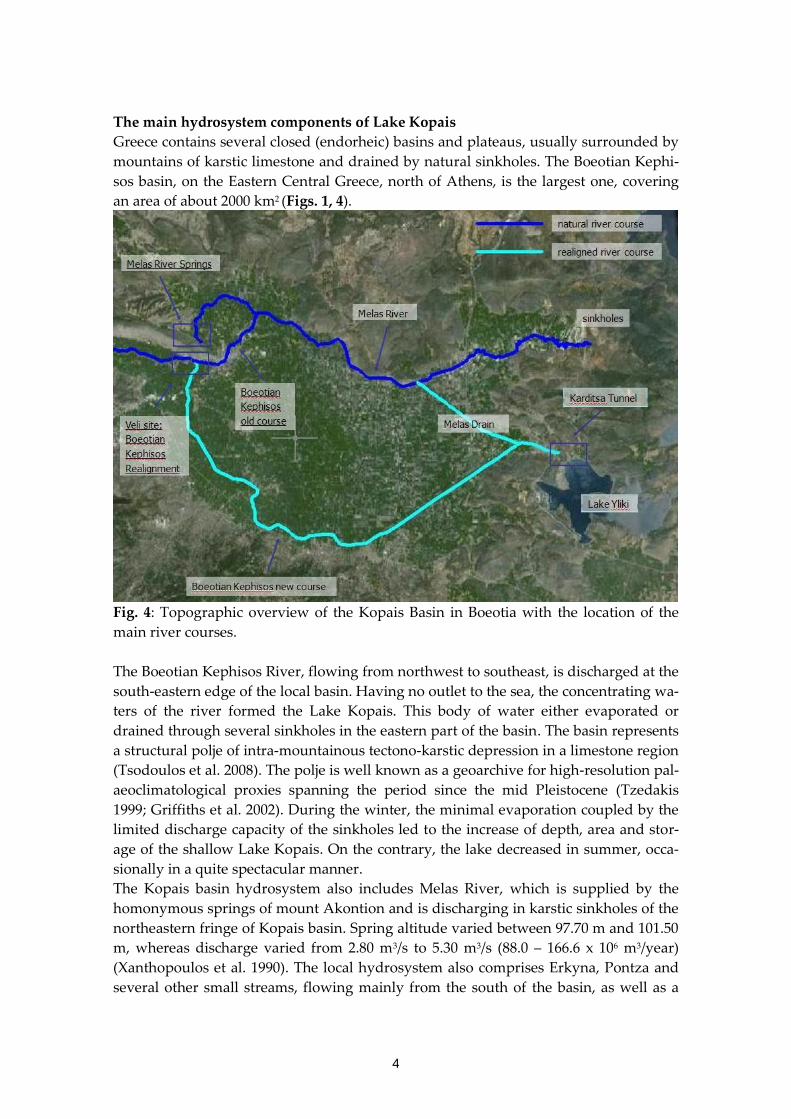
The main hydrosystem components of Lake Kopais
Greece contains several closed (endorheic) basins and plateaus, usually surrounded by
mountains of karstic limestone and drained by natural sinkholes. The Boeotian Kephi-
sos basin, on the Eastern Central Greece, north of Athens, is the largest one, covering
an area of about 2000 km2 (Figs. 1, 4).
Fig. 4: Topographic overview of the Kopais Basin in Boeotia with the location of the
main river courses.
The Boeotian Kephisos River, flowing from northwest to southeast, is discharged at the
south-eastern edge of the local basin. Having no outlet to the sea, the concentrating wa-
ters of the river formed the Lake Kopais. This body of water either evaporated or
drained through several sinkholes in the eastern part of the basin. The basin represents
a structural polje of intra-mountainous tectono-karstic depression in a limestone region
(Tsodoulos et al. 2008). The polje is well known as a geoarchive for high-resolution pal-
aeoclimatological proxies spanning the period since the mid Pleistocene (Tzedakis
1999; Griffiths et al. 2002). During the winter, the minimal evaporation coupled by the
limited discharge capacity of the sinkholes led to the increase of depth, area and stor-
age of the shallow Lake Kopais. On the contrary, the lake decreased in summer, occa-
sionally in a quite spectacular manner.
The Kopais basin hydrosystem also includes Melas River, which is supplied by the
homonymous springs of mount Akontion and is discharging in karstic sinkholes of the
northeastern fringe of Kopais basin. Spring altitude varied between 97.70 m and 101.50
m, whereas discharge varied from 2.80 m3/s to 5.30 m3/s (88.0 – 166.6 x 10⁶ m3/year)
(Xanthopoulos et al. 1990). The local hydrosystem also comprises Erkyna, Pontza and
several other small streams, flowing mainly from the south of the basin, as well as a
5
variety of springs. The mean total annual discharge of the springs of the Boeotian
Kephisos is currently about 300 x 106 m3/year, but it used to be higher at the beginning
of the 20th century (about 380 x 106 m3/year). The altitude of the lake’s bottom was 84
m a.s.l. and it did not exceed 92 m a.s.l. in its greater part. The water level of the lake
was determined by the elevation of the sinkholes, usually not exceeding 97 m a.s.l. The
lake covered an area ranging from 150 km2 to 250 km2 (Constantinidis 1984). During the
floods of 1852 and 1864, water level exceeded 97 m, resulting in the flooding of about
20 km2 of the neighboring Levadeia basin, whereas the year 1856 drought led to the
complete draining of the lake.
Prior to the construction of the 19th century drainage infrastructures, the Boeotian
Kephisos emerged from the mountain valley onto Kopais river basin at Pyrgos, NE of
Skripou – Petromagoula, joining the Melas river bed. The combined flow was slowly
accumulated towards the great sinkholes of Kephalari, south of Topolia village. The
Mycenaean drainage works were exactly based on this natural mechanism. Hence, the
Mycenaean inhabitants of Orchomenos, in their efforts to secure arable land, must have
realized that their main purpose should be to convey the combined discharge of Boeo-
tian Kephisos and Melas away from the Kopais basin, towards the sinkholes to the
northeast.
Subsequent attempts to drain Kopais: historical notes
Among several subsequent attempts to drain Kopais, an unfinished tunnel in the
northeast part of the basin close to the sinkholes stands out: the so-called Kephalari
pass has been dated to the Mycenaean period (Knauss 1991). However, there is a
strong possibility that the tunnel was constructed much later, during the Hellenistic
age. In such a case, it could be considered as part of the drainage works that Alexander
the Great has assigned to Krates, his chief engineer who originated from the nearby
Chalkis (Stephani Byzantii, Ethnica, 2. 591). During Roman times, at least two attempts
to drain Kopais are documented: first by Epameinondas Epameinondou, a prosperous
local from the ancient Akraiphia (Oliver 1971), and then by the Emperor Hadrian
(Boatwright 2000).
At the end of the 19th century, initially a French and then an English company (Κara-
vasili 2000, Grypari 2000, Karavasili et al. 1996) constructed the extended drainage
network of canals, drains and levees, as well as the Karditsa diversion tunnel, which
drained the lake by diverting the water into the adjacent lake Hylike. This was the first
major hydraulic project in the Modern Greek state. As part of this project, the part of
the Boeotian Kephisos downstream of the site Veli was realigned through an artificial
channel (known as Grand Canal, Canal in the March or Emissary Canal). The carto-
graphical and topographical surveys conducted by the French and English engineers of
the companies that undertook the works to dry up the Lake have brought ground in
the study of the Kopais’ basin history (for the previous research in Kopais see Curtius
1892, Kambanis 1892, Kambanis 1893, Kenney 1935; Kahrstedt 1937; Wallace 1979). The
impressive remnants of the Mycenaean hydraulic works that were discovered repre-
sent the most important land reclamation effort of prehistoric Greek antiquity, reason-
ably attracting the attention of the international scientific community. Nevertheless, in
spite of the minor or extended surveys that followed (e.g. Lauffer 1938/1939; 1939;
6
1940; 1985; 1986), the picture of the prehistoric drainage works in Kopais had remained
ambiguous. The theories (Knauss et al. 1984) that have been proposed concerning the
function and the precise date of the works within the Bronze Age, were based solely on
indications from surface survey and not on data stemming from archaeological or geo-
physical research methods. Furthermore, the representation of the operational scheme
of the Mycenaean hydraulic works is admittedly a quite difficult task: these works co-
exist with (i) several subsequent and possibly incomplete attempts to drain the lake
over the centuries (e.g. Oliver 1971; Oliver 1989; Boatwright 2000), plus (ii) the existing
19th and 20th century drainage infrastructures.
The New Kopais project: first fieldwork results
The new interdisciplinary project focusing on the interpretation of the Mycenaean
drainage works, is realized by the Hellenic Ministry of Education and Religious Af-
fairs, Culture and Sports in collaboration with the Department of Water Resources and
the Environmental Engineering of the National Technical University of Athens
(Greece) and the Institute of Geography of the University of Mainz (Germany). The
project aspires to answer several queries about the technological background of the in-
spired technical work in Kopais. Additionally, a series of hydraulic and hydrological
analyses attempts to extract the exact operational scheme of the works. The field
works, undertaken during the summer of 2011, comprise archaeological surface sur-
vey, topographical mapping, geophysical survey, subsurface sampling of soils and
three-dimensional terrestrial laser scanning, all combined with exploratory archaeolog-
ical excavations in selected areas. The results of the first field season provided new ev-
idence on the construction, the course, the size and mainly the dating of the Mycenaean
hydraulic works.
This year a total area of 67.5 km2 was covered, stretching from Orchomenos in the west
to the modern village of Kastro in the east, and from the limestone slopes of the basin
in the north to the village of Agios Demetrios in the south. Starting from the focal point
of the segments of the wall excavated by the first author at the site of Anteras, the My-
cenaean levee walls were traced and mapped west, towards Orchomenos, for a length
of 2.5 km, and east, in the direction of the village Kastro, for 8.5 km. In addition, the
Pyrgos, Stroviki, and Tourlogiannis hills were explored for possible auxiliary installa-
tions of the Mycenaean hydraulic works, such as guard posts or small forts. At the
same time, smaller drainage works and man-made water storage areas postulated by
other scholars (Knauss 1984) were sought in the entire aforementioned region. Four
new archaeological sites dating to the Classical, Roman and Post-Byzantine periods
were located and mapped with GPS, in the northwestern section of the basin. Their
particular geographical position seems especially important, for it is related to the fluc-
tuations of the water levels of the lake during the periods when the water management
systems were in operation.
Several initial findings were verified by the preliminary hydrological analysis and the
geoarchaeological research. The geo-scientific studies carried out in the Kopais basin
by the Institute of Geography of the University of Mainz comprised of vibracoring us-
ing an Atlas Copco Cobra mk 1 coring device. The maximum recovery depth reached 7
m below surface with core diameters of 6 and 5 cm. Photo-documentation, description
7
and sampling of the retrieved cores were carried out in the field. Core description in-
cluded the analyses of grain size, sediment colour, calcium carbonate content and no-
ticeable features such as plant and macrofaunal remains or ceramic fragments.. For the
geochemical analyses, X-ray fluorescence measurements (XRF) were carried out during
fieldwork using a hand-held XRF analyzer [type Thermo Niton Xl3t 900S, calibration
mode SOIL]. Measurements were taken every 5 cm, wherever possible, in order to ob-
tain a detailed vertical distribution pattern for the stratigraphical record. Earth Resis-
tivity Tomography [ERT] measurements were carried out at different locations to de-
tect buried segments of the Mycenaean wall and/or sedimentary structures below pre-
sent ground surface. ERT transects were orientated perpendicular to the assumed
course of the levee according to the survey that had been preceded. The position and
elevation of the coring sites and the ERT transects were measured (by means of a
TOPCON HiperPro FC-250 DGPS device), and the older stratigraphical excavations,
can be set forth.
An initial overview based on the findings of the first field season
First, at the site of Romeiko, around 2.5 km northeast of Orchomenos, one of the two
branches of the lower reaches of Boeotian Kephisos River was diverted from its old bed
to a new one, shared with the Melas River; the second branch of the Kephisos contin-
ued to flow into the western margin of the Kopais basin. This diversion is likely to have
been the work of the Mycenaeans. By diverting part of Boeotian Kephisos and Melas
Rivers towards the sinkholes existing along the banks of the basin, the water level and
the area of the lake were reduced; consequently, the northern portion of the basin
could be turned over to cultivation.
Second, the diversion was accomplished with the aid of a robust levee, carved in a
west-east direction, from the area of Orchomenos towards the sinkholes of the north-
eastern cove. The levee ran along the northern edge of the lake, in proximity to the
limestone slopes of the basin. It was also setting the boundaries of the region flooded
by the waters of Boeotian Kephisos and Melas Rivers, before these were being emptied
into the sinkholes. In effect, the levee worked as a barrier and water retention dam at
possibly the highest rim of the basin, allowing the land on the other side to be dry for
agricultural exploitation.
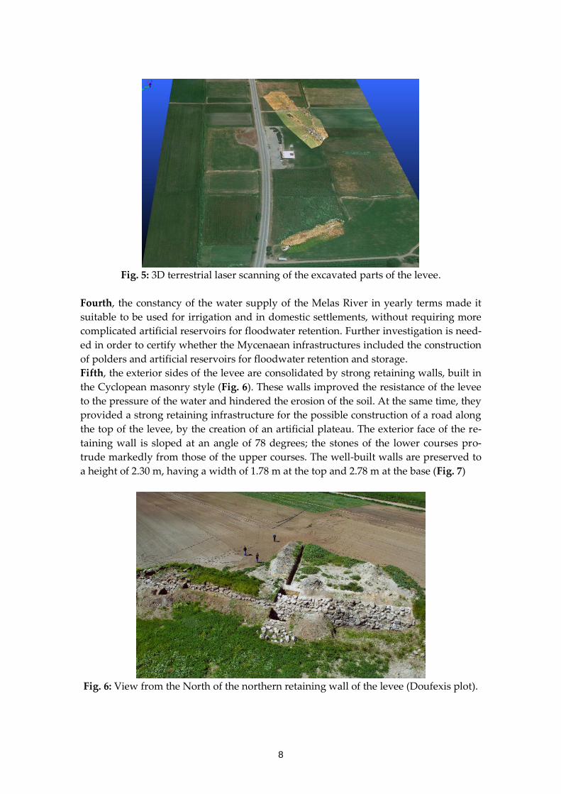
Third, in the portion that was investigated, the levee’s course appears to follow, in
parts, the modern country road linking Kastro and Orchomenos, as well as a farm road
leading towards the village of Pyrgos. The remains of the levee discovered during the
modern widening of the country road between Kastro and Orchomenos, as well as the
stratigraphy of the excavations taken place in the site of Anteras, confirm the afore-
mentioned course (Fig. 5). The terminal point of the levee to the west, near Orchome-
nos, was not determined during this year’s field work. Notably, the aquifer that feeds
the Melas springs has a significant storage capacity and extends to a depth of at least
100 m; therefore, the spring discharge is high even in dry periods.
8
Fig. 5: 3D terrestrial laser scanning of the excavated parts of the levee.
Fourth, the constancy of the water supply of the Melas River in yearly terms made it
suitable to be used for irrigation and in domestic settlements, without requiring more
complicated artificial reservoirs for floodwater retention. Further investigation is need-
ed in order to certify whether the Mycenaean infrastructures included the construction
of polders and artificial reservoirs for floodwater retention and storage.
Fifth, the exterior sides of the levee are consolidated by strong retaining walls, built in
the Cyclopean masonry style (Fig. 6). These walls improved the resistance of the levee
to the pressure of the water and hindered the erosion of the soil. At the same time, they
provided a strong retaining infrastructure for the possible construction of a road along
the top of the levee, by the creation of an artificial plateau. The exterior face of the re-
taining wall is sloped at an angle of 78 degrees; the stones of the lower courses pro-
trude markedly from those of the upper courses. The well-built walls are preserved to
a height of 2.30 m, having a width of 1.78 m at the top and 2.78 m at the base (Fig. 7)
Fig. 6: View from the North of the northern retaining wall of the levee (Doufexis plot).
9
Fig. 7. Section of the northern retaining wall of the levee.
Given the quantity of stones found in the destruction layers, an original height of over
3 m can be postulated. The walls were created using large boulders placed in roughly
regular courses, with smaller stone chips used as filling. Initially, a foundation trench
was dug consisting of a shallow ditch. This was somewhat wider than the retaining
wall and it was filled with small stones set into a thick layer of clay. Above this water-
proof insulating infrastructure, the stones of the first courses were laid, supplemented
by a clay filling in between the joints. The rest of the retaining wall was constructed on
top of this course. Unlike the exterior face of the wall, the interior facade was erected
vertically, without any particular aesthetic attention; it was filled with uncut boulders
protruding and receding at random, and a thick mass of small to medium stones and
clay.
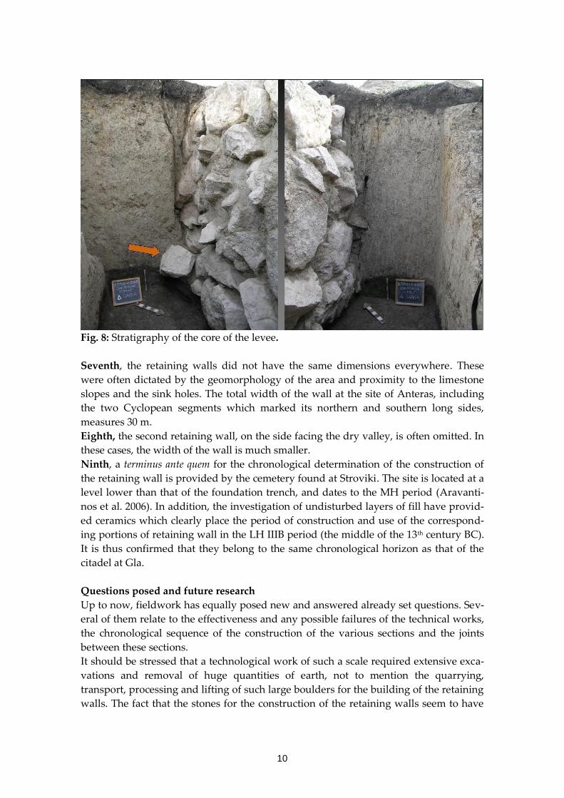
Sixth, the core of the retaining wall makes extensive use of yellowish clay originating
from lake deposits, which is characterized by plasticity and waterproof qualities. A
thick and compact layer of this clay, measuring a total of 2 m thick, reaches down to
the foundation trench of the retaining wall; the layer was completely devoid of any ce-
ramic material (Fig. 8). In a certain case, at the lowest level of this layer of clay, a large
stone was found, having fallen from a higher course of the retaining wall. Around it, a
small quantity of stone chips indicates that the boulders were roughly hewn on the
spot.
10
Fig. 8: Stratigraphy of the core of the levee.
Seventh, the retaining walls did not have the same dimensions everywhere. These
were often dictated by the geomorphology of the area and proximity to the limestone
slopes and the sink holes. The total width of the wall at the site of Anteras, including
the two Cyclopean segments which marked its northern and southern long sides,
measures 30 m.
Eighth, the second retaining wall, on the side facing the dry valley, is often omitted. In
these cases, the width of the wall is much smaller.
Ninth, a terminus ante quem for the chronological determination of the construction of
the retaining wall is provided by the cemetery found at Stroviki. The site is located at a
level lower than that of the foundation trench, and dates to the MH period (Aravanti-
nos et al. 2006). In addition, the investigation of undisturbed layers of fill have provid-
ed ceramics which clearly place the period of construction and use of the correspond-
ing portions of retaining wall in the LH IIIB period (the middle of the 13th century BC).
It is thus confirmed that they belong to the same chronological horizon as that of the
citadel at Gla.
Questions posed and future research
Up to now, fieldwork has equally posed new and answered already set questions. Sev-
eral of them relate to the effectiveness and any possible failures of the technical works,
the chronological sequence of the construction of the various sections and the joints
between these sections.
It should be stressed that a technological work of such a scale required extensive exca-
vations and removal of huge quantities of earth, not to mention the quarrying,
transport, processing and lifting of such large boulders for the building of the retaining
walls. The fact that the stones for the construction of the retaining walls seem to have
11
been hewn in place requires organized teams of personnel with clear and distinct re-
sponsibilities; at the same time, it presupposes the existence of a steady flow of sup-
plies. All of the above support the case that there must have been a particularly strong
and centralized authority in the region. Should we consider Orchomenos as that cen-
tral power mobilizing human resources, means and materials for the design, the con-
struction and the logistics of such a prestigious work? Or are we facing a case of coop-
eration between certain powers of the time, including the other powerful administra-
tive centre in the region, Thebes? For the time being, the former hypothesis seems more
possible.
Future fieldwork will focus on (1) further locating the western starting as well as the
eastern terminal point of the levee, along with any secondary works, (2) identifying
specific construction details of the levee, (3) excavating more selected sites in order to
confirm the chronological framework, and (4) clarifying the exact operational hydraulic
pattern of the works.
References
Aravantinos, V., Kountouri E., Fappas I. 2006 Το Μυκηναϊκό Αποστραγγιστικό
Σύστημα της Κωπαϊδας: νέα δεδομένα και πρώτες εκτιμήσεις (The Mycenaean
drainage system of Copais: new data and first estimations). Proceedings of the Sec-
ond International Conference on Ancient Greek Technology, Athens, pp. 557-564.
Boatwright M. 2000 Hadrian and the cities of the Roman Empire, Princeton University
Press, New Jersey.
Bulle Η. 1907 Orchomenos I: die älteren Ansiedlungsschicten (Orchomenos I: The earliest lay-
ers of the settlement), Verlag der K.B. Akademie der wissenschaften, München.
Constantinidis D. 1984 Έκθεση 1η: Οριστική Μελέτη (Εφαρμογής) Αντιπλημμυρικών
Έργων Λεκάνης Βιοωτικού Κηφισού του Υπουργείου Δημοσίων Έργων,
Μελετητής: Γραφείο Δημ. Θ. Κωνσταντινίδης (Report 1: Final Design of the flood
protection works in the Boeoticos Kephisos river basin, Commissioner: Ministry of
Public Works, Contractor: D. Constantinidis), Athens
Curtius E. 1892 Die Deichbauten der Minyer (The dykes of the Minyans). Sitzungsber-
icht der Berliner Akademie der Wissenschaften, Philos- Histor. Klasse, Bd. 55, 1181-
1193.
Griffiths S. J., Street-Perrott F.A., Holmes J.A., Leng M.J., Tzedakis C., 2002 Chemical
and isotopic composition of modern water bodies in the Lake Kopais Basin, cen-
tral Greece: analogues for the interpretation of the lacustrine sedimentary se-
quence. Sedimentary Geology, 148, 79-103.
Grypari M. 2000 Αποκατάσταση, Αξιοποίηση και ένταξη των διατηρητέων
εγκαταστάσεων της Lake Copais Co. Ltd. σε πρόγραμμα ανάδειξης της
διαχρονικής ιστορίας της Κωπαϊδας (Reconstruction, development and integra-
tion of the preserved facilities of «Lake Copais co. Ltd.» in the program repre-
senting the diachronic history of Copais). Εpeteris tes Etaireias Boiotikon Meleton,
1042-1064.
Iakovidis S. 1995 Γλας και Ορχομενός (Gla and Orchomenos). Ιn Εpeteris tes Etaireias
Boiotikon Meleton, vol. B, part a, Proceedings of the Second International Conference of
Boeotian Studies, Athens, pp.69-81.
12
Iakovidis S. 1983 LH Citadels on Mainland Greece, E.J. Brill, Leiden.
Iakovidis S. 1998 Γλας ΙΙ: Η ανασκαφή 1981-1991 (Gla II: the excavation of the years 1981-
1991), The Archaeological Society at Athens, Athens.
Kahrstedt U. 1937 Der Kopaissee im Altertum und die «Minyschen» Kanäle (The lake
Copais in antiquity and the «Minyan» canals). Archäologischer Anzeiger, 52, 1-19.
Kambanis M. 1892 Le dessèchement du lac Copais par les anciens (The drainage of the
Kopais lake by the ancients), Bulletin de Correspondance Hellenique, 16, 121-137;
Kambanis M. 1893 Le dessèchement du lac Copais par les anciens (The drainage of the
Kopais lake by the ancients), Bulletin de Correspondance Hellenique, 17, 322-342.
Karavasili, Μ., Melios N., Papadopoulos A.G., Papadopoulos A.K. (ed.) 1996 Το
Κωπαϊδικό Ζήτημα, έκδοση αφιέρωμα στα 110 χρόνια από την αποξήρανση της
Κωπαϊδος (The Copais issue, dedication to the centenary since the drainage of Copais
lake), Athens.
Κaravasili Μ. 2000 Τα υλικα κατάλοιπα της Αγγλικής Εταιρείας «Lake Copais Co.
Ltd.» μνημεία τεχνολογίας και πολιτισμού (The material remnants of the Eng-
lish Company «Lake Copais Co. Ltd.» monuments of technology and culture).
Εpeteris tes Etaireias Boiotikon Meleton, vol. C, part a, 1080-1086.
Kenney A. 1935 The ancient drainage of the Copais. Annals of Archaeology and Anthro-
pology, 22, 189-206.
Knauss J., Heinrich B., Kalcyk H. 1984 Kopais 1 Die Wasserbauten der Minyer in der
Kopais: die älteste Flussregulierung Europas (The waterworks of the Minyans in the Co-
pais: Europe’s earliest river regulation), Institut für Wasserbau und Was-
sermengenwirtschaft der Technische Universität München, Bericht Nr. 50, Mün-
chen.
Knauss J. 1991 Arcadian and Boiotian Orchomenos, centres of Mycenaean hydraulic
engineering. Irrigation and Drainage Systems, 5, 363-381.
Lauffer S. 1938/9 Medeon, Mitteilungen des deutschen Archäologischen Instituts athenische
Abteilung 63/64, 177-185.
Lauffer S. 1939 Frühe Siedlungen im Kopaisgebiet (Early settlements in Copais region).
In VI. Int. Kongress für Archäologie, Berlin, pp. 304-305
Lauffer S. 1940 Archäologische Funde im Kopaisgebiet 1939-1940 (Archaeological finds
in Copais region 1939-1940). Archäologischer Anzeiger 1/4, 184-188.
Lauffer, S. 1985 Problemes du Copais: Solutions et Énigmes (Problems of the Copais:
Solutions and Questions), La Beotie Antique, Paris, pp. 101-108 .
Lauffer, S. 1986 Kopais I. Untersuchungen zur historischen Landeskunde Mittelgriechenlands
(Copais I. Survey and regional study of Central Greece), Frankfurt.
Oliver J. H. 1971 Epaminondas of Acraephia. Greek, Roman and Byzantine studies, 12,
221-237.
Oliver, J. H., 1989. Greek Constitutions of Early Roman Emperors from Inscriptions and Pa-
pyri, American Philosophical Society, Philadelphia, USA.
Papazoglou-Manioudaki L. 1990 Ορχομενός (Orchomenos). Ιn: Troy, Mycenae, Tiryns,
Orchomenos: a hundred years since the death of Heinrich Schliemann, Athens, pp. 30-
136.
Schliemann H. 1881 Exploration of the Boeotian Orchomenos. Journal of Hellenic Studies,
2, 122-163.
13
Tsodoulos Ι. Μ., Koukouvelas I.K., Pavlides S. 2008 Tectonic geomorphology of the
easternmost extension of the Gulf of Corinth (Beotia, Central Greece). Tectono-
physics, 453, 211-232.
Tzedakis C. 1999 The last climatic cycle at Kopais, central Greece. Journal of the Geologi-
cal Society London 155, 425-434
Wallace R. W. 1979 The Dikes in the Kopais. Teiresias, Suppl. 2
Xanthopoulos Th., Tzeranis I., and Tsolakidis K. 1990. Τέυχος 9: Επισκόπιση
Υδρολογικών Μελετών της Ευρύτερης Περιοχής Υλίκης, Διερεύνηση
Προσφερόμενων Δυνατοτήτων για την Ενίσχυση της Ύδρευσης Μείζονος
Περιοχής Αθηνών (Volume 9: Review of Hydrological Studies of the Hylike Greater
Area, Appraisal of existing potential for improving the water supply of greater
Athens), Athens

![Index [assets.cambridge.org]assets.cambridge.org/.../index/9781107011687_index.pdf · Index Aβ see amyloid-β ABILHAND questionnaire 591 abundance, in motor system 602–5 acarbose](https://static.fdocument.org/doc/165x107/5f031f417e708231d407a572/index-index-a-see-amyloid-abilhand-questionnaire-591-abundance-in-motor.jpg)