sa un dz h a Μ ακεδονί ς Θράκης · !!(uu!!! !!!!! !!!!! !!!!! !!!! !!!!! !!!!! !!!!...
1
! ( u ! ( u ! ! ! ! ! ! ! ! ! ! ! ! ! ! ! ! ! ! ! ! ! ! ! ! ! ! ! ! ! ! ! ! ! ! ! ! ! ! ! ! ! ! ! ! ! ! ! ! ! ! ! ! ! ! ! ! ! ! ! ! ! ! ! ! ! ! ! ! ! ! ! !! ! ! ! ! ! ! ! ! ! ! ! ! !! ! ! ! ! ! ! !! ! ! !! ! ! ! ! ! ! ! ! ! ! ! ! ! ! ! ! ! ! ! ! ! ! ! ! ! ! ! !! ! ! ! ! !! ! ! !! ! ! ! ! ! ! ! ! ! ! ! ! ! ! ! ! !!!!!!!!!! !!! ! ! ! ! ! ! ! ! ! ! ! ! ! ! ! !!! ! ! ! ! !!! ! ! ! ! ! ! ! ! ! ! ! ! ! ! ! ! ! ! ! !!!! ! ! ! ! !! !! ! ! ! ! ! ! ! ! ! ! ! ! ! ! ! ! ! ! ! ! ! ! !! ! !!!! ! ! ! ! ! ! ! ! ! ! ! ! ! ! ! ! ! ! ! !!!!!!! ! ! ! ! ! ! ! ! ! ! ! ! ! ! ! ! ! ! !! !! !! ! ! ! ! !! ! ! ! ! ! ! ! ! ! !! ! !! ! ! !! ! !! ! ! ! !!! ! ! ! ! ! !! ! ! !! !! ! !! ! ! ! ! !!!! !!!! ! ! ! ! ! ! ! ! ! ! ! ! ! ! ! !!!!! ! ! ! ! ! ! ! ! ! ! ! ! ! ! ! ! ! ! ! ! ! ! ! ! ! ! ! ! ! ! ! ! ! ! ! ! ! ! ! ! !! ! ! ! !! !! ! ! ! !!!!! ! ! ! ! ! ! ! ! ! ! ! !! ! ! ! ! ! ! ! ! ! ! ! ! ! ! ! ! ! !! ! ! ! ! ! ! ! ! ! ! ! ! ! !! ! ! ! ! ! ! ! ! ! ! ! !!!!! ! !! ! ! ! ! ! !! !! ! ! ! ! ! ! !! ! ! ! ! ! ! ! ! ! ! ! ! ! !!! ! ! ! !! ! ! ! ! ! !!!! ! ! ! ! ! ! ! ! ! ! ! ! ! ! ! ! ! ! ! !!! ! ! ! ! ! ! ! ! ! ! ! ! ! !! ! ! ! ! ! ! ! ! ! ! !! ! ! ! ! ! !!!!!!! ! ! ! ! ! ! ! ! ! ! ! ! ! ! ! ! ! ! ! ! ! ! ! ! ! ! ! ! ! ! ! ! ! ! !!! !! ! ! ! ! !! !! ! ! ! ! ! ! ! !!!! !!!!! ! ! ! ! ! ! ! ! ! ! ! ! ! ! ! ! ! ! ! ! ! !!!!! ! ! ! ! ! ! ! ! ! ! ! ! ! ! ! ! ! ! ! ! ! ! ! ! ! ! ! ! ! ! ! ! ! !! Μακεδονίας Θράκης Ανατολικής Μακεδονίας και Θράκης Διδυμοτείχου Σουφλίου Ορεστιάδας Κορνοφωλιά Σουφλί Μάνδρα Λάβαρα Κισσάριο Αγριάνη Αμόριο Νέοι Ψαθάδες Ζωοδόχος Πηγή Μαυροκκλήσι Πραγγί Πετράδες Ασβεστάδες Didimoticho Κουφόβουνο Ισαάκιο Σταθμός Ελλη νοχώρι Κυανή Πύθιο Ασπρονέρι Ρήγιο Βρυσικά Ασημένιο Γιατράδες Καρωτή Μάνη Θυρέα Σαύρα Σοφικό Ευγενικό Θούριο Ελαφοχώρι Σιταριά ΝέοΧειμώνι Λαγός Λάδη Ποιμενικό Σιτοχώρι Παλαιά Σαγήνη Αμπελάκια Δόξα Παταγή Βρύση Χιονάδες Νέος Πύργος 120 180 60 120 60 120 180 120 60 120 60 Κ ά θ ε τ ο ς Ά ξ ο ν α ς Έ β ρ ο υ Ε θ ν ι κ ή Ο δ ό ς Α ρ δ α ν ί ο υ - Ο ρ ε σ τ ι ά δ α ς Κ υ π ρ ί ν ο υ - Ο ρε σ τ ι ά δ α ς Μ ι κ ρο ύ Δ έ ρ ε ι ο υ - Μ ά ν δ ρα ς Π α λ α ι ά Ε θ ν ι κ ή Ο δ ό ς 5 1 Δ ι δ υ μ ο τ ε ί χ ο υ - Κ υ π ρ ί ν ο υ 26°44'0"E 26°44'0"E 26°37'0"E 26°37'0"E 26°30'0"E 26°30'0"E 26°23'0"E 26°23'0"E 26°16'0"E 26°16'0"E 41°29'0"N 41°29'0"N 41°22'0"N 41°22'0"N 41°15'0"N 41°15'0"N 437588 452588 452588 467588 467588 482588 482588 4555208 4555208 4570208 4570208 4585208 4585208 GLIDE number: N/A ! ( Yuzhen tsentralen Anatoliki Makedonia, Thraki Istanbul Tekirdag Balikesir AegeanSea Seaof Marmara Didimoticho T u n d z h a A r d a M ar i t s a 01 02 03 ^ F.Y.R.O.M. Albania Bulgaria Turkey Greece Black Sea Mediterranean Sea Ionian Sea Aegean Sea Seaof Crete Athens CartographicInformation 1:70000 ± Grid: WGS 1984 UTM Zone 35N map coordinate system Full color ISO A1, low resolution (100 dpi) Due to extensive rainfall and snow-melt of the last few days, and also due to large amounts of water that was released from dams in rivers Evros and Ardas, many areas of Evros Regional Unit have been flooded. Extensive damages are reported in agricultural land, road and railway network. Many embankments across Evros river, broke, causing further problems. The Regional Unit of Evros has been declared in a state of emergency . The present map shows the flood delineation in the area of Didimoticho (Greece). The thematic layer has been derived from post-event satellite image using a semi-automatic approach. The estimated geometric accuracy is 5 m CE90 or better, from native positional accuracy of the background satellite image. Products elaborated in this Copernicus EMS Rapid Mapping activity are realized to the best of our ability, within a very short time frame, optimising the available data and information. All geographic information has limitations due to scale, resolution, date and interpretation of the original sources. No liability concerning the contents or the use thereof is assumed by the producer and by the European Union. Please be aware that the thematic accuracy might be lower in urban and forested areas due to inherent limitations of the SAR analysis technique Map produced by SERTIT released by SERTIT (ODO). [email protected] © European Union For full Copyright notice visit http://emergency.copernicus.eu/mapping/ems/cite-copernicus- ems-mapping-portal Legend Tick marks: WGS 84 geographical coordinate system Product N.: 02DIDIMOTICHO, v2, English Activation ID: EMSR277 Pre-event image: Sentinel 2A/B (2017) (acquired on 24/08/2017 at 09:10 UTC, GSD 10 m, approx. 0% cloud coverage in AoI) provided under COPERNICUS by the European Union and ESA. Post-event image: Sentinel-1A/B (2018) (acquired on 27/03/2018 at 16:07 UTC, GSD 10 m) provided under COPERNICUS by the European Union and ESA. Base vector layers: OpenStreetMap © OpenStreetMap contributors, Wikimapia.org, GeoNames 2015, refined by the producer. Inset maps: JRC 2013, © EuroGeographics, Natural Earth 2012, CCM River DB © EUJRC2007, GeoNames 2013. Population data: GHS Population Grid © European Commission, 2015 http://data.europa.eu/89h/jrc-ghsl-ghs_pop_gpw4_globe_r2015a. Digital Elevation Model: EU-DEM (25 m) 0 2.5 5 1.25 km Didimoticho- GREECE Flood- Situationas of 27/03/2018 MapInformation Delineation Map Relevant daterecords Event Situation as of 27/03/2018 27/03/2018 Activation Map production 29/03/2018 03/05/2018 Disclaimer DataSources 30 km Area of Interest Crisis Information Flooded Area (27/03/2018 16:07 UTC) Placenames ! Placename Administrativeboundaries International Boundary !!!!!!! ! ! ! ! ! ! ! Municipality Built-UpArea Residential Hydrography River Lake Reservoir River Physiography Elevation Contour (m) Transportation ! ( u Helipad Primary Road Secondary Road Long-distance railway Affected Total in AOI Flooded area Estimated population 168 91552 Settlements Residential ha 3.8 2075.2 Primary Road km 0.2 144.8 Secondary Road km 0.0 142.5 Long-distance railway km 0.0 107.7 Number of inhabitants Transportation Consequences within the AOI Unit of measurement ha 2517.9
Transcript of sa un dz h a Μ ακεδονί ς Θράκης · !!(uu!!! !!!!! !!!!! !!!!! !!!! !!!!! !!!!! !!!!...
!(u!(u
!
!
! !
!
!
!
!
!
!
!
!
!
!!
!
!
!
!
!
!
!
!
!
!
!
!
!
!
!
! !
!
!
!
!
!!
!
!
!
!
!
!!
!
!
!
!!
! ! ! !! ! ! ! ! !
!!
!!
!!
! ! ! ! ! ! ! ! ! ! ! ! ! ! ! ! ! !!
!!
!!
!!!
!
!!!!!
!!
!!
!!!
!!
!!
!!
!
!!!
!!
!!
!!
!!
!!
!!
!!!
!!
!!
!
!!!
!!
!!
!!!!
!!!
!!!
!!!
!!
!!!
!!!!
!!!!!!!!!
!
! ! ! !! !
!! !
! ! ! ! ! !!!!!!
!!
!!!
!!
!!
! !!
!! ! ! !
! ! !!
!! !
!!!
!!
!!!
!!
!!
!!
!!
!
!!
!!
! !!! ! ! ! ! ! ! ! ! ! ! ! ! !
!!!
!!
!!
!!
!!
!!
!!
!!
!!
!!
!!
!!
!!
!!
!!
!!
!
!!
!!
! !!
!!
!!
!!
!!!
!!
!!
!!
!!!
!!
!!
!!
!!!!!!
!!!!
!!!
!!
!! ! ! ! ! ! ! !!
!
!!
! ! !!!
!! ! ! !
!
!!
!! ! ! ! ! ! ! ! ! ! ! ! ! ! ! ! ! ! ! ! ! ! ! !
!!
!!
!!
! ! ! ! ! ! ! ! ! ! ! ! ! ! ! ! ! ! !!!
!!
! !!
!!
!!
!!
!!
!!!!!
!!
!!!!!
!!
!! !
!!
!!
!!
!!
!!
!!
!!
!!
!!
! ! ! ! !!
!!
!!
!!
!! ! ! ! ! !
!!
!!
!!
!!
!! ! ! ! !
!!!
!! ! ! ! !
! ! ! !!
! ! ! ! !!
!! ! ! !
!!
!
! ! ! !! !
!!
!! !
!! ! ! ! ! ! !
!!
!!
!
!!
!!
!!!!!!
!! !
!!!
!!
!
!!
!!
!!
!! !
!! !
! !
!!
!!
!!
! ! ! ! ! ! ! !
!
!
! ! ! !
!!
! !!
!
!
!
!
!
!
!
! !! ! ! ! ! !
! !! ! ! !
!!
!!
!
!
!
!
!
!
!
!
!
!
!
!
!
!
!
!
!
!
!
!
!
!
!
!
!
!
!
!
!
!
!
!
!
!
!
!
!
!
!
!
!
!
!
!
!
!
!
!
!
!
!
!
!
!
!
!
!
!
!
!
!
!
!
!
!
!
!
!
!
!
!
!
!
!
!
!
!
!
!
!
!
!
!
!
!
!
!
!
!
!
!!
!!
!!
!
!!
!
! ! !!
!
!
!
!
!
!
!
!
!
!
!
!
!
!
!
!
!!
!
!!
!!
!!
!
!
!
!!
!
!
!
!
!
!
!
!
!
!
!!
!!
!
!
!
!
!
!
!
!
!
!
! !!
!! !
! !!
!!
!! !
!
!
!
!
!
!
!
!
!
!
!
!
!
!
!
!
!
!
!
!
!
!
!
!
!
!
!
!
!
!
!
!
!
!
!
!
!
!
!
!
!
!
!
!
!!
!
!
!
!
!
!
!
!
!
!!
!
!
!
!
!
!
!
!
!
!
!
!
!
!
!
!
!
!
!
!
!
!
!
!
!! !
! ! ! !!
!
!
!
!
! !
!
!
!
!
! !!
!
!
!
!
!
!
! ! ! ! ! ! ! ! ! ! !! ! !
! !! !
! !! !
!
!
!!
!
!!
! ! !! !
!!
!!
!
!! !
!!
!!
!!
!
!
!
!
!!
!
!
!
!
!
!
!
!
!
!
!
!
!
!
!
!
!
!
!
!
!
!
!
!
!!
!
!
!
!
!
!
!
!
!
!
!
!
!
!
!
!
!
!
!
! ! !
!
!
!
!
!
!
!
!
!
!
! !!
!!
!
!
!
!
!
!
!
!
!
!
!! !
!
!
!
!
!
!
! !
!
!
!!
!
!
!
! !! ! !
!
!
!
!!
!
!!
!
! ! !!
!
!
!
!
!
!!
!
!!
! !!
!
!
!
!!
!!
!
!
!
!
!
!
!
!
!
!
!
!
!
!
!
!
!
!
!
!
!
!
!
!
!
!
!
!
!
!!
!!
!
!!
!!
!
!
! !! ! ! ! !
!!
!!!!!
!!
!!
!
!!
!!
!!
!!!
!!
!!
!!
!!
!!
!!
!!
!!!!!!!!!!!
!!
!!!!
!!!!!!!!
!!!
!!!!!!
!!
!
!!!!!!!!!!!!!!!!
!!!
!!
!!
!!
!!
!!
!!!
!!
!!!!!
!!!!!!
!!
!!!
!!!!
!!
!!!
!
!!
!!
!!
!!
!!!!!!!!!
!!
!!
!!
!
!!!
!!
!!!!!!!
!!
!!
!!
!
!!
!!
!!
!!!
!!
!!
!!
!!
!!
!!
!!
!!
!!
!!!
!!!!!!!
!
!!!!
!!
!!!!!!
!!
!!
!!
!!
!!
!!
!!
!!
!!
!!
!!
!!
!!
!!
!!
!!
!!!
!!
!!
!!
!!!
!!!!!
!!
!!!!
!!
!!
!
!!
!!
!!
!!
!!!
!!!
!!!
!
!!
!!!
!!
!!!!
!!!!!!!!!
!!!!!
!!!!
!
!!
!!
!!!
!!!!!!
!!!!!!
!!
!!!!
!
!!!!
!!
!!
!!!
!!
!!!!
!!
!!
!!
!!
!!
!!!!!!
!!!!!!!!!!!!!!!!!!!!!!!
!!
!!
!!
!!
!
!!!!!!
!!
!!!
!!
!!
!!
!!
!!
!!!
!!
!!!
!!!
!!
!!
!!
!!
!!
!!
!
!
!
!
!
!
!
!
!
!
!
!
!
!!
!!
!!
!
!
!
!
!
!
!!
!
!!
!!
!!
!!
!
!!
!!!!
!!
!!
!
!
!
!!
!
!!
!!
!!
!
!
!!
!
!
!!!!
!
!
!
!
!
!!!!!!
!!
!!!!
!!!
!
!
!
!!
!!
!
!!
!
!
!
!
!
!
!
!
!
!!
!!
!!
!!
!
!
!
!
!!
!
!
!!
!
!
!
!
!
!
!
!
!
!
!
!
!
!
!
!
!
!
!
!
!
!
!
!
!
!
!
!
!
!
!
!
!
!
!
!
!!!!
!!
!
!
!
!
!
!
!
!
!
!
!
!
!
!
!
!!
!!
!
!
!
!!
!
!!
!!
!!
!!
!!
!
!
!
!!
!!!!
!
!
!
!
!!
!
!
!
!
!!
!
!!
!!
!!
!
!!
!!
!!
!
!!
!!
!
!
!
!!
!!
!!
!!
!!
!!
!!
!
!
!
!!
!!
!
!
!
!
!
!
!
!
!
!
!
!
!
!
!
!
!
!
!
!
!
!
!
!
!
!
!
!
!
!
!
!!
!
!!
!
!
!
!
!
!
!
!
!
!
!
!
!!!
!!
!!
!!
!!
!!!
!
!
!
!
!
!
!
!
!
!
!!
!!
!!
!!
!!
!
!!
!
!
!
!!!
!
!
!
!
!
!
!
!
!
!
!
!
!
!
!
!
!
!!
!
!
!
!
!
!
!
!
!
!
!
!!!!!
!
!
!!
!!!
!!!
!!
!!!!!!!!!
!!
!
!
!
!
!
!
!
!
!
!
!
!
!
!
!
!!
!
!!
!
!!
!!
!!
!!
!
!!
!
!
!
!
!!
!
!
!
!
!
!
!
!
!
!
!
!
!
!
!!
ΜακεδονίαςΘράκης
ΑνατολικήςΜακεδονίαςκαι Θράκης
Διδυμοτείχου
Σουφλίου
Ορεστιάδας
Κορνοφωλιά
Σουφλί
ΜάνδραΛάβαρα Κισσάριο
Αγριάνη
Αμόριο
Νέοι Ψαθάδες
Ζωοδόχος Πηγή
Μαυροκκλήσι ΠραγγίΠετράδεςΑσβεστάδες
Didimo ticho
ΚουφόβουνοΙσαάκιο
ΣταθμόςΕλληνοχώ ριΚυανή Πύθιο
Ασπρονέρι ΡήγιοΒρυσικά
ΑσημένιοΓιατράδεςΚαρωτή
Μάνη ΘυρέαΣαύρα Σοφικό
ΕυγενικόΘούριο
Ελαφοχώ ριΣιταριά
Νέο Χειμώ νιΛαγόςΛάδη
ΠοιμενικόΣιτοχώ ρι
ΠαλαιάΣαγήνη
ΑμπελάκιαΔόξα Παταγή
Βρύση Χιονάδες ΝέοςΠύργος
120
180
60
120
60
120
180
120
60
120
60
Κάθετο ς
Άξο ναςΈβρου
Εθν ικήΟδόςΑρδανίου
-Ορεστιάδας
Κυπρίνου
-
Ορεστιάδας
ΜικρούΔ έρειου-Μάνδρας
ΠαλαιάΕθνικήΟδός51
Δ ιδυμοτείχου-Κυπρίνου
26°44'0"E
26°44'0"E
26°37'0"E
26°37'0"E
26°30'0"E
26°30'0"E
26°23'0"E
26°23'0"E
26°16'0"E
26°16'0"E41
°29'0
"N
41°2
9'0"N
41°2
2'0"N
41°2
2'0"N
41°1
5'0"N
41°1
5'0"N
437588
452588
452588
467588
467588
482588
4825884555208
4555208
4570208
4570208
4585208
4585208
GLIDE number: N/A
!(
Yugo izto chen
Yuzhents entralen
Anato likiMakedo nia,Thraki
Is tanb ulTekirdag
Balikes ir
Black Sea
Aegean SeaSea ofMarmara
Didimoticho
Tundzh aArda
Ergene
Maritsa
01
02
03
^
F.Y.R.O.M.Albania
Bulgaria
TurkeyGreece
BlackSea
MediterraneanSea
IonianSea
AegeanSea
Sea ofCrete
Athens
Carto grap hic Info rmatio n
1:70000
±Grid: WGS 1984 UTM Zone 35N map coordinate system
Full color ISO A1, low resolution (100 dpi)
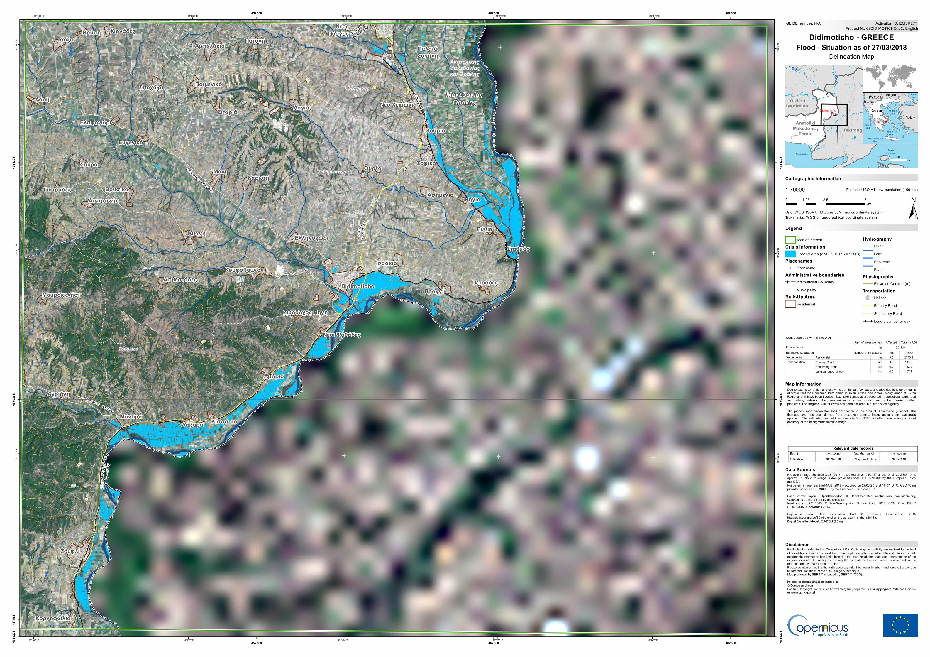
Due to extensive rainfall and snow-melt of the last few days, and also due to large amountsof water that was released from dams in rivers Evros and Ardas, many areas of EvrosRegional Unit have been flooded. Extensive damages are reported in agricultural land, roadand railway network. Many embankments across Evros river, broke, causing furtherproblems. The Regional Unit of Evros has been declared in a state of emergency .The present map shows the flood delineation in the area of Didimoticho (Greece). Thethematic layer has been derived from post-event satellite image using a semi-automaticapproach. The estimated geometric accuracy is 5 m CE90 or better, from native positionalaccuracy of the background satellite image.
Products elaborated in this Copernicus EMS Rapid Mapping activity are realized to the bestof our ability, within a very short time frame, optimising the available data and information. Allgeographic information has limitations due to scale, resolution, date and interpretation of theoriginal sources. No liability concerning the contents or the use thereof is assumed by theproducer and by the European Union.Please be aware that the thematic accuracy might be lower in urban and forested areas dueto inherent limitations of the SAR analysis techniqueMap produced by SERTIT released by SERTIT (ODO)[email protected]© European UnionFor full Copyright notice visit http://emergency.copernicus.eu/mapping/ems/cite-copernicus-ems-mapping-portal
Legend
Tick marks: WGS 84 geographical coordinate system
Product N.: 02DIDIMOTICHO, v2, EnglishActivation ID: EMSR277
Pre-event image: Sentinel 2A/B (2017) (acquired on 24/08/2017 at 09:10 UTC, GSD 10 m,approx. 0% cloud coverage in AoI) provided under COPERNICUS by the European Unionand ESA.Post-event image: Sentinel-1A/B (2018) (acquired on 27/03/2018 at 16:07 UTC, GSD 10 m)provided under COPERNICUS by the European Union and ESA.Base vector layers: OpenStreetMap © OpenStreetMap contributors, Wikimapia.org,GeoNames 2015, refined by the producer.Inset maps: JRC 2013, © EuroGeographics, Natural Earth 2012, CCM River DB ©EUJRC2007, GeoNames 2013.Population data: GHS Population Grid © European Commission, 2015http://data.europa.eu/89h/jrc-ghsl-ghs_pop_gpw4_globe_r2015a.Digital Elevation Model: EU-DEM (25 m)
0 2.5 51.25km
Didimo ticho - GREECEFlo o d - Situatio n as o f 27/03/2018
Map Info rmatio n
Delineation Map
Relevant date reco rdsEvent Situation as of27/03/2018 27/03/2018Activation Map production29/03/2018 03/05/2018
Dis claimer
Data So urces
30km
Area of InterestCris is Info rmatio n
Flooded Area (27/03/2018 16:07 UTC)Placenames
! PlacenameAdminis trative b o undaries
International Boundary! ! ! ! ! ! !! ! ! ! ! ! ! MunicipalityBuilt-Up Area
Residential
Hydro grap hyRiverLakeReservoirRiver
Phys io grap hyElevation Contour (m)
Trans p o rtatio n!(u Helipad
Primary RoadSecondary RoadLong-distance railway
Affected Total in AOIFlooded areaEstimated population 168 91552Settlements Residential ha 3.8 2075.2
Primary Road km 0.2 144.8Secondary Road km 0.0 142.5Long-distance railway km 0.0 107.7
Number of inhabitants
Transportation
Consequences within the AOIUnit of measurement
ha 2517.9


![&Z Ì ] & } u dZ /E/E'](https://static.fdocument.org/doc/165x107/629d9bc2687b3969ab0e8d75/ampz-amp-u-dz-ee.jpg)