Report on Greek Activities in relation to Systematic ...
21
Εθνική έκθεση συστηματικής παρακολούθησης του κλίματος στο πλαίσιο του Προγράμματος GCOS Report on Greek Activities in relation to Systematic Climate Observations and Global Climate Observing Systems (GCOS) According to Decisions 4/CP5 και 5/CP5 of the Conference of the Parties to the United Nations Framework Convention on Climate Change Ministry for the Environment, Physical Planning and Public Works October 2005 1
Transcript of Report on Greek Activities in relation to Systematic ...
Εθνική έκθεση συστηµατικής παρακολούθησης του κλίµατος στο πλαίσιο του Προγράµµατος GCOS
Report on Greek Activities in relation to
Systematic Climate Observations and
Global Climate Observing Systems (GCOS)
According to Decisions 4/CP5 και 5/CP5 of the Conference of the Parties to the
United Nations Framework Convention on Climate Change
Ministry for the Environment, Physical Planning and Public Works October 2005
1
Εθνική έκθεση συστηµατικής παρακολούθησης του κλίµατος στο πλαίσιο του Προγράµµατος GCOS
1. Introduction Systematic observations of the Greek environment started immediately after the Revolution of 1821 and the foundation of the modern Greek state in 1829. In 1842, the National Observatory of Athens (NOA) was established, aiming at the promotion of observations of astronomical and other parameters of natural science. The first observations taken in 1842 concerned meteorological rather than astronomical parameters. NOA collects and classifies in a systematic fashion environmental data since 1862. In an attempt to cover all areas of the physical environment, the Meteorological and Seismological Institutes were founded at NOA in 1896 and followed much later, in 1954, by the Ionospheric Institute.
The operation of the Hellenic National Meteorological Service (HNMS) comprised part of the Meteorological Institute in NOA until 1934, when it is transferred to the then Ministry of Military Affairs. In 1954, NOA starts the first program to measure solar radiation parameters, and in 1965 establishes an air pollution monitoring network for Athens, which continued operation till 1975 when it was transferred to the newly founded air pollution directorate of the Ministry for the Environment, Physical Planning and Public Works (MEPPPW).
Greece is among the countries with very high earthquake activity because of its location at the confluence of 3 tectonic major plates. Measurements of the seismic activity in the Greek territory began in 1896 by the newly founded Seismological Institute (now the Institute of Geodynamics), which continues to provide the Greek state with advice and official information on all parameters of seismic activity in the land.
To cover the needs of telecommunication, the Ionospheric Institute (now Institute for Space Applications and Remote Sensing) was founded in 1954 in NOA, aiming primarily at the study and observation of ionosphere. The institute has since expanded to include research in the magnetosphere and remote sensing techniques of the earth’s surface..
In view of the geography of Greece (18400 km of coastline, 9835 islands), and the historical preoccupation with the sea (fishing, trading and shipping), a Hydrographic Office is founded in 1905 under the General Navy Staff which begins systematic observations of currents, salinity, sea surface temperature and other sea state marine parameters. In 1920 the Hydrographic Office is upgraded to form the Hellenic Navy Hydrographic Service (HNHS), which is responsible, among others, for the establishment and operation of a network of permanent stations for measuring and collecting hydrographic, oceanographic and marine information.
In 1945, the Hydrobiological Institute is founded in the Academy of Athens, and in 1970, it forms the core of an independent Institute for Oceanography and Fishing, which in 1999 is converted to the today’s Hellenic Centre for Marine Research (HCMR).
In 2001, Greece became associated and then, in 2005, full member of the European Space Agency (ESA), participating in all the core activities of the Agency, including those of Global Monitoring of Environment and Security (GMES). The ESA activities are at present coordinated by the General Secretariat for Research and Technology (GSRT) of the Ministry of Development.
2
Εθνική έκθεση συστηµατικής παρακολούθησης του κλίµατος στο πλαίσιο του Προγράµµατος GCOS
Despite the various and multifaceted activities for the observation of the environment that take place in the country, there has not been any special administrative framework for the coordination and overall organization of the observations, except for the Geodetic and Geographical State Committee, formally supervised by the Ministry of Education and with all the institutes mentioned above plus the Army Geographic Service and representatives of the universities as members, which though does not have any mandate or the staff and resources to coordinate the activities of its members. Therefore, no coordinated GCOS action plan or for that matter any other national climatic action plan, is currently in place.
2. General approach to systematic observation The network of systematic observation of climatic parameters in Greece includes the Hellenic National Meteorological Service (HNMS), services of the Greek Armed Forces, the Ministry of Rural Development and Food, the Ministry for the Environment, Physical Planning and Public Works, as well as a number of national research centers. Furthermore, the Public Power Corporation of Greece (PPC) operates a network of meteorological stations in the vicinity of its thermal and hydro power plants and dams for electricity production. As mentioned above, these organizations operate independently resulting in possible overlaps and, mostly, in lack of a central institution for collecting and archiving data. The same goes for the quality control and availability of data, as each organization follows its own procedures and policies. Several organizations distribute the data free of charge, while others, among which the HNMS, charge for the provision of data or provide data of unknown quality. Usually though, data to be used in international projects or to meet national commitments are provided free of charge.
3. Meteorological and atmospheric observation
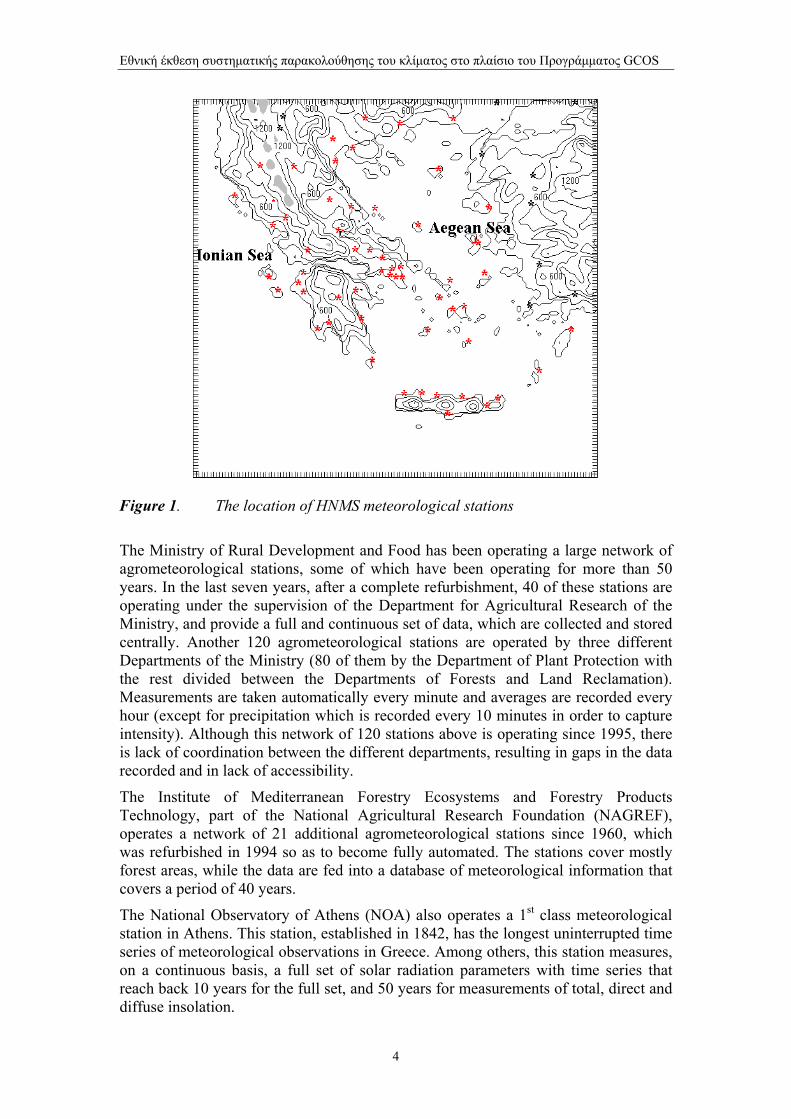
Measurements of meteorological parameters The Hellenic National Meteorological Service (HNMS) operates a network of 26 surface and 3 upper air measurement stations that provide meteorological data on a continuous basis to the international networks. In addition, it collects data from an even larger number of stations, 28 of which are registered with World Meteorological Organization (WMO) as 1st Class stations. The location of these stations is shown in Figure 1.
3
Εθνική έκθεση συστηµατικής παρακολούθησης του κλίµατος στο πλαίσιο του Προγράµµατος GCOS
Figure 1. The location of HNMS meteorological stations
The Ministry of Rural Development and Food has been operating a large network of agrometeorological stations, some of which have been operating for more than 50 years. In the last seven years, after a complete refurbishment, 40 of these stations are operating under the supervision of the Department for Agricultural Research of the Ministry, and provide a full and continuous set of data, which are collected and stored centrally. Another 120 agrometeorological stations are operated by three different Departments of the Ministry (80 of them by the Department of Plant Protection with the rest divided between the Departments of Forests and Land Reclamation). Measurements are taken automatically every minute and averages are recorded every hour (except for precipitation which is recorded every 10 minutes in order to capture intensity). Although this network of 120 stations above is operating since 1995, there is lack of coordination between the different departments, resulting in gaps in the data recorded and in lack of accessibility.
The Institute of Mediterranean Forestry Ecosystems and Forestry Products Technology, part of the National Agricultural Research Foundation (NAGREF), operates a network of 21 additional agrometeorological stations since 1960, which was refurbished in 1994 so as to become fully automated. The stations cover mostly forest areas, while the data are fed into a database of meteorological information that covers a period of 40 years.
The National Observatory of Athens (NOA) also operates a 1st class meteorological station in Athens. This station, established in 1842, has the longest uninterrupted time series of meteorological observations in Greece. Among others, this station measures, on a continuous basis, a full set of solar radiation parameters with time series that reach back 10 years for the full set, and 50 years for measurements of total, direct and diffuse insolation.
4
Εθνική έκθεση συστηµατικής παρακολούθησης του κλίµατος στο πλαίσιο του Προγράµµατος GCOS
A number of national research centers, namely the National Centre for Research in Physical Scientific Research ‘Demokritos’, the Centre of Renewable Energy Sources (CRES) and universities (National Technical University of Athens, Universities of Athens and Thessalonica), also operate meteorological stations. The time series of these stations vary in length from a few years to a few decades, and their data are widely available.
The Ministry of Rural Development and Food and the Ministry for the Environment, Physical Planning and Public Works operate a large network of rain gages and snow gages. The network consists of more than 238 rain gages and 1000 snow tables.
An effort is underway, with financing from the Ministry for the Environment, Physical Planning and Public Works to gather all available meteorological and hydrological data in one database. The project has already been launched and the technical infrastructure is now capable of receiving and storing data. The policy on availability and access to this database is not yet agreed.
Measurements of atmospheric electricity discharges
For the past two years, the National Observatory of Athens has been operating a network of stations aimed at detecting lightning strikes. The network consists of 6 recording stations, located in the UK, Denmark, Romania, Italy, Cyprus and Portugal. The lightning-strike data provide real-time information regarding the location of thunder cells and severe rainstorm activity from the coast of Florida to the Persian Gulf. This is crucial information for predicting floods and providing more accurate local forecasts. This information is provided to the meteorological community via the Internet. Recently (2003), the network, in collaboration with the US National Oceanic and Atmospheric Agency, was extended further south and east covering North Africa and India.
Meteorological RADAR
HNMS has recently (in 2004) established and is operating a network of 4 C-band meteorological radars (at Ymmetus mountain in Athens, Aigina island, Larissa, and Thessaliniki) while NOA has purchased (in 2002) and operates a mobile S-band meteorological radar.
Wind Measurements The Centre of Renewable Energy Sources (CRES) and several companies have established and operate wind measurement masts, usually of 30m height, for the collection of data to estimate wind energy potential and identify possible locations for the establishment of wind parks. The number of masts varies with the needs of possible wind park developers. Data collected, apart from the ones collected by CRES, are not available free of charge.
Ozone and UV-radiation measurements
5
Εθνική έκθεση συστηµατικής παρακολούθησης του κλίµατος στο πλαίσιο του Προγράµµατος GCOS
The Universities of Thessalonica and Athens have been monitoring the total (column) ozone amount at two locations on a continuous basis for more than 30 years. The University of Thessalonica has also maintained a background ozone measuring station at Livadi (1000 m above MSL). Furthermore, the Institute of Mediterranean Forestry Ecosystems and Forestry Products Technology of NAGREF, also measures (since April 2000) average monthly ozone concentration in 3 forest areas (in Vatada near the town of Amfilohia at 350 m height, St Nicolas in the Evrytania province at 1120 m height and on Ossa mountain at 740 m height).
The University of Thessalonica, the University of Athens, The Academy of Athens and the National Observatory of Athens measure UV (UV total, UV-B and total solar radiation components) and other relevant meteorological parameters at 7 stations some of which have been included in the GAW network (Global Atmosphere Watch).
The University of Thessalonica-Laboratory of Applied Physics operates the World Ozone Mapping Center, which utilizes measurements from the 90 stations of WMO Global Ozone System (part of GAW) and of TOMS (Total Ozone Mapping Spectrometer) to generate and archive global maps of total ozone density (http://lap.physics.auth.gr/ozonemaps/ ).
Ground level air pollutants
The Ministry for the Environment, Physical Planning and Public Works operates local networks for monitoring air pollution in the major urban areas of Greece. In the greater Athens area, the network consists of 19 stations that measure air pollutants of which 16 measure ground level ozone and 12 also measure standard meteorological parameters). The greater Thessalonica area network consists of 8 stations, 7 of which measure ozone. Eight additional stations, all of which measure ozone, are located in other cities. The data are available to the public through the National Environmental Data Center of Ministry for the Environment, Physical Planning and Public Works and through the European Environmental Agency. In addition, the Public Power Corporation of Greece operates 8 air quality stations near its power plants that monitor all standard air pollutants.
Details about the participation of Greece and provision of data in international observation programs are presented in Table 1.
Table 1: Participation in the global atmospheric observing systems
GSN GUAN GAW How many stations are the responsibility of the Party? 4 3 2 How many of those are operating now? 4 2 2 How many of those are operating to GCOS standards now? 4 2 2 How many are expected to be operating in 2008? 6 3 2 How many are providing data to international centers now? 4 2 2
6
Εθνική έκθεση συστηµατικής παρακολούθησης του κλίµατος στο πλαίσιο του Προγράµµατος GCOS
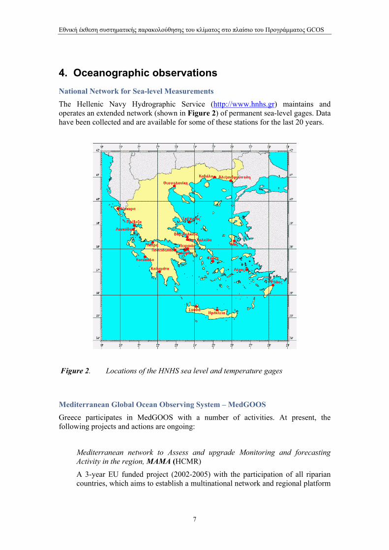
4. Oceanographic observations National Network for Sea-level Measurements The Hellenic Navy Hydrographic Service (http://www.hnhs.gr) maintains and operates an extended network (shown in Figure 2) of permanent sea-level gages. Data have been collected and are available for some of these stations for the last 20 years.
Figure 2. Locations of the HNHS sea level and temperature gages
Mediterranean Global Ocean Observing System – MedGOOS Greece participates in MedGOOS with a number of activities. At present, the following projects and actions are ongoing:
Mediterranean network to Assess and upgrade Monitoring and forecasting Activity in the region, MAMA (HCMR)
A 3-year EU funded project (2002-2005) with the participation of all riparian countries, which aims to establish a multinational network and regional platform
7
Εθνική έκθεση συστηµατικής παρακολούθησης του κλίµατος στο πλαίσιο του Προγράµµατος GCOS
for marine observations and forecasts in the Mediterranean. (http://arch.imbc.gr/mama/index_gr.html)
Mediterranean multi-sensor moored Array buoy system, M3A (HCMR)
A pilot system for the automated monitoring of a complete set of physical parameters, including temperature, salinity and currents, together with relevant biochemical and optical measurements, which was successfully deployed in the Cretan Sea in the frame of the Mediterranean Forecasting Systems Towards Environmental Predictions (MFSTEP) program, which was a continuation of the Mediterranean Forecasting System Pilot Project (MFSPP). (http://www.medgoos.net/).
Voluntary observing ship - VOS
HCMR and HNMS have been activated in the past (2001-2003) the voluntary observing ship project VOS of MFSTEP, using 10 ships in a continuous basis and 8 more as auxiliary. There are plans for the continuation of the project in the near future.
Hellenic National Oceanographic Data Center– HNODC
A database for the existing marine environmental data has been created by HCMR, in the frame of the European Directory of Marine Environmental Data (EDMEP) project. The information collected derives from all the institutions of marine research, such as HCMR, the Institute of Marine Biology in Crete (as of 1999 a part of HCMR) and the public oil company for hydrocarbon research and exploitation.
HNODC contributes data and information to the Mediterranean Hydrographic Atlas (MEDATLAS) project for the development of inventories of vertical temperature/salinity profiles (Τ/S) collected in the Eastern Mediterranean Sea, carries out quality checks on the T/S profiles and participates in the synthetic work leading to the construction of the climatology of the Eastern Mediterranean Sea.
Marine Monitoring System – POSEIDON
HCMR has put in place and operates in the last few years a network of 9 observation buoys to record the physical, biological and chemical parameters in the Greek seas. The data collected are being processes and archived and utilized for forecast purposes of the state of the Greek seas by a dedicated unit providing information on-line to the shipping community.
Oceanographic Ships HNHS owns and operates 4 ships, 3 of which are fully equipped for oceanographic research and observations.
HCMR operates 4 ships for marine research, including a bathyscaphe that is capable of reaching 610 m under the sea surface.
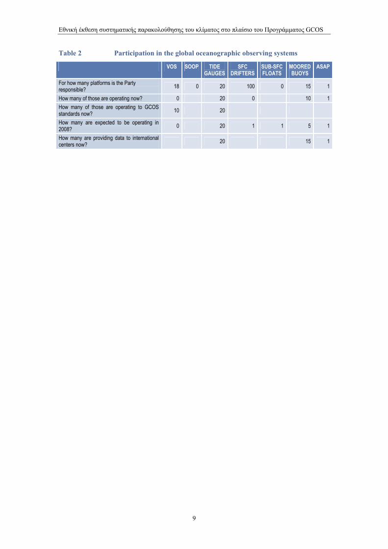
The participation of the country in international observation programs is presented in tabular form in Table 2.
8
Εθνική έκθεση συστηµατικής παρακολούθησης του κλίµατος στο πλαίσιο του Προγράµµατος GCOS
Table 2 Participation in the global oceanographic observing systems
VOS SOOP TIDE GAUGES
SFC DRIFTERS
SUB-SFC FLOATS
MOORED BUOYS
ASAP
For how many platforms is the Party responsible? 18 0 20 100 0 15 1
How many of those are operating now? 0 20 0 10 1 How many of those are operating to GCOS standards now? 10 20
How many are expected to be operating in 2008? 0 20 1 1 5 1
How many are providing data to international centers now? 20 15 1
9
Εθνική έκθεση συστηµατικής παρακολούθησης του κλίµατος στο πλαίσιο του Προγράµµατος GCOS
5. Terrestrial Observations
Observation System on quantity/quality of surface water
The Ministry of Rural Development and Food and the Ministry for the Environment, Physical Planning and Public Works, PPC and NAGREF operate an extended network of rainfall and snowfall gages. The network consists of more than 238 rain gages and more than 1000 tables to measure the height of snow. Furthermore, the Institute of Geology and Mineral Exploration (IGME) operates a large network of surface and ground water measurements.
Among these stations, only 47 hydrometric stations, supervised by PPC, meet international specifications so as to be able to contribute quality controlled data to the corresponding databases. The Ministry of Rural Development and Food also operates 220 stations for the measurement of surface water quantities. Of those, 120 (90 of which for river-stream flows and 30 for river water quality) operate during the whole year producing monthly measurements, and the rest operate only during the irrigation period.
Finally, groundwater quality and quantity measurements are carried out by the Ministry of Rural Development and Food (250 stations mostly in rural areas, such as Thessalia, and by IGME (approximately 450 stations, 380 of which are placed in wells and 70 in springs). Several stations among them measure parameters related to water pollution such as ammonia, nitric and pH, mostly caused by agricultural activities.
Forest ecosystem health observation
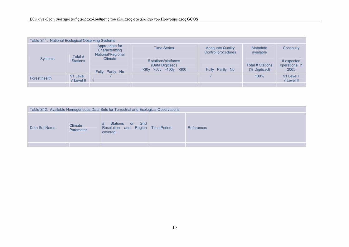
In the scope of the country’s participation in the International Co-operative Programme on Assessment and Monitoring of Air Pollution Effects on Forests, (ICP Forests) and the European Union Scheme for the Protection of Forests against Atmospheric Pollution, the Institute of Mediterranean Forestry Ecosystems and Forestry Products Technology of NAGREF has established in 1988 and operates since 91 observation stations of Level I and 7 of Level II. Of the 91 Level I stations, 75 have been placed in high canopy forests and in 16 in maquis areas to provide information on tree conditions. The Level II stations have been placed (4 in 1994 and 3 in 2004) in forest ecosystems of typical terrestrial and geological types aiming at the study of the relations between the ecological and physical parameters (meteorological characteristics, vegetation, soil, plant nutrition and air pollution) as they affect forest development.
CO2 flux measurements A station for CO2 vertical flux measurements has been established and operated for a number of years in Kalamata by NAGREF, in the frame of the research project MEDFLUX of the European Commission.
10
Εθνική έκθεση συστηµατικής παρακολούθησης του κλίµατος στο πλαίσιο του Προγράµµατος GCOS
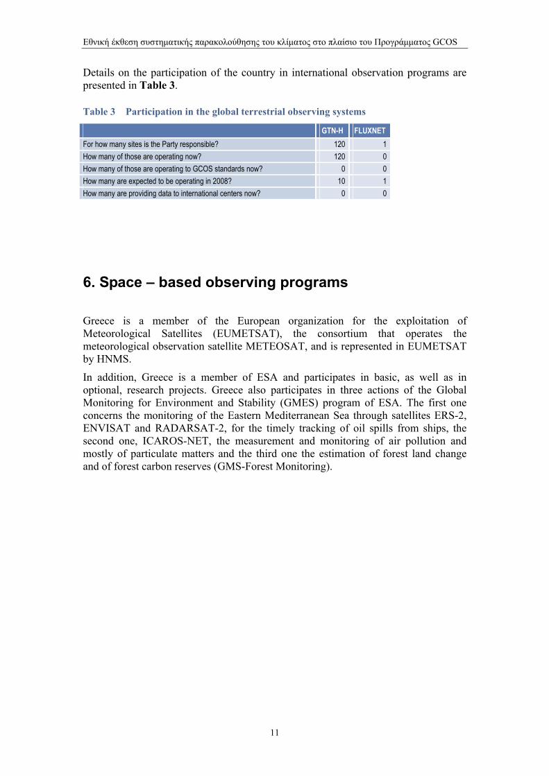
Details on the participation of the country in international observation programs are presented in Table 3.
Table 3 Participation in the global terrestrial observing systems
GTN-Η FLUXNET For how many sites is the Party responsible? 120 1 How many of those are operating now? 120 0 How many of those are operating to GCOS standards now? 0 0 How many are expected to be operating in 2008? 10 1 How many are providing data to international centers now? 0 0
6. Space – based observing programs
Greece is a member of the European organization for the exploitation of Meteorological Satellites (EUMETSAT), the consortium that operates the meteorological observation satellite METEOSAT, and is represented in EUMETSAT by HNMS.
In addition, Greece is a member of ESA and participates in basic, as well as in optional, research projects. Greece also participates in three actions of the Global Monitoring for Environment and Stability (GMES) program of ESA. The first one concerns the monitoring of the Eastern Mediterranean Sea through satellites ERS-2, ENVISAT and RADARSAT-2, for the timely tracking of oil spills from ships, the second one, ICAROS-NET, the measurement and monitoring of air pollution and mostly of particulate matters and the third one the estimation of forest land change and of forest carbon reserves (GMS-Forest Monitoring).
11
Εθνική έκθεση συστηµατικής παρακολούθησης του κλίµατος στο πλαίσιο του Προγράµµατος GCOS
ANNEX Ι Additional Tables
12

Εθνική έκθεση συστηµατικής παρακολούθησης του κλίµατος στο πλαίσιο του Προγράµµατος GCOS
Table S1. Atmospheric Observing Systems at the Land Surface (Surface Meteorological Observation)
Systems Climate Parameters Total # Stations
Appropriate for Characterizing
National Climate
Fully Partly No
Time Series
# stations/platforms (Data Digitized)
>5y >50y >100y
Adequate Quality Control
Procedures
Fully Partly No
Metadata available
Total # Stations
(% Digitized)
Continuity
# expected operational in
2008
Reference Climatological Stations
Press Prec, Temp, humidity, Wind Speed, Radiation (watt/m2)
37
√
√
√
70%
7
Ordinary Hydro meteorological Stations
Precip, snow fall, water balance
251
√
√
√
30%
all
Stations Reporting Internationally
Press,Temp, prec humidity, Wind Speed, Radiation (watt/m2)
28 WMO
√
√
√
100%
all
Rainfall Network (in addition to Clim Stations)
Precipitation and snowfall
238
1000
√
√
√
30%
all
Stations of rural-meteorological observation
Prec, Temp, humidity, Wind Speed, Radiation (watt/m2)
~160
√
√
√
30%
all
Other Climatological Stations
Precipitable water
4 Radar C-Band 1 Radar S-Band
√
sporadic
√
10%
8
13
Εθνική έκθεση συστηµατικής παρακολούθησης του κλίµατος στο πλαίσιο του Προγράµµατος GCOS
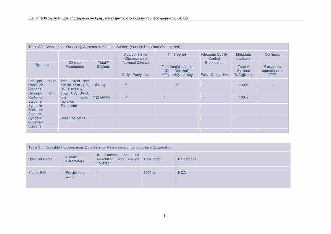
Table S2. Atmospheric Observing Systems at the Land Surface (Surface Radiation Observation)
Systems Climate Parameters
Total # Stations
Appropriate for Characterizing
National Climate
Fully Partly No
Time Series
# stations/platforms (Data Digitized)
>30y >50y >100y
Adequate Quality Control
Procedures
Fully Partly No
Metadata available
Total # Stations
(% Digitized)
Continuity
# expected operational in
2008
Principal Clim Radiation Stations
Total direct and diffuse solar, UV, UV-B, net flux
1(NOA)
√
√
√
100%
1
Ordinary Clim Radiation Stations
Total UV, UV-B, total solar radiation
7 (2 GAW)
√
√
√
100%
Synoptic Radiation Stations
Total solar
Synoptic Sunshine Stations
Sunshine hours
Table S3. Available Homogeneous Data Sets for Meteorological Land Surface Observation
Data Set Name Climate Parameters
# Stations or Grid Resolution and Region covered
Time Period References
Sferics RHI
Precipitable water
1
2004 on
NOA
14
Εθνική έκθεση συστηµατικής παρακολούθησης του κλίµατος στο πλαίσιο του Προγράµµατος GCOS
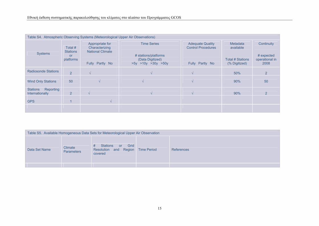
Table S4. Atmospheric Observing Systems (Meteorological Upper Air Observations)
Systems
Total # Stations
or platforms
Appropriate for Characterizing
National Climate
Fully Partly No
Time Series
# stations/platforms (Data Digitized)
>5y >10y >30y >50y
Adequate Quality Control Procedures
Fully Partly No
Metadata available
Total # Stations (% Digitized)
Continuity
# expected operational in
2008
Radiosonde Stations 2
√
√
√
50%
2
Wind Only Stations
50
√
√
√
90%
50
Stations Reporting Internationally
2
√
√
√
90%
2
GPS
1
√
Table S5. Available Homogeneous Data Sets for Meteorological Upper Air Observation
Data Set Name Climate Parameters
# Stations or Grid Resolution and Region covered
Time Period References
15
Εθνική έκθεση συστηµατικής παρακολούθησης του κλίµατος στο πλαίσιο του Προγράµµατος GCOS
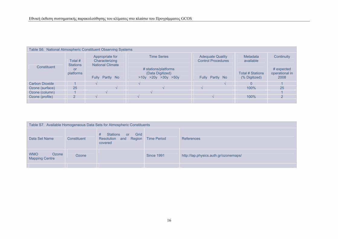
Table S6. National Atmospheric Constituent Observing Systems
Constituent
Total # Stations
or platforms
Appropriate for Characterizing
National Climate
Fully Partly No
Time Series
# stations/platforms (Data Digitized)
>10y >20y >30y >50y
Adequate Quality Control Procedures
Fully Partly No
Metadata available
Total # Stations (% Digitized)
Continuity
# expected operational in
2008
Carbon Dioxide 1 √ √ √ 0 1 Ozone (surface) 25 √ √ √ 100% 25 Ozone (column) 1 √ √ 1 Ozone (profile) 2 √ √ √ 100% 2
Table S7. Available Homogeneous Data Sets for Atmospheric Constituents
Data Set Name Constituent # Stations or Grid Resolution and Region covered
Time Period References
WMO Ozone Mapping Centre
Ozone
Since 1991
http://lap.physics.auth.gr/ozonemaps/
16
Εθνική έκθεση συστηµατικής παρακολούθησης του κλίµατος στο πλαίσιο του Προγράµµατος GCOS
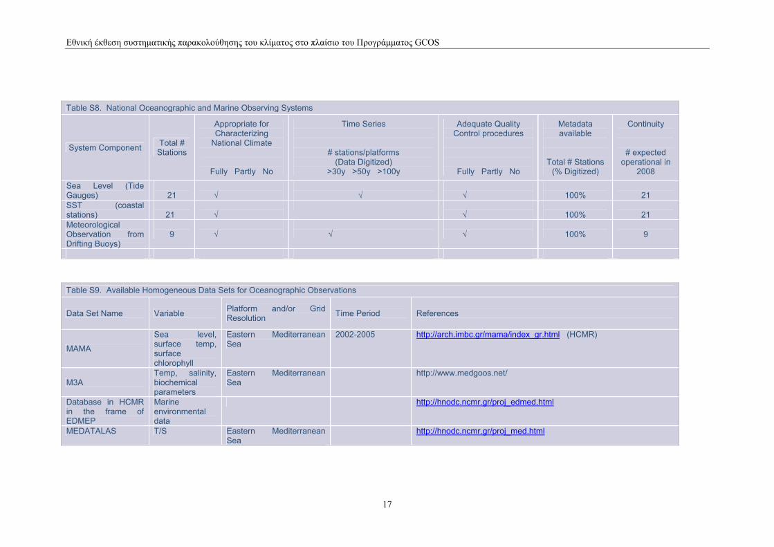
Table S8. National Oceanographic and Marine Observing Systems
System Component Total # Stations
Appropriate for Characterizing
National Climate
Fully Partly No
Time Series
# stations/platforms (Data Digitized)
>30y >50y >100y
Adequate Quality Control procedures
Fully Partly No
Metadata available
Total # Stations (% Digitized)
Continuity
# expected operational in
2008
Sea Level (Tide Gauges)
21
√
√
√
100%
21
SST (coastal stations)
21
√
√
100%
21
Meteorological Observation from Drifting Buoys)
9
√
√
√
100%
9
Table S9. Available Homogeneous Data Sets for Oceanographic Observations
Data Set Name Variable Platform and/or Grid Resolution Time Period References
ΜΑΜΑ
Sea level, surface temp, surface chlorophyll
Eastern Mediterranean Sea
2002-2005 http://arch.imbc.gr/mama/index_gr.html (HCMR)
M3A Temp, salinity, biochemical parameters
Eastern Mediterranean Sea
http://www.medgoos.net/
Database in HCMR in the frame of EDMEP
Marine environmental data
http://hnodc.ncmr.gr/proj_edmed.html
MEDATALAS T/S Eastern Mediterranean Sea
http://hnodc.ncmr.gr/proj_med.html
17
Εθνική έκθεση συστηµατικής παρακολούθησης του κλίµατος στο πλαίσιο του Προγράµµατος GCOS
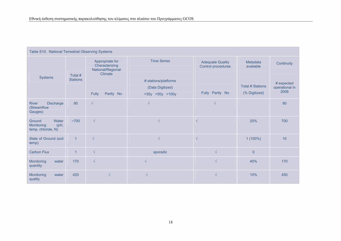
Table S10. National Terrestrial Observing Systems
Systems Total # Stations
Appropriate for Characterizing
National/Regional Climate
Fully Partly No
Time Series
# stations/platforms
(Data Digitized)
>30y >50y >100y
Adequate Quality Control procedures
Fully Partly No
Metadata available
Total # Stations
(% Digitized)
Continuity
# expected operational in
2008
River Discharge (Streamflow Gauges)
90 √ √ √ 90
Ground Water Monitoring (pH, temp, chloride, N)
~700 √ √ √ 20% 700
State of Ground (soil temp)
1 √ √ √ 1 (100%) 10
Carbon Flux 1 √ sporadic √ 0
Monitoring water quantity
170 √ √ √ 40% 170
Monitoring water quality
420 √ √ √ 10% 450
18
Εθνική έκθεση συστηµατικής παρακολούθησης του κλίµατος στο πλαίσιο του Προγράµµατος GCOS
Table S11. National Ecological Observing Systems
Systems Total # Stations
Appropriate for Characterizing
National/Regional Climate
Fully Partly No
Time Series
# stations/platforms (Data Digitized)
>30y >50y >100y >300
Adequate Quality Control procedures
Fully Partly No
Metadata available
Total # Stations (% Digitized)
Continuity
# expected operational in
2005
Forest health 91 Level I 7 Level II
√ √
√ 100% 91 Level I 7 Level II
Table S12. Available Homogeneous Data Sets for Terrestrial and Ecological Observations
Data Set Name Climate Parameter
# Stations or Grid Resolution and Region covered
Time Period References
19
Εθνική έκθεση συστηµατικής παρακολούθησης του κλίµατος στο πλαίσιο του Προγράµµατος GCOS
ANNEX ΙΙ Acronyms
20
Εθνική έκθεση συστηµατικής παρακολούθησης του κλίµατος στο πλαίσιο του Προγράµµατος GCOS
21
ASAP Automated Shipboard Aerological Programme CLIPS Climate Information and Prediction Services CRES Center of Renewable Energy Sources EDMEP European Directory of Marine Environmental Data ECMWF European Centre for Medium-range Weather Forecast EUMETSAT EUropean Organization for the exploitation of METeorological SATellites ESA European Space Agency FLUXNET Global Terrestrial Network – Carbon FRST Foundation for Research, Science and Technology GAW Global Atmosphere Watch of WMO GCOS Global Climate Observing System GMES Global Monitoring of Environment and Security GMS Geostationary Meteorological Satellite GOOS Global Ocean Observing System GSN GCOS Surface Network GSRT General Secretariat for Research and Technology GTN-G Global Terrestrial Network – Glaciers GTN-P Global Terrestrial Network – Permafrost GTOS Global Terrestrial Observation System GUAN GCOS Upper Air Network HCMR Hellenic Centre for Marine Research HNHS Hellenic Navy Hydrographic Service HNMS Hellenic National Meteorological Service HNODC Hellenic National Oceanographic Data Center IGME Institute of Geology and Mineral Exploration IOC Intergovernmental Oceanographic Commission of UNESCO LCDB Land Cover Data Base LTER Long Term Ecological Research MAMA Mediterranean network to Assess and upgrade Monitoring and forecasting Activity MEDATLAS Mediterranean Hydrographic Atlas MedGOOS Ocean Observing System for the Mediterranean MEPPPW Ministry for the Environment, Physical Planning and Public Works MFSPP Mediterranean Forecasting System Pilot Project MFSTEP Mediterranean Forecasting Systems Towards Environmental Predictions NAGREF National Agricultural Research Foundation NOA National Observatory of Athens ΝΟΑΑ National Oceanographic and Atmospheric Agency (USA) NSA NIWA SST Archive NVS National Vegetation System PPC Public Power Corporation SFC Surface SOOP Ship of Opportunity Programme SST Sea Surface Temperature Sub-SFC Sub-surface TIROS Television Infrared Observation Satellite TOMS Total Ozone Mapping Spectrometer UNEP United Nations Environment Programme UNESCO United Nations Educational, Scientific and Cultural Organization VOS Volunteer Observing Ship WCRP World Climate Research Programme WHYCOS World Hydrological Cycle Observing System WMO World Meteorological Organization WWW World Weather Watch of WMO