PRESERVING THE NON-PRESERVABLE GEOHERITAGE OF THE …
10
255 Δελτίο της Ελληνικής Γεωλογικής Εταιρίας, τόμος L, σελ. 255-264 Πρακτικά 14 ου Διεθνούς Συνεδρίου, Θεσσαλονίκη, Μάιος 2016 Bulletin of the Geological Society of Greece, vol. L, p. 255-264 Proceedings of the 14 th International Congress, Thessaloniki, May 2016 PRESERVING THE NON-PRESERVABLE GEOHERITAGE OF THE ALIAKMON RIVER: A CASE STUDY IN GEO- EDUCATION LEADING TO CUTTING-EDGE SCIENCE Rassios A. 1 , Grieco G. 2 , Batsi A. 3 , Myhill R. 4 and Ghikas D. 5 1 Institute of Geology and Mineral Exploration, Regional Office of West Macedonia, Lefkovrisi - Kozani, 50100 Greece, [email protected] 2 Scienze della Terra "A. Desio," Università degli Studi di Milano, Via Botticelli, 23 Milano, Italy, [email protected] 3 Aim. Veaki 12, Kozani 50131, Greece, [email protected] 4 Bayerisches Geoinstitut, Universitätsstraße 30, 95447 Bayreuth myhill, [email protected] 5 Geopark Grevena-Tethys, TEI Grevena 51100, Greece, [email protected] Abstract The initial documentation of an ophiolite as oceanic lithosphere and the significance of an ophiolite’s basal sole in its emplacement were based on the research of E. Moores (1969) and J. Zimmerman (1968) at the Vourinos Ophiolite, Greece: their work became a lynch-pin in the establishment of plate tectonic theory. Key localities of their research were located along the Aliakmon River Valley between Ilariona Monastery and the village of Panayia. This same area has since been flooded (2012) with the construction of a new hydroelectric reservoir. There was no option for “saving” these sites of the birth of plate tectonic theory: what could be done to preserve their geoheritage? Between 2005 and 2008, the Institute of Geology and Mineral Exploration, with funding provided from the Public Power Corporation, sponsored geo-education to provide a “last chance” of geologic documentation of the Aliakmon Valley. In a three year period, over 60 international student and professorial-level researchers participated in the project. 37 Senior Theses were produced and 6 masters’ dissertations. The greatest achievement of the program was the revitalization of the Aliakmon data base within current, cutting-edge scientific models. Keywords: Geoheritage, Geoeducation, Aliakmon, Geopark. Περίληψη Η αρχική περιγραφή των οφιολίθων σαν ωκεάνια λιθόσφαιρα και η σημασία της μεταμορφωμένης σόλας, βασίστηκαν σε έρευνα των Ε. Moores (1969) και J. Zimmerman (1968) στον Βούρινο, Δυτ. Μακεδονία: η δουλειά τους αποτέλεσε βασικό ρόλο στη δημιουργία της θεωρίας των τεκτονικών πλακών. Θέσεις «κλειδιά» της έρευνάς τους βρίσκονταν κατά μήκος της κοιλάδας του ποταμού Αλιάκμονα, μεταξύ της Μονής Ιλαρίωνα και του οικισμού της Παναγίας. Η περιοχή αυτή έχει πλημμυρίσει (2012) από τα νερά του ταμιευτήρα του φράγματος Ιλαρίωνα. Για τις σημαντικές επιστημονικές θέσεις αυτές, δεν υπήρχε καμία δυνατότητα «προστασίας», άρα τι θα μπορούσε να γίνει για να διατηρηθεί η γεωκληρονομιά τους; Μεταξύ του 2005 και του
Transcript of PRESERVING THE NON-PRESERVABLE GEOHERITAGE OF THE …
255
Δελτίο της Ελληνικής Γεωλογικής Εταιρίας, τόμος L, σελ. 255-264 Πρακτικά 14ου Διεθνούς Συνεδρίου, Θεσσαλονίκη, Μάιος 2016
Bulletin of the Geological Society of Greece, vol. L, p. 255-264 Proceedings of the 14th International Congress, Thessaloniki, May 2016
PRESERVING THE NON-PRESERVABLE GEOHERITAGE
OF THE ALIAKMON RIVER: A CASE STUDY IN GEO-
EDUCATION LEADING TO CUTTING-EDGE SCIENCE
Rassios A.1, Grieco G.2, Batsi A.3, Myhill R.4 and Ghikas D.5
1Institute of Geology and Mineral Exploration, Regional Office of West Macedonia, Lefkovrisi -
Kozani, 50100 Greece, [email protected]
2Scienze della Terra "A. Desio," Università degli Studi di Milano, Via Botticelli, 23 Milano, Italy,
3Aim. Veaki 12, Kozani 50131, Greece, [email protected]
4Bayerisches Geoinstitut, Universitätsstraße 30, 95447 Bayreuth myhill, [email protected]
5Geopark Grevena-Tethys, TEI Grevena 51100, Greece, [email protected]
Abstract
The initial documentation of an ophiolite as oceanic lithosphere and the significance
of an ophiolite’s basal sole in its emplacement were based on the research of E.
Moores (1969) and J. Zimmerman (1968) at the Vourinos Ophiolite, Greece: their
work became a lynch-pin in the establishment of plate tectonic theory. Key localities
of their research were located along the Aliakmon River Valley between Ilariona
Monastery and the village of Panayia. This same area has since been flooded (2012)
with the construction of a new hydroelectric reservoir. There was no option for
“saving” these sites of the birth of plate tectonic theory: what could be done to
preserve their geoheritage? Between 2005 and 2008, the Institute of Geology and
Mineral Exploration, with funding provided from the Public Power Corporation,
sponsored geo-education to provide a “last chance” of geologic documentation of the
Aliakmon Valley. In a three year period, over 60 international student and
professorial-level researchers participated in the project. 37 Senior Theses were
produced and 6 masters’ dissertations. The greatest achievement of the program was
the revitalization of the Aliakmon data base within current, cutting-edge scientific
models.
Keywords: Geoheritage, Geoeducation, Aliakmon, Geopark.
Περίληψη
Η αρχική περιγραφή των οφιολίθων σαν ωκεάνια λιθόσφαιρα και η σημασία της
μεταμορφωμένης σόλας, βασίστηκαν σε έρευνα των Ε. Moores (1969) και J.
Zimmerman (1968) στον Βούρινο, Δυτ. Μακεδονία: η δουλειά τους αποτέλεσε βασικό
ρόλο στη δημιουργία της θεωρίας των τεκτονικών πλακών. Θέσεις «κλειδιά» της
έρευνάς τους βρίσκονταν κατά μήκος της κοιλάδας του ποταμού Αλιάκμονα, μεταξύ της
Μονής Ιλαρίωνα και του οικισμού της Παναγίας. Η περιοχή αυτή έχει πλημμυρίσει
(2012) από τα νερά του ταμιευτήρα του φράγματος Ιλαρίωνα. Για τις σημαντικές
επιστημονικές θέσεις αυτές, δεν υπήρχε καμία δυνατότητα «προστασίας», άρα τι θα
μπορούσε να γίνει για να διατηρηθεί η γεωκληρονομιά τους; Μεταξύ του 2005 και του
256
2008, το Ινστιτούτο Γεωλογικών και Μεταλλευτικών Ερευνών, με χρηματοδότηση της
Δημόσιας Επιχείρησης Ηλεκτρισμού (ΔΕΗ), υλοποιήθηκε μία γεω-εκπαίδευση ώστε να
δώσει μια "τελευταία ευκαιρία" στη γεωλογική τεκμηρίωση της κοιλάδας του
Αλιάκμονα. Σε διάστημα τριών ετών, πάνω από 60 διεθνείς ερευνητές φοιτητές και
υψηλού επιπέδου καθηγητές συμμετείχαν στο πρόγραμμα. Εκπονήθηκαν 37 Πτυχιακές
εργασίες και 6 Μεταπτυχιακές Διατριβές. Το μεγαλύτερο επίτευγμα του προγράμματος,
ήταν η ανανέωση της βάσης δεδομένων του Αλιάκμονα, στο πλαίσιο των υφιστάμενων,
επιστημονικών μοντέλων αιχμής.
Λέξεις κλειδιά: Γεω-εκπαίδευση, Γεωκληρονομιά, Αλιάκμονα, Γεωπάρκο.
1. Introduction
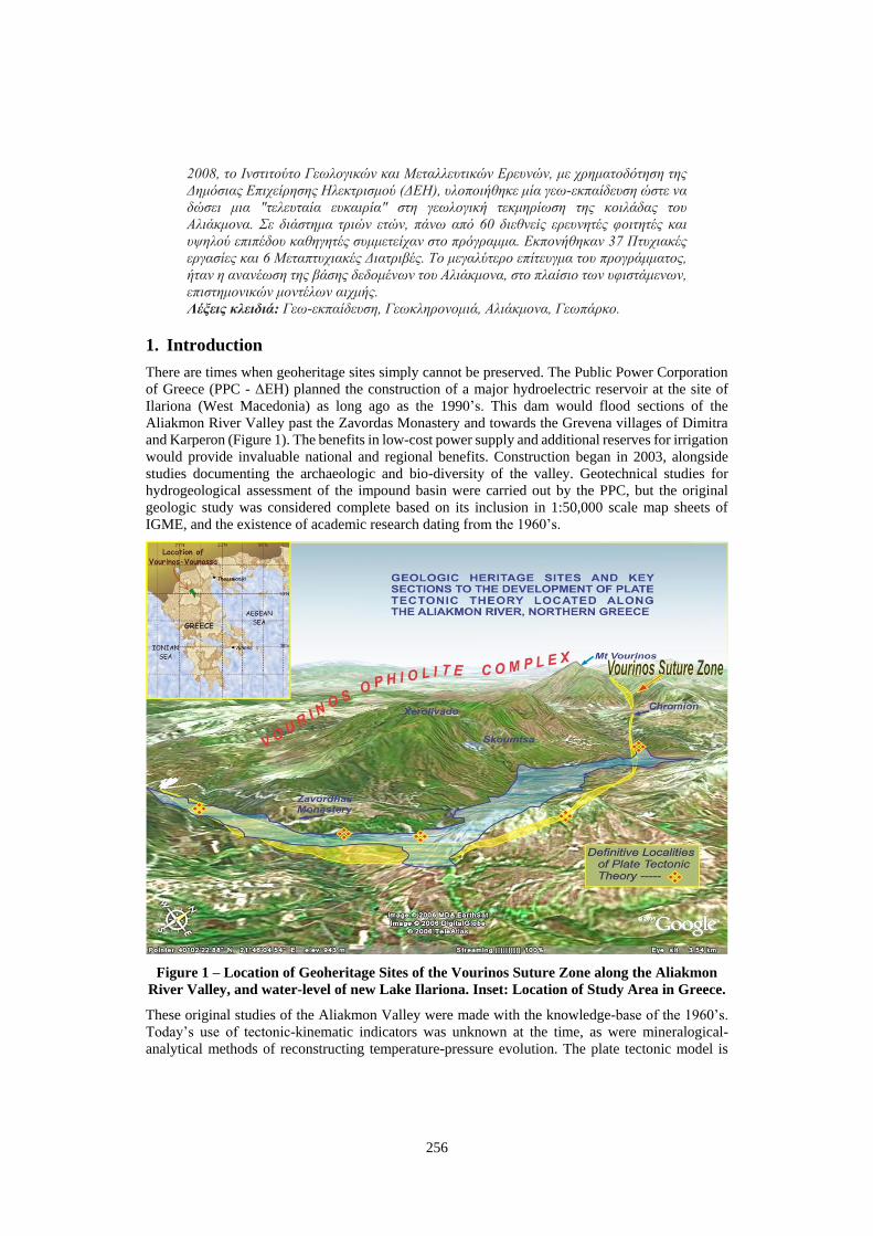
There are times when geoheritage sites simply cannot be preserved. The Public Power Corporation
of Greece (PPC - ΔΕΗ) planned the construction of a major hydroelectric reservoir at the site of
Ilariona (West Macedonia) as long ago as the 1990’s. This dam would flood sections of the
Aliakmon River Valley past the Zavordas Monastery and towards the Grevena villages of Dimitra
and Karperon (Figure 1). The benefits in low-cost power supply and additional reserves for irrigation
would provide invaluable national and regional benefits. Construction began in 2003, alongside
studies documenting the archaeologic and bio-diversity of the valley. Geotechnical studies for
hydrogeological assessment of the impound basin were carried out by the PPC, but the original
geologic study was considered complete based on its inclusion in 1:50,000 scale map sheets of
IGME, and the existence of academic research dating from the 1960’s.
Figure 1 – Location of Geoheritage Sites of the Vourinos Suture Zone along the Aliakmon
River Valley, and water-level of new Lake Ilariona. Inset: Location of Study Area in Greece.
These original studies of the Aliakmon Valley were made with the knowledge-base of the 1960’s.
Today’s use of tectonic-kinematic indicators was unknown at the time, as were mineralogical-
analytical methods of reconstructing temperature-pressure evolution. The plate tectonic model is
257
now a geological paradigm, based in part on these original studies of the Aliakmon Valley. We
approached the PPC with the proposal to review the valley’s tectonic sites using a contemporary
science base, and to document its geo-historic features with more modern mapping (GIS-based) and
photographic techniques. We were aware that this would be the last opportunity to survey these
critical localities. What we did not expect were results that added to a “cutting edge” scientific view
of the tectonic processes of ophiolitic emplacement and important new descriptions leading to the
interpretation of the region as the “Birth of Europe”.
2. Geoheritage of the Aliakmon Valley
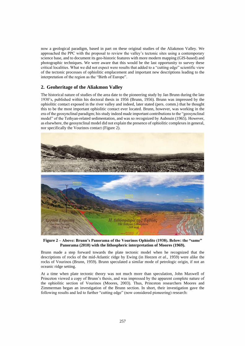
The historical nature of studies of the area date to the pioneering study by Jan Brunn during the late
1930’s, published within his doctoral thesis in 1956 (Brunn, 1956). Brunn was impressed by the
ophiolitic contact exposed in the river valley and indeed, later stated (pers. comm.) that he thought
this to be the most important ophiolitic contact ever located. Brunn, however, was working in the
era of the geosynclinal paradigm; his study indeed made important contributions to the “geosynclinal
model” of the Tethyan-related sedimentation, and was so recognized by Aubouin (1965). However,
as elsewhere, the geosynclinal model did not explain the presence of ophiolitic complexes in general,
nor specifically the Vourinos contact (Figure 2).
Figure 2 – Above: Brunn’s Panorama of the Vourinos Ophiolite (1938). Below: the “same”
Panorama (2010) with the lithospheric interpretation of Moores (1969).
Brunn made a step forward towards the plate tectonic model when he recognized that the
descriptions of rocks of the mid-Atlantic ridge by Ewing (in Heezen et al., 1959) were alike the
rocks of Vourinos (Brunn, 1959). Brunn speculated a similar mode of petrologic origin, if not an
oceanic ridge setting.
At a time when plate tectonic theory was not much more than speculation, John Maxwell of
Princeton viewed a copy of Brunn’s thesis, and was impressed by the apparent complete nature of
the ophiolitic section of Vourinos (Moores, 2003). Thus, Princeton researchers Moores and
Zimmerman began an investigation of the Brunn section. In short, their investigation gave the
following results and led to further “cutting edge” (now considered pioneering) research:
258
Moores described and documented Vourinos as a potential oceanic lithospheric analogy
with an intact internal section extending from earth’s upper mantle through an oceanic crust
to sub-sea sedimentary deposits (Moores, 1969).
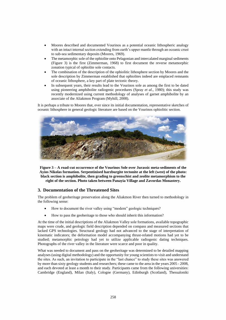
The metamorphic sole of the ophiolite onto Pelagonian and intercalated marginal sediments
(Figure 3) is the first (Zimmerman, 1968) to first document the reverse metamorphic
zonation typical of ophiolite sole contacts.
The combination of the description of the ophiolitic lithosphere section by Moores and the
sole description by Zimmerman established that ophiolites indeed are emplaced remnants
of oceanic lithosphere, a key part of plate tectonic theory.
In subsequent years, their results lead to the Vourinos sole as among the first to be dated
using pioneering amphibolite radiogenic procedures (Spray et al., 1980); this study was
recently modernized using current methodology of analyses of garnet amphibolite by an
associate of the Aliakmon Program (Myhill, 2008).
It is perhaps a tribute to Moores that, ever since its initial documentation, representative sketches of
oceanic lithosphere in general geologic literature are based on the Vourinos ophiolitic section.
Figure 3 – A road-cut occurrence of the Vourinos Sole over Jurassic meta-sediments of the
Ayios Nikolas formation. Serpentinised harzburgite tectonite at the left (west) of the photo:
black section is amphibolite, then grading to greenschist and zeolite metamorphism to the
right of the section. Photo taken between Panayia Village and Zavordas Monastery.
3. Documentation of the Threatened Sites
The problem of geoheritage preservation along the Aliakmon River then turned to methodology in
the following sense:
How to document the river valley using “modern” geologic techniques?
How to pass the geoheritage to those who should inherit this information?
At the time of the initial descriptions of the Aliakmon Valley sole formations, available topographic
maps were crude, and geologic field description depended on compass and measured sections that
lacked GPS technologies. Structural geology had not advanced to the stage of interpretation of
kinematic indicators; the deformation model accompanying thrust-related motions had yet to be
studied; metamorphic petrology had yet to utilize applicable radiogenic dating techniques.
Photographs of the river valley in the literature were scarce and poor in quality.
What was needed to document and pass on the geoheritage was determined to be detailed mapping
analyses (using digital methodology) and the opportunity for young scientists to visit and understand
the sites. As such, an invitation to participate in the “last chance” to study these sites was answered
by more than sixty geology students and researchers; these came to the area in the years 2005 - 2008,
and each devoted at least a month to their study. Participants came from the following universities:
Cambridge (England), Milan (Italy), Cologne (Germany), Edinburgh (Scotland), Thessaloniki
259
(Greece), Athens (Greece), Miami (Ohio - USA), Beloit (Wisconsin-USA), Utrecht (Holland),
Cinncinnati - USA, Colgate - USA, and several others with short visits. Each participant was given:
Access to otherwise inaccessible original studies of the valley including those of Brunn,
Moores, and Zimmerman, as well as to European-Greek studies (Wright, 1986 among
others) conducted within I.G.M.E.
1:5000 scale topographic maps of the area
Access to existing microscopic petrographic collections
A two-day preliminary training field trip within the Vourinos Ophiolite and Vounassa
Metamorphic Section surveying petrologic and tectonic diversity.
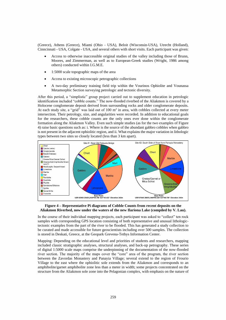
After this period, a “simplistic” group project carried out to supplement education in petrologic
identification included “cobble counts.” The now-flooded riverbed of the Aliakmon is covered by a
Holocene conglomerate deposit derived from surrounding rocks and older conglomerate deposits.
At each study site, a “grid” was laid out of 100 m2 in area, with cobbles collected at every meter
intersection. Their petrology, size, and angularities were recorded. In addition to educational goals
for the researchers, these cobble counts are the only ones ever done within the conglomerate
formation along the Aliakmon Valley. Even such simple studies (as for the two examples of Figure
4) raise basic questions such as: i. Where is the source of the abundant gabbro cobbles when gabbro
is not present in the adjacent ophiolitic region, and ii. What explains the major variation in lithologic
types between two sites so closely located (less than 3 km apart).
Figure 4 – Representative Pi diagrams of Cobble Counts from recent deposits on the
Aliakmon Riverbed, now under the waters of the new Ilariona Lake (compiled by V. Lau).
In the course of their individual mapping projects, each participant was asked to “collect” ten rock
samples with corresponding GPS location consisting of both representative and unusual lithologic-
tectonic examples from the part of the river to be flooded. This has generated a study collection to
be curated and made accessible for future geoscientists including over 500 samples. The collection
is stored in Deskati, Greece, at the Geopark Grevena-Tethys Information Center.
Mapping: Depending on the educational level and priorities of students and researchers, mapping
included classic stratigraphic analyses, structural analyses, and back-up petrography. These series
of digital 1:5000 scale maps comprise the underpinning of the documentation of the now-flooded
river section. The majority of the maps cover the “core” area of the program, the river section
between the Zavordas Monastery and Panayia Village; several extend to the region of Frourio
Village to the east where the ophiolitic sole extends from the Aliakmon and corresponds to an
amphibolite/garnet amphibolite zone less than a meter in width; some projects concentrated on the
structure from the Aliakmon sole zone into the Pelagonian complex, with emphasis on the nature of
260
the deformation to the Triassic metasedimentary section. Several continuing researchers, returning
over several summer sessions, documented structures corresponding to “rift valley” formation in the
Pelagonian massif.
4. Results: A “new” documentation of “old” Geoheritage
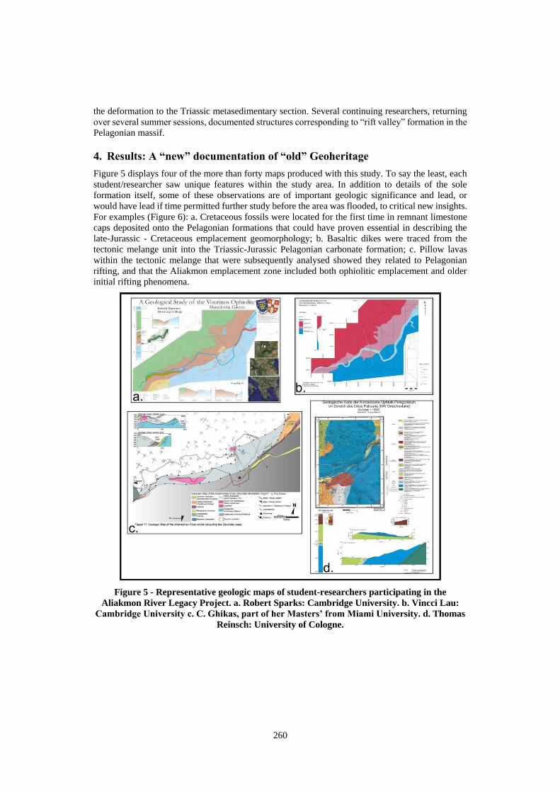
Figure 5 displays four of the more than forty maps produced with this study. To say the least, each
student/researcher saw unique features within the study area. In addition to details of the sole
formation itself, some of these observations are of important geologic significance and lead, or
would have lead if time permitted further study before the area was flooded, to critical new insights.
For examples (Figure 6): a. Cretaceous fossils were located for the first time in remnant limestone
caps deposited onto the Pelagonian formations that could have proven essential in describing the
late-Jurassic - Cretaceous emplacement geomorphology; b. Basaltic dikes were traced from the
tectonic melange unit into the Triassic-Jurassic Pelagonian carbonate formation; c. Pillow lavas
within the tectonic melange that were subsequently analysed showed they related to Pelagonian
rifting, and that the Aliakmon emplacement zone included both ophiolitic emplacement and older
initial rifting phenomena.
Figure 5 - Representative geologic maps of student-researchers participating in the
Aliakmon River Legacy Project. a. Robert Sparks: Cambridge University. b. Vincci Lau:
Cambridge University c. C. Ghikas, part of her Masters’ from Miami University. d. Thomas
Reinsch: University of Cologne.
261
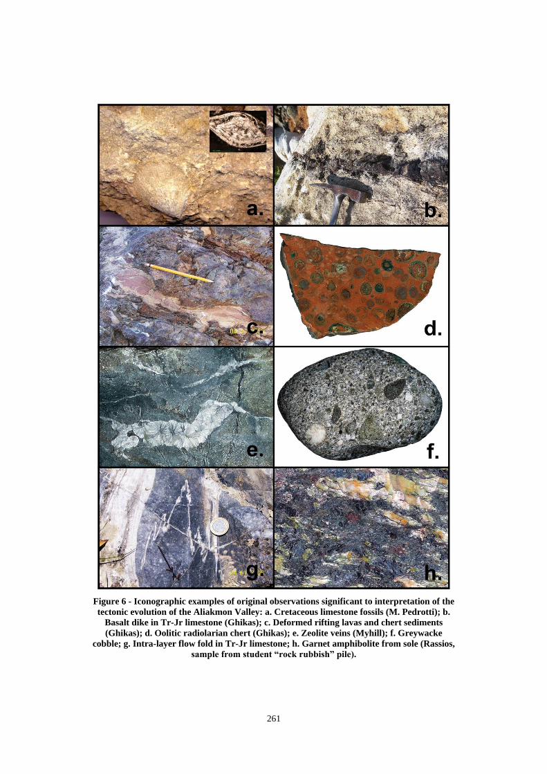
Figure 6 - Iconographic examples of original observations significant to interpretation of the
tectonic evolution of the Aliakmon Valley: a. Cretaceous limestone fossils (M. Pedrotti); b.
Basalt dike in Tr-Jr limestone (Ghikas); c. Deformed rifting lavas and chert sediments
(Ghikas); d. Oolitic radiolarian chert (Ghikas); e. Zeolite veins (Myhill); f. Greywacke
cobble; g. Intra-layer flow fold in Tr-Jr limestone; h. Garnet amphibolite from sole (Rassios,
sample from student “rock rubbish” pile).
262
5. Results: Relevance to “Cutting-edge” Science of the Vourinos-Vounassa
Ophiolite - Pelagonian Margin
Some results of the Aliakmon Legacy Project were presented at the 2008 International Ophiolite
Symposium (Rassios et al., 2008) which included the final conference field trip into the Aliakmon
Valley. Much of the petrologic diversity of the section was presented in a “light” geological book
by Rassios and the student researchers of the Legacy Project (Rassios and others, 2007). Both of
these publications were written too early in the analytical phases of the project data to cover the
comprehensive study of the section, nor does the present short paper allow a complete description
of the immense data base generated during and as a result of the Aliakmon Legacy Project. However,
a comparison of a short description of the Aliakmon Section predating the project can be compared
to the current model, synthesized from the work of the Aliakmon Legacy research group:
The Pre-Legacy Project Model (Rassios, 2004):
“The Vourinos Ophiolite is emplaced over the Pelagonian Massif with ‘bulldozed’ foreland basin
deposits entrapped in the collision zone and imprinted by metamorphism of the hot sole.”
The Current Model:
The Vourinos Ophiolite is bounded along its north and south margins by transcurrent faults (Rassios
and Moores, 2006) that accommodated complex compressional and strike-slip deformation as they
displaced the ophiolite to the northeast (Ghikas, 2007). In the south-eastern extreme of the ophiolite,
the fault is a wide zone, approaching a km in width, wherein the ophiolite-river section is overprinted
by tectonic motions that record a thrust environment of NE-movement with a “splay” to SE as the
thrust complex rotated its own margins/footwall as it moved forward. Garnets and amphiboles within
the sole contact indicate formation at temperatures of ~770oC ± 100oC and pressures of 4 ±1 kbar,
that is, the sole provenance would have been very close to the spreading system that created the
ophiolite (Myhill, 2011). Within the Aliakmon River valley, kinematic motions are depicted ranging
from ductile to brittle conditions. Along the Aliakmon River section, these movements merge the
original ophiolitic emplacement over sediments of the Ayios Nikolas Formation (Naylor et al., 1976)
with the transcurrent deformation: the fault - emplacement zone along the river section includes
plastic deformation of host Pelagonian carbonates, intercalation of highly deformed and altered
ophiolitic material, remnants of the garnet amphibolite/amphibolite ophiolitic sole, and preserves
older (Triassic) rifting lavas and sedimentation dating from the break-up of Pelagonia. The river
section is intruded by “leaks” of younger basalt and gabbro within the internal zone of the
transcurrent fault, some extending into older Pelagonian country rock. The southernmost contact of
the transcurrent fault formation parallels the extension of the Servian Fault along Mount Vounassa,
implying that this massive variation in rock competency accounted for the fault’s location. Thus, the
transcurrent fault once exposed along the Aliakmon River section is demonstrated to comprise a
major tectonic feature parasitically facilitating and recording over 200 million years of tectonic
history of the Pelagonian - Tethyan margin.
6. Final Statements:
We feel that in addition to the primary goal of the project, some valuable lessons in geoheritage
preservation were attained:
A re-investigation of a classic geological area brings new information and invites opportunities for
research: for examples, researchers of the Legacy project also began new study of the chrome ore
districts of the Vourinos Ophiolite leading to further investigation of the alteration processes of
chrome spinels. This lead to reconstruction of the metamorphic history of the complex that shows
that alteration Cr-spinel, with formation of a Fe-chromite - Cr-clinochlore assemblage, can occur
before ophiolite obduction (Grieco and Merlini, 2012). Recently, new cutting-edge studies by
Zlatkin (Zlatkin et al., 2014) of zircon dating within the Pelagonian complex near the Aliakmon
263
Legacy area, located the currently “oldest rocks in Greece” with zircons dated at ~980 my.
The success of the Legacy Project has improved the scientific knowledge base sufficiently to justify
inclusion of the Vounassa region within an aspiring Geopark (Geopark Grevena-Tethys); an
educational program similar to that of the Legacy Project is planned for the Geopark region.
Geoheritage is for future generations. It can allow new scientists to retrace the steps of those who
made the initial discoveries of geologic paradigms and allow them to continue along the path
towards new tectonic and petrogenetic innovation to the current paradigms.
Geoheritage aided in the advanced education of sixty up-and-coming geology students. These young
scientists are now located around the globe and are, themselves, now respected international
researchers. These students can be considered the core-group for passing onward the memory of
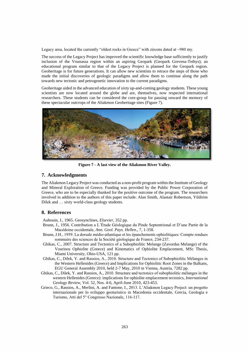
these spectacular outcrops of the Aliakmon Geoheritage sites (Figure 7).
Figure 7 - A last view of the Aliakmon River Valley.
7. Acknowledgments
The Aliakmon Legacy Project was conducted as a non-profit program within the Institute of Geology
and Mineral Exploration of Greece. Funding was provided by the Public Power Corporation of
Greece, who are to be especially thanked for the positive outcome of the program. The researchers
involved in addition to the authors of this paper include: Alan Smith, Alastair Robertson, Yildirim
Dilek and … sixty world-class geology students.
8. References
Aubouin, J., 1965. Geosynclines, Elsevier, 352 pp.
Brunn, J., 1956. Contribution a L’Étude Géologique du Pinde Septentrional et D’une Partie de la
Macédoine occidentale, Ann. Geol. Pays. Hellen., 7, 1-358.
Brunn, J.H., 1959. La dorsale médio-atlantique et les épanchements ophiolitiques: Compte rendues
sommaire des sciences de la Société géologique de France, 234-237.
Ghikas, C., 2007. Structure and Tectonics of a Subophiolitic Melange (Zavordas Melange) of the
Vourinos Ophiolite (Greece) and Kinematics of Ophiolite Emplacement, MSc Thesis,
Miami University, Ohio-USA, 121 pp.
Ghikas, C., Dilek, Y. and Rassios, A., 2010. Structure and Tectonics of Subophiolitic Mélanges in
the Western Hellenides (Greece) and Implications for Ophiolitic Root Zones in the Balkans,
EGU General Assembly 2010, held 2-7 May, 2010 in Vienna, Austria, 7282 pp.
Ghikas, C., Dilek, Y. and Rassios, A., 2010. Structure and tectonics of subophiolitic mélanges in the
western Hellenides (Greece): implications for ophiolite emplacement tectonics, International
Geology Review, Vol. 52, Nos. 4-6, April-June 2010, 423-453.
Grieco, G., Rassios, A., Merlini, A. and Fantone, I., 2013. L’Aliakmon Legacy Project: un progetto
internazionale per lo sviluppo geoturistico in Macedonia occidentale, Grecia, Geologia e
Turismo, Atti del 5° Congresso Nazionale, 116-117.
264
Grieco, G., Rassios, A.E., Merlini, A. and Fantone, I., 2014. The Aliakmon Legacy: a project for
geotouristic development in Western Macedonia, Greece, Bul. Shk. Gjeol. 1/2014 - Special
Issue, Proceedings of XX CBGA Congress, Tirana, Albania, 24-26 September 2014, 274-277.
Grieco, G. and Merlini, M., 2012. Chromite alteration processes within Vourinos Ophiolite, Int. J.
Earth Sci. (Geol. Rundsch.), 101, 1523-1533.
Heezen, B.C., Tharp, M. and Ewing, M., 1959. The Floors of the Oceans. I. The North Atlantic,
The Geological Society of America Special Paper, 65, 122 pp.
Moores, E.M., 1969. Petrology and structure of the Vourinos ophiolitic complex of northern
Greece: Geological Society of America Special Paper, 118, 74 pp.
Moores, E.M., 2003. A personal history of the ophiolite concept, Geological Society of America
Special Paper, 373, 17-29.
Myhill, R., 2008. Metamorphic Development beneath the Pindos-Vourinos-Ophiolite Slab, MSc
Thesis Cambridge University, 125 pp.
Myhill, R., 2011. Constraints on the evolution of the Mesohellenic Ophiolite from subophiolitic
metamorphic rocks. In: Wakabayashi, I. and Dilek, Y., eds, Mélanges: Processes of
Formation and Societal Signficance, Geol. Soc. Am. Spec. Paper, 480, 75-94.
Naylor, M., and Harle, T., 1976. Palaeogeographic significance of rocks and structures Beneath the
Vourinos ophiolite, northern Greece, Journal of the Geological Society, London, 132, 667-676.
Rassios, A., 2004. A Geologist’s Guide to West Macedonia, Greece, The Grevena Development
Agency, Grevena, 128 pp.
Rassios, A. and Aliakmon River Legacy Project Participants, 2007. Rocks in the Wild, I.G.M.E.
Athens, Greece. 128 pp.
Rassios, A., Smith, A. and Kostopoulos, D., 2008. GUIDEBOOK Ophiolites 2008: Link between
the Mesohellenic Ophiolites and Pelagonian Margin, West Thessaly and West Macedonia,
Greece, Inst. Of Geology and Mineral Research, 88 pp. Reprinted in Virtual Explorer, 2009.
http://www.virtualexplorer.com.au/journal/2009/34/.
Spray, J.G. and Roddick, J.C., 1980. Petrology and 40Ar/39Ar geochronology of some Hellenic
sub-ophiolitic metamorphic rocks, Contributions to Mineralogy and Petrology, 72, 43-55.
Wright, L., 1986. The effect of deformation on the Vourinos ophiolite. In: Rassios, A., Roberts,
S. and Vacondios, I., eds., The Application of a Multidisciplinary Concept for Chromite
Exploration in the Vourinos Complex (N. Greece), Inst. Mining and Mineral Exploration,
Athens, 156-216.
Zimmerman, J., 1968. Structure and Petrology of Rocks Underlying the Vourinos Ophiolitic
Complex, Northern Greece, PhD Thesis, Princeton University, 98 pp.
Zimmerman, J., 1969. The Vourinos Complex-an allochthonous alpine ophiolite in Northern
Greece, Abstr. Geol. Soc. Am. Ann. Mtg., 245.
Zimmerman, J., 1972. Emplacement of the Vourinos ophiolitic complex, northern Greece, Memoir
of the Geological Society of America, 132, 225-239.
Zlatkin, O., Avigad, D. and Gerdes, A., 2014. Peri-Amazonian provenance of the Proto Pelagonian
basement (Greece), from zircon U-Pb geochronology and Lu-Hf isotopic geochemistry,
Lithos, 184-187, 379-392.


![Screen Space Animation of Fire Fluids/ScreenSpaceFire.pdfThe pressure field (3) was first introduced in the setting of SPH by [Desbrun and Cani 1996]. Better mass preserving alternatives](https://static.fdocument.org/doc/165x107/5e82bd01001a9f4f5779d113/screen-space-animation-of-fire-fluidsscreenspacefirepdf-the-pressure-ield-3.jpg)