Morphometric Properties of Glacial Cirques in Zagros … Properties of Glacial Cirques in Zagros...
21
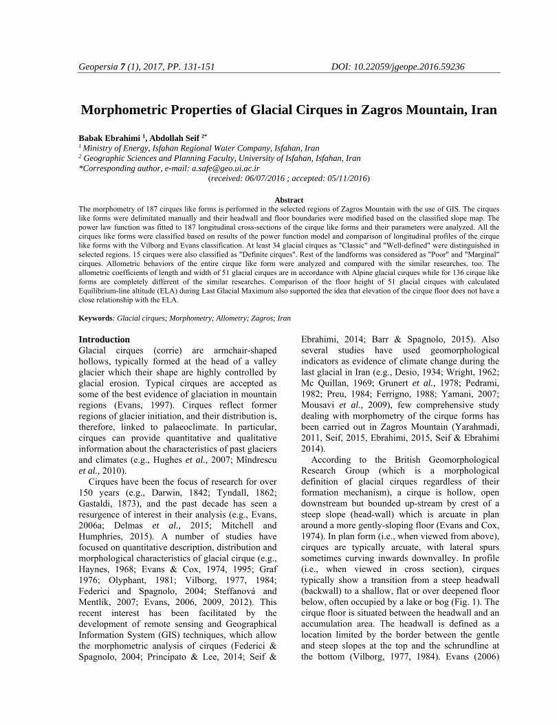
Geopersia 7 (1), 2017, PP. 131-151 DOI: 10.22059/jgeope.2016.59236 Morphometric Properties of Glacial Cirques in Zagros Mountain, Iran Babak Ebrahimi 1 , Abdollah Seif 2* 1 Ministry of Energy, Isfahan Regional Water Company, Isfahan, Iran 2 Geographic Sciences and Planning Faculty, University of Isfahan, Isfahan, Iran *Corresponding author, e-mail: [email protected] (received: 06/07/2016 ; accepted: 05/11/2016) Abstract The morphometry of 187 cirques like forms is performed in the selected regions of Zagros Mountain with the use of GIS. The cirques like forms were delimitated manually and their headwall and floor boundaries were modified based on the classified slope map. The power law function was fitted to 187 longitudinal cross-sections of the cirque like forms and their parameters were analyzed. All the cirques like forms were classified based on results of the power function model and comparison of longitudinal profiles of the cirque like forms with the Vilborg and Evans classification. At least 34 glacial cirques as "Classic" and "Well-defined" were distinguished in selected regions. 15 cirques were also classified as "Definite cirques". Rest of the landforms was considered as "Poor" and "Marginal" cirques. Allometric behaviors of the entire cirque like form were analyzed and compared with the similar researches, too. The allometric coefficients of length and width of 51 glacial cirques are in accordance with Alpine glacial cirques while for 136 cirque like forms are completely different of the similar researches. Comparison of the floor height of 51 glacial cirques with calculated Equilibrium-line altitude (ELA) during Last Glacial Maximum also supported the idea that elevation of the cirque floor does not have a close relationship with the ELA. Keywords: Glacial cirques; Morphometry; Allometry; Zagros; Iran Introduction Glacial cirques (corrie) are armchair-shaped hollows, typically formed at the head of a valley glacier which their shape are highly controlled by glacial erosion. Typical cirques are accepted as some of the best evidence of glaciation in mountain regions (Evans, 1997). Cirques reflect former regions of glacier initiation, and their distribution is, therefore, linked to palaeoclimate. In particular, cirques can provide quantitative and qualitative information about the characteristics of past glaciers and climates (e.g., Hughes et al., 2007; Mîndrescu et al., 2010). Cirques have been the focus of research for over 150 years (e.g., Darwin, 1842; Tyndall, 1862; Gastaldi, 1873), and the past decade has seen a resurgence of interest in their analysis (e.g., Evans, 2006a; Delmas et al., 2015; Mitchell and Humphries, 2015). A number of studies have focused on quantitative description, distribution and morphological characteristics of glacial cirque (e.g., Haynes, 1968; Evans & Cox, 1974, 1995; Graf 1976; Olyphant, 1981; Vilborg, 1977, 1984; Federici and Spagnolo, 2004; Steffanová and Mentlík, 2007; Evans, 2006, 2009, 2012). This recent interest has been facilitated by the development of remote sensing and Geographical Information System (GIS) techniques, which allow the morphometric analysis of cirques (Federici & Spagnolo, 2004; Principato & Lee, 2014; Seif & Ebrahimi, 2014; Barr & Spagnolo, 2015). Also several studies have used geomorphological indicators as evidence of climate change during the last glacial in Iran (e.g., Desio, 1934; Wright, 1962; Mc Quillan, 1969; Grunert et al., 1978; Pedrami, 1982; Preu, 1984; Ferrigno, 1988; Yamani, 2007; Mousavi et al., 2009), few comprehensive study dealing with morphometry of the cirque forms has been carried out in Zagros Mountain (Yarahmadi, 2011, Seif, 2015, Ebrahimi, 2015, Seif & Ebrahimi 2014). According to the British Geomorphological Research Group (which is a morphological definition of glacial cirques regardless of their formation mechanism), a cirque is hollow, open downstream but bounded up-stream by crest of a steep slope (head-wall) which is arcuate in plan around a more gently-sloping floor (Evans and Cox, 1974). In plan form (i.e., when viewed from above), cirques are typically arcuate, with lateral spurs sometimes curving inwards downvalley. In profile (i.e., when viewed in cross section), cirques typically show a transition from a steep headwall (backwall) to a shallow, flat or over deepened floor below, often occupied by a lake or bog (Fig. 1). The cirque floor is situated between the headwall and an accumulation area. The headwall is defined as a location limited by the border between the gentle and steep slopes at the top and the schrundline at the bottom (Vilborg, 1977, 1984). Evans (2006)
Transcript of Morphometric Properties of Glacial Cirques in Zagros … Properties of Glacial Cirques in Zagros...
Geopersia 7 (1), 2017, PP. 131-151 DOI: 10.22059/jgeope.2016.59236
Morphometric Properties of Glacial Cirques in Zagros Mountain, Iran
Babak Ebrahimi 1, Abdollah Seif 2* 1 Ministry of Energy, Isfahan Regional Water Company, Isfahan, Iran 2 Geographic Sciences and Planning Faculty, University of Isfahan, Isfahan, Iran *Corresponding author, e-mail: [email protected]
(received: 06/07/2016 ; accepted: 05/11/2016)
Abstract The morphometry of 187 cirques like forms is performed in the selected regions of Zagros Mountain with the use of GIS. The cirques like forms were delimitated manually and their headwall and floor boundaries were modified based on the classified slope map. The power law function was fitted to 187 longitudinal cross-sections of the cirque like forms and their parameters were analyzed. All the cirques like forms were classified based on results of the power function model and comparison of longitudinal profiles of the cirque like forms with the Vilborg and Evans classification. At least 34 glacial cirques as "Classic" and "Well-defined" were distinguished in selected regions. 15 cirques were also classified as "Definite cirques". Rest of the landforms was considered as "Poor" and "Marginal" cirques. Allometric behaviors of the entire cirque like form were analyzed and compared with the similar researches, too. The allometric coefficients of length and width of 51 glacial cirques are in accordance with Alpine glacial cirques while for 136 cirque like forms are completely different of the similar researches. Comparison of the floor height of 51 glacial cirques with calculated Equilibrium-line altitude (ELA) during Last Glacial Maximum also supported the idea that elevation of the cirque floor does not have a close relationship with the ELA. Keywords: Glacial cirques; Morphometry; Allometry; Zagros; Iran Introduction Glacial cirques (corrie) are armchair-shaped hollows, typically formed at the head of a valley glacier which their shape are highly controlled by glacial erosion. Typical cirques are accepted as some of the best evidence of glaciation in mountain regions (Evans, 1997). Cirques reflect former regions of glacier initiation, and their distribution is, therefore, linked to palaeoclimate. In particular, cirques can provide quantitative and qualitative information about the characteristics of past glaciers and climates (e.g., Hughes et al., 2007; Mîndrescu et al., 2010).
Cirques have been the focus of research for over 150 years (e.g., Darwin, 1842; Tyndall, 1862; Gastaldi, 1873), and the past decade has seen a resurgence of interest in their analysis (e.g., Evans, 2006a; Delmas et al., 2015; Mitchell and Humphries, 2015). A number of studies have focused on quantitative description, distribution and morphological characteristics of glacial cirque (e.g., Haynes, 1968; Evans & Cox, 1974, 1995; Graf 1976; Olyphant, 1981; Vilborg, 1977, 1984; Federici and Spagnolo, 2004; Steffanová and Mentlík, 2007; Evans, 2006, 2009, 2012). This recent interest has been facilitated by the development of remote sensing and Geographical Information System (GIS) techniques, which allow the morphometric analysis of cirques (Federici & Spagnolo, 2004; Principato & Lee, 2014; Seif &
Ebrahimi, 2014; Barr & Spagnolo, 2015). Also several studies have used geomorphological indicators as evidence of climate change during the last glacial in Iran (e.g., Desio, 1934; Wright, 1962; Mc Quillan, 1969; Grunert et al., 1978; Pedrami, 1982; Preu, 1984; Ferrigno, 1988; Yamani, 2007; Mousavi et al., 2009), few comprehensive study dealing with morphometry of the cirque forms has been carried out in Zagros Mountain (Yarahmadi, 2011, Seif, 2015, Ebrahimi, 2015, Seif & Ebrahimi 2014).
According to the British Geomorphological Research Group (which is a morphological definition of glacial cirques regardless of their formation mechanism), a cirque is hollow, open downstream but bounded up-stream by crest of a steep slope (head-wall) which is arcuate in plan around a more gently-sloping floor (Evans and Cox, 1974). In plan form (i.e., when viewed from above), cirques are typically arcuate, with lateral spurs sometimes curving inwards downvalley. In profile (i.e., when viewed in cross section), cirques typically show a transition from a steep headwall (backwall) to a shallow, flat or over deepened floor below, often occupied by a lake or bog (Fig. 1). The cirque floor is situated between the headwall and an accumulation area. The headwall is defined as a location limited by the border between the gentle and steep slopes at the top and the schrundline at the bottom (Vilborg, 1977, 1984). Evans (2006)
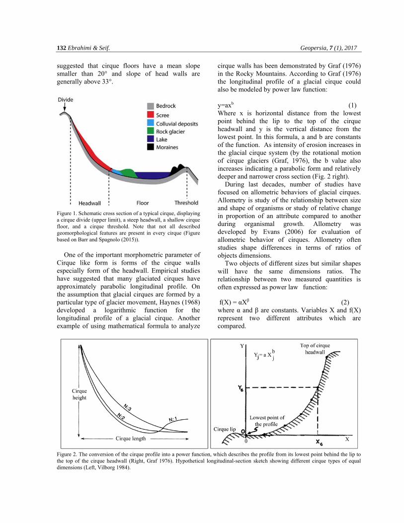
132 Ebrahimi & Seif. Geopersia, 7 (1), 2017
suggested that cirque floors have a mean slope smaller than 20° and slope of head walls are generally above 33°.
Figure 1. Schematic cross section of a typical cirque, displaying a cirque divide (upper limit), a steep headwall, a shallow cirque floor, and a cirque threshold. Note that not all described geomorphological features are present in every cirque (Figure based on Barr and Spagnolo (2015)).
One of the important morphometric parameter of
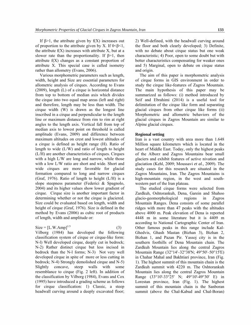
Cirque like form is forms of the cirque walls especially form of the headwall. Empirical studies have suggested that many glaciated cirques have approximately parabolic longitudinal profile. On the assumption that glacial cirques are formed by a particular type of glacier movement, Haynes (1968) developed a logarithmic function for the longitudinal profile of a glacial cirque. Another example of using mathematical formula to analyze
cirque walls has been demonstrated by Graf (1976) in the Rocky Mountains. According to Graf (1976) the longitudinal profile of a glacial cirque could also be modeled by power law function:
y=axb (1) Where x is horizontal distance from the lowest point behind the lip to the top of the cirque headwall and y is the vertical distance from the lowest point. In this formula, a and b are constants of the function. As intensity of erosion increases in the glacial cirque system (by the rotational motion of cirque glaciers (Graf, 1976), the b value also increases indicating a parabolic form and relatively deeper and narrower cross section (Fig. 2 right).
During last decades, number of studies have focused on allometric behaviors of glacial cirques. Allometry is study of the relationship between size and shape of organisms or study of relative change in proportion of an attribute compared to another during organismal growth. Allometry was developed by Evans (2006) for evaluation of allometric behavior of cirques. Allometry often studies shape differences in terms of ratios of objects dimensions.
Two objects of different sizes but similar shapes will have the same dimensions ratios. The relationship between two measured quantities is often expressed as power law function: f(X) = αXβ (2) where α and β are constants. Variables X and f(X) represent two different attributes which are compared.
Figure 2. The conversion of the cirque profile into a power function, which describes the profile from its lowest point behind the lip to the top of the cirque headwall (Right, Graf 1976). Hypothetical longitudinal-section sketch showing different cirque types of equal dimensions (Left, Vilborg 1984).
Morphometric Properties of Glacial Cirques in Zagros Mountain, Iran 133
If β>1, the attribute given by f(X) increases out of proportion to the attribute given by X. If 0<β<1, the attribute f(X) increases with attribute X, but at a slower rate than the proportionality. If β=1, then attribute f(X) changes as a constant proportion of attribute X. This special case is called isometry rather than allometry (Evans, 2006).
Various morphometric parameters such as length, width, height and Size are essential parameters for allometric analysis of cirques. According to Evans (2009), length (L) of a cirque is horizontal distance from top to bottom of median axis which divides the cirque into two equal map areas (left and right) and therefore, length may be less than width. The cirque width (W) is drawn as the longest line inscribed in a cirque and perpendicular to the length line or maximum distance from rim to rim at right angles to the length axis. Vertical fall from top of median axis to lowest point on threshold is called amplitude (Evans, 2009) and difference between maximum altitudes on crest and lowest altitudes of a cirque is defined as height range (H). Ratio of length to wide (L/W) and ratio of length to height (L/H) are another characteristics of cirques. Cirques with a high L/W are long and narrow, while those with a low L/W ratio are short and wide. Short and wide cirques are more favorable for glacial formation compared to long and narrow cirques (Graf, 1976). Ratio of length to height (L/H) is a slope steepness parameter (Federici & Spagnolo, 2004) and its higher values show lower gradient of cirque. Cirque size is another important factor in determining whether or not the cirque is glaciered. Size could be evaluated based on length, width and height of cirque (Graf, 1976). Size is defined in the method by Evans (2006) as cubic root of products of length, width and amplitude or:
Size = [L.W.Amp]1/3 (3) Vilborg (1984) has developed the following classification system of cirque or cirque-like form: N-l) Well developed cirque, deeply cut in bedrock; N-2) Rather distinct cirque but less incised in bedrock than the N-l forms; N-3) Not very well developed cirque in spite of more or less cutting in bedrock; N-4) Strongly demolished cirque and N-5) Slightly concave, steep walls with some resemblance to cirque (Fig. 2 left). In addition of the classification by Vilborg (1984), Evans and Cox (1995) have introduced a grading scheme as follows for cirque classification: 1) Classic, a steep headwall curving around a deeply excavated floor;
2) Well-defined, with the headwall curving around the floor and both clearly developed; 3) Definite, with no debate about cirque status but one weak characteristic; 4) Poor, open to some doubt but with better characteristics compensating for weaker ones and 5) Marginal, open to debate on cirque status and origin.
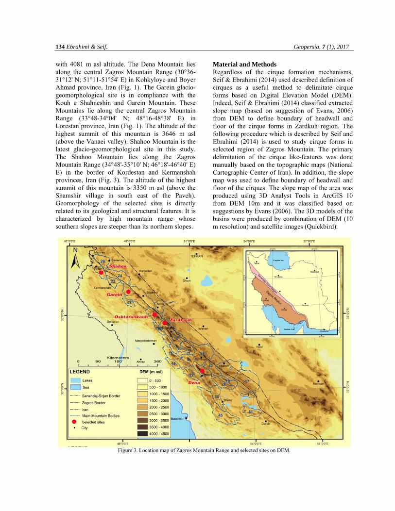
The aim of this paper is morphometric analysis of cirque forms in GIS environment in order to study the cirque like-features of Zagros Mountain. The main hypothesis of this paper may be summarized as follows: (i) method introduced by Seif and Ebrahimi (2014) is a useful tool for delimitation of the cirque like form and separating glacial cirques from other cirque like forms (ii) Morphometric and allometric behaviors of the glacial cirques in Zagros Mountain are similar to Alpine glacial cirques. Regional setting Iran is a vast country with area more than 1.648 Million square kilometers which is located in the heart of Middle East. Today, only the highest peaks of the Alborz and Zagros Mountains bear small glaciers and exhibit features of active nivation and glaciation (Kehl, 2009; Moussavi et al., 2009). The study cases for this research are situated in the Zagros Mountains, Iran. The Zagros Mountains is high-mountain region, in the west and south-western part of the Iran plateau.
The studied cirque forms were selected from Zardkuh, Oshtorankuh, Dena, Garein and Shahoo glacio-geomorphological regions in Zagros Mountain Ranges. Dena consists of some parallel ridges with more than 47 peaks with the altitudes above 4000 m. Peak elevation of Dena is reported 4448 m in some literature but it is 4409 m according to National Cartographic Center of Iran. Other famous peaks in this range include Kal-Ghedvis, Ghash Mastan (Bizhan 3), Bizhan 2, Bizhan 1, and Pazan Pir. Yassoj city is in the southern foothills of Dena Mountain chain. The Zardkuh Mountain lies along the central Zagros Mountain Range (32°14'–32°38'N; 49°50'–50°15'E) in Chahar Mahal and Bakhtiari province, Iran (Fig. 1). The highest summit of this mountain chain is the Zardkuh summit with 4220 m. The Oshtorankuh Mountain lies along the central Zagros Mountain Range (33°10'-33°25' N; 49°10'-49°30' E) in Lorestan province, Iran (Fig. 1). The highest summit of this mountain chain is the Sanboran summit (above the Chal-Kabud and Chal-Boran)
134 Ebrahimi & Seif. Geopersia, 7 (1), 2017
with 4081 m asl altitude. The Dena Mountain lies along the central Zagros Mountain Range (30°36-31°12' N; 51°11-51°54' E) in Kohkyloye and Boyer Ahmad province, Iran (Fig. 1). The Garein glacio-geomorphological site is in compliance with the Kouh e Shahneshin and Garein Mountain. These Mountains lie along the central Zagros Mountain Range (33°48-34°04' N; 48°16-48°38' E) in Lorestan province, Iran (Fig. 1). The altitude of the highest summit of this mountain is 3646 m asl (above the Vanaei valley). Shahoo Mountain is the latest glacio-geomorphological site in this study. The Shahoo Mountain lies along the Zagros Mountain Range (34°48'-35°10' N; 46°18'-46°40' E) E) in the border of Kordestan and Kermanshah provinces, Iran (Fig. 3). The altitude of the highest summit of this mountain is 3350 m asl (above the Shamshir village in south east of the Paveh). Geomorphology of the selected sites is directly related to its geological and structural features. It is characterized by high mountain range whose southern slopes are steeper than its northern slopes.
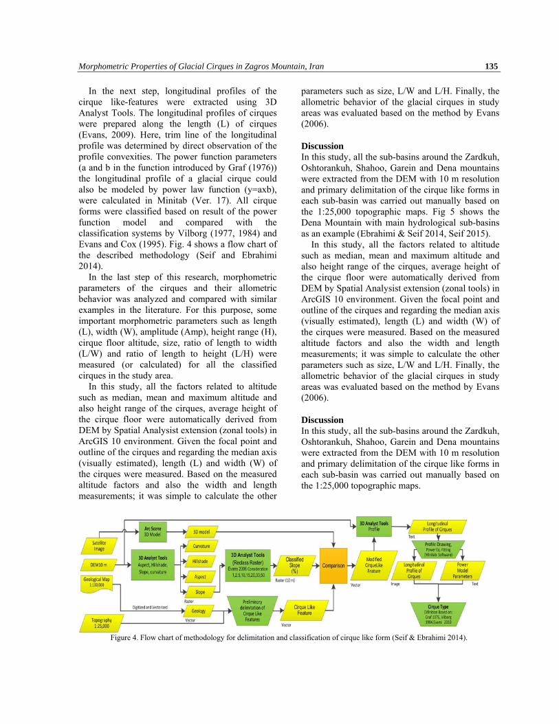
Material and Methods Regardless of the cirque formation mechanisms, Seif & Ebrahimi (2014) used described definition of cirques as a useful method to delimitate cirque forms based on Digital Elevation Model (DEM). Indeed, Seif & Ebrahimi (2014) classified extracted slope map (based on suggestion of Evans, 2006) from DEM to define boundary of headwall and floor of the cirque forms in Zardkuh region. The following procedure which is described by Seif and Ebrahimi (2014) is used to study cirque forms in selected region of Zagros Mountain. The primary delimitation of the cirque like-features was done manually based on the topographic maps (National Cartographic Center of Iran). In addition, the slope map was used to define boundary of headwall and floor of the cirques. The slope map of the area was produced using 3D Analyst Tools in ArcGIS 10 from DEM 10m and it was classified based on suggestions by Evans (2006). The 3D models of the basins were produced by combination of DEM (10 m resolution) and satellite images (Quickbird).
Figure 3. Location map of Zagros Mountain Range and selected sites on DEM.
Morphometric Properties of Glacial Cirques in Zagros Mountain, Iran 135
In the next step, longitudinal profiles of the cirque like-features were extracted using 3D Analyst Tools. The longitudinal profiles of cirques were prepared along the length (L) of cirques (Evans, 2009). Here, trim line of the longitudinal profile was determined by direct observation of the profile convexities. The power function parameters (a and b in the function introduced by Graf (1976)) the longitudinal profile of a glacial cirque could also be modeled by power law function (y=axb), were calculated in Minitab (Ver. 17). All cirque forms were classified based on result of the power function model and compared with the classification systems by Vilborg (1977, 1984) and Evans and Cox (1995). Fig. 4 shows a flow chart of the described methodology (Seif and Ebrahimi 2014).
In the last step of this research, morphometric parameters of the cirques and their allometric behavior was analyzed and compared with similar examples in the literature. For this purpose, some important morphometric parameters such as length (L), width (W), amplitude (Amp), height range (H), cirque floor altitude, size, ratio of length to width (L/W) and ratio of length to height (L/H) were measured (or calculated) for all the classified cirques in the study area.
In this study, all the factors related to altitude such as median, mean and maximum altitude and also height range of the cirques, average height of the cirque floor were automatically derived from DEM by Spatial Analysist extension (zonal tools) in ArcGIS 10 environment. Given the focal point and outline of the cirques and regarding the median axis (visually estimated), length (L) and width (W) of the cirques were measured. Based on the measured altitude factors and also the width and length measurements; it was simple to calculate the other
parameters such as size, L/W and L/H. Finally, the allometric behavior of the glacial cirques in study areas was evaluated based on the method by Evans (2006). Discussion In this study, all the sub-basins around the Zardkuh, Oshtorankuh, Shahoo, Garein and Dena mountains were extracted from the DEM with 10 m resolution and primary delimitation of the cirque like forms in each sub-basin was carried out manually based on the 1:25,000 topographic maps. Fig 5 shows the Dena Mountain with main hydrological sub-basins as an example (Ebrahimi & Seif 2014, Seif 2015).
In this study, all the factors related to altitude such as median, mean and maximum altitude and also height range of the cirques, average height of the cirque floor were automatically derived from DEM by Spatial Analysist extension (zonal tools) in ArcGIS 10 environment. Given the focal point and outline of the cirques and regarding the median axis (visually estimated), length (L) and width (W) of the cirques were measured. Based on the measured altitude factors and also the width and length measurements; it was simple to calculate the other parameters such as size, L/W and L/H. Finally, the allometric behavior of the glacial cirques in study areas was evaluated based on the method by Evans (2006). Discussion In this study, all the sub-basins around the Zardkuh, Oshtorankuh, Shahoo, Garein and Dena mountains were extracted from the DEM with 10 m resolution and primary delimitation of the cirque like forms in each sub-basin was carried out manually based on the 1:25,000 topographic maps.
Figure 4. Flow chart of methodology for delimitation and classification of cirque like form (Seif & Ebrahimi 2014).
136 Ebrahimi & Seif. Geopersia, 7 (1), 2017
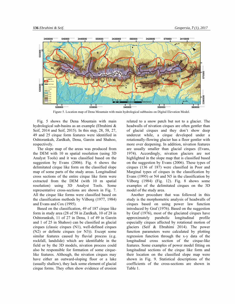
Figure 5. Location map of Dena Mountain with main hydrological subbasins on Digital Elevation Model.
Fig. 5 shows the Dena Mountain with main
hydrological sub-basins as an example (Ebrahimi & Seif, 2014 and Seif, 2015). In this step, 28, 58, 27, 49 and 25 cirque form features were identified in Oshtorankuh, Zardkuh, Dena, Garein and Shahoo, respectively.
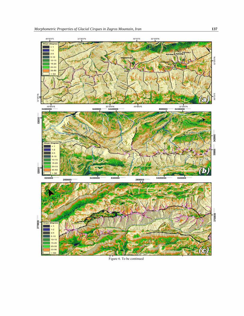
The slope map of the areas was produced from the DEM with 10 m spatial resolution (using 3D Analyst Tools) and it was classified based on the suggestion by Evans (2006). Fig. 6 shows the delimitated cirque like form on the classified slope map of some parts of the study areas. Longitudinal cross sections of the entire cirque like form were extracted from the DEM (with 10 m spatial resolution) using 3D Analyst Tools. Some representative cross-sections are shown in Fig. 7. All the cirque like forms were classified based on the classification methods by Vilborg (1977, 1984) and Evans and Cox (1995).
Based on the classification, 49 of 187 cirque like form in study area (28 of 58 in Zardkuh, 10 of 28 in Oshtorankuh, 11 of 27 in Dena, 1 of 49 in Garein and 1 of 25 in Shahoo) can be classified as glacial cirques (classic cirques (N1), well-defined cirques (N2) or definite cirques (or N3)). Except some similar features caused by fluvial process (e.g. rockfall, landslide) which are identifiable in the field or by the 3D models, nivation process could also be responsible for formation of some cirque-like features. Although, the nivation cirques may have either an outward-sloping floor or a lake (usually shallow), they lack some element of glacial cirque forms. They often show evidence of erosion
related to a snow patch but not to a glacier. The headwalls of nivation cirques are often gentler than of glacial cirques and they don’t show deep undercut while, a cirque developed under a rotationally-flowing glacier has a floor gentler with more over deepening. In addition, nivation features are usually smaller than glacial cirques (Evans, 1974). Accordingly, nivation glaciers are not highlighted in the slope map that is classified based on the suggestion by Evans (2006). These types of cirques (136 of 187) were classified in Poor and Marginal types of cirques in the classification by Evans (1995) or N4 and N5 in the classification by Vilborg (1984) (Fig. 12). Fig. 8 shows some examples of the delimitated cirques on the 3D model of the study area.
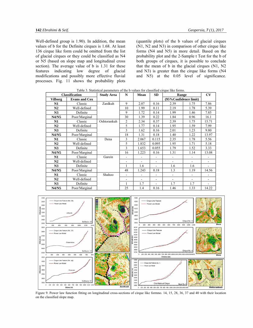
Another procedure that was followed in this study is the morphometric analysis of headwalls of cirques based on using power law function introduced by Graf (1976). Based on the suggestion by Graf (1976), most of the glaciated cirques have approximately parabolic longitudinal profile especially cirques affected by rotational motion of glaciers (Seif & Ebrahimi 2014). The power function parameters were calculated by plotting regression function through the x-y data of the longitudinal cross section of the cirque-like features. Some examples of power model fitting on longitudinal sections of the cirque like form and their location on the classified slope map were shown in Fig. 9. Statistical descriptions of the coefficients of the cross-sections are shown in Table 1.
Morphometric Properties of Glacial Cirques in Zagros Mountain, Iran 137
Figure 6. To be continued
138 Ebrahimi & Seif. Geopersia, 7 (1), 2017
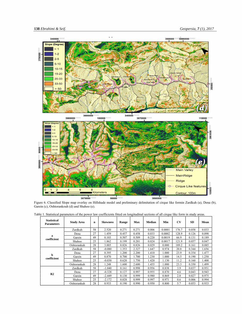
Figure 6. Classified Slope map overlay on Hillshade model and preliminary delimitation of cirque like formin Zardkuh (a), Dena (b), Garein (c), Oshtorankouh (d) and Shahoo (e). Table 1. Statistical parameters of the power law coefficients fitted on longitudinal sections of all cirque like form in study areas.
Mean SD CV Min Median Max Range Skewness n Study Area Statistical
Parameters
0.033 0.058 176.7 0.0001 0.006 0.271 0.271 2.520 58 Zardkuh
a coefficient
0.098 0.126 128.9 0.0002 0.033 0.458 0.457 1.459 27 Dena 0.189 0.131 66.9 0.0019 0.220 0.509 0.507 0.103 49 Garein 0.047 0.057 121.9 0.0017 0.024 0.201 0.199 1.862 25 Shahoo 0.085 0.161 189.2 0.000 0.029 0.826 0.826 3.885 28 Oshtorankuh 1.656 0.344 20.8 0.974 1.647 2.327 1.353 -0.080 58 Zardkuh
b coefficient
1.477 0.354 23.9 1.000 1.410 2.200 1.200 0.395 27 Dena 1.250 0.190 14.5 1.000 1.230 1.700 0.700 0.870 49 Garein 1.400 0.160 11.2 1.130 1.420 1.750 0.620 -0.030 25 Shahoo 1.499 0.350 23.3 1.000 1.455 2.600 1.600 1.248 28 Oshtorankuh 0.951 0.037 3.9 0.838 0.956 0.998 0.161 -1.040 58 Zardkuh
R2
0.943 0.043 4.6 0.870 0.955 0.997 0.127 -0.328 27 Dena 0.975 0.027 2.8 0.869 0.980 0.999 0.130 -2.449 49 Garein 0.994 0.006 0.6 0.971 0.997 0.999 0.028 -2.172 25 Shahoo 0.933 0.053 5.7 0.800 0.950 0.990 0.190 0.933 28 Oshtorankuh
Morphometric Properties of Glacial Cirques in Zagros Mountain, Iran 139
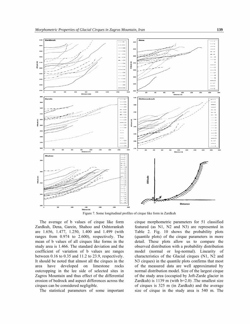
Figure 7. Some longitudinal profiles of cirque like form in Zardkuh
The average of b values of cirque like form
Zardkuh, Dena, Garein, Shahoo and Oshtorankuh are 1.656, 1.477, 1.250, 1.400 and 1.499 (with ranges from 0.974 to 2.600), respectively. The mean of b values of all cirques like forms in the study area is 1.466. The standard deviation and the coefficient of variation of b values are ranges between 0.16 to 0.35 and 11.2 to 23.9, respectively. It should be noted that almost all the cirques in the area have developed on limestone rocks outcropping in the lee side of selected sites in Zagros Mountain and thus effect of the differential erosion of bedrock and aspect differences across the cirques can be considered negligible.
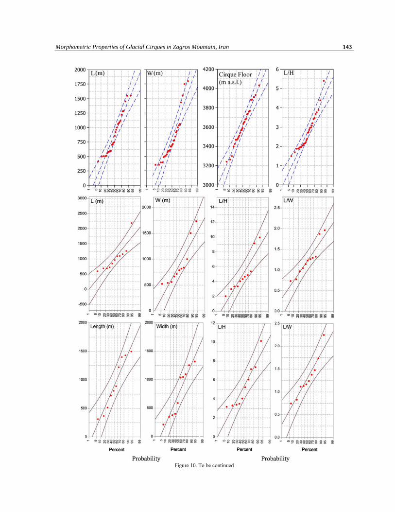
The statistical parameters of some important
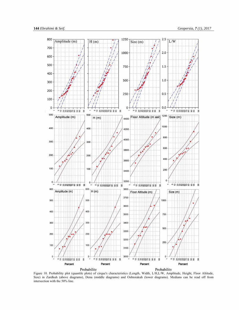
cirque morphometric parameters for 51 classified featured (as N1, N2 and N3) are represented in Table 2. Fig. 10 shows the probability plots (quantile plots) of the cirque parameters in more detail. These plots allow us to compare the observed distribution with a probability distribution model (normal or log-normal). Linearity of characteristics of the Glacial cirques (N1, N2 and N3 cirques) in the quantile plots confirms that most of the measured data are well approximated by normal distribution model. Size of the largest cirque of the study area (occupied by Joft-Zarde glacier in Zardkuh) is 1139 m (with b=2.0) .The smallest size of cirques is 325 m (in Zardkuh) and the average size of cirque in the study area is 540 m. The
140 Ebrahimi & Seif. Geopersia, 7 (1), 2017
average Length of cirques is 929 m and their maximum and minimum lengths are 2190 m and 312 m, respectively. The average width of the
cirque in the study area is 814 m. This means that the cirques are of moderate size that compared to the other glacial cirques in Alpine mountain.
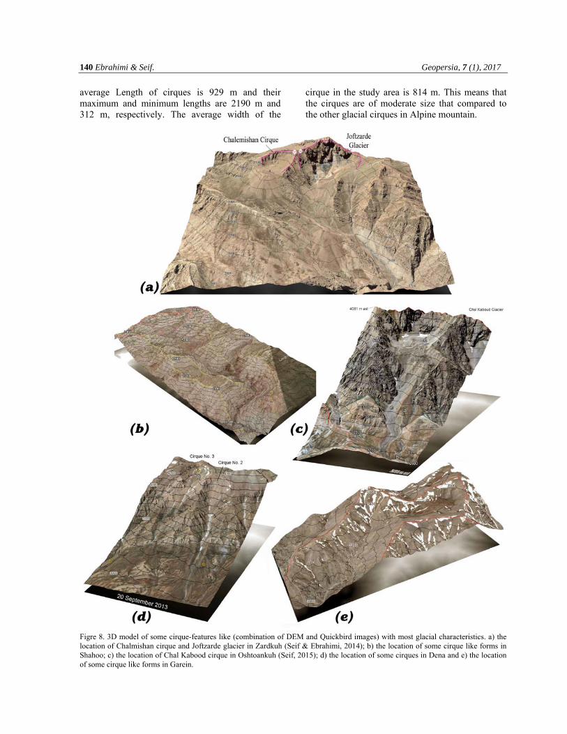
Figre 8. 3D model of some cirque-features like (combination of DEM and Quickbird images) with most glacial characteristics. a) the location of Chalmishan cirque and Joftzarde glacier in Zardkuh (Seif & Ebrahimi, 2014); b) the location of some cirque like forms in Shahoo; c) the location of Chal Kabood cirque in Oshtoankuh (Seif, 2015); d) the location of some cirques in Dena and e) the location of some cirque like forms in Garein.
Morphometric Properties of Glacial Cirques in Zagros Mountain, Iran 141
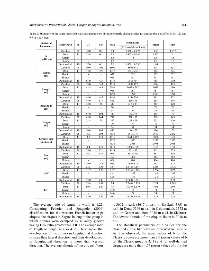
Table 2. Summary of the some important statistical parameters of morphometric characteristics for cirques that classified as N1, N2 and N3 in study areas
The average ratio of length to width is 1.22.
Considering Federici and Spagnolo (2004) classification for the western French-Italian Alps cirques, the cirques in Zagros belong to the group in which cirques were occupied by a valley glacier having L/W ratio greater than 1.0. The average ratio of length to height is also 4.36. These mean that development of the cirques in longitudinal direction is more than lateral direction and their development in longitudinal direction is more than vertical direction. The average altitude of the cirques floors
is 3602 m a.s.l. (3617 m a.s.l. in Zardkuh, 3851 m a.s.l. in Dena, 3366 m a.s.l. in Oshtorankuh, 3372 m a.s.l. in Garein and from 3038 m a.s.l. in Shahoo). The lowest altitude of the cirques floors is 3038 m a.s.l..
The statistical parameters of b values for the classified cirque like form are presented in Table 3. As it is observed, the mean values of b for the Classic cirques are more than 2.0 (mean values of b for the Classic group is 2.11) and for well-defined cirques are more than 1.77 (mean values of b for the
Min Mean Mean range
Max SD CV n Study Area Statistical
Parameters (95% confidence limit)
1.537 1.93 1.930 ± 0.073 2.3 0.2 10.0 28 Zardkuh
b coefficient
1 1.477 1.477 ± 0.140 2.2 0.3 23.9 11 Dena 1.6 1.6 1.6 1.6 - - 1 Garein 1.7 1.7 1.7 1.7 - - 1 Shahoo 1.5 1.84 1.839 ± 0.230 2.6 0.3 17.0 10 Oshtorankuh 353 805 805± 148 1800 402 50.0 28 Zardkuh
Width (m)
525 882 882 ± 266 1737 395 44.8 11 Dena 692 692 692 692 - - 1 Garein 951 951 951 951 - - 1 Shahoo 210 765 765± 301 1318 421 55.0 10 Oshtorankuh 413 880 880± 127 1555 343 39.0 28 Zardkuh
Length (m)
600 1033 1033 ± 297 2190 443 42.8 11 Dena 981 981 981 981 - - 1 Garein
1290 1290 1290 1290 - - 1 Shahoo 312 915 915± 320 1496 447 48.0 10 Oshtorankuh 116 268 268± 43 611 117 44.0 28 Zardkuh
Amplitude (m)
120 215 215 ± 47 340 71 32.8 11 Dena 70 70 70 70 - - 1 Garein 54 54 54 54 - - 1 Shahoo 70 182 182± 75 440 104 57.0 10 Oshtorankuh 145 338 338± 53 791 144 43.0 28 Zardkuh
Height (m)
120 228 228 ± 50 370 75 32.8 11 Dena 70 70 70 70 - - 1 Garein 54 54 54 54 - - 1 Shahoo 70 186 186± 75 440 105 56.0 10 Oshtorankuh
3242 3617 3617± 76 4030 204 6.0 28 Zardkuh
Cirque Floor (m A.S.L.)
3558 3851 3851 ± 107 4136 159 4.1 11 Dena 3372 3372 3372 3372 - - 1 Garein 3038 3038 3038 3038 - - 1 Shahoo 3150 3366 3366± 106 3610 149 4.4 10 Oshtorankuh 325 561 561± 82 1139 221 39.0 28 Zardkuh
Size (m)
376 561 561 ± 100 913 150 26.8 11 Dena 362 362 362 362 - - 1 Garein 404 404 404 404 - - 1 Shahoo 175 493 494± 175 953 244 49.0 10 Oshtorankuh
0.776 1.166 1.116± 0.114 1.87 0.31 26.5 28 Zardkuh
L/W 0.73 1.236 1.236± 0.263 1.97 0.39 31.7 11 Dena 1.42 1.42 1.42 1.42 - - 1 Garein 1.36 1.36 1.36 1.36 - - 1 Shahoo 0.74 1.31 1.308± 0.315 2.25 0.40 33.0 10 Oshtorankuh 1.508 2.74 2.740± 0.339 5.4 0.91 33.4 28 Zardkuh
L/H 2.06 4.92 4.920± 1.670 9.9 2.49 50.5 11 Dena 14 14 14 14.0 - - 1 Garein 24 24 24 24.0 - - 1 Shahoo
3.21 5.33 5.335± 1.659 10.1 2.32 43.0 10 Oshtorankuh
142 Ebrahimi & Seif. Geopersia, 7 (1), 2017
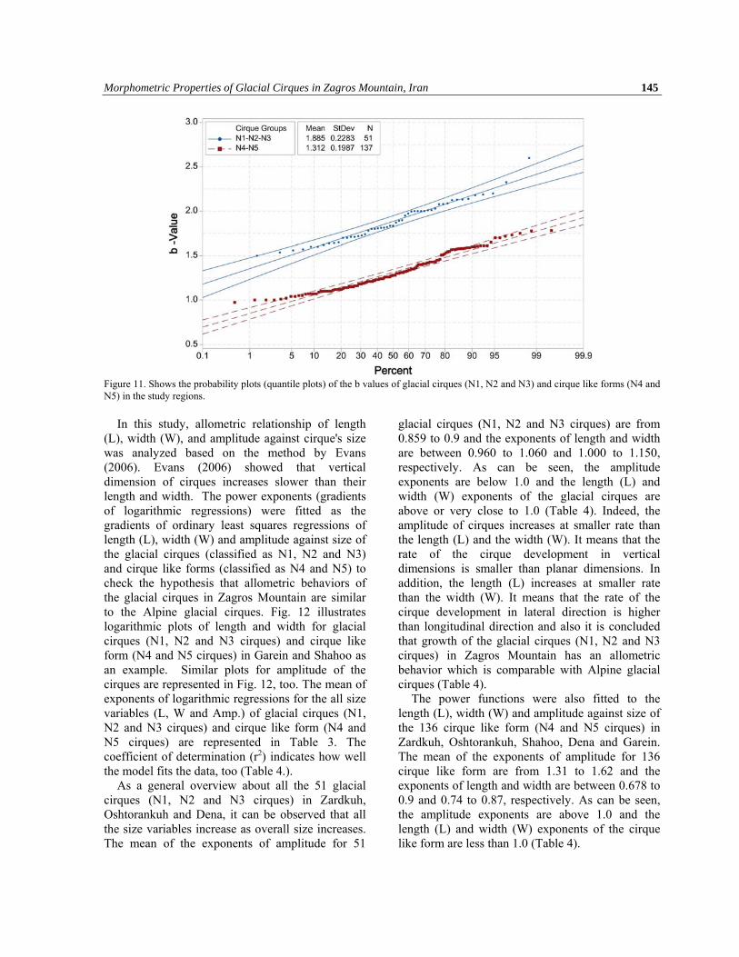
Well-defined group is 1.90). In addition, the mean values of b for the Definite cirques is 1.68. At least 136 cirque like form could be omitted from the list of glacial cirques or they could be classified as N4 or N5 (based on slope map and longitudinal cross section). The average value of b is 1.31 for these features indicating low degree of glacial modifications and possibly more effective fluvial processes. Fig. 11 shows the probability plots
(quantile plots) of the b values of glacial cirques (N1, N2 and N3) in comparison of other cirque like forms (N4 and N5) in more detail. Based on the probability plot and the 2-Sample t Test for the b of both groups of cirques, it is possible to conclude that the mean of b in the glacial cirques (N1, N2 and N3) is greater than the cirque like forms (N4 and N5) at the 0.05 level of significance.
Table 3. Statistical parameters of the b values for classified cirque like forms.
CV Range SD Mean N Study Area Classification (95%Confidence limit) Evans and Cox Vilborg
7.86 1.75 2.39 0.16 2.07 9 Zardkuh Classic N1 5.391.78 2.190.111.9910Well-defined N2 7.85 1.46 1.99 0.14 1.72 9 Definite N3 16.1 0.96 1.84 0.22 1.39 30 Poor/Marginal N4/N5 15.71 1.75 2.39 0.37 2.34 2 Oshtorankuh Classic N1 7.991.59 1.950.141.775Well-defined N2 9.80 1.23 2.01 0.16 1.62 3 Definite N3 13.97 1.22 1.40 0.18 1.31 18 Poor/Marginal N4/N5 5.56 1.78 2.35 0.115 2.067 3 Dena Classic N1 5.181.71 1.950.0951.8325Well-defined N2 3.33 1.52 1.79 0.055 1.653 3 Definite N3 13.08 1.14 1.31 0.16 1.223 16 Poor/Marginal N4/N5
- - - - - - Garein Classic N1 - - - - - - Well-defined N2 - 1.6 1.6 - 1.6 1 Definite N3
14.56 1.19 1.3 0.18 1.243 48 Poor/Marginal N4/N5 - - - - - - Shahoo Classic N1 - - - - - - Well-defined N2 - 1.7 1.7 - 1.7 1 Definite N3
14.22 1.33 1.46 0.16 1.4 25 Poor/Marginal N4/N5
Figure 9. Power law function fitting on longitudinal cross-sections of cirque like formno. 14, 15, 28, 36, 37 and 40 with their location on the classified slope map.
Morphometric Properties of Glacial Cirques in Zagros Mountain, Iran 143
Figure 10. To be continued
144 Ebrahimi & Seif. Geopersia, 7 (1), 2017
Figure 10. Probability plot (quantile plots) of cirque's characteristics (Length, Width, L/H,L/W, Amplitude, Height, Floor Altitude, Size) in Zardkuh (above diagrams), Dena (middle diagrams) and Oshtorakuh (lower diagrams). Medians can be read off from intersection with the 50% line.
Morphometric Properties of Glacial Cirques in Zagros Mountain, Iran 145
Figure 11. Shows the probability plots (quantile plots) of the b values of glacial cirques (N1, N2 and N3) and cirque like forms (N4 and N5) in the study regions.
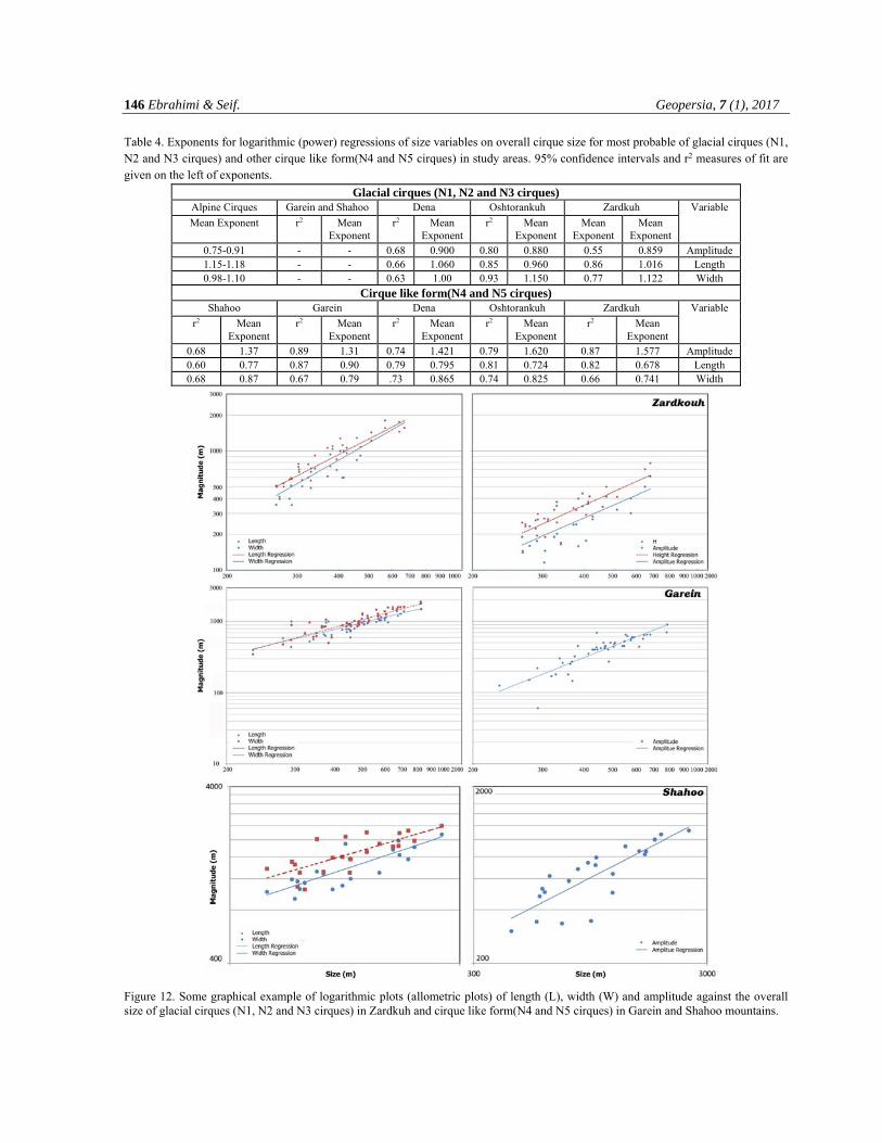
In this study, allometric relationship of length (L), width (W), and amplitude against cirque's size was analyzed based on the method by Evans (2006). Evans (2006) showed that vertical dimension of cirques increases slower than their length and width. The power exponents (gradients of logarithmic regressions) were fitted as the gradients of ordinary least squares regressions of length (L), width (W) and amplitude against size of the glacial cirques (classified as N1, N2 and N3) and cirque like forms (classified as N4 and N5) to check the hypothesis that allometric behaviors of the glacial cirques in Zagros Mountain are similar to the Alpine glacial cirques. Fig. 12 illustrates logarithmic plots of length and width for glacial cirques (N1, N2 and N3 cirques) and cirque like form (N4 and N5 cirques) in Garein and Shahoo as an example. Similar plots for amplitude of the cirques are represented in Fig. 12, too. The mean of exponents of logarithmic regressions for the all size variables (L, W and Amp.) of glacial cirques (N1, N2 and N3 cirques) and cirque like form (N4 and N5 cirques) are represented in Table 3. The coefficient of determination (r2) indicates how well the model fits the data, too (Table 4.).
As a general overview about all the 51 glacial cirques (N1, N2 and N3 cirques) in Zardkuh, Oshtorankuh and Dena, it can be observed that all the size variables increase as overall size increases. The mean of the exponents of amplitude for 51
glacial cirques (N1, N2 and N3 cirques) are from 0.859 to 0.9 and the exponents of length and width are between 0.960 to 1.060 and 1.000 to 1.150, respectively. As can be seen, the amplitude exponents are below 1.0 and the length (L) and width (W) exponents of the glacial cirques are above or very close to 1.0 (Table 4). Indeed, the amplitude of cirques increases at smaller rate than the length (L) and the width (W). It means that the rate of the cirque development in vertical dimensions is smaller than planar dimensions. In addition, the length (L) increases at smaller rate than the width (W). It means that the rate of the cirque development in lateral direction is higher than longitudinal direction and also it is concluded that growth of the glacial cirques (N1, N2 and N3 cirques) in Zagros Mountain has an allometric behavior which is comparable with Alpine glacial cirques (Table 4).
The power functions were also fitted to the length (L), width (W) and amplitude against size of the 136 cirque like form (N4 and N5 cirques) in Zardkuh, Oshtorankuh, Shahoo, Dena and Garein. The mean of the exponents of amplitude for 136 cirque like form are from 1.31 to 1.62 and the exponents of length and width are between 0.678 to 0.9 and 0.74 to 0.87, respectively. As can be seen, the amplitude exponents are above 1.0 and the length (L) and width (W) exponents of the cirque like form are less than 1.0 (Table 4).
146 Ebrahimi & Seif. Geopersia, 7 (1), 2017
Table 4. Exponents for logarithmic (power) regressions of size variables on overall cirque size for most probable of glacial cirques (N1, N2 and N3 cirques) and other cirque like form(N4 and N5 cirques) in study areas. 95% confidence intervals and r2 measures of fit are given on the left of exponents.
Glacial cirques (N1, N2 and N3 cirques) Variable Zardkuh Oshtorankuh Dena Garein and Shahoo Alpine Cirques
Mean Exponent
Mean Exponent
Mean Exponent
r2 Mean Exponent
r2 Mean Exponent
r2 Mean Exponent
Amplitude 0.859 0.55 0.880 0.80 0.900 0.68 - - 0.75-0.91 Length 1.016 0.86 0.960 0.85 1.060 0.66 - - 1.15-1.18 Width 1.122 0.77 1.150 0.93 1.00 0.63 - - 0.98-1.10
Cirque like form(N4 and N5 cirques) Variable Zardkuh Oshtorankuh Dena Garein Shahoo
Mean Exponent
r2 Mean Exponent
r2 Mean Exponent
r2 Mean Exponent
r2 Mean Exponent
r2
Amplitude 1.577 0.87 1.620 0.79 1.421 0.74 1.31 0.89 1.37 0.68 Length 0.678 0.82 0.724 0.81 0.795 0.79 0.90 0.87 0.77 0.60 Width 0.741 0.66 0.825 0.74 0.865 .73 0.79 0.67 0.87 0.68
Figure 12. Some graphical example of logarithmic plots (allometric plots) of length (L), width (W) and amplitude against the overall size of glacial cirques (N1, N2 and N3 cirques) in Zardkuh and cirque like form(N4 and N5 cirques) in Garein and Shahoo mountains.
Morphometric Properties of Glacial Cirques in Zagros Mountain, Iran 147
It can be observed that the allometric behavior of cirque like form are completely different of glacial cirques and is not comparable with Alpine glacial cirques. It means that from allometric behavior point of view, these features couldn't be a real glacial cirque.
As can be clearly seen almost all the glaciers in Zardkuh and Oshtorankuh are located in the glacial cirques (N1, N2 and N3). In addition, it is observed that all the cirques that classified as classic and
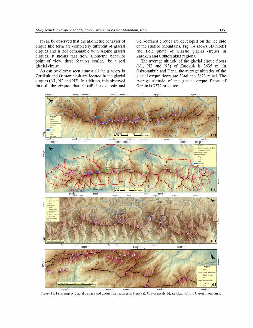
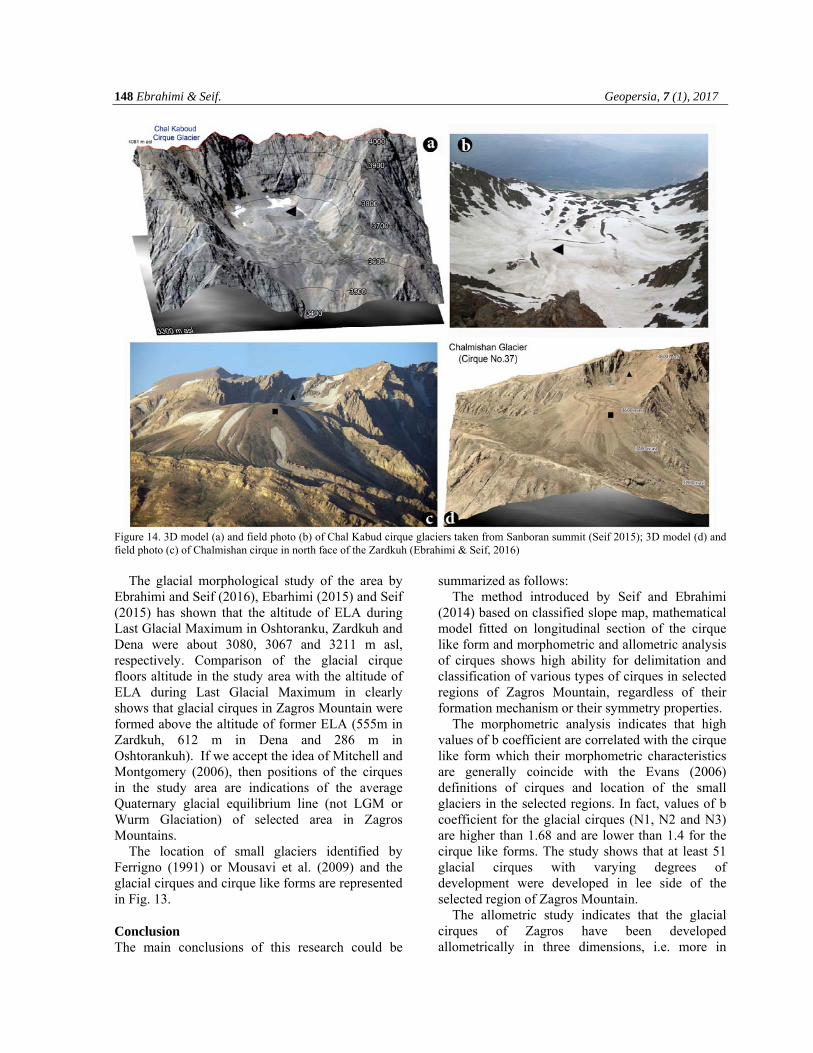
well-defined cirques are developed on the lee side of the studied Mountains. Fig. 14 shows 3D model and field photo of Classic glacial cirques in Zardkuh and Oshtorankuh regions.
The average altitude of the glacial cirque floors (N1, N2 and N3) of Zardkuh is 3635 m. In Oshtorankuh and Dena, the average altitudes of the glacial cirque floors are 3366 and 3823 m asl. The average altitude of the glacial cirque floors of Garein is 3372 masl, too.
Figure 13. Final map of glacial cirques and cirque like features in Dena (a), Oshtorankuh (b), Zardkuh (c) and Garein mountains.
148 Ebrahimi & Seif. Geopersia, 7 (1), 2017
Figure 14. 3D model (a) and field photo (b) of Chal Kabud cirque glaciers taken from Sanboran summit (Seif 2015); 3D model (d) and field photo (c) of Chalmishan cirque in north face of the Zardkuh (Ebrahimi & Seif, 2016)
The glacial morphological study of the area by
Ebrahimi and Seif (2016), Ebarhimi (2015) and Seif (2015) has shown that the altitude of ELA during Last Glacial Maximum in Oshtoranku, Zardkuh and Dena were about 3080, 3067 and 3211 m asl, respectively. Comparison of the glacial cirque floors altitude in the study area with the altitude of ELA during Last Glacial Maximum in clearly shows that glacial cirques in Zagros Mountain were formed above the altitude of former ELA (555m in Zardkuh, 612 m in Dena and 286 m in Oshtorankuh). If we accept the idea of Mitchell and Montgomery (2006), then positions of the cirques in the study area are indications of the average Quaternary glacial equilibrium line (not LGM or Wurm Glaciation) of selected area in Zagros Mountains.
The location of small glaciers identified by Ferrigno (1991) or Mousavi et al. (2009) and the glacial cirques and cirque like forms are represented in Fig. 13. Conclusion The main conclusions of this research could be
summarized as follows: The method introduced by Seif and Ebrahimi
(2014) based on classified slope map, mathematical model fitted on longitudinal section of the cirque like form and morphometric and allometric analysis of cirques shows high ability for delimitation and classification of various types of cirques in selected regions of Zagros Mountain, regardless of their formation mechanism or their symmetry properties.
The morphometric analysis indicates that high values of b coefficient are correlated with the cirque like form which their morphometric characteristics are generally coincide with the Evans (2006) definitions of cirques and location of the small glaciers in the selected regions. In fact, values of b coefficient for the glacial cirques (N1, N2 and N3) are higher than 1.68 and are lower than 1.4 for the cirque like forms. The study shows that at least 51 glacial cirques with varying degrees of development were developed in lee side of the selected region of Zagros Mountain.
The allometric study indicates that the glacial cirques of Zagros have been developed allometrically in three dimensions, i.e. more in
Morphometric Properties of Glacial Cirques in Zagros Mountain, Iran 149
length and width than in altitudinal range. The allometric behavior of 51 glacial cirques in selected region of Zagros Mountain is also the same as the cirques in Wales studied by Evans (2006). This study also indicates that the other 136 cirque like forms have not similar allometric behavior with the glacial cirques in similar researches. In other word, allometric study verified the results of the classification of cirque like forms in Zagros mountain.
The faster development of the cirques in longitudinal direction compared to vertical dimension could be result of the various factors such as the effects of cold stages of the Pleistocene or other morphological processes (Steffanová and Mentlík, 2007). Considering the ELA during Last Glacial Maximum, it seems that the lengthening of the cirques has been affected by colder stages glaciers (while the ELA is lower than altitude of the cirques floors) when the conditions have been appropriate for development of glaciers. Conversely, the broadening and deepening have been much slower.
Result of the study also supported the idea that elevation of the cirque floor does not have a close relationship with ELA during Last Glacial Maximum. In other word, the cirque floor approach for reconstruction of Last Glacial Maximum ELA is not suitable and thus the reconstructed snowline may substantially underestimate the actual snowline depression. Indeed, in many glaciated tropical mountain ranges (such as Zagros Mountain), glaciers expanded beyond cirques to form valley glaciers and ELAs lay below the altitudes of cirques floors (555 m in Zardkuh, 612 m in Dena and 286 m in Oshtorankuh) in these circumstances. Acknowledgements We are highly indebted to University of Isfahan and Isfahan Regional Water Company for their support and providing necessary information regarding the research. Our thanks and appreciations also go to Dr. Pasandi Assistant professor of department of Geology of University of Isfahan for his able guidance and useful suggestions.
References Barr, I.D., Spagnolo, M., 2014. Testing the efficacy of the glacial buzzsaw: insights from the Sredinny Mountains,
Kamchatka. Geomorphology 206: 230–238. Barr, I.D., Spagnolo, M., 2015. Glacial cirques as palaeoenvironmental indicators: Their potential and limitations. Earth-
Science Reviews 151: 48–78 Brocklehurst, S.H., Whipple, K.X., 2002. Glacial erosion and relief production in the Eastern Sierra Nevada, California.
Geomorphology 42: 1-24.
Brook, M.S., Kirkbride, M.P., Brock, B.W., 2006. Cirque development in a steadily uplifting range: rates of erosion and long-term morphometric change in alpine cirques in the Ben Ohau Range, New Zealand. Earth Surface Processes and Landforms 31: 1167-1175.
Darwin, C.R., 1842. Notes on the effects produced by the ancient glaciers of Caernarvon-shire, and on the boulders transported byfloating ice. Lond. Edinb. Dublin Philos. Mag. J. Sci. 21: 180–188.
Delmas, M., Gunnell, Y., Calvet, M., 2015. A critical appraisal of allometric growth among alpine cirques based on multivariate statistics and spatial analysis. Geomorphology 228: 637–652.
Desio, A., 1934. Sull'esistenza di piccoli ghiacciai nella Persia occidentale [Concerning the existence of small glaciers in western Persia]. Bollettino del Comitato Glaciologico Italianao, 14: 39-52.
Ebrahimi, B., Aeif, A., 2016. Equilibrium-Line Altitudes of Late Quaternary Glaciers in the Zardkuh Mountain, Iran. Geopersia 6 (2): 299-322.
Ebrahimi, B. 2015. Investigation and Analysis of Late Quaternary Glacial Landforms in Zagros Mountain, Iran. Ph.D. thesis. University of Isfahan, IRAN.
Evans, I.S., 1972. Inferring process from form: the asymmetry of glaciated mountains. In: Adams, W.P., Helleiner, F.M. (Eds.), International Geography v1, University of Toronto Press, Toronto: 17-19 pp.
Evans, I.S., Cox, N.J., 1974. Geomorphometry and the operational definition of cirques. Area (Institute of British Geographers, IBG, London), 6: 150-153.
Evans, I.S., Cox, N.J., 1995. The form of glacial cirques in the English Lake District, Cumbria. Zeitschrift für Geomorphologie 39: 175–202.
150 Ebrahimi & Seif. Geopersia, 7 (1), 2017
Evans, I.S., 1997. Process and form in the erosion of glaciated mountains. In: Stoddart, D.R. (Ed.), Process and Form in Geomorphology. Routledge, London, 145-174 pp.
Evans, I.S., 2006. Allometric development of glacial cirque form: geological, Relief and regional effects on the cirques of Wales. Geomorphology 80 (3-4): 245-266.
Evans, I.S., 2009. Allometric development of glacial cirques: an application of specific geomorphometry, proceeding of Geomorphology, Zurich, Switzerland, 31 August – 2 September.
Evans, I.S., (2012) Geomorphometry and landform mapping: what is a landform? Geomorphology, 137 (1) : 94–106 Falcon, N.L. 1974. Southern Iran: Zagros Mountains, in A. M. Spencer, ed., Mesozoic-Cenozoic Orogenic Belts. Data for
Orogenic Studies: v. 4, Geological Society of London, Special Publication, p. 199-211 Federici, P.R., Spagnolo M., 2004. Morphometric analysis on the size, shape and areal distribution of glacial cirques in
the Maritime Alps (Western French-Italien Alps). GeografiskaAnnaler, 86 A: 235–248. Ferrigno, J.G., 1988. Glaciers of the Middle East and Africa – Glaciers of Iran., Williams R. S. and Ferrigno: Satellite
atlas of glaciers of the world. 1386-G-2: 31-47. Galibert, G., 1962. Recherches sur les processus d’érosion glaciaires de la Haute Montagne Alpine, Bulletin, Association
des Géographes Françaises 303-304, 8-46. Gastaldi, B., 1873. On the effects of glacier-erosion in Alpine valleys. Q. J. Geol. Soc. 29 (1–2): 396–401. Graf, W.L., 1976. Cirques as Glacier Location, Arctic and Alpine Research. 8 (1): 79-90. Grunert, J., Carls, H.G., Preu, C., 1978. Rezente Ver-gletscherungsspuren in zentraliranischen Hochgebirgen [The
present-day glaciers of the central Iranian high mountains]: Eiszeitalter und Gegenwart, 28: 148-166. Hanson, G., 1924. Reconnaissance between Skeena River and Stewart, British Columbia. Geol. Survey of Canada,
Summary Report for 1923, A: 29-45. Haynes, V.M., 1968. The influence of glacial erosion and rock structure on corries in Scotland. Geogr. Ann. 50 A (4):
221-234. Hughes, P.D., Gibbard, P.L.,Woodward, J.C., 2007. Geological controls on Pleistocene glaci-ation and cirque form in
Greece. Geomorphology 88 (3), 242–253. Johnson, W.D., 1904. The profile of maturity in alpine glacial erosion. Journal of Geology 12: 569-578. Kehl, M., 2009. Quaternary climate change in Iran- The state of knowledge, erdkunde, 16: 1-17. Lewis, W.V., 1938. A melt-water hypothesis of cirque formation. Geological Magazine 75: 249-265. Lewis, W.V., 1940. The function of meltwater in cirque formation. Geographical Review 30: 64-83. Lewis, W.V., 1949. Glacial movement by rotational slipping. Geografiska Annaler 31, 146-158. Lewis, W.V., 1960. The problem of cirque erosion. In: Lewis, W.V. (Ed.), Norwegian Cirque Glaciers. R.G.S. Research
Series, 4, Royal Geographical Society, London, 97-100 pp. Lie, O., Dahl, S.O., Nesje, A., 2003. A theoretical approach to glacier equilibrium-line altitudes using meteorological
data and glacier mass balance records from southern Norway. The Holocene: 13: 365-372. de Martonne, E., (1901) Sur la formation des cirques. Annales de Géographie 10, 10-16. Mitchell, S.G., Montgomery, D.R., 2006. Influence of a glacial buzzsaw on the height and morphology of the Cascade
Range in central Washington State, USA. Quaternary Research 65, 96-107. McQuillan, H., 1969. Small glacier on Zardeh Kuh, Zagros Mountains, Iran: Geographical Journal, 135 (4): 639p. Mîndrescu, M., Evans, I.S., Cox, N.J., 2010. Climatic implications of cirque distribution in the Romanian Carpathians:
palaeowind directions during glacial periods. J. Quat. Sci. 25 (6): 875–888. Mitchell, S.G., Humphries, E.E., 2015. Glacial cirques and the relationship between equilib-rium line altitudes and
mountain range height. Geology 43 (1): 35–38.
Moussavi, M.S., Valadan, Zoej. M.J., Vaziri, F., Sahebi, M.R., Rezaei, Y., 2009. A new glacier inventory of Iran. Annals of Glaciology: 50 (53).
National Cartographic Center of Iran NCC (2010) Digital Elevation Model (DEM) of Shahrekord Block, 10m spatial resolution base on topographic map with scale 1 : 25,000. NCC, Tehran, IRAN.
Olyphant, G.A., 1981. Allometry and cirque evolution. Geological Society of America Bulletin Part I, 92: 679-685. Oskin, M., Burbank, D.W., 2005. Alpine landscape evolution dominated by cirque retreat. Geology 33: 933-936. Pedrami, M., 1982. Pleistocene and Paleo Climate in Iran. Geo, l, Surv, Tehran.
Morphometric Properties of Glacial Cirques in Zagros Mountain, Iran 151
Preu, C., 1984. Die quartäre Vergletscherung der inneren Zardeh-Kuh-Gruppe (Zardeh-Kuh-Massiv), Zagros/Iran. Augsburger Geogr. H. 4. Augsburg.
Principato, S.M., Lee, J.F., 2014. GIS analysis of cirques on Vestfirðir, northwest Iceland: implications for palaeoclimate. Boreas 43: 807–817.
Richter, E., 1900. Geomorphologische Untersuchungen in den Hochalpen. Petermann’s (Geographische) Mitteilungen, Erganzungsband 29: 1-103.
Seif, A., Ebrahimi, B., 2014. Combined Use of GIS and Experimental Functions for the Morphometric Study of Glacial Cirques in Zardkuh Mountain, IRAN. Quaternary International, Volume 353: 236-249.
Seif, A., 2015. Equilibrium-line altitudes of Late Quaternary glaciers in the Oshtorankuh Mountain, Iran. Quaternary International, 374: 126-143.
Steffanova, P., Mentlik, P., 2007. Comparison of morphometric characteristics of cirques in the Bohemian Forest. Silva Gabreta, Vol. 13(3): 191-204.
Strøm, K.M., 1945. Geomorphology of the Rondane area. Norsk Geologisk Tidsskrift, 25: 360-378. Tuck, R., 1935. Asymmetrical topography in high latitudes resulting from alpine glacial erosion. Journal of Geology 43:
530-8. Tyndall, J., 1862. On the conformation of the Alps. Philos. Mag. 24 (160): 169–173. Vilborg, L., 1984. The cirque forms of central Sweden. Geografiska Annaler. Series A, Physical Geography, Vol. 66,
No. 1/2: 41-77. Vilborg, L., 1977. The Cirque Forms of Swedish Lapland. Geografiska Annaler. Series A, Physical Geography, Vol. 59,
No. 3/4: 89-150. White, W.A., 1970. Erosion of cirques. Journal of Geology, 78: 123-6. Wright, H. E., 1962. Pleistocene glaciation in Kurdistan. In: Eiszeitalter u. Gegenwart, 12:131-164. Yamani, M., 2007. Geomorphology of Zardkouh glaciers. Geography Research (Iran), 59: 125-139.