Thessaloniki Association - 30th anniversary publication 2014
2
International Association of Geomorphologists
Regional Conference on Geomorphology
September 19-21, 2019
Athens, Greece
GEOMORPHOLOGY OF CLIMATICALLY AND
ΤECTONICALLY SENSITIVE AREAS
ABSTRACT BOOK
Publ isher : Facu l ty o f Geo l ogy and Geoenv i ronmen t , Na t i ona l
and Kapod i s t r i an Un i ve rs i t y o f A thens , Greece
ISBN 978-960-466-213-5
3
Organizing bodies
The Greek Committee for Geomorphology &
Environment of the Geological Society of
Greece
International Association of
Geomorphologists
In collaboration with
National and Kapodistrian University of
Athens
Aristotle University of Thessaloniki
University of Patras
Hellenic Centre for Marine Research
Harokopio University
4
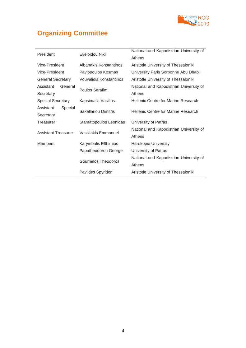
Organizing Committee
President Evelpidou Niki National and Kapodistrian University of
Athens
Vice-President Albanakis Konstantinos Aristotle University of Thessaloniki
Vice-President Pavlopoulos Kosmas University Paris Sorbonne Abu Dhabi
General Secretary Vouvalidis Konstantinos Aristotle University of Thessaloniki
Assistant General
Secretary Poulos Serafim
National and Kapodistrian University of
Athens
Special Secretary Kapsimalis Vasilios Hellenic Centre for Marine Research
Assistant Special
Secretary Sakellariou Dimitris Hellenic Centre for Marine Research
Treasurer Stamatopoulos Leonidas University of Patras
Assistant Treasurer Vassilakis Emmanuel National and Kapodistrian University of
Athens
Members Karymbalis Efthimios Harokopio University
Papatheodorou George University of Patras
Gournelos Theodoros National and Kapodistrian University of
Athens
Pavlides Spyridon Aristotle University of Thessaloniki
5
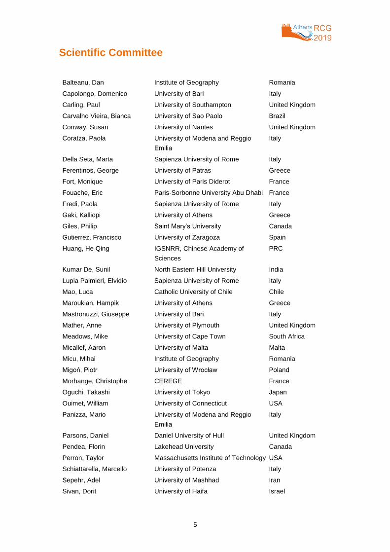
Scientific Committee
Balteanu, Dan Institute of Geography Romania
Capolongo, Domenico University of Bari Italy
Carling, Paul University of Southampton United Kingdom
Carvalho Vieira, Bianca University of Sao Paolo Brazil
Conway, Susan University of Nantes United Kingdom
Coratza, Paola University of Modena and Reggio
Emilia
Italy
Della Seta, Marta Sapienza University of Rome Italy
Ferentinos, George University of Patras Greece
Fort, Monique University of Paris Diderot France
Fouache, Eric Paris-Sorbonne University Abu Dhabi France
Fredi, Paola Sapienza University of Rome Italy
Gaki, Kalliopi University of Athens Greece
Giles, Philip Saint Mary’s University Canada
Gutierrez, Francisco University of Zaragoza Spain
Huang, He Qing IGSNRR, Chinese Academy of
Sciences
PRC
Kumar De, Sunil North Eastern Hill University India
Lupia Palmieri, Elvidio Sapienza University of Rome Italy
Mao, Luca Catholic University of Chile Chile
Maroukian, Hampik University of Athens Greece
Mastronuzzi, Giuseppe University of Bari Italy
Mather, Anne University of Plymouth United Kingdom
Meadows, Mike University of Cape Town South Africa
Micallef, Aaron University of Malta Malta
Micu, Mihai Institute of Geography Romania
Migoń, Piotr University of Wrocław Poland
Morhange, Christophe CEREGE France
Oguchi, Takashi University of Tokyo Japan
Ouimet, William University of Connecticut USA
Panizza, Mario University of Modena and Reggio
Emilia
Italy
Parsons, Daniel Daniel University of Hull United Kingdom
Pendea, Florin Lakehead University Canada
Perron, Taylor Massachusetts Institute of Technology USA
Schiattarella, Marcello University of Potenza Italy
Sepehr, Adel University of Mashhad Iran
Sivan, Dorit University of Haifa Israel

6
Slaymaker, Olav University of British Columbia Canada
Soldati, Mauro University of Modena and Reggio
Emilia
Italy
Urdea, Petru University of Timisoara Romania
Van Der Beek, Peter University Grenoble Alpes France
Vött, Andreas University of Mainz Germany
Zangmo Tefogoum, Ghislain University of Maroua Cameroon
Zouros, Nickolas University of the Aegean Greece
7
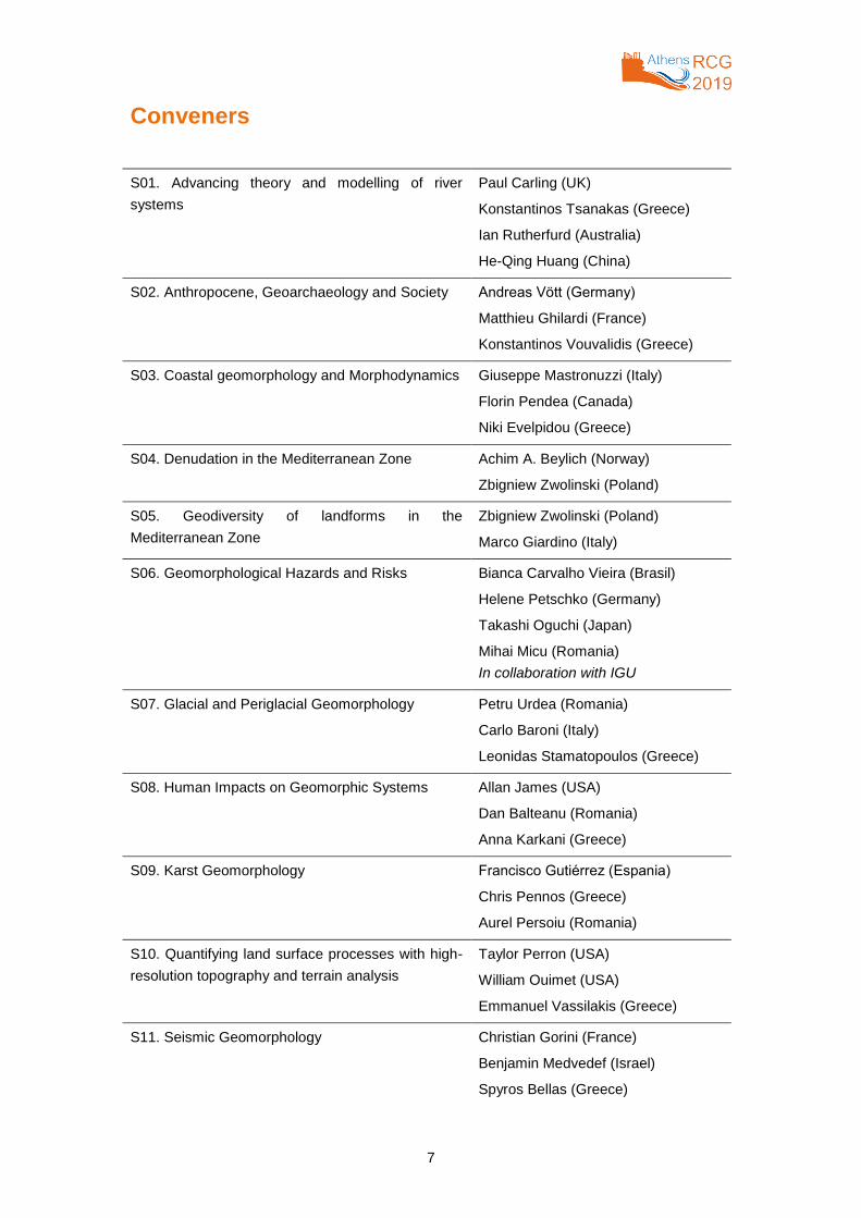
Conveners
S01. Advancing theory and modelling of river
systems
Paul Carling (UK)
Konstantinos Tsanakas (Greece)
Ian Rutherfurd (Australia)
He-Qing Huang (China)
S02. Anthropocene, Geoarchaeology and Society Andreas Vött (Germany)
Matthieu Ghilardi (France)
Konstantinos Vouvalidis (Greece)
S03. Coastal geomorphology and Morphodynamics Giuseppe Mastronuzzi (Italy)
Florin Pendea (Canada)
Niki Evelpidou (Greece)
S04. Denudation in the Mediterranean Zone Achim A. Beylich (Norway)
Zbigniew Zwolinski (Poland)
S05. Geodiversity of landforms in the
Mediterranean Zone
Zbigniew Zwolinski (Poland)
Marco Giardino (Italy)
S06. Geomorphological Hazards and Risks Bianca Carvalho Vieira (Brasil)
Helene Petschko (Germany)
Takashi Oguchi (Japan)
Mihai Micu (Romania)
In collaboration with IGU
S07. Glacial and Periglacial Geomorphology Petru Urdea (Romania)
Carlo Baroni (Italy)
Leonidas Stamatopoulos (Greece)
S08. Human Impacts on Geomorphic Systems Allan James (USA)
Dan Balteanu (Romania)
Anna Karkani (Greece)
S09. Karst Geomorphology Francisco Gutiérrez (Espania)
Chris Pennos (Greece)
Aurel Persoiu (Romania)
S10. Quantifying land surface processes with high-
resolution topography and terrain analysis
Taylor Perron (USA)
William Ouimet (USA)
Emmanuel Vassilakis (Greece)
S11. Seismic Geomorphology Christian Gorini (France)
Benjamin Medvedef (Israel)
Spyros Bellas (Greece)
8
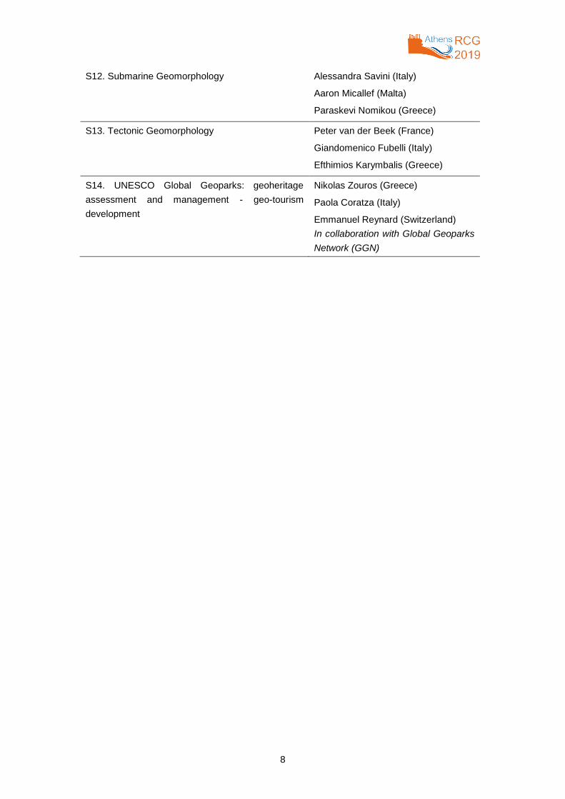
S12. Submarine Geomorphology Alessandra Savini (Italy)
Aaron Micallef (Malta)
Paraskevi Nomikou (Greece)
S13. Tectonic Geomorphology Peter van der Beek (France)
Giandomenico Fubelli (Italy)
Efthimios Karymbalis (Greece)
S14. UNESCO Global Geoparks: geoheritage
assessment and management - geo-tourism
development
Nikolas Zouros (Greece)
Paola Coratza (Italy)
Emmanuel Reynard (Switzerland)
In collaboration with Global Geoparks
Network (GGN)
9
Preface
The Regional Conference on Geomorphology “GEOMORPHOLOGY OF CLIMATICALLY
AND ΤECTONICALLY SENSITIVE AREAS” (RCG2019) was held from 19 to 21 September
2019, in Athens (Greece), at the Historical Building of the National and Kapodistrian
University of Athens. The main objectives of the conference were to a) meet the new
challenges for geoscientists and especially geomorphologists to better understand the
response of the Earth system, b) to approach with new techniques and methods, c) to make
new assessments and predictions for the future, d) to contribute to society’s adaptation and
preparedness, e) to promote interaction and networking among and with young geoscientists.
The abstracts’ volume of this conference includes the 214 abstracts accepted for oral (125)
and poster (89) presentations. The abstracts were distributed in the 14 scientific sessions
covering a variety of geomorphological topics and environments. Four keynote lectures were
delivered during the conference by Dr. Emmanuel Reynard, Dr. Taylor Perron, Dr. Andreas
Vött and Dr. Piotr Migon.
I would like to express my gratitude to the members of the Organizing committee for
dedicating their time to the organization of the conference.
On behalf of the Organizing Committee, I wish to express my warm thanks to the International
Association of Geomorphologists (IAG) and its Executive Committee for putting their trust in
the Greek Committee for Geomorphology & Environment of the Geological Society of Greece.
Niki Evelpidou,
President of the Organizing Committee
Regional Conference on Geomorphology – Athens 2019
10
Contents
S01. ADVANCING THEORY AND MODELING OF RIVER SYSTEMS ................................................. 27
THE PREDICTION AND SPATIAL DISTRIBUTION OF WETLANDS IN ESWATINI (SWAZILAND)............. 28
Jason Le Roux; Heinz Beckedahl; Althea Grundling; Paul Sumner
RESTORATION AND RECONNECTION OF DECAYED RIVERS IN WESTERN GANGES DELTA TO
IMPROVE FRESHWATER AVAILABILITY IN THE INDIAN SUNDARBANS ................................................ 29
Tuhin Bhadra
ANALYSIS OF FLOOD DYNAMICS USING SENTINEL-1 TIME SERIES IN THE BANANAL ISLAND,
BRAZIL ......................................................................................................................................................... 30
Osmar Abílio de Carvalho Júnior; Roberto Arnaldo Trancoso Gomes; Renato Fontes Guimarães; Hugo
Crisóstomo de Castro Filho; Anesmar Olino de Albuquerque
THE “RIVER SCOUR GB” PRODUCT – A GIS SOLUTION TO REINFORCE THE RESILIENCE OF GREAT
BRITAIN ........................................................................................................................................................ 31
Séverine Cornillon; Katy Lee; Russell Lawley
SPATIOTEMPORAL VARIATIONS IN RIPARIAN VEGETATION, ISLAND AND CHANNEL EVOLUTION IN
RESPONSE TO HUMAN PRESSURE: TALEQAN RIVER, IRAN ................................................................. 32
Sahar Darabi Shahmari
PREDICTION OF MONTHLY TIME SERIES OF SUSPENDED SEDIMENTS USING FUZZY SETS ........... 33
Theodoros Gournelos; Vasileios Kotinas; Nikolaos-Artemios Gournelos
RIVER CHANNEL-PLANFORM ADJUSTMENTS: AN EVALUATION OF THE APPLICABILITY OF THE
EQUILIBRIUM THEORY FOR ALLUVIAL RIVERS ....................................................................................... 34
He Qing Huang; Guoan Yu; Teng Su
GEOMORPHOLOGY AND SUSPENDED SEDIMENT TRANSPORT OF THE SECOND LARGEST RIVER
OF SOUTHEAST ASIA: THE IRRAWADDY RIVER, MYANMAR ................................................................. 35
Edgardo M. Latrubesse; Edward Park; Jana S. X. Lim
IMPACT OF CLIMATE CHANGE ON EVAPOTRANSPIRATION IN NORTH CHINA PLAIN ........................ 36
Yujie Liu; Jie Chen; Tao Pan; Quansheng Ge
EVALUATION AND VALIDATION OF CRYOSAT-2-DERIVED WATER LEVELS BY IN-SITU LAKE DATA
FROM CHINA ............................................................................................................................................... 37
Zhaofei Liu; ZhijunYao
THE ROLE OF GROUNDWATER OUTFLOWS IN THE DEVELOPMENT OF CHANNEL HEADS AND
DRAINAGE SYSTEM (POSTGLACIAL AREA IN NW POLAND) .................................................................. 38
Małgorzata Mazurek
SANDSTONE AND CONGLOMERATE LANDFORMS – A (PARTLY) NEGLECTED TOPIC IN
GEOMORPHOLOGY .................................................................................................................................... 39
Piotr Migoń
RELATIVE ACCRETION: A NEW MODEL OF INCISIONAL AVULSION DEVELOPMENT IN LOW-ENERGY
RIVER SYSTEMS ......................................................................................................................................... 40
Ian D Rutherfurd; Abdullah Baky
THE ROLE OF THE NEOTROPICAL DRY-FOREST DYNAMIC OVER NATURAL CHANGES ON
CONNECTIVITY ........................................................................................................................................... 41
Jonas Souza
11
MORPHOLOGICAL ADJUSTMENTS AND PHYSICAL MECHANISM OF THE YINCHUAN PLAIN REACH
OF THE UPPER YELLOW RIVER, CHINA ................................................................................................... 42
Teng Su; He Qing Huang
KEY DRIVING FACTORS OF FLUVIAL PROCESSES IN THE LOWER YARLUNG TSANGPO RIVER ...... 43
Guo-An Yu
S02. ANTHROPOCENE, GEOARCHAEOLOGY AND SOCIETY .......................................................... 44
SALT PANS AS NEW ARCHAEOLOGICAL SEA-LEVEL PROXY, TEST CASE FROM MAKIRINA COVE,
DALMATIA, CROATIA .................................................................................................................................. 45
Benny Bechor; Dorit Sivan; Maja Grisonic; Slobodan Miko; Ozren Hasan; Anna Brook
HUMANS, LANDSCAPES AND SEA-LEVEL CHANGE IN PREHISTORIC CROATIA ................................. 46
Silas Dean; Marta Pappalardo; Giovanni Boschian; Giorgio Spada; Stašo Forenbaher; Mladen Juračić; Igor
Felja; Preston Miracle
LATE HOLOCENE COASTAL DEPOSITIONAL ENVIRONMENTS AND CLIMATE CHANGES IN GULF OF
CORINTH, GREECE ..................................................................................................................................... 47
Alexandros Emmanouilidis; Ingmar Unkel; Maria Triantaphyllou; Pavlos Avramidis1
GEOMORPHOLOGY İN THE ANTHROPOCENE: EXAMPLES FROM ISTANBUL (TURKEY) .................... 48
Topçu Ahmet Ertek
NEW DATA FOR RECONSTRUCTING LANDSCAPE CHANGE IN THE WESTERN MESSARA PLAIN
(PHAISTOS, CRETE, GREECE) FROM THE GEOMETRIC PERIOD TO EARLY BYZANTINE TIMES:
ASSESSING SHIFTS IN THE HUMAN LAND-USE AND THE IMPACT OF CLIMATE CHANGES............... 49
Matthieu Ghilardi; Jordi Revelles; Arthur Glais; Katerina Theodorakopoulou; Tatiana Theodoropoulou;
Laurent Lespez; Fausto Longo; Amedeo Rossi
HUMAN SHAPED LANDSCAPE HISTORY AROUND THE MINOAN TOWN OF MALIA, CRETE: NEW
INSIGHTS ABOUT THE MINOAN CIVILIZATION CONSEQUENCES ON VEGETATION COVER IN THE
LOWLANDS .................................................................................................................................................. 51
Arthur Glais; Julia Haussy; Laurent Lespez; Maia Pomadère; José-Antonio Lopez-Saez; Jean-François
Berger
CURRENT STATE OF GEOMORPHOLOGICAL AND GEOARCHAELOGICAL RESEARCH IN THE
HOLEDNÁ HILL (BRNO, CZECH REPUBLIC) .............................................................................................. 52
Lucie Kubalíková; Karel Kirchner; Josef Unger
RECONSTRUCTION OF CHANGES IN TOPOGRAPHY OF CRACOW CENTRE (POLAND) SINCE THE
9TH CENTURY WITH APPLICATION OF ARCHAEOLOGICAL INFORMATION AND WITH USE OF
ADVANCED GIS TOOLS .............................................................................................................................. 53
Adam Łajczak; Roksana Zarychta
ENVIRONMENTAL CHANGES AT THE BOTTOM OF THE MINOAN TOWN OF MALIA (CRETE):
GEOMORPHOLOGICAL, SEDIMENTOLOGICAL AND MICROFAUNAL EVIDENCES OF LONG-TERM
MARSH DEVELOPMENT AND ABRUPT EVENTS IMPACTS ..................................................................... 54
Laurent Lespez; Séverine Lescure; Arthur Glais; Ségolène Saulnier-Copard; Jean-François Berger; Franck
Lavigne; Maia Pomadere2
THE FORMATION EVOLUTION AND INFLUENCING FACTORS OF THE HONGJIANNAO ....................... 55
Pingxuan Lin
PALEOGEOGRAPHY AND GEOMORPHOLOGICAL EVOLUTION OF AKROTIRI SALT LAKE, LEMESOS,
CYPRUS ....................................................................................................................................................... 56
Miltiadis Polidorou; Niki Evelpidou; Hara Drinia; Theodora Tsourou Ferreol Salomon; Lucy Blue
12
IMPACT OF SEA LEVEL RISE AND ANTHROPOGENIC ACTIVITY ON THREE LAKES FROM THE
LOWER DANUBE FLOODPLAIN IN MIDDLE AND LATE HOLOCENE, ROMANIA ..................................... 57
Laurențiu Țuțuianu; Alfred Vespremeanu-Stroe; Cristian Panaiotu; Tiberiu Sava; Mihaela Dobre; Luminița
Preoteasa
SEDIMENTOLOGICAL VARIABILITY OF THE HOLOCENE DEPOSITIONAL ENVIRONMENT OF
ANTHEMOUNTAS RIVER VALLEY (NORTHERN GREECE) ...................................................................... 58
Konstantinos Vouvalidis; Sofia Doani; Iwona Hildebrandt-Radke; Georgios Syrides
MEASUREMENTS OF THERMIC DAMAGE OF ANGKOR DIMENSION SANDSTONE USED FOR WORLD
HERITAGE TEMPLES .................................................................................................................................. 59
Tetsuya Waragai
S03. COASTAL GEOMORPHOLOGY AND MORPHODYNAMICS ...................................................... 60
HOLOCENE RELATIVE SEA-LEVEL CHANGES ALONG THE SOUTHERN SHORE OF THE ARABIAN
GULF: A REVIEW ......................................................................................................................................... 61
Damien Arhan; Kosmas Pavlopoulos; Eric Fouache
RECONSTRUCTING THE RELATIVE SEA LEVEL AND THE PALEO-SHORELINE DURING THE 1ST
CENTURY BC IN THE UNSTABLE CAMPI FLEGREI CALDERA (SOUTHERN ITALY) .............................. 62
Pietro P.C. Aucelli; Claudia Caporizzo; Aldo Cinque; Gaia Mattei; Gerardo Pappone; Michele Stefanile
GEOMORPHOLOGICAL EVOLUTION OF DOÑA BLANCA (BAY OF CÁDIZ, SPAIN) COASTAL AREA
SINCE THE VIII CENTURY BC (PHOENICIAN TIMES): NATURAL AND ANTHROPOGENIC FORCING ... 63
Claudia Caporizzo; Francisco Javier Gracia; Pietro P.C. Aucelli; Carlos Alonso; Luis Barbero; José Antonio
Ruiz; Lázaro Lagostena
LAND-SEA DATA CORRELATION FROM THE MT. MASSICO COASTAL ZONE, ITALY: SEISMIC VS
LLOG DATA INTERPRETATION .................................................................................................................. 64
Vincenzo Amato; Pietro Aucelli; Giuseppe Corrado; Paola Di Leo; Gerardo Pappone; Marcello Schiattarella
COASTAL EROSION ALONG THE MOLISE COAST (SOUTHERN ITALY): INVESTIGATING THE
POSSIBLE ROLE OF HARD DEFENSE STRUCTURES .............................................................................. 65
Gianluigi Di Paola; Mariano Buccino; Margherita C Ciccaglione; Carmen M Rosskopf
AUTOMATIC COASTLINE EXTRACTION TOOL (CET) BASED ON VERY-HIGH RESOLUTION
WORLDVIEW SATELLITE IMAGERY .......................................................................................................... 66
Fran Domazetović; Ante Šiljeg; Nina Lončar; Ivan Marić; Mirko Barada
EASTERN MEDITERRANEAN CLIMATE VARIABILITY AND RECONSTRUCTION OVER THE LAST 12000
YEARS BASED ON A VARVED SEDIMENT RECORD FROM VOULIAGMENI LAKE, GULF OF CORINTH
(GREECE) .................................................................................................................................................... 67
Alexandros Emmanouilidis; Ingmar Unkel; Pavlos Avramidis
BOULDER DEPOSITS ON THE SOUTHEASTERN COAST OF CYPRUS AND THEIR RELATION WITH
PALEOTSUNAMI EVENTS OF THE EASTERN MEDITERRANEAN ........................................................... 68
Niki Evelpidou; Costas Synolakis; Christos Zerefos; Christos Repapis; Anna Karkani; Miltiadis Polidorou;
Ioannis Saitis
MONITORING COASTAL KARST TOPOGRAPHY AND ITS CHANGE USING HIGH SPATIO- TEMPORAL
RESOLUTION UAV PHOTOGRAMMETRY IN KRAKAL COASTAL AREA, YOGYAKARTA, INDONESIA .. 69
Hendy Fatchurohman; Muh Aris Marfai; Kasimir Orlowsky
CLOSE RANGE PHOTOGRAMMETRY AT TIDAL AND NEAR-TIDAL ZONE .............................................. 70
Stefano Furlani; Vanja Macovaz; Valeria Vaccher
LONGSHORE DRIFT CONVERGENCE IN EMBAYMENTS ......................................................................... 71
13
Junia Kacenelenbogen Guimarães; Paulo James de Oliveira; José Maria Landim Dominguez
A COMPARATIVE STUDY OF SEASONAL CHANGES OF THE SEDIMENTOLOGICAL AND
GEOMORPHOLOGICAL CHARACTERISTICS OF MYLOPOTAS AND MANGANARI BEACH IN IOS
ISLAND, CYCLADES (GREECE) ................................................................................................................. 72
Apostolia Komi; Alexandros Petropoulos; Niki Evelpidou; Serafim Poulos; Vassilios Kapsimalis
THE ROLE OF THE WAVE REGIME IN BEACH ZONE MORPHOLOGICAL CHANGES: AN EXAMPLE
FROM THE NORTHERN COAST OF MESSINIAKOS GULF (IONIAN SEA) ................................................ 73
Sylvia-Vasiliki Koumpou; Fragiska-Carmella Gad; Maria Hatzaki; Stelios Petrakis; Aikaterini Karditsa;
Vassilios Kapsimalis; Serafim Poulos
DETERMINATION OF TSUNAMI EVACUATION ROUTE BASED ON DETAILED DIGITAL ELEVATION
MODEL IN GUNUNGKIDUL COASTAL AREA, JAVA, INDONESIA ............................................................. 74
Muh Aris Marfai; Hendy Fatchurohman
IMPACT OF COASTAL STRUCTURES ON SHORELINE BEHAVIOUR – A CASE STUDY FROM SW
COAST OF INDIA ......................................................................................................................................... 75
Vipin J. Markose; G.S. Dwarakish
THE COASTAL MORPHOEVOLUTION OF NAPLES SINCE 6000 YEARS BP: NEW INSIGHTS FOR
PIZZOFALCONE PROMONTORY ................................................................................................................ 76
Pietro P.C. Aucelli; Claudia Caporizzo; Gaia Mattei; Gerardo Pappone
AGE EVOLUTION AND GEOMORPHIC DEVELOPMENT OF AKROTIRI PROMONTORY SAND DUNES,
CYPRUS ....................................................................................................................................................... 77
Miltiadis Polidorou; Niki Evelpidou
NEARSHORE SEDIMENT DYNAMICS IN RELATION TO COASTAL EVOLUTION: SATELLITE
RETRIEVALS AND IN-SITU MEASUREMENTS IN THE GULF OF ALEXANDROUPOLIS .......................... 78
Aikaterini Karditsa; Athina Tsapanou; Serafeim Poulos
A COMPARATIVE STUDY OF BEACHROCK MECHANISM FOR-MATION FOCUSING ON NATURAL AND
ARTIFICIAL BEACHROCKS: CASE OF DIOLKOS, CORINTH, GREECE AND SU-MUIDE, OKINAWA,
JAPAN .......................................................................................................................................................... 79
Giannis Saitis; Eleni Koutsopoulou; Niki Evelpidou; Satoru Kawasaki
BEACHROCK FORMATION MECHANISM THROUGH MINEROCHEMICAL ANALYSIS AND CEMENT
CHARACTERISTICS: CASE STUDY W. AKROTIRI PENINSULA, CYPRUS .............................................. 80
Giannis Saitis; Miltiadis Polidorou; Niki Evelpidou
BIOTURBATION VIS-À-VIS SEDIMENT DISPERSAL IN A RETROGRADATIONAL DELTA: SAGAR
ISLAND, HUGLI ESTUARY, INDIA ............................................................................................................... 81
Pritam Kumar Santra; Abhijit Chakraborty; Sunando Bandyopadhyay
COASTAL VULNERABILITY ASSESSMENT ALONG THE NORTH-EASTERN SECTOR OF GOZO ISLAND
(MALTA, MEDITERRANEAN SEA) ............................................................................................................... 82
Anton S. Micallef; George Buhagiar; Angela Rizzo; Vittoria Vandelli; Mauro Soldati
USING SATELLITE IMAGES TO DETECT UNDERWATER FEATURES ALONG DANUBE DELTA UPPER
SHOREFACE ................................................................................................................................................ 83
Florin Tătui; Sorin Constantin
ROCK FALLS AND CLIFF RETREAT RATES IN PYROCLASTIC SLOPES: THE CASE STUDY OF THE
PHLEGREAN COAST (SOUTHERN ITALY) ................................................................................................. 84
Ettore Valente; Melania De Falco; Giovanni Forte; Nicoletta Santangelo; Antonio Santo
14
ASSESSING THE COASTAL VULNERABILITY DERIVED FROM BOTH NATURAL AND
ANTHROPOGENIC PROCESSES, ESTIMATING CVI AND TVI AT TOURISM DESTINATIONS: THE CASE
OF RHODES ISLAND, GREECE .................................................................................................................. 85
Dimitris Vandarakis; Kalliopi Kyriakou; Vasiliki Loukaidi; Aikaterini Kikaki; Fragiska-Carmella Gad; Chara
Kyriakidou; Evanggelos Sourianos; Vassilios Kapsimalis; Paraskevi Drakopoulou; Georgios-Angelos Hatiris;
Ioannis Panagiotopoulos; Maria Chatzinaki; Ioannis Morfis; Andreas Sioulas; Theodore Kanellopoulos;
Isidoros Livanos
COASTAL EVOLUTION OF THE TWO NATURAL RESERVES OF THE TIDELESS BLACK SEA AND
BALTIC SEA: SIMILARITIES, DISCORDANCES AND CYCLIC ALTERNATING EVOLUTIONARY TRENDS
...................................................................................................................................................................... 86
Alfred Vespremeanu-Stroe; Marius Pîrvan; Florin Tătui; Florin Zăinescu
PALEOECOLOGICAL TRACERS OF MARINE-FRESHWATER TRANSITIONS DURING THE EARLY TO
MID HOLOCENE DANUBE DELTA BUILD-UP ............................................................................................. 87
Florin Pendea; Alfred Vespremeanu-Stroe; Sabin Rotaru; Laurențiu Țuțuianu; Diana Hanganu; Luminița
Preoteasa
S04. DENUDATION IN THE MEDITERRANEAN ZONE ........................................................................ 88
DRIVERS AND RATES OF DENUDATIONAL PROCESSES AND SOURCE-TO-SINK FLUXES UNDER
CHANGING CLIMATE AND ANTHROPOGENIC IMPACTS IN SELECTED MEDITERRANEAN
CATCHMENT SYSTEMS IN EASTERN SPAIN ............................................................................................ 89
Achim A. Beylich; Katja Laute
THE IAG WORKING GROUP ON DENUDATION AND ENVIRONMENTAL CHANGES IN DIFFERENT
MORPHOCLIMATIC ZONES (DENUCHANGE, 2017-2021): OBJECTIVE, ACTIVITIES AND PLANNED
OUTCOME .................................................................................................................................................... 90
Achim A. Beylich; DENUCHANGE Team
SOIL EROSION AND DEPOSITION RATE INSIDE AN ARTIFICIAL RESERVOIR IN THE SAN ROCCO
WATERSHED, ITALY: BATHYMETRY AGAINST RUSLE ........................................................................... 91
Margherita Bufalini; Marco Materazzi; Gilberto Pambianchi; Artemi Cerdà; Emy Fuffa; Michele Tromboni
OBJECT-BASED MAPPING OF GULLY EROSION IN KARSTIC AREA THROUGH THE USE OF MEDIUM
SPATIAL RESOLUTION MORPHOMETRIC PARAMETERS ....................................................................... 92
Fran Domazetović; Nina Lončar; Ante Šiljeg
ASSESSING RIVER’S RELATIVE SEDIMENT DISCHARGE DELIVERY USING MODIS IMAGERY .......... 93
Sotirios E. Karalis; Efthimios Karymbalis
QUATERNARY DENUDATION RATES CALCULATED FROM TUFA DEPOSITS SHELTERED BY INLAND
NOTCHES, MT. CARMEL, ISRAEL .............................................................................................................. 94
Nurit Shtober-Zisu; Anton Vaks; Amos Frumkin
S05. GEODIVERSITY OF LANDFORMS IN THE MEDITERRANEAN ZONE ....................................... 95
GEOMORPHODIVERSITY, SEDIMENT AND SOIL DYNAMICS, AND RELATED CONTROL FACTORS:
MULTISCALE INVESTIGATION IN SELECTED HYDROGRAPHIC BASINS IN THE VEGLIA-DEVERO
NATURAL PARK........................................................................................................................................... 96
Irene Maria Bollati; Anna Masseroli; Manuela Pelfini
THE GEODIVERSITY OF MOUNTAIN KARST LANDSCAPES: EXAMPLES FROM THE CENTRAL-
SOUTHERN APENNINES ............................................................................................................................ 97
Francesca Filocamo; Gianluigi Di Paola; Carmen M. Rosskopf
COASTAL SYSTEMS AND THEIR IMPACT ON MANGROVE ASSEMBLAGES ......................................... 98
15
Enas Farghaly; Seham Hashem; Samia Moheb; Ahmed Khalafallah; El Sayed Abd El Azez; Nora Abd El
Tawaab
LANDFORM AND GEODIVERSITY ANALYSIS OF PALE MUNICIPALITY (BOSNIA AND HERZEGOVINA)
USING TOPOGRAPHIC POSITION INDEX .................................................................................................. 99
Jelena Golijanin
THE GEODIVERSITY OF SELECTED MEDITERRANEAN ISLANDS ........................................................ 100
Zbigniew Zwoliński; Alicja Najwer
S06. GEOMORPHOLOGICAL HAZARDS AND RISKS ...................................................................... 101
RISKS OF LANDSLIDES IN SALVADOR, BAHIA (BRAZIL): THE RELATIONSHIP BETWEEN THE
ENVIRONMENTAL SUSCEPTIBILITY AND SOCIAL VULNERABILITY ..................................................... 102
Grace B. Alves; Jilvana Souza; Laís Silva; Jessica Santana; Paulo Zangalli Junior
NEW CONTRIBUTIONS TO THE ANALYSIS OF THE GEOMORPHOLOGICAL AND GEOLOGICAL
VULNERABILITY OF THE ROMAN EDIFICE WITH MOSAIC SITE, CONSTANTA ................................... 103
Andreea Andra-Toparceanu; Verga Mihaela; Mihai Mafteiu
A NEW APPROACH FOR THE ANATIONAL-SCALE LANDSLIDE SUSCEPTIBILITY MAP IN ROMANIA IN
A EUROPEAN METHODOLOGICAL FRAMEWORK .................................................................................. 104
Dan Bălteanu; Mihai Micu; Marta Jurchescu; Jean-Philippe Malet; Mihaela Sima; Gheorghe Kucsicsa;
Cristina Dumitrică; Dănuţ Petrea; Ciprian Mărgărint; Ştefan Bilaşco; Cornelia Dobrescu; Elena Călăraşu;
Ioan Boți; Ernest Olinic; Francisc Senzaconi
ASSESSMENT OF BANK LINE DYNAMICS OF RIVER GANGA AND ITS IMPACT ON LAND USE
PRACTICES USING LANDSCAPE METRICS IN MALDA DISTRICT, WEST BENGAL, INDIA .................. 105
Nilanjana Biswas; Soma Bhattacharya
LARGE LANDSLIDES AND DEEP-SEATED GRAVITATIONAL SLOPE DEFORMATIONS IN THE CZECH
OUTER WESTERN CARPATHIANS .......................................................................................................... 106
Michal Břežný; Tomáš Pánek; Veronika Smolková; Jan Lenart; Vladimír Chalupa
GEOLOGICAL AND TOPOGRAPHIC CONDITIONING FACTORS OF SHALLOW LANDSLIDES IN SÃO
LUIZ DO PARAITINGA COUNTY, BRAZIL ................................................................................................. 107
José Bonini; Jurandyr Luciano Sanches Ross; Tiago Damas Martins; Bianca Carvalho Vieira
THE INFLUENCE OF THE GEOMORPHOLOGICAL AND PEDOLOGICAL PROPERTIES ON LANDSLIDES
IN THE SERRA DO MAR MOUNTAIN RANGE, BRAZIL ............................................................................ 108
Bianca Carvalho Vieira; Rebeca Durço Coelho; José Bonini; Maria Carolina Villaça Gomes; Marcelo Fischer
Gramani; Vivian Cristina Dias
DEEP SEATED LANDSLIDES ON FLYSCH NAPPE OUTLIERS ............................................................... 109
Vladimír Chalupa
THE IMPLICATION OF DEM RESOLUTION ON SLOPE INSTABILITY MODELLING ............................... 110
Tiago D. Martins; Bianca Carvalho Vieira; Carlos Bateira
FLOOD AS AN ANTHROPOGENIC HAZARD: CASE STUDY OF THE 2016 FLOOD OF BIHAR, INDIA .. 111
Abhijit Das; Pritam Kumar Santra; Sunando Bandyopadhyay
INHERITED AND MODERN SLOPE PROCESSES IN NUNAVIK: FROM HAZARDS TO RISK SITUATIONS
.................................................................................................................................................................... 112
Armelle Decaulne; Najat Bhiry Samuel Veilleux2
TREE-RING RECONSTRUCTION OF SNOW-AVALANCHE ACTIVITY IN MARAMUREŞ MOUNTAINS
(EASTERN CARPATHIANS, ROMANIA) .................................................................................................... 113
16
Armelle Decaulne; Mihai Hotea; Cosmin Timofte; Iulian Holobâcă; Ionela Georgiana Răchită; Olimpiu Traian
Pop
A MULTIDISCIPLINARY APPROACH FOR INVESTIGATIONS OF THE DYNAMICS OF A BOULDER
DEPOSIT ON A LOW-LYING ROCKY PROMONTORY IN THE NORTHERN ADRIATIC SEA .................. 114
Stefano Devoto; Sara Biolchi; Linley Hastewell; Matteo Mantovani; Giovanni Scicchitano; Tvrtko Korbar; Ivica
Vilibić; Clea Denamiel; Stefano Furlani
NATURAL HAZARDS TRIGGERED BY THE INTENSE 2018 MONSOON IN THE KALI GANDAKI VALLEY,
NEPAL HIMALAYA ..................................................................................................................................... 115
Monique Fort; Rainer Bell; Joachim Götz; Heidi Bernsteiner; Jürgen Etzlstorfer; Eva Posch; Narayan Gurung;
Jean-Claude Bergès
CONSTRUCTION OF ROAD AND BRIDGES IN NEPAL HIMALAYA WITH POOR CONSIDERATION OF
NATURAL HAZARDS ................................................................................................................................. 116
Narayan Gurung; Gilles Arnaud Fassetta; Monique Fort
ASSESSMENT OF ROLE OF BIG DAMS AND WEATHER EXTREME IN 2017 FLOOD OF SOUTHEN
BENGAL, INDIA .......................................................................................................................................... 117
Kapil Ghosh; Sunil Kumar De
DEBRIS FLOWS AND LONG-TERM DENUDATION RATES IN THE SERRA DO MAR/SP, BRAZIL ........ 118
Maria Carolina Villaça Gomes
A DYNAMIC EROSION SUSCEPTIBILITY MODEL USING COMBINED FUZZY SETS AND LOGISTIC
REGRESSION ............................................................................................................................................ 119
Theodoros Gournelos; Niki Evelpidou; Vasileios Kotinas
STUDY ON THE SEDIMENTARY ENVIRONMENT OF LUOHE FORMATION OF EARLY CRETACEOUS
BETWEEN ZHIDAN AND SHENMU COUNTIES IN SHAANXI PROVINCE AND ITS RELATIONSHIP WITH
DANXIA LANDFORM IN NORTHERN SHAANXI........................................................................................ 120
Wu Hao
KINEMATIC ANALYSIS OF SEA CLIFF STABILITY USING UAV PHOTOGRAMMETRY.......................... 121
Ignacio Ibarra; John Barlow; Roger Moore
HIKING TRAILS ASSESSMENT USING DENDROGEOMORPHOLOGICAL APPROACH AND
TOPOGRAPHIC PARAMETERS. CASE STUDY: BUCEGI MOUNTAINS-SOUTHERN CARPATHIANS,
ROMANIAN CARPATHIANS ...................................................................................................................... 122
Mihai Jula; Mircea Voiculescu
DAM FAILURE AND A CATASTROPHIC FLOOD IN THE MEKONG BASIN (BOLAVEN PLATEAU), LAOS,
2018 ............................................................................................................................................................ 123
Edgardo Latrubesse, Edward Park; Kerry Sieh; Thanh Dang; Yunung Nina Lin; Sang-Ho Yun
EXPERIMENTAL FIELD STUDY ON THE FATIGUE AND FAILURE MECHANISMS OF COASTAL CHALK
CLIFFS: IMPLEMENTATION OF A MULTI-PARAMETER MONITORING IN SAINTE-MARGUERITE-SUR-
MER (SEINE-MARITIME, FRANCE) ........................................................................................................... 124
Nicolas Le Dantec; Pauline Letortu; Emmanuel Augereau; Stéphane Costa; Olivier Maquaire; Robert
Davidson; Ali Saab; Augustin Sallent; Laurent Longuevergne; Jérôme de la Bernardie; Olivier Bour;
Christophe Delacourt
COMBINING LANDSLIDE SUSCEPTIBILITY WITH POTENTIAL RUNOUT: AN INTEGRATIVE APPROACH
COMBINING DATA-DRIVEN METHODS.................................................................................................... 125
Pedro Lima; Stefan Steger; Thomas Glade; Martin Mergili
17
A COMBINATION OF NUMERICAL MODELS FOR FALL AND FLOW TO SIMULATE COMPLEX
LANDSLIDES .............................................................................................................................................. 126
Nina Marlovits; Thomas Glade; Alexander Preh; Emmanouil Fleris; Martin Mergili
IMPROVING LANDSLIDE SUSCEPTIBILITY MODEL ACCURACY THROUGH MULTIPLE NESTED MARS
ANALYSIS: APPLICATION IN THE ILOPANGO CALDERA AREA (EL SALVADOR, C.A.)........................ 127
Chiara Martinello; Edoardo Rotigliano; Christian Conoscenti
THE LITHOLOGIC CHARACTERISTIC AND PALAEOGEOGRAPHIC SIGNIFICANCE OF
ANEMOARENYTE OF ORDOS BASIN IN EARLY CRETACEOUS LUOHE FORMATION ........................ 128
Tian Minmin
USE OF MULTI-TEMPORAL SAR AMPLITUDE IMAGES FOR RAPID LANDSLIDES DETECTION ......... 129
Alessandro Mondini
PALEO-TSUNAMI ALONG THE WEST COAST OF SUMBAWA, INDONESIA: A PRELIMINARY STUDY 130
Bachtiar W. Mutaqin; Franck Lavigne; Patrick Wassmer; Martine Trautmann; Jean-Christophe Komorowski;
Junun Sartohadi; Bagus Septiangga; Arum Puspitorukmi
GEOMORPHOLOGICAL CHARACTERISTICS AND THE IMPACT OF GEOLOGICAL HAZARDS OF
LOESS PLATEAU IN NORTHERN SHAANXI, CHINA ................................................................................ 131
Kuibin Ning
GEOMORPHOLOGICAL APPLICATIONS TO NATURAL HAZARDS IN JAPAN AND TAIWAN ................ 132
Takashi Oguchi; Chi-wen Chen; Hongey Chen
LOCATIONS OF HISTORICAL AND ARCHAEOLOGICAL MONUMENTS IN JAPAN AND CHINA IN
RELATION TO GEOMORPHOLOGY AND NATURAL HAZARDS.............................................................. 133
Yuan Wang; Takashi Oguchi
GULLY-LANDSLIDE EVOLUTION FROM 2009 TO PRESENT: A CASE STUDY FROM SOUTHEAST
NIGERIA ..................................................................................................................................................... 134
Ikenna Osumgborogwu; John Wainwright; Laura Turnbull-Lloyd
GIANT LANDSLIDES AND FALL OF GLACIAL LAKES IN THE FORELAND OF THE PATAGONIAN ICE
SHEET ........................................................................................................................................................ 135
Tomáš Pánek; Elisabeth Schönfeldt; Diego Winocur; Karel Šilhán; Vladimír Chalupa; Oliver Korup
OLD BUT STILL ACTIVE: >18 KA HISTORY OF ROCK-SLOPE FAILURES AFFECTING FLYSCH
ANTICLINE ................................................................................................................................................. 136
Tomáš Pánek; Michal Břežný; Règis Braucher; Karel Šilhán; Vladimír Chalupa; Jan Lenart
RELATIONSHIPS BETWEEN LAND-USE LEGACIES AND LANDSLIDE OCCURRENCE ........................ 137
Raphael Knevels; Helene Petschko; Alexander Brenning; Herwig Proske; Philip Leopold; Gerhard Heiss;
Wolfgang Loibl; Mario Köstl; Christian Stefan; Simone Gingrich; Christoph Plutzar; Theresia Lechner; Willi
Haas
INTEGRATING PIXEL ANALYSIS INTO SLOPE UNITS LANDSLIDE SUSCEPTIBILITY MAPPING: AN
APPLICATION TO THE IMERA RIVER BASIN (NORTHERN SICILY, ITALY) ........................................... 138
Edoardo Rotigliano; Chiara Martinello; Chiara Cappadonia; Valerio Agnesi
MORE FREQUENT DEBRIS FLOWS IN SOUTHEAST AUSTRALIA LINKED TO DROUGHT, WILDFIRE,
AND THE EL NIÑO–SOUTHERN OSCILLATION ....................................................................................... 139
Petter Nyman; Ian D. Rutherfurd; Patrick N.J. Lane; Gary J. Sheridan
VIDEO EDITING AND UAV SURVEY TECHNIQUES USEFUL FOR THE ANALYSES OF BOULDER
MOVEMENTS OCCURRED DURING THE STROKE OF MEDICANE “ZORBAS” ON SOUTHEASTERN
SICILY ........................................................................................................................................................ 140
18
Giovanni Scicchitano; Giovanni Scardino; Sebastiano Tarascio; Carmelo Monaco; Giovanni Barracane;
Giuseppe Locuratolo; Maurilio Milella; Arcangelo Piscitelli; Giuseppe Mastronuzzi
UNDERSTANDING THE DESERTIFICATION PROCESSES AND ROLE OF NATURAL AND
ANTHROPOGENIC DRIVERS IN AN ARID ECOSYSTEM: A CASE STUDY IN INDIAN ARID LANDS ..... 141
Azizur Rahman Siddiqui
GEOMORPHOLOGY AND DISASTER RISK REDUCTION: THE EXPERIENCE OF THE EMTASK
ACADEMIC UPGRADING COURSE ON TERRITORIAL, ENVIRONMENTAL AND HEALTH
EMERGENCIES ......................................................................................................................................... 142
Mauro Soldati; Alessandro Ghinoi; Simona Marchetti Dori
CONSEQUENCES OF MASS MOVEMENTS RELATED TO ANCIENT EXTRACTIVE ACTIVITIES IN THE
CITY OF TANDIL, ARGENTINA ................................................................................................................. 143
Rodolfo Osvaldo Gentile; Juan Manuel Susena
TESTING OF DENDROGEOMORPHIC METHODS ON MONITORED LANDSLIDES: HOW EFFECTIVE IS
DENDROGEOMORPHIC DATING FOR THE IDENTIFICATION OF LANDSLIDE ACTIVITY? .................. 144
Karel Šilhán; Radek Tichavský; Jan Klimeš; Roberta Prokešová; Alžbeta Medveďová
MODELLING PEAK DISCHARGE WITH THE USE OF UNMANNED AIRCRAFT SYSTEMS. THE CASE OF
MARIOREMA STREAM DURING THE FLASH FLOOD OF 2016 (LAKONIA, GREECE) ........................... 145
Konstantina Tsaprouni; Emmanuel Andreadakis; Mihalis Diakakis
MASS MOVEMENTS STUDY IN DJOUNDÉ LOCALITIY AND VICINITIES (MAROUA II SUB- DIVISION,
FAR-NORTH, CAMEROON) ....................................................................................................................... 146
Mfossi Amza; Ghislain Zangmo Tefogoum; Merlin Gountié Dedzo; David Guimolaire Nkouathio; Armand
Kagou Dongmo; Marcelin Bikoro Bi Alou
S07. GLACIAL AND PERIGLACIAL GEOMORPHOLOGY................................................................. 147
THERMOKARST DEGRADATION: LARGE-SCALE LABORATORY SIMULATION ................................... 148
François Costard; Antoine Séjourné; Frédéric Bouchard; Alexander Fedorov; Laure Dupeyrat; Bertrand
Saint- Bezar; Chiara Mamo
THE COMPLEX READJUSTMENT OF A PERIGLACIAL RIVER TO ONGOING CLIMATE CHANGE, THE
LENA RIVER (EASTERN SIBERIA) ............................................................................................................ 149
Emmanuèle Gautier; Julien Cavero; Thomas Depret; Maël Jammet; Clément Pont; Nicolas Delbart; François
Costard; Clélia Bilodeau; Clément Virmoux
GLACIAL DECLINE IN THE GRAN PARADISO MASSIF (WESTERN ITALIAN ALPS) SINCE THE LITTLE
ICE AGE: QUANTITATIVE ANALYSIS FROM A MULTITEMPORAL DATABASE...................................... 150
Simona Gennaro; Maria Cristina Salvatore; Carlo Baroni
SOILS DYNAMIC, PARENT MATERIAL EFFECT AND GEOMORPHOLOGICAL PROCESSES IN HIGH
MOUNTAIN ENVIRONMENTS: THE CASE OF RIO BUSCAGNA HYDROGRAPHIC BASIN (VEGLIA-
DEVERO NATURAL PARK, CENTRAL-WESTERN ITALIAN ALPS) .......................................................... 151
Anna Masseroli; Irene Bollati; Manuela Pelfini; Luca Trombino
GEOMORPHIC PARAMETERS OF SEDIMENT SOURCES INFLUENCING THE MONOLITH AND KELLER
STREAMS, JAMES ROSS ISLAND, ANTARCTICA ................................................................................... 152
Lenka Ondráčková; Radim Stuchlík; Daniel Nývlt
QUATERNARY GLACIAL LANDFORMS ON PERISTERI AND TZOUMERKA MASSIFS (PINDOS CHAIN,
NORTHWESTERN GREECE) .................................................................................................................... 153
Leonidas Stamatopoulos; Konstantinos Vouvalidis
19
THE ROCK GLACIERS ON THE BULGARIAN HIGHEST MOUNTAINS (RILA & PIRIN) AND RETEZAT
MOUNTAINS, ROMANIA: A COMPARATIVE ANALYSIS .......................................................................... 154
Petru Urdea; Brigitte Magori; Alexandru Onaca; Florina Ardelean
DISTRIBUTION AND TIMING OF LAST GLACIAL PATTERNED GROUND IN THE CZECH REPUBLIC.. 155
Tomáš Uxa; Marek Křížek; David Krause; Zbyněk Engel; Piotr Moska; Règis Braucher; Aster Team
THE LATE PLEISTOCENE GLACIAL HISTORY OF THE ALTA BADIA VALLEY (DOLOMITES, ITALY) .. 156
Vittoria Vandelli; Carlo Baroni; Mauro Marchetti; Maria Cristina Salvatore; Mauro Soldati
S08. HUMAN IMPACTS ON GEOMORPHIC SYSTEMS ..................................................................... 157
IMPACT OF HUMAN INTERVENTION ON AGGRAVATING FLUVIAL HAZARDS: A CASE STUDY ALONG
A PART OF NAGAVALI RIVER IN RAYAGADA DISTRICT, ORISSA ......................................................... 158
Shreya Bandyopadhyay; Sunil Kumar De
MOVING FROM LAND DEGRADATION ASSESSMENT DATA TO INFORMED DECISION MAKING AT
COUNTRY LEVEL: A CASE STUDY FROM SOUTH AFRICA ................................................................... 159
Lehman Lindeque; Heinz Beckedahl
THE JESSOUR OF SOUTHEAST TUNISIA: AN EFFECTIVE ANCESTRAL HYDRO- AGRICULTURAL
SYSTEM IN AN ARID ENVIRONMENT ...................................................................................................... 160
Tarek Ben Fraj; Martin Calianno; Hédi Ben Ouezdou; Jean-Michel Fallot; Emmanuel Reynard; Marianne
Milano; Mohamed Abbassi; Thierry Adatte
THE GEOMORPHOLOGIST AS A GEOMORPHOLOGICAL AGENT ........................................................ 161
Sandra Brizga
ANTHROPOGEOMORPHOLOGY OF THE LOWER DELTAIC WEST BENGAL, INDIA ............................ 162
Sayantan Das; Nabendu Sekhar Kar; Sunando Bandyopadhyay
IMPACT OF HUMAN ACTIVITIES ON THE DYNAMICS OF BRAIDING IN THE LOWER COURSE OF THE
BALASAN RIVER, WEST BENGAL, INDIA ................................................................................................. 163
Sunil Kumar De; Sovanlal Mukhopadhyay
THE INFLUENCE OF FORESTRY ON RELIEF TRANSFORMATIONS IN THE WESTERN TATRA
MOUNTAINS (POLAND)............................................................................................................................. 164
Joanna Fidelus-Orzechowska; Anna Chrobak
FLUVIAL CHANGES CAUSED BY HYDRAULIC MINING IN CALIFORNIA: AN EXTREME EXAMPLE OF
ANTHROPOGENIC SEDIMENTATION ...................................................................................................... 165
Allan James
ANALYSIS OF POPULATION VULNERABILITY TO DEBRIS FLOW AND FLASH FLOODS IN SÃO PAULO
– BRAZIL USING THE SPATIAL APPROACH TO VULNERABILITY ASSESSMENT (SAVE) METHOD ... 166
Luzia J. Matos; Carlos M. Bateira; Antônio J. Costa; Bianca Carvalho Vieira
RECENT DISTURBANCES IN THE COASTAL STABILITY DUE TO HUMAN INTERVENTIONS ALONG
WEST COAST OF INDIA ............................................................................................................................ 167
Rafeeque MK; Akhil T; Mintu E. George; Suresh Babu DS
RECASTING GEOMORPHOLOGY AS LANDSCAPE SCIENCE ............................................................... 168
Olav Slaymaker; Tom Spencer; Christine Embleton-Hamann
LITHOLOGICAL AND GEOCHEMICAL FEATURES OF SEDIMENTS AS THE INDICATORS OF HUMAN
IMPACT ON ALLUVIA OF LOWLAND MEANDERING RIVERS - A CASE STUDY OF LIWIEC RIVER, EAST
POLAND ..................................................................................................................................................... 169
Ewa Smolska; Emilia Bala; Piotr Szwarczewski
20
INTERACTIONS BETWEEN HUMAN ACTIVITIES AND GEOMORPHIC PROCESSES IN A MOUNTAIN
AND PIEDMONT FARMING CONTEXT, ARGENTINA ............................................................................... 170
Juan Manuel Susena; Tejerina Juan Remondo; Rodolfo Osvaldo Gentile
OLĘDER SETTLEMENT IMPACT ON MORPHOLOGY OF THE RIVER FLOODPLAINS: THE VICINITY OF
WARSAW CASE STUDY ............................................................................................................................ 171
Irena Tsermegas; Urszula Zawadzka-Pawlewska; Ewa Smolska; Dorota Giriat
ENVIRONMENTAL REHABILITATION OF DISMISSED QUARRY AREAS IN THE EMILIA APENNINES
(ITALY) WITHIN A COMMUNITY MASTER PLAN ...................................................................................... 172
Vittoria Vandelli; Paola Coratza; Mauro Soldati
S09. KARST GEOMORPHOLOGY ...................................................................................................... 173
CAVES IN GRANITE AND GRANITOID ROCKS – THE CASE OF GOBHOLO CAVES IN ESWATINI
(SWAZILAND) ............................................................................................................................................. 174
Mthobisi Masilela; Heinz Beckedahl; Natalie Haussmann
CLASTIC SEDIMENTARY DEPOSITS IDENTIFICATION INSIDE CAVES IN CENTRAL BRAZIL ............. 175
Dandara Caldeira; Adivane Nogueira; Rogerio Uagoda
THE USE OF UAV DERIVED DEM FOR MAPPING DOLINES IN THE ENVIRONMENTAL PROTECTION
AREA OF “NASCENTES DO RIO VERMELHO”, GOIÁS, BRAZIL ............................................................. 176
Christiano Ferreira; Jocy Cruz; Rogério Uagoda
CONFINED HYPOGENIC CAVES IN THE SOUTHERN LEVANT: PALEOGEOGRAPHIC IMPLICATIONS
.................................................................................................................................................................... 177
Amos Frumkin; Boaz Langford; Sorin Lisker; Alon Amrani
ENVIRONMENTAL KARST GEOMORPHOLOGY: APPROACHES AND GOALS IN GREECE ................. 178
Miljana Golubovic Deligianni
COLLAPSE SINKHOLES ATTRIBUTABLE TO EVAPORITE DISSOLUTION IN KOTIDO CRATER, ARABIA
TERRA ........................................................................................................................................................ 179
Carlotta Parenti; Francisco Gutiérrez; Davide Baioni; Ángel García-Arnay; Jorge Sevil; Erika Luzzi
HOLOCENE CLIMATIC VARIABILITY IN THE EASTERN ADRIATIC RECORDED IN CROATIAN
STALAGMITES ........................................................................................................................................... 180
Nina Lončar; Sanja Faivre; Mira Bar-Matthews; Avner Ayalon; Maša Surić
ORIGIN OF KARST DEVELOPMENT IN THE BOUKADIR REGION (CHLEF-ALGERIA) .......................... 181
Meriem Lina Moulana
SOIL MAPPING IN APA NASCENTES DO RIO VERMELHO, THROUGH THE ASSOCIATION BETWEEN
DIRECT AND INDIRECT TECHNIQUES .................................................................................................... 182
José Gustavo Nunes; Rogério Uagoda
GLACIAL AND PERIGLACIAL PROCESSES IN CAVES ........................................................................... 183
Aurel Perșoiu
THE ROLE OF ENDOLITHIC AND EPILITHIC BIOCRUSTS ON KARSTIFICATION IN COASTAL ZONE OF
CASPIAN SEA ............................................................................................................................................ 184
Adel Sepehr
CHARACTERIZING AND MONITORING A DAMAGING SINKHOLE IN AN URBAN AREA USING NON-
INVASIVE TECHNIQUES: HIGH-PRECISION LEVELING AND GPR. MANTLED EVAPORITE KARST OF
ZARAGOZA CITY, SPAIN........................................................................................................................... 185
Jorge Sevil; Francisco Gutiérrez; Domingo Carbonel; Gloria Desir; Josechu Guerrero; Ivan Fabregat; Ángel
García-Arnay; Juliana Mantovani
21
DID THE LAST GLACIATION DEEPEN THE VALLEYS IN THE TATRA MTS.? IMPLICATIONS FROM U-
TH-DATING OF (EPI)PHREATIC CAVES................................................................................................... 186
Jacek Szczygieł; Helena Hercman; Michał Gąsiorowski
GEOMORPHIC UNITS MAPPING OF FLUVIOKARST LANDSCAPES IN CENTRAL BRAZILIAN
HIGHLANDS ............................................................................................................................................... 187
Rogério Uagoda; Yawar Hussain; Cristiano Ferreira; Maria Rita Fonseca; Adivane Nogueira; Dandara
Caldeira; André Tavares; José Gustavo Nunes; Bárbara Costa
INFERRING THE GEOMORPHOLOGICAL DYNAMICS FROM THE STUDY OF PALEOCHANNALS: A
CASE STUDY OF CENTRAL BRAZILIAN CERRADO ................................................................................ 188
Adivane Nogueira; Rogério Uagoda; Dandara Caldeira
S10. QUANTIFYING LAND SURFACE PROCESSES WITH HIGH-RESOLUTION TOPOGRAPHY
AND TERRAIN ANALYSIS .................................................................................................................. 189
INVESTIGATIONS ON SITE RESPONSE STUDIES FOR SEISMIC URBAN RISK ................................... 190
Bogdan Felix Apostol; Stefan Florin Balan; Alexandru Tiganescu; Constantin Ionescu
MODERN AND CLASSIC SITE ANALYZES FOR MITIGATION SEISMIC RISK IN BUCHAREST ............. 191
Stefan Florin Balan; Bogdan Felix Apostol; Constantin Ionescu
TESTING HIGH RESOLUTION TOPOGRAPHY FROM AERIAL LIDAR AND SFM PHOTOGRAMMETRY
TO DETECT AND MONITOR PIPE COLLAPSES ...................................................................................... 192
Anita Bernatek-Jakiel; Maciej Liro; Michał Jakiel
MORPHOMETRY AND EVOLUTION OF BADLANDS IN THE EMILIA APENNINES (NORTHERN ITALY)
.................................................................................................................................................................... 193
Paola Coratza; Martina Bedetti; Vittoria Vandelli; Mauro Soldati
GEOMORPHOLOGICAL INVESTIGATION ON THE SIAH-KUH MASS ROCK CREEP DEFORMATION
(ZAGROS MTS., IRAN) THROUGH SPACE-BORNE SYNTHETIC APERTURE RADAR (SAR)
INTERFEROMETRY AND QUANTITATIVE GEOMORPHIC ANALYSIS .................................................... 194
Michele Delchiaro; Emanuele Mele; Marta Della Seta; Salvatore Martino; Paolo Mazzanti
THE NATURE AND HYDROLOGY OF LARGE, FLAT WETLANDS IN THE MURRAY- DARLING BASIN,
AUSTRALIA ................................................................................................................................................ 195
Paul Frazier; Andrew Hall; Mark Southwell; Darren Ryder
GEOMORPHOLOGY OF ELBE SANDSTONE MOUNTAINS IN LIGHT OF HIGH- RESOLUTION DIGITAL
ELEVATION MODEL .................................................................................................................................. 196
Kacper Jancewicz; Wioleta Kotwicka; Milena Różycka; Piotr Migoń
OBJECT-BASED CHARACTERIZATION OF LANDSLIDE PHENOMENA USING UAV
PHOTOGRAMMETRY ................................................................................................................................ 197
Stratis Karantanellis; Vasileios Marinos; Emmanuel Vassilakis
MORPHOLOGICAL ANALYSIS OF KARST FEATURES BASED ON VERY HIGH-DENSITY POINT
CLOUDS ..................................................................................................................................................... 198
Aliki Konsolaki; Emmanuel Vassilakis; Vasilis Giannopoulos
UAV PHOTOGRAMMETRY VS. HIGH RESOLUTION LIDAR DATA – THE USEFULNESS FOR THE
GEOMORPHIC MAPPING AND INTERPRETATION OF TOR AREAS, WEST SUDETES (SW POLAND) 199
Aleksandra Michniewicz; Kacper Jancewicz; Marek Kasprzak
USE OF COMMERCIAL DRONE FOR THE PRODUCTION OF HIGH-RESOLUTION DEMS BY USING
DIFFERENT ACQUISITION APPROACHES .............................................................................................. 200
Antonio Minervino Amodio; Pietro P.C. Aucelli; Vittorio Garfì; Salvatore Troisi; Carmen M. Rosskopf
22
MONITORING IMPERCEPTIBLE VERTICAL MOTIONS NEAR THESSALONIKI, GREECE, WITH REMOTE
SENSING, GNSS AND VERY HIGH PRECISION LEVELLING METHODS ............................................... 201
Antonios Mouratidis; Panagiotis Kalaitzis; Christos Domakinis; Polyvios Vladenidis; Michael Foumelis;
Dimitrios Ampatzidis; Triantafyllia Perivolioti; Evaggelos Giataganas; Dimitrios Chatziioannou; Sotirios
Kechagias; Konstantinos-Vasileios Katsambalos
UAVS (UNMANNED AERIAL VEHICLES) FOR LANDSLIDE MONITORING AND EMERGENCY
MANAGEMENT .......................................................................................................................................... 202
Ettore Potente; Cosimo Cagnazzo; Alessandro Deodati; Giuseppe Mastronuzzi
INTEGRATING PREDICTING GULLY EROSION BY INTEGRATED APPROACHES: A TEST IN CENTRAL-
WESTERN SICILY ...................................................................................................................................... 203
Christian Conoscenti; Chiara Martinello; Valerio Agnesi; Edoardo Rotigliano
AN INVESTIGATION OF SOIL GEOMORPHOLOGICAL CHARACTER OF AJODHYA HILL AREA AND ITS
INFLUENCE ON LAND USE AND LAND COVER ...................................................................................... 204
Arindam Sarkar
LANDSLIDE SUSCEPTIBILITY MAPPING FROM LASER DATA IN NITERÓI (RJ) – BRAZIL ................... 205
Roberto Arnaldo Trancoso Gomes; Pedro Coutinho Mendonça; Osmar Abílio de Carvalho Júnior; Renato
Fontes Guimarães
S11. SEISMIC GEOMORPHOLOGY .................................................................................................... 206
SALT TECTONICS AND THIN-SKINNED CONTRACTIONAL DEFORMATION IN THE LEVANT BASIN:
INSIGHTS FROM SEISMIC INTERPRETATION AND PHYSICAL EXPERIMENTS ................................... 207
Thomai Anagnostoudi; Bruno C. Vendeville; Virginie Gaullier; Uri Schattner; Michael Lazar
ORIGIN OF WAVE-LIKE SEDIMENTARY STRUCTURES IN THE NORTHERN DEAD SEA, ISRAEL -
TURBIDITY CURRENTS OR EARTHQUAKE TRIGGERED SEDIMENT FAILURE? ................................. 208
Lisa Coianiz; Ovie Emmanuel Eruteya; Zvi Ben-Avraham; Michael Lazar
SEAFLOOR STRUCTURE OF ARGOSTOLI BAY ...................................................................................... 209
Aikaterini Giannikopoulou; Niki Evelpidou; Scott Harris; Serafim Poulos
S12. SUBMARINE GEOMORPHOLOGY ............................................................................................. 210
SPATIAL QUANTITATIVE MAPPING OF POLYMETALLIC NODULES BASED ON AUV DATA AND
MACHINE LEARNING ................................................................................................................................ 211
Iason-Zois Gazis; Jens Greinert; Timm Schoening
ELLIPTICITY OF MEGA-POCKMARKS IN THE PATAGONIAN CONTINENTAL MARGIN: AN INTERPLAY
BETWEEN TECTONIC STRUCTURE AND OCEAN CURRENTS.............................................................. 212
José I. Isola; Juan P. Ormazabal; Gonzalo Flores; Sebastián Arismendi; María Druet; Araceli Muñoz; María
Gómez Ballesteros; José Del Río; Silvia Etienot; Néstor Bolatti; Alejandro Alberto Tassone
GEOLOGICAL AND GEOPHYSICAL INVESTIGATIONS OF THE MAIN MORPHOSEDIMENTARY
FEATURES OF THE PATAGONIAN CONTINENTAL MARGIN: NEW DATA ACQUIRED ON BOARD OF
THE AUSTRAL R/V .................................................................................................................................... 213
Sebastian Principi; Alejandro Alberto Tassone; José I. Isola; Juan P. Ormazabal; Fermin Palma; César
Artunduaga; Graziella Bozzano; Daniela Spoltore
THE RETROGRESSIVE DYNAMIC OF SUBMARINE LANDSLIDES OFF THE ISRAELI SHORES
ANALYZED USING HIGH RESOLUTION SEISMIC ................................................................................... 214
Oded Katz; Omri Gadol; Mor Kanari; Yizhaq Makovsky
DETAILED BATHYMETRY AROUND METHANA PENINSULA, SARONIC GULF ..................................... 215
Danai Lampridou; Paraskevi Nomikou; Karsten Haase; Christoph Beier
23
SUBMARINE CANYONS ALONG THE SOUTHWESTERN CRETE........................................................... 216
Danai Lampridou; Dimitrios Papanikolaou; Paraskevi Nomikou; Grigoris Rousakis; Vasileios Lykousis
A GIS-BASED METHODOLOGY FOR THE DEFINITION OF SEAFLOOR BIOLOGICAL ZONES: THE
MEDITERRANEAN AND BLACK SEAS EXAMPLE .................................................................................... 217
Vassiliki Loukaidi; Paraskevi Drakopoulou; Maria Salomidi; Dimitris Sakellariou
VERTICAL VOLCANO-TECTONIC DEFORMATION RECONSTRUCTION BASED ON
GEOMORPHOLOGICAL SEA-LEVEL MARKERS: A CASE STUDY OF THE CAMPI FLEGREI OFFSHORE
CALDERA ................................................................................................................................................... 218
Camilla Marino; Luigi Ferranti; Jacopo Natale; Marco Sacchi
TESTING SUBMARINE APPLICATION OF PLANETARY GEOLOGIC MAPPING METHODOLOGIES:
INTERSECTING REFLECTION SEISMIC PROFILES WITH GEOMORPHOLOGIC MAPPING OF THE
SEAFLOOR IN THE SANTORINI VOLCANIC GROUP .............................................................................. 219
Paraskevi Nomikou; Alexandra Huff; Lisa Skinner
ADVANCED MAPPING OF KOLUMBO SUBMARINE VOLCANO (SANTORINI) USING AUV “ABYSS”.... 220
Paraskevi Nomikou; Mark Hannington; Sven Petersen; Sandra Wind; Verena Heinath; Sabine Lange; Marcel
Rothenbeck; Lars Triebe; Emanuel Wenzlaff
MORPHOSEDIMENTARY ANALYSIS OF THE SLOGGETT SUBMARINE CANYON AND ITS REGIONAL
IMPLICATIONS. NW SCOTIA SEA............................................................................................................. 221
Fermin Ignacio Palma; Federico Damián Esteban; José Isola; Sebastián Principi; Juan Pablo Ormazabal;
Graziella Bozzano; Daniela Spoltore; María Emilia Bravo; César Artunduaga; Alejandro Alberto Tassone
SURFACE AND SUB-SURFACE FEATURES OF AN ACTIVE GAS SEEP IN MALVINAS BASIN (SW
ATLANTIC OCEAN) .................................................................................................................................... 222
Maria Emilia Bravo; Juan Pablo Ormazabal; Fermin Ignacio Palma; Federico Damián Esteban; José Isola;
Sebastián Principi; César Artunduaga; Alejandro Alberto Tassone; Lisa Ann Levin
SEISMIC IMAGING OF SLOPE INSTABILITY ON THE NORTH-EASTERN IONIAN MARGIN
(MEDITERRANEAN SEA)........................................................................................................................... 223
Alessandra Savini; Fabio Marchese; Giulia Lisi; Andrea Bistacchi; Claudio Pellegrini; David Lacopini
MACHINE LEARNING SPATIAL PREDICTIVE MODELING IN TISLER REEF (NORWAY) ....................... 224
Maria Elissavet Thomadaki; Iason-Zois Gazis, Jens Greinert
THE EVOLUTION OF THE ISRAELI CONTINENTAL SHELF SINCE THE MIDDLE PLEISTOCENE: A
SEISMIC GEOMORPHOLOGICAL PERCEPTION ..................................................................................... 225
Nicolas Waldmann; Or.M. Bialik; Mor Arnon; Yakufu Niyazi; Makovsky Yizhaq
S13. TECTONIC GEOMORPHOLOGY ................................................................................................ 226
TECTONIC AND LITHOLOGICAL CONTROLS ON THE VARIABILITY OF FLUVIAL LANDSCAPE IN
CHOTANAGPUR PLATEAU, EASTERN INDIA .......................................................................................... 227
Sujay Bandyopadhyay
LANDSCAPES OF TECTONICALLY SENSITIVE EASTERN HIMALAYAN FOOTHILLS: CASE STUDIES
BETWEEN RIVER BALASON TO RIVER TEESTA AND RIVER GISH TO RIVER JALDHAKA ................. 228
Soma Bhattacharya
GUMTI RIVER, TRIPURA: A CASE STUDY ON CHANNEL PLANFORM CHANGE BETWEEN 1930 AND
2017 ............................................................................................................................................................ 229
Saheli Bhattacherjee; Sunando Bandyopadhyay; Sunil Kumar De
QUATERNARY MORPHOTECTONIC EVOLUTION OF THE WESTERN PO PLAIN (NORTH- WESTERN
ITALY) ......................................................................................................................................................... 230
24
Mauro Bonasera; Matteo Redana; Giandomenico Fubelli; Simone Racano; Pietro Mosca; Gianfranco
Fioraso; Walter Cattarossi
REVEALING QUATERNARY TECTONIC ACTIVITY IN NORTHERN ABRUZZO PERI-ADRIATIC SECTOR
(CENTRAL ITALY) BY DRAINAGE SYSTEM QUANTITATIVE ANALYSIS ................................................ 231
Simone Racano; Mauro Bonasera; Giandomenico Fubelli; Ernesto Centamore; Francesco Dramis
LATE PLEISTOCENE ELEVATED WAVE-CUT PLATFORMS ALONG THE TYRRHENIAN COAST OF
SOUTHERN APENNINES, ITALY............................................................................................................... 232
Ciro Cerrone; Alessandra Ascione; Gaetano Robustelli
DEFORMATION OF QUATERNARY SEDIMENTS IN ALAKNANDA RIVER OF SRINAGAR VALLEY
(GARHWAL HIMALAYA), INDIA ................................................................................................................. 233
Devi Datt Chauniyal
DEEP-SEATED GRAVITATIONAL SLOPE DEFORMATION DISPLACEMENT IN CENTRAL SARDINIA
(ITALY, WESTERN MEDITERRANEAN) .................................................................................................... 234
Valentino Demurtas; Giacomo Deiana; Giandomenico Fubelli; Maria Teresa Melis; Paolo E. Orru
MORPHOMETRIC ANALYSIS OF THE SOUTHERN BORDER OF THE MITIDJA BASIN (ALGERIA) ...... 235
Aicha Heddar; Christine Authemayou; Hamoud Beldjoudi; Karim Yelles-Chaouche
MORPHO-TECTONIC APPRAISAL OF PENINSULAR INDIA BY COMPREHENSIVE MORPHOMETRIC
INVESTIGATIONS ...................................................................................................................................... 236
Veena Joshi; Prakash Joglekar
ASSESSMENT OF RELATIVE TECTONIC ACTIVITY IN THE TRICHONIS LAKE GRABEN (WESTERN
GREECE) USING GEOMORPHOMETRY AND ARTIFICIAL INTELLIGENCE ........................................... 237
Efthimios Karymbalis; Kanella Valkanou; Giandomenico Fubelli; Maria Ferentinou; Philip T. Giles; Dimitris
Papanastassiou; Kalliopi Gaki-Papanastassiou; Konstantinos Tsanakas; Vassilios Kapsimalis
GEOMORPHOLOGICAL AND MORPHOTECTONIC FEATURES IN CHINGAZA NATURAL NATIONAL
PARK (LA PLAYA RIVER BASIN) AND MOCOA, COLOMBIA, SOUTH AMERICA .................................... 238
Diana Lozano; Julio Fierro-Morales; Lina Pérez
ACTIVE TECTONICS AND PALEOSEISMICITY OF A TRANSVERSE LINEAMENT IN THE RIVER VALLEY
(UMBRIA-MARCHE APENNINE, CENTRAL ITALY) ................................................................................... 239
Francesco Dramis; Marco Materazzi; Gilberto Pambianchi; M. Di Leo
GEOMORPHOLOGICAL EVIDENCE OF SURFACE EFFECTS INDUCED BY THE AUGUST- OCTOBER
2016 EARTHQUAKE SEQUENCE ALONG THE MT. VETTORE-MT. BOVE FAULT (UMBRIA-MARCHE,
CENTRAL ITALY) ....................................................................................................................................... 240
D. Aringoli; Margherita Bufalini; Francesco Dramis; P. Farabollini; Giandomenico Fubelli; Marco Materazzi;
G. Pambianchi
GEOMORPHOMETRY-BASED APPROACH TO MORPHOTECTONIC SUBDIVISION AND
REGIONALIZATION, THE SUDETES, CENTRAL EUROPE ...................................................................... 241
Piotr Migoń; Mariusz Szymanowski; Milena Różycka; Kacper Jancewicz
INITIAL STAGES AND EVOLUTION OF EARTH-SURFACE PROCESSES IN AOOS, ARACHTHOS,
KALAMAS, LOUROS, AND ACHERONTAS RIVERS (GREECE)............................................................... 242
Dimitrios Ntokos
COMPARISON OF GROWTH AND DEVELOPMENT OF A DRAINAGE NETWORK AND ITS RELEVANT
BASINS ....................................................................................................................................................... 243
Dimitrios Ntokos; Panagiota Ntokou
25
DEFORMATION AND UPLIFT OF A RELICT COASTAL LANDSCAPE, COMBINING GEOLOGICAL,
GEOMORPHOLOGICAL AND GEODETIC SAR INTERFEROMETRY (INSAR) MEASUREMENTS:
EVIDENCE ALONG THE CARBONATE PLATFORM OF DAGMAR-DIBAB, NE OMAN ............................ 244
Kosmas Pavlopoulos; Daniel Moraetis; Michael Foumelis; Andreas Scharf; Frank Mattern; Haifa Ben
Romdhane
TECTONIC VERSUS FLUVIAL SHAPING OF THE LANDSCAPE OF THE WESTERN PO PLAIN AND THE
POIRINO PLATEAU BOUNDARY, NW ITALY ............................................................................................ 245
Matteo Redana; Mauro Bonasera; Giandomenico Fubelli; Gianfranco Fioraso; Roberto Ajassa
RECOGNITION OF AREAS OF ENHANCED EROSION – LITHOLOGICAL VERSUS TECTONIC
CONTROLS DECIPHERED FROM GEOMORPHOMETIC AND STATISTICAL APPROACH (ORLICKIE-
BYSTRZYCKIE MOUNTAINS BLOCK, SUDETES, CENTRAL EUROPE) ................................................. 246
Milena Różycka; Piotr Migoń
CHANNEL RESPONSE TO QUATERNARY TECTONICS AND PHYSIOGRAPHIC ATTRIBUTES ON THE
HIMALAYAN FORELAND BASIN IN WEST BENGAL, INDIA; A STUDY ON TORSA RIVER .................... 247
Ujwal Deep Saha; Soma Bhattacharya; H. N. Bhattacharya
GEOMORPHOLOGICAL ANALYSIS OF THE SEAFLOOR AND IMPLICATIONS FOR OFFSHORE ACTIVE
AND RECENT GEOLOGICAL PROCESSES AND GEO-HAZARDS IN THE AEGEAN AND THE HELLENIC
TRENCH ..................................................................................................................................................... 248
Dimitris Sakellariou; Paraskevi Drakopoulou; Grigoris Rousakis; Vassiliki Loukaidi; Ioannis Morfis; Chara
Kyriakidou; Isidoros Livanos; Konstantina Tsampouraki-Kraounaki; Kyriaki Manta
DIFFERENTIAL UPLIFT OF THE EASTWARD MOUNTAIN FRONT OF OLYMPUS MT (GREECE) BASED
ON TECTONIC GEOMORPHOLOGY OBSERVATIONS ............................................................................ 249
Phillip Sakellaropoulos; Emmanuel Vassilakis; Markos Tranos; Stylianos Lozios
AGE ESTIMATIVE OF EROSIONS PROCESS IN SHOUTERN PORTION OF BAURU SEDIMENTARY
BASIN (BRAZIL) ......................................................................................................................................... 250
Leonardo Jose Santos; Adriano Goulart; Lionel Siame
RELIEF RESPONSE OF TWO “TWIN” MOUNTAIN RANGES TO ASYMMETRICAL UPLIFT INFERRED
FROM MORPHOMETRIC ANALYSIS (CENTRAL WESTERN CARPATHIAN) .......................................... 251
Bartosz Wołosiewicz; Jacek Szczygieł; Krzysztof Gaidzik; Juraj Littva
THE TAIL DOESN’T WAG THE DOG: ASYMMETRY OF THE ANDES OROGEN DRIVEN BY THE
GEOMETRY OF THE SUBDUCTING NAZCA SLAB .................................................................................. 252
Pedro Val; Jane Willenbring
CONSTRAINING MOUNTAIN FRONT ACTIVITY IN ACTIVE EXTENSIONAL SETTING BY TECTONIC
GEOMORPHOLOGY: CASE STUDIES FROM THE SOUTHERN APENNINES (ITALY) ........................... 253
Alessandra Ascione; Ettore Valente
S14. UNESCO GLOBAL GEOPARKS: GEOHERITAGE ASSESSMENT AND MANAGEMENT - GEO-
TOURISM DEVELOPMENT ................................................................................................................. 254
GEOMORPHOLOGICAL MAPPING AS ENRICHMENT OF CULTURAL HERITAGE: THE CASE STUDY OF
QUARRY DUMP DEPOSITS OF THE APUAN ALPS (TUSCANY, ITALY) ................................................. 255
Linda Alderighi; Carlo Baroni; Maria Cristina Salvatore
GEO-BIODIVERSITY AND CULTURAL ENVIRONMENT OF THE REGIONS SURROUNDING THE
CORINTH GULF (GREECE) ....................................................................................................................... 256
Varvara Antoniou; Paraskevi Nomikou; Konstantinos Papaspyropoulos; Othonas Vlasopoulos; Effrosyni
Zafeirakopoulou; Pavlina Bardouli; Evangelia-Varvara Chrysopoulou
26
THE VALUE OF HANZHONG TIANKENG GROUP APPLYING FOR UNESCO WORLD GEOPARK ........ 257
Hong Bai
FROM GEOMORPHOLOGICAL MAPPING TO GEOTOURIST MAPPING. CASE STUDY IN SOUTHEAST
TUNISIA ...................................................................................................................................................... 258
Tarek Ben Fraj; Aziza Ghram Messedi; Hédi Ben Ouezdou; Christophe Lambiel; Mélanie Clivaz; Emmanuel
Reynard; Vanessa Costa Mucivuna; Daniel Souza dos Santos
INVESTIGATING THE GEOTOURISTIC POTENTIALITIES RELATED TO THE INSUBRIC LINE ALONG
THE “TRAVERSATA DELLA VAL GRANDE” IN THE SESIA-VAL GRANDE GEOPARK ........................... 259
Irene Bollati; Valeria Caironi; Beatrice Crosa Lenz; Enrico Zanoletti
PROPOSAL FOR A DECLARATION OF A GEOPARK IN THE VALLEYS OF SOBA, ASÓN AND MIERA
(CANTABRIA, SPAIN) ................................................................................................................................ 260
Jaime Bonachea; Javier Fernández-Lozano; Victoria Rivas; Alberto González-Díez; Juan Remondo
THE NATURAL RESERVE OF THE SECCHIA RIVER FLOW REGULATION SYSTEM: A PLACE FOR
FLOOD MITIGATION AND PEOPLE AMUSEMENT (PO PLAIN, ITALY) ................................................... 261
Doriano Castaldini; Paola Coratza; Alessia Galbiati
ASSESING GEODIVERSITY IN TIERRA DEL FUEGO (SOUTHERN PATAGONIA, ARGENTINA). A
STRATEGY TO PROMOTE GEOTOURISM ............................................................................................... 262
Andrea Maria Coronato; Soledad Schwarz
GEOMORPHOSITES AS ENVIRONMENTAL HERITAGE IN THE PROPOSAL OF GEOPARK CAMINHOS
DOS CANIONS DO SUL – SC/RS – BRAZIL .............................................................................................. 263
Jairo Valdati; Yasmim Rizzolli Fontana Santos; Maria Carolina Villaça Gomez
CULTURAL VALUES OF GEOMORPHOSITES AND ABIOTIC ECOSYSTEM SERVICES ....................... 264
Lucie Kubalíková
COMPARISON OF AERIAL AND TERRESTRIAL PHOTOGRAMMETRY FOR 3D MAPPING OF
PETRIFIED TREES, LESVOS GEOPARK .................................................................................................. 265
Ermioni-Eirini Papadopoulou; Nikolaos Zouros; Christos Vasilakos; Nikolaos Soulakellis
PRELIMINARY GEOHERITAGE ANALYSIS FOR THE CREATION OF A GEOPARK IN THE DAHAR
REGION, SOUTHEAST TUNISIA ............................................................................................................... 266
Emmanuel Reynard; Tarek Ben Fraj; Hédi Ben Ouezdou; Aziza Ghram Messedi; Mohamed Ouaja; Mélanie
Clivaz; Nouri Boukhchim
QUANTITATIVE ASSESSMENT OF GEOHERITAGE IN MALTA (CENTRAL MEDITERRANEAN) ........... 267
Lidia Selmi; Paola Coratza; Ritienne Gauci; Mauro Soldati
S01. Advancing theory and modeling of river systems
27
S01. ADVANCING THEORY AND MODELING OF RIVER
SYSTEMS
S01. Advancing theory and modeling of river systems
28
THE PREDICTION AND SPATIAL DISTRIBUTION OF WETLANDS IN
ESWATINI (SWAZILAND)
Jason Le Roux1; Heinz Beckedahl1,2*; Althea Grundling3; Paul Sumner4
1University of Pretoria, Hatfield, South Africa
2University of Eswatini, Kwaluseni, Swaziland
3Agricultural Research Council, Pretoria, South Africa
4University of Fort Hare, Alice, South Africa
(*Corresponding author: [email protected])
The Kingdom of Swaziland (now Eswatini) joined the Ramsar Convention on 15 June, 2013
and currently has only three wetland sites designated as Wetlands of International Importance
(Ramsar Sites). In spite of Swaziland becoming a signatory to the Ramsar Convention, the
country’s wetlands are heavily over utilized and undermanaged. There is a dearth of
knowledge relating to all facets of wetlands in Swaziland. The country does not have its own
definition for wetlands, but rather has adopted the definitions from the Ramsar Convention.
The country does not at present have a meaningful wetland inventory. South Africa has
recently released their fifth version of their national wetland map. Instead of using Remote
Sensing techniques to map wetlands, (which were used for previous editions of the map) an
approach based on fine-scale on-screen digitizing was used. Additionally, the use of a
wetland probability mapping technique was utilized. This paper applies the recent mapping,
prediction and classification techniques used in South Africa to Swaziland, and determines
the distribution of wetlands and wetland types for the country. The study used the approach
outlined to map all the watercourses in Eswatini, and proceeded to use environmental
variables to differentiate true wetlands from other watercourses, as well as to classify
wetlands according to hydrogeomorphic principles.Given that Eswatini is a relatively small
country and is underlain by rocks ranging in age from the Archean to the Phanerozoic era
(3500 Million-300 million years old), and ranges in elevation from over 1800 m.a.s.l. to under
100 m.a.s.l, wetlands across the country were found to vary considerably, with their
distribution relying heavily on geomorphic controls. The results of this research can provide a
baseline data set for the Swaziland National Trust Commission when developing Swaziland’s
National Wetland Policy.
Keywords: Wetlands; hydrogeomorphic units; probability mapping
S01. Advancing theory and modeling of river systems
29
RESTORATION AND RECONNECTION OF DECAYED RIVERS IN
WESTERN GANGES DELTA TO IMPROVE FRESHWATER AVAILABILITY
IN THE INDIAN SUNDARBANS
Tuhin Bhadra1*
1Adamas University, Barasat, India
(Corresponding author: [email protected])
The Indian Sundarbans is a part of the world’s largest mangrove ecosystem and located in
the south western part of Ganges delta. The region is crisscrossed by the distributary network
of the river Ganges. However, most of the distributaries have been disconnected from the
Ganges system and decayed, therefor do not get freshwater flow from upstream. The
decayed river channels have been converted into ponds, agricultural fields or aquaculture
farms and have also been encroached by settlements. Unavailability of freshwater restricts
downstream ecosystem services of the rivers. Restoration of these decayed channels may
revitalize the river network and enhance the freshwater flow- dependent ecosystem services.
In this perspective, the present papers tries to find out the potential of river restoration and
reconnection to augment freshwater flow in the Indian Sundarbans. The HEC-RAS model has
been used to reconnect the disconnected river reaches hypothetically. The model has been
run in the present and in the hypothetical restored scenario to estimate the present water
availability in the river channel and water availability after restoration. The study estimates
that around 480 cumecs of flow can internally be managed during lean period through river
reconnection and rejuvenation. The estimated flow is adequate to nurture the ecosystem of
Sundarbans by reducing the salinity level of the system. To augment additional flow during
dry season an international collaboration with Bangladesh is required.
Keywords: Ganges Delta; HEC-RAS; river restoration; river reconnection; sundarbans
S01. Advancing theory and modeling of river systems
30
ANALYSIS OF FLOOD DYNAMICS USING SENTINEL-1 TIME SERIES IN
THE BANANAL ISLAND, BRAZIL
Osmar Abílio de Carvalho Júnior*; Roberto Arnaldo Trancoso Gomes; Renato Fontes
Guimarães; Hugo Crisóstomo de Castro Filho; Anesmar Olino de Albuquerque
Universidade de Brasília, Brasilia, Brazil
(*Corresponding author: [email protected])
The Bananal Island is an expressive seasonal humid zone of Central Brazil, containing more
than 750 km of extension and 100 km of width. The main channel is the Araguaia river,
formed from the confluence of the Mortes river (west) and Javaés river (east), which follows a
course in an approximate N-S direction, following geological structures. When the Araguaia
river enters the sedimentary basin of the Bananal Depression, energy decreases and results
in an extensive floodplain, in which rivers migrate and rework vast river deposits. In the
Bananal Plain, the channels have meandering patterns with high mobility that generate many
inactive channels and swampy/lacustrine features. The high fluvial dynamics of the
environment require constant monitoring, which can be obtained from remote sensing. Due to
the persistent cloud coverage in the Amazon region, radar images are more suitable than
optical sensors for flood analysis. Therefore, this study aims to analyze the flood dynamics of
Bananal Island from a Sentinel-1 time series. The data used were the Sentinel-1 Ground
Range Detected (GRD) images, referring to band C and VH polarization (more suitable for the
detection of water bodies). The methodology presents the following steps: (a) speckle
reduction using time- space filtering; (b) establishing the threshold value for water body
extraction using an automatic detection method; (c) elaboration of water masks along the time
series; (d) calculation of water permanence in the pixel, and (e) comparison of flooded areas
with vegetation. The results allow to show the flood pattern in the Bananal Island and to
correlate with the geomorphology and vegetation cover features.
Keywords: Wetlands; remote sensing; radar; image processing
S01. Advancing theory and modeling of river systems
31
THE “RIVER SCOUR GB” PRODUCT – A GIS SOLUTION TO REINFORCE
THE RESILIENCE OF GREAT BRITAIN
Séverine Cornillon*; Katy Lee; Russell Lawley
British Geological Survey, Environmental Science Centre, Keyworth, United Kingdom
(*Corresponding author: [email protected])
Following severe storms and flooding over successive winters in Great Britain, the British
Geological Survey (BGS) recognised scour as an important threat to in-river structures such
as bridges as well as surrounding infrastructures located near the riverbanks such as roads,
railways or buildings. A gap has been identified in current scour modelling and algorithms,
with the geological materials of river systems having little consideration. Our newly developed
river scour product aims to address those gaps and identify areas with heightened
susceptibility to scour. A three-tiered approach has been developed, scaled from a summary
overview of the river catchments, down to the detailed features of individual reaches within
river networks. Tier 1 considers the broad scale of the landscape focussing on the catchment
stability related to glacial history and landscape evolution. This tier offers behaviour and
catchment management descriptors of each individual catchment along with a generic
stability level. Tier 2 analyses geological properties such as flood accommodation space,
catchment run-off potential and geomorphology types as well as additional summary statistics
of key environmental parameters such as land cover, protected sites and urban coverage.
Each parameter is provided for individual catchments (as defined by the Water Framework
Directive). Finally, tier 3 defines the geological susceptibility to scour for the entire river
network based on rock properties (strength and density) and mineralogy. It also provides
geological properties statistics (i.e. percentages of material strength, density, mineralogy and
bedrock encountered) as well as river morphology descriptors (sinuosity, stream gradient and
flood accommodation space) per river reach. This GIS product containing a suite of twelve
data layers allow users to easily raise the profile of scour potential, identify river environments
under threat and predict future riverbank management. It is aimed at asset managers or
infrastructures service providers to prioritise their resources and manage their in-river or
proximal-to river assets.
Keywords: Geology; GIS; Great Britain; rivers; scour
S01. Advancing theory and modeling of river systems
32
SPATIOTEMPORAL VARIATIONS IN RIPARIAN VEGETATION, ISLAND
AND CHANNEL EVOLUTION IN RESPONSE TO HUMAN PRESSURE:
TALEQAN RIVER, IRAN
Sahar Darabi Shahmari
University of Kharazmi, Tehran, Iran
(Corresponding author: [email protected])
Channel changes in the meandering rivers exhibit complex behavior, and understanding the
river dynamics in the environment is challenging. River dynamic system can affect the riparian
vegetation and engineering projects, which causes various environmental and socio-
economic problems. In recent decades, several Iranian rivers suffered from different types of
human activities, which changed their morphological and vegetation patterns. Taleqan river is
one of the Iranian rivers which is affected by human interventions such as dam construction,
land use changes and gravel mining. In this regard, the aim of the present study is to
investigate the evolution of riparian vegetation (according to typology types), islands, and
features of the main channel along the four riches of Taleghan River with special emphasis on
vegetation structure. River channel and vegetation patterns were analyzed on four reaches of
the River, at decadal scales over the period 1962–2018 from aerial photographs (1971, 1981,
2001) and satellite imagery (GF2) (2018). Analysis of the spatial and temporal patterns of
vegetation demonstrates that during the four last decades, the number of islands without
vegetation, especially in the downstream of the river, has increased from 38% to 44%.
Considering the different vegetation cover types, there was a predominant increase of stable
and tall vegetation from around 42% up to a maximum of around 54% (1981), then a
decrease to around 46% (2001 and 2018). Analysis of the spatial and temporal patterns of
channel revealed that the bank erosion of the river and the river’s sinuosity is increasing and
because of that, human instructions, physical habitats, and riparian vegetation, especially in
reaches with high flow regime, are subject to destruction. Changes have been progressive
from upstream to downstream, with higher intensities of processes, particularly cutoffs in
downstream reaches. The maximum lateral channel shifting occurs in the left bank side. The
findings explore the channel reaches is sensitive to lateral shifting and requires protection
utilizing engineering structures.
Keywords: River change; riparian vegetation; lateral shifting; human activities; Taleqan river
S01. Advancing theory and modeling of river systems
33
PREDICTION OF MONTHLY TIME SERIES OF SUSPENDED SEDIMENTS
USING FUZZY SETS
Theodoros Gournelos1*; Vasileios Kotinas1; Nikolaos-Artemios Gournelos2
1National and Kapodistrian University of Athens, Greece
2National Technical University of Athens, Greece
(*Corresponding author: [email protected])
The common way to analyze time series is to use Box & Jenkins (1970) methodology using
ARIMA or seasonal ARIMA models. However, it is usual that the available data sets lack
precision, and in this case the fuzzy set theory can be applied, to improve the performance of
the analysis. The application of fuzzy sets, demands the fuzzy transformation of the input
variables (fuzzification), a fuzzy inference mechanism which relates input to the output
variables and the inverse of fuzzy transformation (defuzzification) to obtain the final output.
The proposed model is based on this methodology and was applied to time series data of
monthly suspended sediment in river Aliakmon (Greece). As input variables we used the
lagged variables corresponding to monthly suspended sediments until time and variable
representing time series of monthly water discharge at time. We also estimate the functional
relations between past input variable and. The output variable is corresponding to the one
step ahead predicted value of suspended sediments. We evaluate the accuracy of the
forecasts using different error measures such as mean error (ME), mean absolute error
(MSE), sum of squared error (SSE), percentage error (PE). This approach can be potentially
used to estimate suspended sediments of a river when past data of suspended sediments
and water discharge are available, in order to reduce frequency of such measurements, which
sometimes are costly and hard to obtain.
Keywords: Time series; suspended sediments; hydrology; fuzzy sets
S01. Advancing theory and modeling of river systems
34
RIVER CHANNEL-PLANFORM ADJUSTMENTS: AN EVALUATION OF
THE APPLICABILITY OF THE EQUILIBRIUM THEORY FOR ALLUVIAL
RIVERS
He Qing Huang1,2*; Guoan Yu1; Teng Su1,2
1Institute of Geographic Sciences and Natural Resources Research, Beijing, China
2University of Chinese Academy of Sciences, Beijing, China
(*Corresponding author: [email protected])
The upper and lower reaches of the Yellow River develop different channel planforms and all
of them have experienced significant morphological adjustments in recent decades due to
dramatic changes in both runoff and sediment load. Using remote sensing images and field
measurements, we presented a detailed investigation of variations in the channel planforms
and cross-sectional forms. Very complex morphological adjustments are identified in spatial
and temporal scales. Among all the planforms, the wandering reaches exhibit the most
significant adjustments, typically in the width-to-depth ratio, wandering belt width and braided
index. While the adjustment in the anabranching reach remains insignificant, the meandering
reaches shows a significant increase in the channel sinuosity and yet a decrease in the radius
of curvature. The H number, theoretically derived in terms of the equilibrium theory for alluvial
rivers with a variational analytical approach, is used to measure the stability of these channel
patterns. It is demonstrated that different channel planforms take significantly different H
values, with the anabranching reach taking the largest, the wandering reach the smallest and
the meandering reach in the middle.
Keywords: Channel-planform adjustment; flow and sediment changes; remote sensing;
equilibrium theory; the Yellow river
S01. Advancing theory and modeling of river systems
35
GEOMORPHOLOGY AND SUSPENDED SEDIMENT TRANSPORT OF THE
SECOND LARGEST RIVER OF SOUTHEAST ASIA: THE IRRAWADDY
RIVER, MYANMAR
Edgardo M. Latrubesse*; Edward Park; Jana S. X. Lim
Nanyang Technological University, Singapore
(*Corresponding author: [email protected])
The Irrawaddy (Ayeyarwady) is one of the less known large rivers in the world and the second
largest river of Southeast Asia in water discharge. It is still having a natural regime because
regulation by dams is incipient. It is also a hotspot of biodiversity, but the basin is very
vulnerable because of human environmental pressure such as mining, dredging,
deforestation, and proposed dams. The Irrawaddy delta is the less impacted of the large
deltas of Asia, and the most extremely prone to floods by tropical storms and coastal storm
surges. The Irrawaddy is a priority among the world’s transboundary river basins for risks
related to hydropolitical tension and the lack of water governance. The Earth Observatory of
Singapore has pioneered research on geologic hazards in SE Asia. In 2018, the South Asian
Rivers: long-term basins evolution, morphodynamics, hazards, and global change research
program was created. For the Irrawaddy, the objective is generating a long-term research on
a geopolitically central system for the region. We cover four major interrelated topics:
hydrology, sediment transport, channel morphodynamics and floods. Here we present some
new results on suspended sediment fluxes, and assess 28 years (1990-2018) of channel
morphological changes and their interaction with sediment transport in a 700 km reach
between Mandalay and Hinthada. The study area was divided into four sub-reaches. We
combined multiple approaches involving field calibrated remote sensing models for
suspended sediment concentration, detailed geomorphic mapping, and a preliminary budget
of erosional and depositional areas. One of the main conclusion is that, like other large rivers,
the Irrawaddy River in alluvial reaches is an anabranching system. Reaches2 and4 are the
most dynamics. This relates to their less geologically constrained nature (i.e. wider
floodplains) and higher degrees of anabranching that accommodates both, more and larger
islands and bars.
Keywords: Hydrology, sediment transport, channel morphodynamics, Irrawaddy River
S01. Advancing theory and modeling of river systems
36
IMPACT OF CLIMATE CHANGE ON EVAPOTRANSPIRATION IN NORTH
CHINA PLAIN
Yujie Liu1,2*; Jie Chen1,2; Tao Pan1,2; Quansheng Ge1,2
1Institute of Geographic Sciences and Natural Resources Research, Chinese Academy of
Sciences, Beijing, China
2University of Chinese Academy of Sciences, Beijing, China
(*Corresponding author: [email protected])
Evapotranspiration (ET) plays an important role in both energy and water balances.
Determining changes in the different types of ET and their influencing factors under climate
change is crucial to fully understand the mechanisms controlling ET and regional water
cycles. Based on ET and meteorological data measured during 1998–2005 at the Yucheng
Comprehensive Experimental Station of the Chinese Academy of Sciences (YCES, CAS), the
variation of reference evapotranspiration (ET0), pan evaporation (Epan), and lysimeter
evapotranspiration (the actual ET, Elys) were estimated. Together with a Mann-Kendall trend
test, correlation and sensitivity analyses were conducted to determine the effects of climatic
factors, crop coefficients (Kc), and leaf area index (LAI) on different types of ET. During
1998– 2005, precipitation presented an upward trend at all-time scales, and average
temperature (Ta), minimum temperature (Tmin), relative humidity, Epan, and ET0 exhibited
downward trends. Elys displayed a downward trend at the daily scale and an upward trend at
monthly and annual scales. The correlation analysis indicated that Epan and Elys were
significantly positively correlated with all climatic factors except precipitation and relative
humidity. The sensitivity analysis revealed that except for relative humidity, the influence of
the other climatic factors on ET0 was positive. The highest sensitivity was found for relative
humidity, followed by Ta, maximum temperature (Tmax), and Tmin. An analysis of the
influence of Kc and LAI on the actual ET indicated that with an increase of Kc and LAI, the
actual water demand of crops also displayed an upward trend.
Keywords: Reference evapotranspiration; pan evaporation; actual evapotranspiration; North
China plain
S01. Advancing theory and modeling of river systems
37
EVALUATION AND VALIDATION OF CRYOSAT-2-DERIVED WATER
LEVELS BY IN-SITU LAKE DATA FROM CHINA
Zhaofei Liu; ZhijunYao*
Institute of Geographic Sciences and Natural Resources Research, Chinese Academy of
Sciences, Beijing, China
(*Corresponding author: [email protected])
CryoSat-2 altimetry has become a valuable supplement for monitoring the water level of
lakes. In this study, CryoSat-2 altimetry water levels were evaluated and validated by in-situ
gauge data from 12 lakes in China. The centralized probability density function (PDF) method,
which is an alternative data pre-processing method, was proposed and validated for the
CryoSat-2 Geophysical Data Record (GDR) data. This method takes advantage of the flat
nature of the lake’s surface. The evaluation criteria include the mean difference, the standard
deviation (SD) difference, the root mean square deviation (RMSD), and the correlation
coefficient (CC). Our results show that the accuracy of the raw GDR data was limited due to
outliers in most of the along-track segments. The outliers were generally significantly lower
than the in-situ values by several meters, and some by more than 30 m. The altimetry
measurements might be affected by land, thick grass, ships, or frozen ice. Outlier detection
therefore improves upon the accuracy of CryoSat-2 measurements. The median absolute
deviation (MAD) method showed a better performance than the mean and standard deviation
(MSD) method in detecting outliers. The centralized PDF method was able to greatly improve
the accuracy of CryoSat-2 measurements. The average values of the mean differences, the
SD differences, the RMSD, and the CC for all lakes were improved from 0.40 m, 0.36 m, 0.79
m, and 0.57, respectively, to 0.16 m, 0.06 m, 0.32 m, and 0.86, respectively. The centralized
PDF method generally showed the best performance in monitoring daily water levels for each
along-track for all lakes. The preprocessed CryoSat-2 measurements were able to observe
daily lake levels with a high accuracy at nine of the twelve lakes, with the absolute mean
difference of 0.09 m, the absolute SD difference of 0.04 m, the mean RMSD of 0.23 m, and
the mean CC of 0.84. Overall, the accuracy of CryoSat-2-derived water levels was validated
by in-situ lake data from China.
Keywords: Altimetry; water level; CryoSat-2; outlier; lake; in-situ gauge
S01. Advancing theory and modeling of river systems
38
THE ROLE OF GROUNDWATER OUTFLOWS IN THE DEVELOPMENT OF
CHANNEL HEADS AND DRAINAGE SYSTEM (POSTGLACIAL AREA IN
NW POLAND)
Małgorzata Mazurek
Adam Mickiewicz University in Poznań, Poland
(Corresponding author: [email protected])
The channel head functions as a transition zone between the domain of surface-acting
denudation processes, and the domain of linear fluvial processes, leading to the
fragmentation of the terrain surface. Groundwater outflows, one of the morphological factors,
through the seepage erosion lead to the development of a spring-head alcove, which often
becomes the channel head. Seepage erosion can, therefore, be an essential process
responsible for the development of the drainage system. The aim of the study is to determine
the participation of groundwater outflows in the development of the drainage system (Parsęta
catchment, NW Poland). The conducted morphological, hydrological and geomorphological
studies give a picture of the groundwater role in the functioning of the channel heads. River
channels initiated by groundwater outflows have a different location within the valley system
of the Parsęta catchment. The location of most of them is consistent with the valley heads,
but out of the 88 analysed channel heads about 27% are located in the lower sections of dry
valleys, most often inherited after slope processes. Concerning the initial morphological
surface, spring-head alcoves constituting river channel heads can be divided into three types:
slope, inserted and scarp. Each of these types represents a different initiation and
development mechanism and own way of including into a river network. The increase in the
river network density with the participation of groundwater outflows occurs as a result of: 1)
headward erosion and the upward development of the stream as well as its branching; or 2)
adding stream initiated in the slope subsystem into the existing river system (downward
development). An increase in the number of the first-order streams causes the activation of
negative feedback leading to the reduction of water supply areas, limited water outflow and -
in the end - the inhibition of the seepage erosion.
Keywords: Groundwater outflow; seepage erosion; channel heads; drainage system; NW
Poland
S01. Advancing theory and modeling of river systems
39
SANDSTONE AND CONGLOMERATE LANDFORMS – A (PARTLY)
NEGLECTED TOPIC IN GEOMORPHOLOGY
Piotr Migoń
University of Wrocław, Poland
(Corresponding author: [email protected])
Some lithologies are known to support distinctive landforms and landscapes, but our
understanding of these is still incomplete. Whereas limestone geomorphology (karst) has long
been in focus of research and the diversity of granite landforms is fairly well recognized,
clastic sedimentary formations have been somehow neglected in international literature.
Nevertheless, recent years have seen significant new advances in various sub-themes within
sandstone and conglomerate geomorphology. They include improved understanding of
characteristic minor relief features on sandstone surfaces such as honeycombs and arcades,
greater emphasis on subsurface water-driven processes leading to differential subsidence,
cave and canyon formation, new models of escarpment evolution involving non-catastrophic
in situ disintegration rather than large-scale rock falls and topples, and better understanding
of a rock city/ruiniform relief phenomenon. An increased availability of high-resolution digital
elevation data allows now to characterize specific features of sandstone morphology in the
quantitative way, opening the possibility of wide-scale comparative analysis. Examples of
sandstone landforms from Central Europe, China and Brazil, less known internationally, will
be used to illustrate the main points of the presentation.
Keywords: Rock control in geomorphology; sandstone; geomorphometry; subsurface erosion;
Sudetes
S01. Advancing theory and modeling of river systems
40
RELATIVE ACCRETION: A NEW MODEL OF INCISIONAL AVULSION
DEVELOPMENT IN LOW-ENERGY RIVER SYSTEMS
Ian D Rutherfurd*; Abdullah Baky
The University of Melbourne, Carlton, Australia
(*Corresponding author: [email protected])
River avulsions are a fundamental geomorphic process on many river floodplains. The
element of the incisional avulsion process that has received least attention is how the stream
reconnects with the river at the downstream end. From investigations of the River Murray
floodplain in SE Australia we have identified a new mechanism of avulsion development that
involves ‘relative accretion’ in which the avulsion paths form by relatively less deposition
rather than by erosion. Using this mechanism, and a space-for-time analysis of avulsions on
the Murray floodplain, we propose a new model of the complete development of all stages of
an incisional avulsion. This model has implications for the development of huge areas of low-
energy floodplains.
Keywords: Avulsion; floodplains; anabranch; vertical-accretion; river
S01. Advancing theory and modeling of river systems
41
THE ROLE OF THE NEOTROPICAL DRY-FOREST DYNAMIC OVER
NATURAL CHANGES ON CONNECTIVITY
Jonas Souza
UFPB, João Pessoa, Brazil
(Corresponding author: [email protected])
In tropical dryland landscapes, the neotropical dry-forest can change impressively between
the seasons. It can show the variability of biomass density from rainforest biomass density in
the wet season to savannic biomass density during the dry season. The vegetation cover
shows an inversely proportional relationship with the potential sediment connectivity. This
research aims to understand how the biomass density dynamic modifies the potential
sediment connectivity in a Brazilian small semiarid watershed with neotropical dry forest
cover. To understand the variation on biomass density the NDVI was used to analyse 39
Landsat 5 images from different seasons, between 1999 and 2010 (range of rainfall from
380mm/year to 1200mm/year, with an average of 800mm/year). The NDVI responses were
grouped and the average of 5 scenarios was calculated (lowest to highest). Subsequently, the
potential sediment connectivity was estimated using the Sediment Connectivity Index for each
vegetation scenario, and the result was standardised and grouped into five classes, from very
low to very high connectivity. The average biomass index has a range from 0.18 (driest
scenario) to 0.62 (wettest scenario). The connectivity response to each vegetation scenario
can be summarised by the difference between the driest scenario and wettest scenario: with
73.7% and 6.1% of the area grouped as high or very high and 5.32% and 82.4% of the area
classified as very low or low sediment connectivity. The results show a considerable
difference between the potential connectivity levels when the vegetation is in the very high
biomass scenario; it acts disconnecting the hillslope from the channels, principally when the
riparian vegetation is conserved. On the other hand, during the driest scenes, the increase of
the potential connectivity can be responsible – when there are isolated rainfall events – for
high rates of erosion and sediment transport from the slopes to the streams.
Keywords: Connectivity index; dryland; NVDI; semiarid geomorphology
S01. Advancing theory and modeling of river systems
42
MORPHOLOGICAL ADJUSTMENTS AND PHYSICAL MECHANISM OF
THE YINCHUAN PLAIN REACH OF THE UPPER YELLOW RIVER, CHINA
Teng Su1,2*; He Qing Huang1,2
1University of Chinese Academy of Sciences, Beijing, China
2Key Laboratory of Water Cycle and Related Land Surface Processes, Institute of Geographic
Sciences and Natural Resources Research, CAS, Beijing, China
(*Corresponding author: [email protected])
The Yinchuan Plain reach of the Upper Yellow River takes anabranching, meandering and
wandering planforms and experiences significant hydro-geomorphological adjustments in
recent decades, as the responses to dams’ operation and climate change. Using remote
sensing images and field cross-sectional measurements, we presented a detailed
investigation of the adjustments of channel planform and cross-sectional morphology after the
joint operation of the Longyangxia and Liujiaxia Reservoirs. The results show that the whole
reach suffered serious shrinkage affected by the altered flow and sediment regime. Spatially,
the accretion area, cross-section area and width to depth ratio, from large to small, are
wandering reach, meandering reach and anabranching reach, which means the wandering
reach is affected most seriously. Temporally, the cross-sections are becoming narrower and
deeper while the accretion area is decreasing, especially the left bank. Theoretically, the H
number, derived according to the Least Action Principle, explains the morphological
adjustments of different channel patterns in terms of energy efficiency. The results of H
number show that the channel stability, from large to small, are anabranching reach,
meandering reach and wandering reach. In the cases of H≠0.3, the channel would adjust the
channel numbers and cross-section forms for expending the excess energy and approach the
efficient status. Under the current inflow conditions, the present channel morphology of
anabranching and wandering reach are approaching the stable state via the adjustments of
channel morphology in the past years. However, the wandering reach is still unstable with a
typical wide and shallow cross-section.
Keywords: Yinchuan Plain reach; Yellow River; morphological adjustment; H number
S01. Advancing theory and modeling of river systems
43
KEY DRIVING FACTORS OF FLUVIAL PROCESSES IN THE LOWER
YARLUNG TSANGPO RIVER
Guo-An Yu
Institute of Geographic Sciences and Natural Resources Research, Beijing, China
(Corresponding author: [email protected])
Rivers in the lower Yarlung Tsangpo basin, which on the edge of the Qinghai-Tibet Plateau,
are mostly deep incised and the river morphology in a critical equilibrium state. The
equilibrium state is, however, prone to be disturbed by external forces (e.g., earthquake,
rainstorm, or even rapid air temperature rising). Geophysical events (such as landslide, debris
flow, avalanche and glacial erosion) hence occur frequently, exerting significant impacts on
the fluvial processes in this region. Field campaigns and surveys have been carried out in the
Yigong Tsangpo and Palong Tsangpo rivers, the two largest tributaries in this region, to
examine the fluvial processes under the impacts of the geophysical events. Remote sensing
images in the recent three decades are used to compare the channel pattern change after
typical events. Investigations indicate that the fluvial processes of different reaches in this
region is influenced by different events as key driving forces. The major event which
influences the fluvial processes of the lower Yigong Tsangpo was landslides; that of the lower
Palong Tsangpo was debris flows; and that of the upper reaches of the Palong Tsangpo River
was majorly glacial processes. Huge amount of sediment came down river channel during
geophysical events, raise local channel bed. It even forms barrier dams across the channel,
driving alluvial channel patterns (normally braided pattern) development upstream of the dam,
and forming staircase-like longitudinal profile, while developing streambed structure with high
flow resistance downstream of the dam. The dynamic adjustment of fluvial morphology in this
region is often in a circulation between states of “stable-unstable-restable”. The occurrence of
the geophysical events means out of balance of previous quasi-equilibrium river morphology,
in more essential sense, however, it triggers a negative feedback which pushes the river
channel morphology back to a new equilibrium state.
Keywords: Yarlung Tsangpo; fluvial processes; equilibrium state; negative feedback; stability
S02. Anthropocene, geoarchaeology and society
44
S02. ANTHROPOCENE, GEOARCHAEOLOGY AND
SOCIETY
S02. Anthropocene, geoarchaeology and society
45
SALT PANS AS NEW ARCHAEOLOGICAL SEA-LEVEL PROXY, TEST
CASE FROM MAKIRINA COVE, DALMATIA, CROATIA
Benny Bechor1*; Dorit Sivan1; Maja Grisonic2; Slobodan Miko3; Ozren Hasan3; Anna Brook3
1University of Haifa, Israel
2University of Zadar, Croatia
3Croatian Geological Survey, Zagreb, Croatia
(*Corresponding author: [email protected])
In the Mediterranean, paleo relative sea-level (RSL) is based on multi proxy disciplines
including archaeology. Among the archaeological indicators fish tanks are considered the
most reliable determining its functional height. Saltpans are also intertidal facilities, used in
the Mediterranean at least for the last 2000 years. The Dalmatian shore contains large
number of preserved and historically dated ancient saltpans, now flooded by the rising sea,
providing great potential for RSL indication. The primary objective of the study is to develop a
new holistic approach combining multi-image photogrammetric techniques in archaeological
survey for high quality elevation measurements of the structures and estimating paleo RSL
during the last 2ka. The study combined areal photogrammetry of the site, bathymetry
acoustics scanning, underwater archaeological survey of the man-made structures, wood and
mortar sampling. In situ wood samples have been radiocarbon dated. Mortar samples were
analyzed mainly for defining the original environmental conditions of the saltpans at the time
of construction; marine or terrestrial. In Makirina cove, archival documents testify the use of
the bay for salt work on the 13th century, however building technique of the separation wall
suggests that it might have started earlier. Dendrochronology and radio carbon analysis of
wood samples indicate that the trees were cut in the early 5th to end of the 6th century AD.
Elevation measurements on the separation wall and the sluice gate suggest that the past RSL
range between -0.74m to -1.06m, but mortar samples from the foundation of the separation
wall at depth of 1.05m exhibits solidification in terrestrial environment, which means that past
RSL was lower. On-going research continues in other saltpan sites on the Dalmatian shore.
Once the suggested approach will be established, it has the potential of becoming a
significant tool for estimating RSL for the last two millennia in the Mediterranean.
Keywords: Saltpans; archaeological sea-level markers; digital terrain and underwater
modeling; Dalmatian coast
S02. Anthropocene, geoarchaeology and society
46
HUMANS, LANDSCAPES AND SEA-LEVEL CHANGE IN PREHISTORIC
CROATIA
Silas Dean1*; Marta Pappalardo1; Giovanni Boschian1; Giorgio Spada2; Stašo Forenbaher3;
Mladen Juračić4; Igor Felja4; Preston Miracle5
1University of Pisa, Italy
2Università di Urbino ‘Carlo Bo’, Italy
3Institute for Anthropological Research, Croatia
4University of Zagreb, Croatia
5University of Cambridge, United Kingdom
(*Corresponding author: [email protected])
The coast of Croatia is a karst terrain with a number of prehistoric human settlements. Vela
Spila on the island of Korčula is a cave that has been inhabited discontinuously since 18 ka
BP; with a gap between 14.5 – 9.5 ka BP. Though the current coast is high relief with low
wave action and shows few coastal landforms, below the 60 m isobath the bathymetry is
more flat since it has had relatively little exposure to geomorphological processes between
interglacials. We combine existing bathymetric data from satellite and nautical charts using a
GIS interpolation algorithm to create a digital elevation model for analysis with recent glacial
isostatic adjustment models (corroborated by sea-level indicators when available). The result
is a more detailed, accurate reconstruction of local palaeogeographic changes acting on the
submerged landscape, which we compare to the archaeological settlement record. By also
examining regional and global climate proxies, we show that in addition to large scale climate
fluctuations such as the Bølling-Allerød, the Adriatic sea-level change resulted in rapid
coastline migration by the end of the Palaeolithic, when sea-level rise was accelerating to
approximately 13 mm/a. As a result, in the plains north and south of the island, the coastline
would have been moving east ~15 m/a, or around 0.5 kilometres in the typical prehistoric
human lifespan. Hunting grounds would have been destroyed and stable coastal
environments would not have formed. The combined stress of these factors could have
contributed to the hiatus of human settlement in the cave. As such, the study area provides
an important example of how humans are effected by climate and palaeogeographic changes
in sensitive coastal areas.
Keywords: Croatia; geoarchaeology; sea-level change; submerged palaeolandscapes;
prehistory
S02. Anthropocene, geoarchaeology and society
47
LATE HOLOCENE COASTAL DEPOSITIONAL ENVIRONMENTS AND
CLIMATE CHANGES IN GULF OF CORINTH, GREECE
Alexandros Emmanouilidis1*; Ingmar Unkel2; Maria Triantaphyllou3; Pavlos Avramidis1
1University of Patras, Greece
2Christian-Albrechts-University, Kiel, Germany
3National Kapodistrian University of Athens, Greece
(*Corresponding author: [email protected])
Multidisciplinary studies in coastal systems of the eastern Mediterranean region have proven
to be excellent tools in understanding palaeoenvironmental, palaeocological and
palaeoclimatic changes that took place during the Holocene period, as well as to how these
changes interacted with urban development and growth. This paper presents
sedimentological, high resolution X-ray fluorescence (XRF-scanning), micropaleontological
and X-ray diffraction (XRD) data from three shallow sediment cores that were retrieved from
Aliki (ancient Siphai or Tipha) salt pond. The study area is located in a unique, highly tectonic
geographical region, at the north east part of the Gulf of Corinth in Greece. Beachrock
depositions that form a barrier between the salt pond and the marine environment seem to
play an important role in the evolution of the area. The chronological framework was set at
around 3100 cal BP by four 14C radiocarbon dates and the evolutionary model that was
established, indicates 4 different rapid changes, taking place during this period at the study
area. From around 3100 to 1600 cal BP a transition from a closed to an open lagoonal
environment was identified, interrupted by a fluvial terrestrial deposit at around 2500 cal BP. A
shift towards a closed lagoonal system at around 1600 cal BP and the establishment of a salt
pond environment seems to correlate with the tectonic activity in the area and provide
important information about the evolution of coastal environments in the Gulf of Corinth.
Keywords: Palaeoenvironment; Gulf of Corinth; late Holocene; sedimentology; XRF analysis;
micropaleontology
S02. Anthropocene, geoarchaeology and society
48
GEOMORPHOLOGY İN THE ANTHROPOCENE: EXAMPLES FROM
ISTANBUL (TURKEY)
Topçu Ahmet Ertek
Istanbul University, Turkey
(Corresonding author: [email protected])
Although not yet approved by the World Stratigraphy Association of the geologists; from the
Industrial Revolution to the present, it is possible to say that a new epoch has started in order
to protect our Earth’s landforms intentionally and deliberately with their own needs and to
prevent accidents or disasters or to remove the damages. If you want this 11.000 years ago
from the gathering-hunting to the agricultural community by settling on the edge of the stream;
you can start this period by getting acquainted with the environment of the human (1) by
creating sets that aim to benefit from fresh water or to protect from floods. However, with the
beginning of the Industrial Revolution in 1763, the discovery of new continents using the
steam engine and the discoveries and inventions, including the New World; hence (2) can be
attributed to the discovery of different continents. Thirdly, it can be based on the idea of (3)
dominating the Earth by the death of thousands of people with the atomic bombs thrown in
Japan in 1945, one of the reasons for the end of World War II. Lastly, the idea of humanity (4)
dominating the Universe may be the idea of the discovery of new earths and the discovery of
new earths that can be experienced in human beings. Start from where you start; we can now
say that there are new man-made landforms on earth and in all parts of the world and the
different appearance of nature has emerged. This is the proposed new circuit for that reason;
It is known that Anthropocene epoch (Epoch of mankind). In this presentation, in Istanbul,
which has changed rapidly in the last 10 years, it was followed by the earth and underground
morphology jointly carried out by the engineers of our country and different countries and the
traces of the anthropocene as a result of these; therefore, we would like to talk about the
Istanbul’s Mega Structures. Details will be explained in the presentation; we will present the
mega structures that meet or meet the needs of the growing population in the last 10 years of
the Istanbul megapol, in the following headings: Marmaray Tunnel, Yavuz Sultan Selim
Bosphorus Bridge (or III. Bosphorus Bridge), Eurasia Tunnel, Istanbul Airport (IGA), planned
Canal Istanbul and therefore the new Istanbul skyscrapers. As a result, the traces of
Antropocene, which is the face of Istanbul, which is an old cultural and industrial city, are
rapidly changing and transforming into a megacity of culture, education and trade. All these
mega-structures are bridging to the two continents.
Keywords: Anthropocene; Anthropogenic geomorphology; Man-made landsforms; Istanbul;
Turkey
S02. Anthropocene, geoarchaeology and society
49
NEW DATA FOR RECONSTRUCTING LANDSCAPE CHANGE IN THE
WESTERN MESSARA PLAIN (PHAISTOS, CRETE, GREECE) FROM THE
GEOMETRIC PERIOD TO EARLY BYZANTINE TIMES: ASSESSING
SHIFTS IN THE HUMAN LAND-USE AND THE IMPACT OF CLIMATE
CHANGES
Matthieu Ghilardi1*; Jordi Revelles2,3,4; Arthur Glais5,6,7; Katerina Theodorakopoulou8; Tatiana
Theodoropoulou9; Laurent Lespez6,10; Fausto Longo11; Amedeo Rossi12
1UMR 7330 CEREGE CNRS, Aix-Marseille University, IRD, Collège de France, INRA, Europôle de
l’Arbois, France
2Institut Català de Paleoecologia Humana i Evolució Social (IPHES), Tarragona, Spain
3Universitat Rovira i Virgili (URV), Tarragona, Spain
4Universitat Autònoma de Barcelona, Bellaterra, Spain
5ArScAn Laboratory UMR 7041, MAE, Nanterre, France
6LGP UMR 8591, Meudon CEDEX, France
7Paris 1 University Panthéon-Sorbonne, France
8University of Thessaly, Volos, Greece
9University of Côte d’Azur, Nice, France
10University of Paris Est-Créteil-Val de Marne, France
11University of Salerno, Italy
12Phaistos Project, Italy
(*Corresponding author: [email protected])
This presentation addresses key questions about the landscape configuration in the area of
Phaistos, one of the former capitals of the Minoan Kingdom, from the Early 1st millennium
BCE to the mid-1st millennium CE. In a previous publication, the general landscape
configuration was accurately reconstructed using a paleoenvironmental approach, from the
Proto Palatial period (ca. 2000 cal. BC) to the Proto Geometric period (ca. 8th cent. BCE).
The existence of a freshwater lake that changed to swampland (after the 3.2 kyr cal. BP RCC
event) was highlighted, based on the sedimentological and palynological study of nine
boreholes drilled at a short distance from the Minoan palatial site. However, the landscape
configuration remains uncertain for the later archaeological periods. Six new radiocarbon
dates, combined with additional pollen and mollusk identification and sedimentological
analyses (CM diagram), were conducted on specific cores and enable us to reconstruct more
specifically the landscape history from the Archaic period to Early Byzantine times. The
results indicate the continuous occurrence of swamplands from the Proto-Geometric period
(8th cent. BCE) until probably the first stages of the Classical period (5th Cent. BCE).
Subsequently, there was a short interval of detrital input (not exceeding two centuries in
duration), covering the Classical and Hellenistic periods (approx. the 5th and the 4th Cent.
BC), that was linked with the complete drying up of the swamplands. Questions are
addressed about a possible climate control of this abrupt hydrological change, in relation to
the regional paleoclimate reconstruction and the sedimentary history of adjacent
rivers/streams. Tectonic activity in the area is important and can also be invoked as an
environmental influence. Anthropogenic factors are also considered, even though there is no
archaeological evidence of a drainage system in the western Messara plain during the
S02. Anthropocene, geoarchaeology and society
50
Archaic and Classical periods. Finally, from Roman times to the Early Byzantine period,
floodplain deposition prevailed in the area and ponds developed locally, in particular from the
Hellenistic to Early Byzantine period. Pollen analysis reveals an open forested landscape
during the studied period, within which domesticated plants such as Olea were present (there
is no evidence of Vitis sp.). However, the representation of Olea decreases continuously from
the Late Geometric period to Late Roman times, probably indicating a much lower intensity of
human land-use than during Minoan times. During this interval, there is the first evidence of
Vitis sp. and it may indicate a major change in agricultural practices due to ancient Greek
influences.
Keywords: Crete; pollen identification; Classical period; Roman times; sedimentology;
antiquity
S02. Anthropocene, geoarchaeology and society
51
HUMAN SHAPED LANDSCAPE HISTORY AROUND THE MINOAN TOWN
OF MALIA, CRETE: NEW INSIGHTS ABOUT THE MINOAN CIVILIZATION
CONSEQUENCES ON VEGETATION COVER IN THE LOWLANDS
Arthur Glais1,2*; Julia Haussy1; Laurent Lespez1; Maia Pomadère2; José-Antonio Lopez-Saez3;
Jean-François Berger4
1Laboratory of Physical Geography, Meudon, France
2University of Paris Panthéon-Sorbonne, France
3Institute of History, CCHS, CSIC, Madrid, Spain
4University of Lyon, France
(*Corresponding author: [email protected])
The wetland located near the sea and close to the archaeological site of Malia, (Northeastern
coast of Crete), offers rich natural archives and a suitable case study for combined
palynology, fire analysis and geoarchaeology. The site is famous for his Minoan town
developed during Middle and Late Bronze Ages, but our new palaeoenvironmental data show
that the landscape was already intensively disturbed longtime before the palatial time. The
two sedimentary sequence studied (cores) located into small marshy area provide first
vegetation change records in an area still little investigated. The correlation between
palaeobotanical and archaeological data allow us to address some important issues: the
questions of chronology and causes of apparent changes are especially important and tricky
in the Minoan world where the absolute chronology is still under debate. In this paper, we
present the results from the LOI, pollen, non-pollen palynomorphs and fire analyses.
Combined with geomorphological and sedimentological results, we can propose a scenario
for the landscape evolution, the effect of agropastoral practices on the wetland and a
comprehensive view of land use impact from the Late Neolithic. Pollen analysis reveals an
open landscape already since Neolithic time, within which some plants such as Olea
(probably domesticated) were present. Apart from the anthropogenic land use, the major
change into the vegetation composition is recorded between ca.4400-4000 cal BP and
corresponds with an intense environmental change probably controlled by hydrological event.
The fire analysis results indicate three main phases of increase in fire activity around ca.
5200-4800 cal BP (Late Neolithic); ca. 4500-4000 cal BP (Early Minoan period); ca. 1750-
1550 cal BP (Late Roman times to Early Byzantine period). We also note some short lived
event of fire activity during the Late Neolithic (ca. 5700, 5600 and 5500 cal BP) and
Neopalatial-Late Minoan times (ca. 3500 cal BP). This case study highlights the interest to
combine geomorphological data to palynological evidence in a rich archaeological context. It
points out this necessity to assess the effects of specific farming and herding practices on the
dynamics of mosaic landscapes in Mediterranean areas to discuss the question of human
society-environment interactions.
Keywords: Human land use; palaeoenvironment; palynology; fire analysis; erosion process
S02. Anthropocene, geoarchaeology and society
52
CURRENT STATE OF GEOMORPHOLOGICAL AND
GEOARCHAELOGICAL RESEARCH IN THE HOLEDNÁ HILL (BRNO,
CZECH REPUBLIC)
Lucie Kubalíková*; Karel Kirchner; Josef Unger
Institute of Geonics of the Czech Academy of Sciences, Brno, Czech Republic
(*Corresponding author: [email protected])
The area of the Brno city (southeastern part of the Czech Republic) is situated on the border
of Bohemian Massif and Western Carpathians. This implies its high geological and
geomorphological diversity which influenced the localisation of prehistorical settlements. The
area traditionally served as an important crossroads of the important communication routes
and has been inhabited since Paleolithic (the oldest findings approx. 600 000 years BP
(Cromerian interglacial) from Stránská skála site). The Holedná Hill (north-western part of the
city) represents the end of ridge above the deep incised Svratka valley. The bedrock consists
of Proterozoic rocks of the Brno massif (diorites with veins of metaryoliths). The area has
been a subject of geomorphological research and based on the analysis of LiDAR Data,
unknown elongated structures were identified. The fieldworks proved the anthropogenic origin
of these landforms (embankments composed of stones and small boulders, sometimes with
shallow ditches along them). The structures symmetrically surround the dominant peak of the
Holedná Hill. Based on the occurrence of Neolithic and Eneolithic localities in the vicinity, a
similar age was estimated. Nevertheless, the radiocarbon dating of organic material confirms
the age between 1200 – 1050 BC which refers to the Bronze Age. Within the close
surroundings of the study area, there is the only one significant evidence about the
occurrence of Bronze Age: the ceramics that refers to the locality Páteřní Street is situated
approx. 2 km northwest from the study area. Until now, only the accidental occurrence of
ceramics was found, but these findings could be a sign of another, yet unknown larger
settlement area. The question is what the purpose of the structures on the Holedná Hill was:
the hypothesis about the sacred place was formulated. The possible connections between the
Páteřní Street locality and the Holedná Hill are going to be explored in the future
geoarchaeological research.
Keywords: Bronze Age; South Moravia; LiDAR; sacred place; geoarchaeology
S02. Anthropocene, geoarchaeology and society
53
RECONSTRUCTION OF CHANGES IN TOPOGRAPHY OF CRACOW
CENTRE (POLAND) SINCE THE 9TH CENTURY WITH APPLICATION OF
ARCHAEOLOGICAL INFORMATION AND WITH USE OF ADVANCED GIS
TOOLS
Adam Łajczak; Roksana Zarychta*
Pedagogical University in Cracow, Poland
(*Corresponding author: [email protected])
Changes in topography of the historical centre of Cracow, area 9 km2 (former capital of
Poland) were studied in the following periods of town development: since the 9th century to
the half of the 13th century; to the end of the 19th century; to the present-day. The following
questions are the most important in the study: what is the mean thickness of cultural deposits
and its spatial differentiation within the study area?; is there a correlation of thickness of these
deposits with the original relief of the area studied ?; what are the changes in the rate of
deposit increase in the time studied? The studies were based on archaeological information,
historical information, field observations (archaeological exposures, historical buildings), and
analysis of historical maps. The first stage of the research included 3D modelling of
contemporary topographic surface. The next stage included modelling of lower located
topographic surface from earlier stages of town development. The result of the studies is a
visualisation of Cracow centre topography showing changes in the selected stages of town
development with application of GIS tools. Topographic surface of the historical centre of
Cracow became uplifted since the 9th century by 5 m on average and flattened due to
progressive town development. The final result of investigations includes two maps showing
probable original terrain morphology and spatial differentiation of the thickness of cultural
deposits. The following landforms are characterized by the most intensive deposition of
cultural material: former river channels, back swamps, basement of escarpment of medium
Pleistocene terrace, slopes of Wawel Hill. The increase of the cultural deposits thickness was
the fastest after changes in the town structure in 1257, and also at the turn of the 18th and
19th centuries and in the mid of the 19th century.
Keywords: Historical centre of Cracow (Poland); archaeological survey; cultural deposits; GIS
and geostatistical tools
S02. Anthropocene, geoarchaeology and society
54
ENVIRONMENTAL CHANGES AT THE BOTTOM OF THE MINOAN TOWN
OF MALIA (CRETE): GEOMORPHOLOGICAL, SEDIMENTOLOGICAL AND
MICROFAUNAL EVIDENCES OF LONG-TERM MARSH DEVELOPMENT
AND ABRUPT EVENTS IMPACTS
Laurent Lespez1*; Séverine Lescure1; Arthur Glais1,2; Ségolène Saulnier-Copard1; Jean-
François Berger3; Franck Lavigne1; Maia Pomadere2
1Université De Paris Panthéon-Sorbonne, Meudon, France
2Université De Paris Est Créteil, France
3Université De Lyon, France
(*Corresponding author: [email protected])
The site of Malia, on the northwest coast of Crete, is a good example for geoarchaeological
studies. A Minoan palatial city developed during the Middle and Lower Ages in a long
occupied area, whereas a small marsh near the sea and near the archaeological site provides
a rich natural archive. Off-site studies provide an opportunity to assess long- term
environmental changes due to climate, tectonic, sea-level changes or land-use changes due
to human activities. The proposed paper is based on the study of 11 new core drillings that
were added to those published in 2003. The 50 new radiocarbon dates obtained show that all
sedimentary records cover the last 6 millennia. Geomorphological investigations combined
with sedimentological (granulometry, magnetic susceptibility), geochemical and microfaunal
(foraminifera, ostracods) analyses carried out on 4 cores provide an opportunity to reconstruct
landscape changes at the bottom of the Minoan site and to discuss the causes of observed
environmental changes such as coastal marsh development from the Middle Neolithic to the
Late Minoan period. The development of wetland is controlled by the sea level rise and the
impact of the land use changes on the wetland is raised from the roman period. Furthermore,
several abrupt events of marine and/or continental origin are detected in particular around
3300 BC and 1600 BC. But above all the immediate and lasting impact of the Santorini
eruption on the marsh and the city during the late Minoan period is discussed. Indeed, on the
basis on sedimentological and ostracods and foraminifera analyses, tsunamite are identified
on core C21. This finding is discussed with the results from the other core drilling to evaluate
the consequences of the tsunami on the surroundings areas.
Keywords: Coastal marsh; paleoenvironment; microfauna; Minoan times; tsunami
S02. Anthropocene, geoarchaeology and society
55
THE FORMATION EVOLUTION AND INFLUENCING FACTORS OF THE
HONGJIANNAO
Pingxuan Lin
Hydrogeology, Engineering and Environment Geology Survey Center of SHAANXI Province, Xi’an,
China
(Corresponding author: [email protected])
Located at northwestern Shaanxi, the Hongjiannao is the biggest inland lake in southernmost
Mu Us Desert and is honored as “Frontier Pearl”. As country’s 4A-class scenic spot and local
major fishery, the Hongjiannao plays an important role in Northern Shaanxi economic
development and is of significance in maintaining ecological safety, climate and environment
stability, biodiversity and regulating water resources. However in recent years, as the lake
diminishes, degree of mineralization and PH level goes higher while water quality becomes
worse so it has no time to delay in protecting the Hongjiannao. The formation of the
Hongjiannao experienced 3 phases including basin valley of early Upper Pleistocene to
wetland of early Upper Pleistocene and to the inland lake of Holocene.The formation and
development of the Hongjiannao were restricted by paleotopography, paleoclimate, geology,
geomorphology, hydrogeology and human engineering activities. In recent years, as a
geomorphic driving force, human engineering activities directly affect the geomorphology or
affect the geomorphology through influencing the surface process, and their influence on the
geomorphologic system of the Hongjiannao is increasingly strengthened. The purpose of this
paper is to seek an effective way to protect the Hongjiannao by analyzing and studying the
evolution of the Hongjiannao and its influencing factors, so as to achieve the goal of
harmonious coexistence between human beings and nature.
Keywords: Hongjiannao; evolution; influencing factors; protection
S02. Anthropocene, geoarchaeology and society
56
PALEOGEOGRAPHY AND GEOMORPHOLOGICAL EVOLUTION OF
AKROTIRI SALT LAKE, LEMESOS, CYPRUS
Miltiadis Polidorou1*; Niki Evelpidou1; Hara Drinia1; Theodora Tsourou1; Ferreol Salomon2;
Lucy Blue3
1National and Kapodistrian University of Athens, Greece
2Université de Strasbourg, France
3University of Southampton, United Kingdom
(*Corresponding author: [email protected])
Akrotiri Salt Lake is located 5km west of the city of Lemesos, in the southern-most part of the
island of Cyprus. The palaeogeographic evolution of the Akrotiri Salt Lake presents a great
scientific interest, especially during the Holocene where the eustatic movements combined
with local active tectonics and climate changes have developed a unique geomorphological
environment. The Salt Lake, today a closed lagoon, which is depicted in Venetian maps
(Bordon AD 1528) as being connected to the sea, can provide evidence of the geological
settings and landscape evolution of the area. In this study, we investigate the development of
Akrotiri Salt Lake through a series of cores which penetrated the Holocene sediment
sequence. Sedimentological, micropaleontological (benthic foraminifera and ostracods)
analyses and geochronological studies performed on deposited sediments, identifying the
complexity of the evolution of the Salt Lake and the progressive change of the area from
maritime space to an open bay and finally to a closed Salt Lake.
Keywords: Paleogeography; salt lake; geomorphology; Akrotiri
S02. Anthropocene, geoarchaeology and society
57
IMPACT OF SEA LEVEL RISE AND ANTHROPOGENIC ACTIVITY ON
THREE LAKES FROM THE LOWER DANUBE FLOODPLAIN IN MIDDLE
AND LATE HOLOCENE, ROMANIA
Laurențiu Țuțuianu1*; Alfred Vespremeanu-Stroe1,2; Cristian Panaiotu2; Tiberiu Sava3; Mihaela
Dobre1; Luminița Preoteasa1,2
1GEODAR Research Center for Geomorphology, Bucharest University, Romania
2Bucharest University, Sf. Gheorghe, Tulcea, Romania
3RoAMS Laboratory, Horia Hulubei National Institute for R&D in Physics and Nuclear Engineering,
Măgurele, Romania
(*Corresponding author: [email protected])
Since the end of Late Glacial Maximum (20 ka BP) the Danube’s floodplain had to adapt to
Black Sea level sudden rise induced by the reconnection to the Medditeranean Sea (~ 9.3 ka)
and later to its stabilization (~5.5ka). Another major driver for the floodplain changes was the
human activities in the river basin, which become relevant during the local Neolithic cultures
(Boian, Gumelnița) and then “aggressive” during mid-Antiquity once with the growth of the
Roman Empire. Three cores, with a maximum depth of 18m, have been retrieved from three
(paleo)lake sediments on which several types of analyses have been performed: grain-size
parameters; organic matter and carbon content (using LOI), magnetic susceptibility (MS).
Eleven 14C ages served for building the chronostratigraphic framework. The age-depth model
reveals (1) a relatively high aggradation rate (3-6 mm/year) before 5.5 ka BP, with coarse
sediments and low organic matter content (OM) (~5.9%), while MS values are slightly higher
than in the upper sequences which correspond to the the Late Holocene; (2) a decreasing
aggradation rate after 5.5ka BP (~0.8 mm/year) and finer sediments upcore, concomitantly
with a marked increase of the OM content (19%), associated with the wetlands progressive
developments (e.g. marshes and lakes), (3) a double aggradation rate of mineral sediments
(~1.3 mm/year) starting with the rise of the Roman Empire associated with high erosional
rates triggered by land clearance and agriculture practices. The results of this study reveals
the lakes in the Lower Danube’s floodplain were sensitive to both natural (eustatic, climatic)
and anthropogenic signals and the lacustrine sediments are suitable proxies for documenting
sea level rise and historical human impact on floodplain evolution.
Keywords: Floodplain lakes; middle and late Holocene; LOI; age-depth model; human
activities
S02. Anthropocene, geoarchaeology and society
58
SEDIMENTOLOGICAL VARIABILITY OF THE HOLOCENE
DEPOSITIONAL ENVIRONMENT OF ANTHEMOUNTAS RIVER VALLEY
(NORTHERN GREECE)
Konstantinos Vouvalidis1*; Sofia Doani1; Iwona Hildebrandt-Radke2; Georgios Syrides1
1Aristotle University of Thessaloniki, Greece
2Adam Mickiewicz University in Poznan, Poland
(*Corresponding author: [email protected])
A great number of palaeoenvironmental scientific publications have focused into the Holocene
environmental and climatic changes or depositional history, using mostly lacustrine, lagoon,
delta plain, coastal, ice and cave data with multiple approaches but not often (inland) fluvial
data. At the same time there is evidence that the Pleistocene- Holocene transition was
defined by significant alluviation while during middle Holocene fluvial activity is evident after
dry event successions. This study provides new data and insights into the reconstruction of
the depositional environment of Anthemountas River, based on granulometric analysis as well
as on the chronostratigraphical and lithostratigraphical (macroscopic lithologic) description of
the site. In the attempt to obtain information concerning the dynamics of the transporting
medium and the environmental energy conditions, the interpretation of cumulative curves,
frequency curves and the Passega C-M diagram are used in conjunction with the textural
parameters of the sediments. The aim of the present study is to critically examine the
connection between fluvial processes and deposition phases of the sedimentary deposits
through granulometric analysis approach in order to make inferences about the Holocene
environmental conditions which prevailed in the area of Anthemountas River Valley. In this
framework, the interpretations of fluvial Quaternary deposits and the division into
subenvironments can help to determine the sedimentary environment and a better
understanding of the dynamics during sedimentation.
Keywords: Fluvial processes; granulometric analysis, Passega method, paleoenvironment,
fluvial deposits
S02. Anthropocene, geoarchaeology and society
59
MEASUREMENTS OF THERMIC DAMAGE OF ANGKOR DIMENSION
SANDSTONE USED FOR WORLD HERITAGE TEMPLES
Tetsuya Waragai
Nihon University, Tokyo, Japan
(Corresponding author: [email protected])
The Angkor temples in Cambodia, which have been proclaimed as a World Heritage Site,
mainly comprise dimension sandstone. Most of these temples have been exposed to direct
insolation under a tropical climate since the 9th century. The tree cutting done for temple
conservation since the 19th century is thought to have accelerated sandstone weathering.
Accordingly, the possibility of thermic damage on sandstone has been pointed out because
the temperature of sandstone increases during daytime. This study performs measurements
of the surface temperature, thermic deformation, and acoustic emission (AE) using a
cylindrical sandstone specimen in the test site of the Angkor Wat temple to detect the
sandstone microcracks induced by insolation. The measurements are also conducted in an
environmental test chamber in a laboratory. The result of the field measurements conducted
in the dry season showed that the range of the surface temperature of the specimen was from
approximately 21°C to 52°C, and the diurnal difference was approximately 31°C. The
maximum increasing rate of the temperature was 1.50°C/min, whereas the minimum
decreasing rate was −1.88°C/min. Meanwhile, a heating–cooling experiment ranging from
4°C to 84°C (temperature changing rates: ±2°C/min) detected a specimen deformation;
however, definite AE signals could not be detected in the specimen. Although more
experiments are needed, these results suggest that the dimension sandstone may not
deteriorate because of the temperature changes induced by insolation.
Keywords: Angkor monuments; sandstone; insolation weathering; acoustic emission; thermic
damage
S03. Coastal geomorphology and morphodynamics
60
S03. COASTAL GEOMORPHOLOGY AND
MORPHODYNAMICS
S03. Coastal geomorphology and morphodynamics
61
HOLOCENE RELATIVE SEA-LEVEL CHANGES ALONG THE SOUTHERN
SHORE OF THE ARABIAN GULF: A REVIEW
Damien Arhan1*; Kosmas Pavlopoulos2; Eric Fouache2
1Sorbonne Université, Paris, France
2Sorbonne University Abu Dhabi, United Arab Emirates
(*Corresponding author: [email protected])
Since the Last Glacial Maximum (LGM), about 20,000 years ago, and during the Holocene,
Arabian Gulf coastal areas were characterized by major evolutions, driven by climate changes
and coastlines mobility. These environmental changes led to huge landscape modifications,
which could have impacted coastal attractivity and human settlement during pre- historic and
more recent times. Along the southern shore of the Gulf, numerous Holocene sea level
indicators testify complex relative sea level variations. A database gathering all results from
published studies have been built, using around 250 geomorphological (mostly beachrocks,
beach-ridges, algal mat and hardgrounds) and archaeological sites (used as sea level
terminus ad quem). To ensure data consistency, elevations have been recalibrated regarding
the same vertical datum (mean sea-level) thanks to tidal data from the British Admiralty and
from local municipalities. Radiocarbon dating used have been (re)recalibrated by using OxCal
4.3 online software and by applying Delta ± R correction. In addition to this published data,
recent results from fieldworks carried out in Failaka island, Kuwait, and in the western region
of Abu Dhabi Emirate have been compared to the previous studies. These new results relied
on coastal deposits study and dating by AMS C14 and OSL geochronological methods.
Based on the database, local sea- level 2D diagrams, curves and chronologies have been
built since LGM to recent. Results obtained indicate different trends in vertical displacement
(uplifting and subsidence) along the studied area during Holocene, which cannot be explained
alone by the glacio-hydro-isostatic model. Crustal deformation including large-scale tectonic
deformations or diapirism, related to the ongoing convergence between Arabian and Eurasian
plates might have induced vertical displacement of the southern part of the Arabian Gulf,
impacting relative sea-level changes in the area.
Keywords: Arabian Gulf; relative sea level changes; Holocene; sea level indicators
S03. Coastal geomorphology and morphodynamics
62
RECONSTRUCTING THE RELATIVE SEA LEVEL AND THE PALEO-
SHORELINE DURING THE 1ST CENTURY BC IN THE UNSTABLE CAMPI
FLEGREI CALDERA (SOUTHERN ITALY)
Pietro P.C. Aucelli1; Claudia Caporizzo1*; Aldo Cinque2; Gaia Mattei1; Gerardo Pappone1;
Michele Stefanile3
1Università degli Studi di Napoli Parthenope, Italy
2Università di Napoli Federico II, Italy
3Università L’Orientale di Napoli, Italy
(*Corresponding author: [email protected])
The study area is located along the western border of the Campi Flegrei Caldera, one of the
active and most hazardous volcanic areas in the world. This area has been inhabited since
the Bronze Age and settled since the first Greek colonization of Southern Italy (800 BC), as
evidenced by many archaeological remains positioned along the coast that can help to detect
and to date ancient positions of coastline, the relative sea level and to measure vertical
ground movements (VGM). This study aims to present new additional data regarding the
relative sea level position during the 1st century BC, considering also the accompanying
changes of the coastal landscape and the implications in terms of human adaptation as well.
By surveying the coastal sector between the modern Baia and Miseno, with a multidisciplinary
approach through direct and indirect methods, a Roman sea level at -4.2 m bsl was detected
measuring the submersion of three fish tanks. Comparing this value with the eustatic models
in stables areas, we can affirm that the coastal sector suffered a subsidence of about 3 m
(with an average rate of 1.4 mm/y the during the last 2100 years). It is worthy of note that a
coastal stability occurred during the 1st century BC, for at least 60 years, leading to the
building of new villas today positioned at -3.4 m bsl and at different distances from the
coastline. Therefore, this last one has been characterized by a retreat up to 150 m since the
1st century BC until today.
Keywords: Coastal changes; landscape evolution; vertical ground movements;
geoarchaeology; Phlegrean Fields
S03. Coastal geomorphology and morphodynamics
63
GEOMORPHOLOGICAL EVOLUTION OF DOÑA BLANCA (BAY OF
CÁDIZ, SPAIN) COASTAL AREA SINCE THE VIII CENTURY BC
(PHOENICIAN TIMES): NATURAL AND ANTHROPOGENIC FORCING
Claudia Caporizzo1*; Francisco Javier Gracia2; Pietro P.C. Aucelli1; Carlos Alonso3; Luis
Barbero2; José Antonio Ruiz4; Lázaro Lagostena4
1Università degli Studi di Napoli Parthenope, Italy
2Universidad de Cádiz, Puerto Real, Spain
3Instituto Andaluz de Patrimonio Histórico, Centro de Arqueología Subacuática. Consejería de
Cultura, Junta de Andalucía, Cádiz, Spain
4Universidad de Cádiz, Spain
(*Corresponding author: [email protected])
This work reports the preliminary results related to a joint research between the Università
degli studi di Napoli “Parthenope” and the Universidad de Cádiz (UCA), aimed at
reconstructing the morphological evolution since the VIII century BC of the coastal area
corresponding to the archaeological Phoenician site of Doña Blanca (NE sector of the Bay of
Cádiz, South Spain). The study area is dominated by lagoon, salt marsh and estuarine
environments and is characterised by Holocene alluvial deposits, supplied by the Guadalete
River, which overlie previous marine transgressive facies and marine sands testifying ancient
coastal positions. The study is focused on the reconstruction of ancient shoreline positions
and on the whole evolution of the bay in this historical time span. The study has been carried
out by means of historical map comparison, detailed topographic mapping and multispectral
image investigations (aided by UAV devices), stratigraphical analysis from borehole data
inventory coupled with geoarchological investigation by georadar techniques. The first results
evidence a continuous prograding trend of sand barriers during historical times until present.
A coastal progradation of about 8 km can be deduced since Phoenician times. The growth of
sand barriers produced a more restricted area where salt marshes have developed by
intermittent aggradation during historical times, especially since 1700 AD due to human
deforestation related to wood needs for local ship industry, flourishing at that time.
Keywords: Coastal changes; landscape evolution; geomorphological analysis;
geoarchaeology; archaeological site of Doña Blanca
S03. Coastal geomorphology and morphodynamics
64
LAND-SEA DATA CORRELATION FROM THE MT. MASSICO COASTAL
ZONE, ITALY: SEISMIC VS LLOG DATA INTERPRETATION
Vincenzo Amato1; Pietro Aucelli2; Giuseppe Corrado3*; Paola Di Leo3,4; Gerardo Pappone2;
Marcello Schiattarella3
1Molise University, Pesche, Isernia, Italy
2Parthenope University, Naples, Italy
3Basilicata University, Matera, Italy
4CNR-IMAA, Tito Scalo, Potenza, Italy
(*Corresponding author: [email protected])
The current setting of the Tyrrhenian coastal plains is the result of the interaction between
long-term tectonic movements and sea level changes during the Quaternary. In particular,
during the last glacial-interglacial cycle, the overall sea level variation in the Mediterranean
exceeds 120 m. The main objective of this study is to acquire new elements for a better
definition of morphotectonic events, sedimentary processes, and climatic variations that have
controlled Late Quaternary evolution of the Garigliano coastal plain. The integration of field
survey, data from new well logs, and results from several seismic lines led to a refinement of
the geological framework of the coastal area at the foots of Mt. Massico, a NE-SW oriented
horst-like structure separating two large alluvial-coastal plains, the Volturno and Garigliano
river plains. Many studies have highlighted the role of faults bounding Mt. Massico in the
morphogenesis of the area, attributing them a relevant activity during the early and Middle
Pleistocene. Recent researches have extended their activity up to the Late Pleistocene, while
it is still unclear their action during the end of the Late Pleistocene and Holocene. A detailed
log stratigraphy from two new boreholes located in that area permitted us to correctly interpret
seven seismic lines, parallel and orthogonal to the coastline, so enforcing our ability in
recognize crucial information on stratigraphical setting and tectonic structures. In this way, a
land-sea 3D geological model has been obtained. This model evidences that many fault lines,
both NE-SW and NW-SE oriented, displaced the most recent units overlying the Campanian
Ignimbrite deposits (39 ky). In addition, two high-stand stages attributed to the Tyrrhenian and
to the Holocene, during which the sea ingression reached part of the current plain, have been
identified.
Keywords: Coastal evolution; land-sea geological correlation; Late Quaternary fault activity;
Mt. Massico; Southern Italy
S03. Coastal geomorphology and morphodynamics
65
COASTAL EROSION ALONG THE MOLISE COAST (SOUTHERN ITALY):
INVESTIGATING THE POSSIBLE ROLE OF HARD DEFENSE
STRUCTURES
Gianluigi Di Paola1*; Mariano Buccino2; Margherita C Ciccaglione2; Carmen M Rosskopf1
1University of Molise, Pesche, Italy
2University of Naples Federico II, Napoli, Italy
(*Corresponding author: [email protected])
The coast of the Molise region is approximately 36 km long and part of the Central Adriatic
coast. Precisely, it falls within the physiographic unit P.ta Penna (Abruzzo) - P.ta Pietra Nere
(Apulia), but consists of two nearly independent, respectively WNW-ESE and NW-SE oriented
coastal sectors, which are separated by the promontory of Termoli. The Molise shoreline has
undergone significant erosion during the last 60 years that has prevailingly affected the
coastal segments including the major river mouths (Trigno and Biferno) which reach a total
length of approximately 10 km. Erosion has been faced mainly through an engineering
approach and nowadays nearly 65% of the shoreline is covered by hard defense structures,
especially detached breakwaters (submerged or low-crested) and groins. Nevertheless,
erosion has increased from the 1990s onwards and has involved progressively also other
coastal segments besides those including the Trigno and Biferno mouths. Today, the short to
long-term shoreline trends and related shoreline variation rates are widely documented
(Rosskopf et al., 2018 and references therein), while a dedicated analysis of the relationship
of shoreline variations and the presence of hard defense structures is still lacking. In this
study, the numerical model GENESIS, based on the one-line equation of Larson and Kraus
(1989), is used to recognize the natural shoreline evolution patterns (potential shoreline
trends), to evaluate the effects of hard defense structures and to analyze the potential
consequences of their removal. The wave climate has been reconstructed using the data
coming from a directional buoy located in the Adriatic Sea, and the concept of Littoral Drift
Rose (Dean and Walton, 2010) has been employed to achieve the wave parameters
responsible for littoral transport. Results indicate that defense structures play a key role in
shoreline recession and their removal could positively influence the Molise littoral regime
especially under the umbrella of a responsible coastal management.
Keywords: Shoreline erosion; coastal defense; numerical model; GIS analysis; Adriatic Sea
S03. Coastal geomorphology and morphodynamics
66
AUTOMATIC COASTLINE EXTRACTION TOOL (CET) BASED ON VERY-
HIGH RESOLUTION WORLDVIEW SATELLITE IMAGERY
Fran Domazetović*; Ante Šiljeg; Nina Lončar; Ivan Marić; Mirko Barada
University of Zadar, Croatia
(*Corresponding author: [email protected])
Exact determination of coastline length and characteristics is necessary for studies of coastal
processes and consequently for management and protection of coastal areas. Very-high
resolution (VHR) satellite imagery has great potential for coastline extraction, however noises
in spectral data (e.g. shadows or sea reflections) can cause significant extraction errors. To
overcome this problem, we present newly developed Coastal Extraction Tool (CET) that
allows accurate and time-efficient automated coastline extraction based on combination of
VHR multispectral satellite imagery and stereo-pair derived digital surface model (DSM).
Automated coastline extraction is performed and tested with CET on Iž-Rava island group,
situated within Northern Dalmatian archipelago (Croatia). CET extracted coastline accuracy
was validated at chosen locations through comparison with the coastline extracted manually
from centimetre accuracy reference data collected by in-situ terrestrial LiDAR scanning and
UAV photogrammetry. Accuracy of CET extracted coastline was further analysed and
quantified through 25 ground control points (GCP) collected along true coastline with high-
accuracy RTK-GPS. Validation has shown that CET is highly accurate and that it successfully
overcomes spectral induced errors. As a result of analysis two small islets are detected within
study area that haven`t been mapped earlier within official state data. Considering its
accuracy and ease of use we suggest that CET can be applied for automated coastline
extraction in other large and indented coastal areas. Additionally, we suggest that it could be
potentially applied in longitudinal geomorphological coastal erosion studies for detection of
spatio-temporal coastline displacement.
Keywords: Worldview imagery; coastline extraction; LiDAR; very-high resolution; CET
S03. Coastal geomorphology and morphodynamics
67
EASTERN MEDITERRANEAN CLIMATE VARIABILITY AND
RECONSTRUCTION OVER THE LAST 12000 YEARS BASED ON A
VARVED SEDIMENT RECORD FROM VOULIAGMENI LAKE, GULF OF
CORINTH (GREECE)
Alexandros Emmanouilidis1*; Ingmar Unkel2; Pavlos Avramidis1
1University of Patras, Greece
2Christian-Albrechts-University, Kiel, Germany
(*Corresponding author: [email protected])
Paleoclimate studies, depending on a broad spectrum of high-resolution proxies and
conducted in highly climatic sensitive areas like the eastern Mediterranean provide valuable
information on regional and large-scale atmospheric patterns as well as the impact of those
changes into early human societies. Annually laminated sediments provide close insight into
climate variability during the last post-glacial period. In this study, we present a multi-proxy
reconstruction of central-eastern Mediterranean over the last 12000 years, based on a
sediment core from Vouliagmeni lake, located in the eastern part of Corinth Gulf, Greece. The
compiled dataset consists of: (a) grain size analysis and magnetic susceptibility
measurements, (b) Total Organic Carbon (TOC) and (TN) distribution, (c) high resolution X-
ray fluorescence data, (d) mineralogical analysis, (e) CT scanning data and 3D reconstruction
of the core, (f) AMS radiocarbon dating correlated with varve counting, (g) isotopic
composition (δ18O, δ16O) on selected samples and (h) diatom analysis. In order to
determine lamination boundaries, total number and thickness, the x-ray computed
tomography was conducted with the highest possible resolution. Accumulation rates into the
system seem to change at around 3000 cal BP, presenting higher sedimentation rates after
that time. As indicated from archaeological and historical writings, urban development in the
area seems to be well established around Late Bronze age (1700-1075 BC). Different
precipitation/temperature and runoff patterns for the catchment area were recognized,
through the different proxies examined, providing signals of long scale and regional climatic
anomalies. Also, the latest interglacial Rapid Climate Change (RCC) event, which coincides
with the Late Bronze/Early Iron age, is clearly documented in the sediment sequence.
Therefore, Vouliagmeni core presents one of the most promising geoarchives in the study of
climatic changes concerning the last 12 ka years in eastern Mediterranean.
Keywords: Varves; Holocene; gulf of Corinth; XRF; Paleoclimate
S03. Coastal geomorphology and morphodynamics
68
BOULDER DEPOSITS ON THE SOUTHEASTERN COAST OF CYPRUS
AND THEIR RELATION WITH PALEOTSUNAMI EVENTS OF THE
EASTERN MEDITERRANEAN
Niki Evelpidou1*; Costas Synolakis2; Christos Zerefos3,4; Christos Repapis3; Anna Karkani1;
Miltiadis Polidorou1; Ioannis Saitis1
1National and Kapodistrian University of Athens, Greece
2Technical University of Crete, Chanea, Greece, University of Southern California, Los Angeles,
United States
3Mariolopoulos-Kanaginis Foundation for Environmental Sciences, Athens, Greece
4Academy of Athens, Greece
(*Corresponding author: [email protected])
Cyprus has a long record of tsunami waves, as noted by archaeological and geological
records. Large boulder deposits have been noted in southeastern and western part of the
Island. In the area of Cape Greco (southeastern Cyprus) large boulders have been noted,
however, no detailed geomorphological research exists so far and the related high energy
event remains undated. In this context, we focused at Cape Greco Peninsula at the
southeastern coast of Cyprus, in order to record in detail large boulders deposits. The
accumulation of the boulders along the uplifted coastline (3m amsl) was recorded. The
boulders are fragments of a layer of an upper Pleistocene aeolianite, which is overlaying
unconformly a lower Pleistocene calcarenite. Dimensions and spatial distribution of 272 small,
medium and large boulders were documented. The precise distance of the boulders
deposition from the coastline was recorded by field measurements and remote sensing with
the use of GNSS, Drone mapping and GIS technics. Several large boulders weighting more
than ~30 metric tons were located up to 60m inland. Geomorphologic mapping and
morphometric measurements, along with the presence of marine organisms suggests that
some of the boulders were removed from their original intertidal zone and were transported
inland by the force of large waves. Samples of Vermetus sp. were collected from the
displaced boulders in order to date the extreme event. In this work, we report and compare
preliminary results from the application of widely accepted hydrodynamic equations, in order
to determine the extreme event that caused their transport inland. We further attempt a
correlation of the event with already known tsunami events from Eastern Mediterranean,
based on the estimated wave heights and the radiocarbon dating of marine gastropods
(Vermetus sp.).
Keywords: Tsunami; boulders; coastal geomorphology; Eastern Mediterranean
S03. Coastal geomorphology and morphodynamics
69
MONITORING COASTAL KARST TOPOGRAPHY AND ITS CHANGE
USING HIGH SPATIO- TEMPORAL RESOLUTION UAV
PHOTOGRAMMETRY IN KRAKAL COASTAL AREA, YOGYAKARTA,
INDONESIA
Hendy Fatchurohman1; Muh Aris Marfai1*; Kasimir Orlowsky2
1Universitas Gadjah Mada, Yogyakarta, Indonesia
2University of Twente, Enschede, Netherlands
(*Corresponding author: [email protected])
Coastal areas tend to experience rapid degradation due to the influence of both natural and
anthropogenic processes. The measurement of topographic changes is very essential in
many geomorphological studies. Observing rapid changes that occur in the karst coastal
region require high-resolution data. In recent years, the use of unmanned aerial vehicle (UAV)
has grown rapidly in providing high-resolution topographic data. In this study, fixed wings X-8
was used and equipped with non-metric cameras to acquire less than 10cm ground spatial
distance. High-resolution Orthomosaic images and Digital Surface Models (DSM) with
approximately 1 cm vertical accuracy were obtained through Structure from Motion (SfM)
processes from several overlapped aerial images. In this study, four series of aerial
photographs were taken between 2015-2019. The results show significant topographic and
land use changes in the coastal area of Krakal. The coastal area of Krakal is located in the
tropical karst landform (cockpit karst). The topographic conditions in the cockpit karst area is
rapidly changed over 4 years. The most obvious change is due to the development of tourism
facilities such as hotels and bus terminal. This research emphasizes the geomorphic changes
of coastal karst that occur rapidly and their impact on the environment. Furthermore, this
study shows the effectiveness of UAV in providing low-cost and accurate coastal processes
analysis.
Keywords: UAV; coastal; karst; Krakal; Indonesia
S03. Coastal geomorphology and morphodynamics
70
CLOSE RANGE PHOTOGRAMMETRY AT TIDAL AND NEAR-TIDAL ZONE
Stefano Furlani1*; Vanja Macovaz2; Valeria Vaccher1
1University of Trieste, Italy
2Cultural Heritage operator, Trieste, Italy
(*Corresponding author: [email protected])
The tidal zone represents a complex mix of landforms related to the interplay of marin and
subaerial processes. Recent achievements obtained within the Geoswim project allowed to
start the analysis and improvement of digital images to create three-dimensional models of
tidal areas along rock coasts. Despite the large database of images collected along rock
coasts in the Mediterranean coasts, no works were proposed to model the tidal zone using
SfM methods. This paper concerns the evaluation of useful photogrammetric procedures, field
and post-processing, to obtain 3D models both above and below the sea level, and the
corrections to join together the aforementioned models. In particular, the light transmission
between air and water and related problems were investigated in order to automatically align
the underwater and subaerial models reducing the ground references. Moreover, we
considered the pro- and contra- of a second photographic survey in order to supplement data
lying at the sea level. Post-processing of images and the contribution to the improvement of
the models and texture were analyzed. The analysis regarded in particular the elaboration of
large number of images which cover long sectors of rock coasts in order to reduce the manual
data elaboration.
Keywords: Rock coast geomorphology; SfM; geoswim; Istria; Croatia
S03. Coastal geomorphology and morphodynamics
71
LONGSHORE DRIFT CONVERGENCE IN EMBAYMENTS
Junia Kacenelenbogen Guimarães*; Paulo James de Oliveira; José Maria Landim Dominguez
Federal University of Bahia, Salvador, Brazil
(*Corresponding author: [email protected])
Longshore drift is an important coastal agent responsible for the transport and deposition of
sediment along the coastline. The direction of the longshore drift depends on the angle
between the incident wave-front and the coastline. Longshore drift causes erosion and
progradation of the coastline, which has its direction changed. Thus, coastline orientation and
longshore drift have between each other an important morphodynamic relation in coastal
environments. This work is based on drift modeling in a wave-dominant environment and on
literature review. The modelling was made by the Software Mike 21 to an embayed paleo-
coastline of the São Francisco River delta, in northeastern Brazil. It has been found that, in
this embayment, the net longshore drift is convergent. The convergence was also observed in
other embayments, what seems to demonstrate that the convergence of the net longshore
drift is independent of the direction of the incident wave-fronts. This convergence tends to
favor a rapid filling of the bay, mainly in estuarine and deltaic environments, where there is a
river delivering sediment into the bay. With the bay filling and subsequent change in the
coastline orientation, the net longshore drift direction will change again as a consequence of
the feedback process.
Keywords: Longshore drift; embayments
S03. Coastal geomorphology and morphodynamics
72
A COMPARATIVE STUDY OF SEASONAL CHANGES OF THE
SEDIMENTOLOGICAL AND GEOMORPHOLOGICAL CHARACTERISTICS
OF MYLOPOTAS AND MANGANARI BEACH IN IOS ISLAND, CYCLADES
(GREECE)
Apostolia Komi1*; Alexandros Petropoulos1; Niki Evelpidou1; Serafim Poulos1; Vassilios
Kapsimalis2
1National and Kapodistrian University of Athens, Greece
2Hellenic Centre for Marine Research, Anavyssos, Greece
(*Corresponding author: [email protected])
Sedimentological and geomorphological features of Mylopotas and Manganari beaches in Ios
Island are investigated in order to determine seasonal changes in the texture of coastal
sediments and shoreline position caused by both natural processes and human activities. The
fieldwork was conducted in April 2018 and September 2018 including mapping of beach
morphology in seasonal scale through topographic monitoring of shoreline, coastline and
fixed cross sections in the sites under investigation using a differential GPS. In addition,
sediment sampling was carried out along selected cross sections in beaches of Mylopotas
(three) and Manganari (two). Grain size analysis and statistical processing were realized to
reveal spatial and temporal changes of sediment parameters, such as sorting, skewness,
mean and kurtosis. The results indicate a rather homogenous grain size distribution at each
study area, with the majority of samples being classified as slightly gravelly sand. DGPS
measurements of shoreline position in Manganari Beach indicate changes that vary between
2.50 m and 4.70 m, with the maximum displacement to be observed in the southern part of
the beach, where the shoreline is retreated during spring period. Seasonal variations of
shoreline position in Mylopotas Beach are up to 4.50 m with the shoreline to be advanced
during spring period in the southern and northern part of the beach, while the minimum
changes are measured in the central part, where a beachrock formation occurs. Occasional
human interferences, such as small-scale beach restoration and nourishment projects,
installation of leisure facilities and reshaping of sand dunes, conducted mainly during spring
period, alter the coastal sediment budget and transport reinforcing shoreline retreat.
Keywords: Grain size analysis; sedimentology; textural changes; Ios Island
S03. Coastal geomorphology and morphodynamics
73
THE ROLE OF THE WAVE REGIME IN BEACH ZONE MORPHOLOGICAL
CHANGES: AN EXAMPLE FROM THE NORTHERN COAST OF
MESSINIAKOS GULF (IONIAN SEA)
Sylvia-Vasiliki Koumpou1; Fragiska-Carmella Gad2; Maria Hatzaki1; Stelios Petrakis1;
Aikaterini Karditsa1; Vassilios Kapsimalis2; Serafim Poulos1*
1National and Kapodistrian University of Athens, Greece
2Hellenic Centre for Marine Research, Anavyssos, Greece
(*Corresponding author: [email protected])
Wave regime plays a significant role in the morphological evolution of coasts and especially,
those consisting of non- cohesive material, i.e. beaches. The present contribution, utilizing
field acquired data and data from the EMODnet database, investigates the frequency of
occurrence of wave episodes in the inner Messiniakos Gulf, with heights exceeding the
average wave height for Greek waters (0.7 m), whereas a comprehensive statistical analysis
of the wave characteristics is provided. Furthermore, we examine the influence of such a
wave episode on the beach zone along the north coast of the Gulf that took place between 12
and 19 of November 2017. This event was characterized by strong (>6 Beaufort) southerly
winds and incoming offshore waves with height of 1.8 m and period of 7.8 s. The impact of
this event is associated with morphological changes of the beach zone, which are not equally
distributed along the 24 km of the shoreline, exhibiting a maximum retreat of 7-8 m at its
westernmost and an accretion (3-7 m) at its easternmost sector (to the east of Kalamata port).
These changes are also associated with the pattern of the nearshore sediment transport, that
also presents high variability among the 19 control points (shore-normal profiles).
Furthermore, in anticipation of future sea level rise of 0.5 m and 1 m and on the basis of static
models applied to the shore-normal profiles, the shoreline retreat is estimated at several, up
to tens of metres.
Keywords: Nearshore morphodynamics; shoreline changes
S03. Coastal geomorphology and morphodynamics
74
DETERMINATION OF TSUNAMI EVACUATION ROUTE BASED ON
DETAILED DIGITAL ELEVATION MODEL IN GUNUNGKIDUL COASTAL
AREA, JAVA, INDONESIA
Muh Aris Marfai; Hendy Fatchurohman*
Universitas Gadjah Mada, Yogyakarta, Indonesia
(*Corresponding author: [email protected])
The tsunami evacuation is a short process that must be carried out in minutes. However, this
is not always possible because of the short period of early warning in wave arrival time to the
coastline. Determining locations for safe areas and evacuation routes is equally important in
tsunami evacuation planning. Tsunami Vertical Evacuation (TVE) can be an alternative for
coastal communities to minimize the risk. We use the coastal community of Drini,
Gunungkidul, Java as a study area in determining tsunami evacuation routes. The study area
is located in the tropical coastal karst region with a typical karst cone formation. The
topographic condition of the karst cone could be an ideal area as a location for “sheltering-
near-place” before being moved to the assembly point. High-resolution Orthomosaic images
and DEM generated from Structure for Motion (SfM) process were used as the main data for
the Least Cost Distance (LCD) anisotropic model. Land cover Identification from high-scale
orthomosaic images shows the variation of Speed Conservation Value (SCVs). The slope
value is also used as a surface cost that will affect the travel time to TVE. The tsunami
inundation model is calculated based on neighboring operations using the raster calculator
from the elevation value in the DEM. The results of the model show that TVE became the
main alternative in tsunami evacuation planning. These results provide an evaluation of the
location of the assembly point and the evacuation routes provided by the government which
considered ineffective because of its inappropriate model. The results of this study provide an
overview in determining the locations for a tsunami vertical evacuation shelters. The optimum
locations used as shelters can minimize the travel time, have adequate capacity, and safe
from inundation. These results provide decision support for tsunami evacuation management
in order to minimize the risks in coastal communities.
Keywords: Tsunami; evacuation; DEM; Gunungkidul; Indonesia
S03. Coastal geomorphology and morphodynamics
75
IMPACT OF COASTAL STRUCTURES ON SHORELINE BEHAVIOUR – A
CASE STUDY FROM SW COAST OF INDIA
Vipin J. Markose*; G.S. Dwarakish
National Institute of Technology Karnataka, Mangalore, India
(*Corresponding author: [email protected])
Shoreline stabilization structures such as groins, seawalls, jetties etc. have caused down-
coast erosion in many cases in the world. The objectives of this study is to find out the
shoreline behaviour of pre and post construction activities of two sandy beaches, namely Ullal
and Someshwara of Mangalore coast using Remote Sensing and field based approach. In
order to prevent coastal erosion, in 2014 the construction of coastal structures such as
inshore berms and offshore reefs were initiated and completed in 2017. Shorelines were
extracted from IRS-LISS-IV satellite data for the period 2012 to 2017 using Arc GIS 10.3
software. Shoreline change rate was calculated for pre-construction (2012 to 2014) and post
construction periods (2014 to 2017) using Digital Shoreline Analysis System. The result
shows that during pre-construction period 86% of the shoreline exhibits erosion with a
maximum shoreline displacement of -20.79m. Both beaches show erosion in this period.
Whereas; during post construction periods, erosion was reduced to 60% with a maximum
displacement of -35.51m. A makeable observation is that, both periods Someshwara beach
shows erosion and shoreline is eroding continuously in this beach. In Ullal, after construction
of protection structures shoreline is accreting with a maximum value of 28.19m. From this
study, it is concluded that coastal protection structures effectively working in Ullal beaches
and their performance is satisfactory. Someshwara beach eroding faster way and shore
protection structures need to be taken up in this beach.
Keywords: Erosion; shoreline change; GIS; inshore berms
S03. Coastal geomorphology and morphodynamics
76
THE COASTAL MORPHOEVOLUTION OF NAPLES SINCE 6000 YEARS
BP: NEW INSIGHTS FOR PIZZOFALCONE PROMONTORY
Pietro P.C. Aucelli; Claudia Caporizzo; Gaia Mattei*; Gerardo Pappone
Università degli studi di Napoli Parthenope, Italy
(*Corresponding author: [email protected])
The coastal landscape of Naples is characterized by tufaceous high coasts and interposed
coastal plains. The knowledge on its Holocene coastal changes has been improved by recent
geoarchaeological investigations at Chiaia and Municipio plains and Posillipo promontory.
Conversely, no specific study has been still carried out on the morphoevolution of
Pizzofalcone promontory, which divides the two coastal plains. In this research, new data
about the Naples coastal evolution over the last 6.5 ky were presented, by interpreting
morphological, stratigraphic and historical data. Three orders of palaeo-shore platforms
provided new constraints useful to reconstruct morphoevolutive scenarios controlled by
volcano-tectonic activity in this costal stretch. The first order of platform, at 7 m asl, is located
at the footslope of Pizzofalcone and sculptured on Castel dell’Ovo Tuff (OVO, 78.0 ky).
Instead, the submerged ones were identified at -5 m bsl both in the Chiaia plain (buried and
sculptured into the pyroclastics deposits related to 4.5/4.0 ky BP Campi Flegrei eruptions),
and along Posillipo and Pizzofalcone coasts (submerged and sculptured in Neapolitan Yellow
tuff, 15 ky BP). The third order of platforms at -3 m bsl were dated to Roman age due to the
presence of archaeological remains built on them. The geomorphological interpretation of the
emerged platform led to suppose that it formed about 6.5 ky BP and uplifted immediately
before the above-mentioned Campi Flegrei eruptions as appended for La Starza marine
terrace. Subsequently, the wave action formed the second order of shore platform partially
dismantling the raised one. Since that time, a subsiding trend affected the area inducing the
formation of the Roman platforms, as resulting of a cliff retreat. Instead, in the plains, a
prograding trend prevailed for the sedimentary inputs increase. The natural evolution of the
area ended in 1800 with the construction of coastal gardens and streets.
Keywords: Coastal landscape evolution; geomorphological analysis; shore platforms; vertical
ground movements; coast of Naples
S03. Coastal geomorphology and morphodynamics
77
AGE EVOLUTION AND GEOMORPHIC DEVELOPMENT OF AKROTIRI
PROMONTORY SAND DUNES, CYPRUS
Miltiadis Polidorou*; Niki Evelpidou
National and Kapodistrian University of Athens, Greece
(*Corresponding author: [email protected])
Two well-developed quaternary sand dune fields have been identified on the western and
eastern side of Akrotiri promontory (Lemesos, Cyprus). The fields extend immediately from
the low level of their source beaches onto higher ground (> 38m amsl). Geomorphic
observation supported by OSL dating of multimineral sand horizons demonstrate several
phases of sand accumulation in the western field in contrast to the smaller eastern system,
where the evidence direct to a relatively recent dune emplacement. The effects of climatic
change, relative sea-level change and anthropogenic influence in dune evolution, have been
evaluated in both sites in combination with documented evidence of human induced
destabilization of the western sand dune field during the 1970s and 1980s. Both fields share
similar topographic settings and situated in close proximity but they do not share an entirely
similar evolution history. The observations and the data suggest the combination of local and
regional control of the development of the sand dunes and the geochronological analysis with
luminescence methodology support the ability of the method to reconstruct the evolution of
sand dunes fields in the eastern Mediterranean area.
Keywords: Sand dune; Akrotiri peninsula; coastal geomorphology; chronology
S03. Coastal geomorphology and morphodynamics
78
NEARSHORE SEDIMENT DYNAMICS IN RELATION TO COASTAL
EVOLUTION: SATELLITE RETRIEVALS AND IN-SITU MEASUREMENTS
IN THE GULF OF ALEXANDROUPOLIS
Aikaterini Karditsa*; Athina Tsapanou; Serafeim Poulos
National & Kapodistrian University of Athens, Greece
(*Corresponding author: [email protected])
The aim of this study is to investigate the role of suspended sediment in the coastal
morphology of the Gulf of Alexandroupolis, by using Satellite imagery. This approach
describes both the suspended sediment being reworked under the influence of the coastal
hydrodynamic processes in the coastal zone (erosion, resuspension) and the suspended
sediment being introduced by the Evros river plume. For the former, nearshore hydrodynamic
conditions related to sediment resuspension were examined, while for the latter MODIS
images (January 2006- December 2008) and Landsat-8 images (January 2016- December
2018) were gathered and processed to estimate surface suspended sediment distribution.
The elaboration of satellite images provided that suspended sediment in the Gulf of
Alexandroupolis ranges between 0.02 and 0.5 mg/l and multiplies up to 50 times during flood
events (25 mg/l). Suspended sediment in the bottom nepheloid layer of the nearshore zone is
among 10 and 15 mg/l, attributed to hydrodynamic activity. Regarding Evros plume, the
interannual distribution pattern showed that under normal river discharges Evros’ plume core
is restricted close to the river mouth (<5m depth), whilst under flood events Evros discharge
spreads offshore to Samothraki Plateau. The most frequent NW plume direction is dictated by
the prevailing NE winds and Coriolis effect, while combined with Samothraki high anticyclonic
circulation develop, occasionally, a secondary SW directed branch of the plume. The long-
term influence of E/ NE and North directed winds result in upwelling in the nearshore zone
accompanied by a northward longshore movement of riverine waters under the influence of
Coriolis Effect. Moreover, plume is restricted close to the coastline under the influence of west
directed winds. At the west side of the Gulf increased suspended sediment concentrations
within the nearshore zone come as the combined effect of hydrodynamically induced
resuspension and the the sediments produced by coastal cliff erosion.
Keywords: Evros plume; suspended sediment; hydrodynamics; LandSat 8+; MODIS
S03. Coastal geomorphology and morphodynamics
79
A COMPARATIVE STUDY OF BEACHROCK MECHANISM FOR-MATION
FOCUSING ON NATURAL AND ARTIFICIAL BEACHROCKS: CASE OF
DIOLKOS, CORINTH, GREECE AND SUMUIDE, OKINAWA, JAPAN
Giannis Saitis1*; Eleni Koutsopoulou2; Niki Evelpidou1; Satoru Kawasaki3
1National and Kapodistrian University of Athens, Greece
2Institute of Geology and Mineral Exploration, Acharnes, Athens, Greece
3Faculty of Engineering, Hokkaido University, Japan
(*Corresponding author: [email protected])
Beachrocks are a window in the past environmental, geological, sedimentological and
geographical conditions that were dominant on the coastal zone. The minerochemical
examination of cement and the sedimentological analysis are the most efficient methods for
understanding the formation mechanism. However, the examination of beachrock samples
have limitations and the evidence of formation mechanism are not enough. This study
emphasizes on the beachrock formation mechanism through the comparison of cement
characteristics, mineral chemistry and sedimentology of beachrock occurrences from different
geological and geographical setting areas Diolkos, Corinth, Greece and Sumuide, Okinawa,
Japan. Furthermore, in order to investigate the beachrock formation, artificial beachrock
samples were created in-vitro using sand samples and ureolytic bacteria from Okinawa under
accelerating conditions. Bulk samples were collected from the study areas in order to analyze
their mineralogical (XRD and SEM-EDS) and chemical (XRF) composition. Microscopy
studies (optical and SEM-EDS) revealed that the cement agent from Diolkos is mainly
composed of High-Magnesian Calcite (HMC) in comparison to the Sumuide beachrock which
is characterized by the presence of calcite and aragonite. Additionally, the analysis revealed
clastic silicate and aluminosilicate minerals. The grain composition of Diolkos slab consists of
quartz, plagioclase, K-feldspar with 20% bioclasts compared to the Sumuide beachrock
grains that consist of calcareous residuals from the local coral reef. The artificial beachrock
investigation indicated that ureolytic bacteria that reside in the Sumuide beach sediment, are
capable to precipitate aragonite coating the sediment grains and filing the pores. The
cementation was most active in the top part of the samples than the bottom part. This is an
indicator that the beachrock formation might occur in depths were these bacteria can be
found. The artificial beachrock analysis included its physicochemical parameters using UCS
penetration, pH and Ca2+ measurements, X-Ray CT-scanning, petro-graphic polarized
microscopy, XRD, and SEM-EDS.
Keywords: Beachrocks; artificial beachrocks; cementation; Corinth; Okinawa
S03. Coastal geomorphology and morphodynamics
80
BEACHROCK FORMATION MECHANISM THROUGH MINEROCHEMICAL
ANALYSIS AND CEMENT CHARACTERISTICS: CASE STUDY W.
AKROTIRI PENINSULA, CYPRUS
Giannis Saitis*; Miltiadis Polidorou; Niki Evelpidou
National and Kapodistrian University of Athens, Greece
(*Corresponding author: [email protected])
Beachrocks are hard coastal sedimentary formations consisted from various beach
sediments, coastal fauna residues and anthropogenic articles. Beachrocks are rapidly
cemented through precipitation of carbonate cements typically consisted of High-Magnesian
Calcite (HMC), which commonly precipitates in shallow marine environments, (>4 mol %
CaCO3 or 1.2 wt. %) or aragonite (Ar). However, debate still exists concerning the accurate
depositional environment of beachrocks and data for the mechanism of their formation are
considered necessary. This study aims to contribute to the understanding of the beachrock
formation, using mineralogical and geochemical methods, analyzing the cement and the
consolidated sediments. Bulk samples were collected from three consecutive beaches
located at the West part of Akrotiri Peninsula (Cyprus island). The samples were examined
under polarizing microscope for the determination of the cement (HMC as micritic and sparitic
crystals), its characteristics (isopachous bladed coating, formation of meniscus etc) and the
participation of well-preserved fossil fragments. The mineralogical analysis, with the use of
XRD analyzer, indicated a variety of minerals which consisting the beachrock (quartz,
carbonates, plagioclase, olivine, biotite, zircon etc). Using SEM-EDS it was possible to
accurately determine the cement composition and to observe its crystal characteristics. The
cement agent was mainly consisted by High-Magnesian Calcite (HMC) of different crystal
sizes and matrix material was present as secondary pores filling. The three studied
beachrocks at the west of Akrotiri peninsula, were formed in the middle-low intertidal zone.
Evidence of continuous uplift of the beachrock is observed both from geomorphological
analysis and through its infrastructure. The beachrocks were highly affected by the nearby
Kouris river, which supplied the material derived from the inner Cyprus areas rich in Mg2+
rocks (eg. ophiolites) and Ca2+ (eg. limestones, marbles).
Keywords: Beachrocks; cement; formation mechanism; geochemistry; Cyprus
S03. Coastal geomorphology and morphodynamics
81
BIOTURBATION VIS-À-VIS SEDIMENT DISPERSAL IN A
RETROGRADATIONAL DELTA: SAGAR ISLAND, HUGLI ESTUARY,
INDIA
Pritam Kumar Santra1*; Abhijit Chakraborty2; Sunando Bandyopadhyay1
1University of Calcutta, India
2Jogamaya Devi College, Kolkata, India
(*Corresponding author: [email protected])
Active grain manipulations by the crab populations were estimated based on the percent
surface area bioturbated and quantitative changes in different size fractions of bioturbated
and non-bioturbated sediments, in the southern coast of Sagar Island, Hugli estuary.
Observations were made on 10 shore normal zones constrained by distinct combination of
geomorphology, primary sedimentary structures, textural attributes of the substrate sediment
and bioturbation fabric recognizable in the field. Surface area bioturbated varies between
0.08% and 29.92% in these zones. Substantial bioturbation were recorded in the back swamp
(6.87% of surface area), upper foreshore (12.33–29.92%) and distal lower foreshore (up to
6.89%). Excavation of burrows (for dwelling) in upper foreshore homogenized the temporal
sediment populations inflicting a coarser mode and lower sorting value compared to that of
hydrodynamically emplaced substrate sediment. Pelletization (for sediment ingestion) in
distinct shore parallel nutrient zones, on the other hand, inflicts better sorting, coarsening and
a fine tail truncation in the bioturbated sediments compared to non-bioturbated surface
sediments through selective removal of silt and clay fractions during sediment ingestion.
Retrogradation of delta in the studied part of basin in the last decade may be supported from
the observed gradual straightening of the adjacent creek, probably in response to landward
propagation of tidal impact. A fining landward grain-size distribution is common in a
retrogradational estuarine delta. Lack of any such trend in the studied part of Sagar coast
may be attributed to grain manipulation through bioturbation that obliterated the texture of
background substrate sediments, yielding bioturbated sediment populations with no
hydrodynamic equivalence. This quantitative estimate of change in sediment attributes
through biological interference might help to constrain modelling on sediment dispersal in
similar marginal marine set up.
Keywords: Hugli estuary; bioturbation; sediment dispersal; granulometry
S03. Coastal geomorphology and morphodynamics
82
COASTAL VULNERABILITY ASSESSMENT ALONG THE NORTH-
EASTERN SECTOR OF GOZO ISLAND (MALTA, MEDITERRANEAN SEA)
Anton S. Micallef1; George Buhagiar2; Angela Rizzo3; Vittoria Vandelli4; Mauro Soldati4*
1University of Malta, Malta
2Ministry of Transport, Infrastructure and Capital Projects, Malta
3Regional Models and geo-Hydrological Impacts, Centro Euro-Mediterraneo sui Cambiamenti
Climatici, Italy
4University of Modena and Reggio Emilia, Italy
(*Corresponding author: [email protected])
The Maltese archipelago is located in the central Mediterranean Sea and comprises the main
islands of Malta, Gozo and Comino. Its coastal landscape is largely the result of a long-term
evolution under the influence of tectonic activity, geomorphological processes and sea level
oscillations. Due to their geological and geomorphological setting, these islands are, as a
result, particularly prone to different marine-related and gravity-induced processes, enhanced
by ongoing climate change. This study is focused on the assessment of the coastal
vulnerability to landslides, coastal erosion, storm water runoff and sea level rise along the NE
sector of the Island of Gozo, which is characterized by varied landforms, including landslides,
plunging cliffs, sloping coasts, pocket beaches, shore platforms and a large sandy beach
partly backed by dunes. Based on a detailed geomorphological investigation, integrated with
the analysis of marine geophysical data, coastal dynamics have been characterized
identifying this stretch of coast as potentially susceptible to mass movements, coastal flooding
and erosion. Furthermore, an index-based approach has been applied for the evaluation of
the vulnerability of the exposed elements in the investigated area. In more detail, a set of
indicators related to the local land use, the anthropic and natural assets and the presence of
economic activities has been proposed with the final aim of producing a coastal vulnerability
map by means of GIS tools. The results highlight that the most vulnerable areas are located
in Marsalforn Bay, characterized by an extensive urban development, and in Ramla Bay,
which is an important tourist attraction hosting the largest sandy beach in Gozo. The research
carried out represents a first important step toward risk assessment that also takes into
consideration the effects of climate change and sea level rise.
Keywords: Coastal morphodynamics; vulnerability assessment; Gozo; Maltese archipelago
S03. Coastal geomorphology and morphodynamics
83
USING SATELLITE IMAGES TO DETECT UNDERWATER FEATURES
ALONG DANUBE DELTA UPPER SHOREFACE
Florin Tătui1,2*; Sorin Constantin2,3
1University of Bucharest, Bucharest, Romania
2Research Institute of the University of Bucharest, Romania
3S.C. TerraSigna S.R.L., Bucharest, Romania
(*Corresponding author: [email protected])
Nearshore sandbars are natural underwater sandy ridges of the upper shoreface with
important role in coastal protection against storm impact and, hence, their dynamics and
evolution under sea level rise and climate changes are very important for the fate of beaches
and dunes. Data availability could be an issue on many coasts worldwide and newly released
satellite images and derived products can increase in the future the spatial and temporal
resolution, availability and quality of sandbar observations. We present a new methodology
for the automatic detection of sandbar crest positions from freely available medium resolution
satellite images (Sentinel-2) using a case study of complex waters located on Danube Delta
coast (Black Sea). Our methodology fills the gap of automatically obtaining the position of
underwater features at medium-term time-scales (weekly) over extensive areas (tens of
kilometres). The obtained sandbar locations were validated against 4 in-situ measurements
between 2016 and 2018 and the correlation was very good between the two datasets,
showing the high potential of these data to reveal underwater morphology of the upper
shoreface with relatively high fidelity. The extracted sandbar positions were then integrated
into an automatic workflow able to accurately represent the seasonal and multi-annual
sandbars dynamics. We further discuss the major advantages, shortcomings and the
identified technical problems related to imagery radiometric and geometric corrections in
connection with the cloud coverage, the pixel contamination at the sea-land interface and the
equalization of the spectral signal over the entire area if high sediment resuspension
processes are present. Such a methodology could be applied for sandbar crest extraction
along many sites worldwide, providing reliable results along large longshore distances and
temporal scales ranging from days to seasons.
Keywords: Sentinel-2; sandbar crest; bar migration
S03. Coastal geomorphology and morphodynamics
84
ROCK FALLS AND CLIFF RETREAT RATES IN PYROCLASTIC SLOPES:
THE CASE STUDY OF THE PHLEGREAN COAST (SOUTHERN ITALY)
Ettore Valente*; Melania De Falco; Giovanni Forte; Nicoletta Santangelo; Antonio Santo
University of Naples Federico II, Italy
(*Corresponding author: [email protected])
The coastal area between the towns of Naples and Pozzuoli represents a unique environment
in the Italian peninsula, because of the diffuse presence of Greek and Roman archaeological
sites in a dynamic landscape. The geomorphological evolution of this area has been strongly
influenced by the young (<40 ka) eruptive history of the Phlegrean Fields, the largest active
volcanic fields in Italy. The alternation of explosive volcanism, caldera collapse and
bradyseism events have shaped the coastline, that is characterized by steep sea cliffs,
embayment, sand beaches and coastal lagoon. Regarding sea cliffs, their shape is strongly
controlled by rock-type, with the highest cliffs cut in consolidated tuff deposits and the
smallest one cut in ash falls and volcanic scoriae units. Geomorphological and structural
analysis suggest the occurrence of a dense net of mainly NE-SW trending faults, that causes
the diffuse presence of fractures in tuff deposits often acting as critical points from which rock
falls originated. In the area, ~100 rock falls were recognized, the largest one being
represented by the Capo Miseno fall, with a volume of ~40,000 m3. Here, we carried out a
comprehensive analysis consisting in drone surveys, geomorphological analysis and geo-
structural measurements that allowed to derive the 3D model of the rockfall and to decipher
the mechanism of failure. In addition, the combination of geomorphological and
archaeological data along the Phlegrean coastline allowed to estimate cliff retreat rates at
different time scales, thus highlighting sea-cliffs more susceptible to rock falls. The presence
of human structures and infrastructures and of archaeological sites has been also taken into
account allowing to define possible rock-fall risk scenarios.
Keywords: Phlegrean Fields; rock fall; cliff retreat; pyroclastic slope
S03. Coastal geomorphology and morphodynamics
85
ASSESSING THE COASTAL VULNERABILITY DERIVED FROM BOTH
NATURAL AND ANTHROPOGENIC PROCESSES, ESTIMATING CVI AND
TVI AT TOURISM DESTINATIONS: THE CASE OF RHODES ISLAND,
GREECE
Dimitris Vandarakis1*; Kalliopi Kyriakou2; Vasiliki Loukaidi1; Aikaterini Kikaki1; Fragiska-
Carmella Gad1; Chara Kyriakidou1; Evanggelos Sourianos3; Vassilios Kapsimalis1; Paraskevi
Drakopoulou1; Georgios-Angelos Hatiris4,5; Ioannis Panagiotopoulos1,6; Maria Chatzinaki1;
Ioannis Morfis1; Andreas Sioulas4; Theodore Kanellopoulos1; Isidoros Livanos1
1Hellenic Centre for Marine Research, Greece
2University of Salzburg, Salzburg, Austria
3Aristotle University of Thessaloniki, Greece
4Hydrobiological Station of Rhodes, Greece
5Harokopio University, Athens, Greece
6National and Kapodistrian University of Athens, Greece
(*Corresponding author: [email protected])
Coastal areas are the most delicate systems in environmental changes, caused both by
natural and human interference. They are valuable ecosystems and significant as economic
resources. This research calculates the useful Coastal Vulnerability Index (CVI) and Tourism
Vulnerability Index (TVI) in order to indicate the vulnerability in Rhodes Island both from
physical and anthropogenic derivatives, via the estimation and interpretation of various
parameters. The coastal areas were depicted through geomorphological and
sedimentological-granulometrical parameters according to the CVI requirements. Alike in TVI,
physical and tourism parameters were assessed to indicate the most degraded areas caused
by tourist saturation. Data processing included geomorphology, sedimentology and
topography (i.e., satellite images, geological and topographic maps), supported by fieldwork,
laboratory analyses (i.e., sedimentology- granulometry) and detailed literature review. Data
analysis was accomplished through GIS platform. The GIS platform effectively contributes to
the simultaneous processing of all the aforementioned data as well as the illustration of the
spatial distribution of the estimated parameters, highlighting the most vulnerable sectors
taking into account their different attributes. The fulfillment of CVI and TVI determination and
visualization is absolutely crucial for insular regions, especially those with high tourist value,
like Rhodes Island. Thus, the results of the current study will essentially assist the decision-
making authorities to select the most appropriate and sustainable solutions for the prominent
coastal issues.
Keywords: CVI; TVI; tourism saturation; climate change; sustainable development; Rhodes
island
S03. Coastal geomorphology and morphodynamics
86
COASTAL EVOLUTION OF THE TWO NATURAL RESERVES OF THE
TIDELESS BLACK SEA AND BALTIC SEA: SIMILARITIES,
DISCORDANCES AND CYCLIC ALTERNATING EVOLUTIONARY
TRENDS
Alfred Vespremeanu-Stroe*; Marius Pîrvan; Florin Tătui; Florin Zăinescu
University of Bucharest, Romania
(*Corresponding author: [email protected])
This study presents a comparative analysis of the multidecadal (1950 – present) coastline
evolution of the Danube delta Biosphere Reserve (western Black Sea) and of the Slowinski
National Park (southern Baltic coast) which are nowadays largely protected by the direct
anthropogenic impact. Both coasts are virtually tideless but highly mobile making them ideally
suitable for the analyse of the role played by storminess variability in accordance with the
main teleconnection patterns (North Atlantic Oscillation - NAO, East Atlantic/Western Russia
– EAWR) on the overall coastline evolution. Storms have been found to exhibit a cyclic
pattern with successive periods of 7–9 years of high, moderate and low storminess which
determine a fast response of the shoreline and of the adjacent units (shoreface, beach- dune
system) trying to adapt to the multi-yearly storm wave energy. Several morphodynamic
indices were derived from the comparison of georeferenced maps, aerial and satellite images
and field measurements and then analysed comparatively (inter-sites) and in correspondence
with the storm climate (including storm severity index – SSI and storm impact potential - SIP)
and the computed storm-induced sediment transport (MIKE 21). The peaks in coastal
storminess are strongly correlated with especially NAO (negative correlation for the western
Black Sea, respectively positive for the southern Baltic Sea) inducing high intensities of
erosion and accretion processes, whilst during the calmer periods it occurs a significant
decrease of 40-70 % of the shoreline migration rates or a prevalence of accretion. Specific
discussion are dedicated either for different features – barrier islands and spits, river mouth
bars, sand waves – which are particular sensitive in relation with regional settings (e.g. river
flow changes or coastline exposure) or to the antagonistic multidecadal behaviour of the two
coastlines.
Keywords: Danube delta; Slowinski National Park; shoreline migration; storminess; NAO
S03. Coastal geomorphology and morphodynamics
87
PALEOECOLOGICAL TRACERS OF MARINE-FRESHWATER
TRANSITIONS DURING THE EARLY TO MID HOLOCENE DANUBE
DELTA BUILD-UP
Florin Pendea*; Alfred Vespremeanu-Stroe; Sabin Rotaru; Laurențiu Țuțuianu; Diana
Hanganu; Luminița Preoteasa
Lakehead University, Orillia, Canada
(*Corresponding author: [email protected])
The Early to Mid Holocene development of a proto-deltaic morphological system into the low-
wave energy upper Danube Bay (formed by drowning of the former Danube valley during the
Black Sea reconnection to the planetary sea level, ca. 9.3 ka) was defined by a complex array
of sedimentation processes that were controlled, to a large degree, by a shifting contact
between the Black Sea waters and the Danube river. In this study, we focus on tracing the
marine- freshwater transitions in a series of cores extruded along the terminal floodplain of
the Danube River (Brăila – Tulcea), upriver of the present Danube delta. To this end, we use
a suite of paleoecological tracers (palynomorphs) including pollen, spores, dinoflagellate
cysts, foraminifera test linings, fungal spores, and algal remains to constrain the contact
between the paleo-river system and sea water. Our preliminary results indicate that the
proximal proto-deltaic complex was largely built by fluvial sedimentation interrupted – at least
once- by a marine transgression, which transformed the proto-deltaic front into a ria system.
Keywords: Delta; paleoecological tracers; palynomorphs; marine-freshwater transition
S04. Denudation in the Mediterranean zone
88
S04. DENUDATION IN THE MEDITERRANEAN ZONE
S04. Denudation in the Mediterranean zone
89
DRIVERS AND RATES OF DENUDATIONAL PROCESSES AND SOURCE-
TO-SINK FLUXES UNDER CHANGING CLIMATE AND ANTHROPOGENIC
IMPACTS IN SELECTED MEDITERRANEAN CATCHMENT SYSTEMS IN
EASTERN SPAIN
Achim A. Beylich*; Katja Laute
Geomorphological Field Laboratory, Sandviksgjerde, Norway
(*Corresponding author: [email protected])
Climate change, human activities and other perturbations (like, e.g., fires, earthquakes) are
likely to influence existing patterns of weathering, erosion, transport and deposition of material
across defined landscape components and units. While it is still a challenge to develop an
improved understanding of how such changes interact and affect slope and fluvial processes,
the connectivity within landscapes and between slope and fluvial systems, as well as
contemporary denudation rates, source-to-sink fluxes, and sedimentary budgets, this kind of
quantitative analyses promise to be an efficient framework to assess the impact of
environmental changes and disturbances to sediment dynamics and to evaluate landscape
sensitivity. The current knowledge on drivers and rates of contemporary sediment dynamics
and denudation forms the basis for understanding and predicting the consequences of
ongoing and accelerated environmental changes. Ongoing GFL research activities on drivers
and quantitative rates of contemporary sediment dynamics and chemical and mechanical
slope and fluvial denudation in selected catchment systems in eastern Spain are presented.
The Pou Roig and Quisi catchment systems in the Calpe region in eastern Spain are located
in a Mediterranean, partly mountainous and/or anthropogenically affected environment.
Sediment transfers, the intermittent runoff and fluvial transport are almost entirely controlled
by pluvial events. Our investigations include geomorphological mapping combined with
statistical analyses of existing meteorological high-resolution data and the observation and
monitoring of meteorological and runoff events, and of sediment transfers on slopes and in
stream channels using a combination of different automatic and manual observation,
monitoring and sampling techniques. Our results on controls and the spatiotemporal variability
of chemical and mechanical denudation, storage and sedimentary budgets within the two
catchment systems contribute to an advanced understanding of key drivers and rates of
contemporary sediment dynamics and denudation in this Mediterranean environment, and
provide the basis for improved predictions of possible effects of climate change and
anthropogenic impacts on contemporary denudation rates in this morphoclimatic region.
Keywords: Denudational processes; catchment systems; morphoclimate; climate change;
anthropogenic impacts
S04. Denudation in the Mediterranean zone
90
THE IAG WORKING GROUP ON DENUDATION AND ENVIRONMENTAL
CHANGES IN DIFFERENT MORPHOCLIMATIC ZONES (DENUCHANGE,
2017-2021): OBJECTIVE, ACTIVITIES AND PLANNED OUTCOME
Achim A. Beylich1*; DENUCHANGE Team2
1Geomorphological Field Laboratory, Sandviksgjerde, Norway
2http://www.geomorph.org/denuchange-working-group/
(*Corresponding author: [email protected])
There is a general agreement that global environmental changes will have significant effects
on Earth surface systems. The question on how global environmental changes will affect our
landscapes and the way we will interact with it is therefore of the highest importance.
Denudation, driven by both chemical and mechanical processes, is of high relevance for
Earth surface and landscape development and the transfer of solutes and sediments from
headwater systems through main stem of drainage basin systems to the world oceans.
Denudation is controlled by a range of environmental drivers and can be significantly affected
by human activity. A better understanding of possible effects of ongoing and accelerated
environmental changes on present-day denudation systems requires systematic and
quantitative studies (including monitoring) on the actual drivers of denudational processes in
differentiated landscape controls. Only if we improve our current knowledge of drivers,
mechanisms and rates of contemporary denudational processes across a range of different
selected climatic environments, possible effects of global environmental changes on
denudation can be better assessed. Special focus must be given to selected morphoclimatic
zones that react particularly sensitive to ongoing climatic changes and human activities,
especially in extreme zones like polar or dry hot ones. A systematic geomorphologic
comparison of present-day denudation rates in different defined climatic zones combined with
a coordinated analysis and compilation of the respective key controls of denudation that is
presently occurring in the different selected morphoclimatic settings is still largely missing and
urgently needed. The IAG Working Group on Denudation and Environmental Changes in
Different Morphoclimatic Zones (DENUCHANGE) (2017 – 2021) can help to close this still
existing key knowledge gap and shall contribute to a better understanding of the possible
effects of global environmental changes on contemporary metamorphosis of the Earth surface
systems. Detailed information on IAG DENUCHANGE is found at
http://www.geomorph.org/denuchange-working-group/.
Keywords: Denudation; morphoclimate; environmental drivers; environmental change; IAG
Working Group
S04. Denudation in the Mediterranean zone
91
SOIL EROSION AND DEPOSITION RATE INSIDE AN ARTIFICIAL
RESERVOIR IN THE SAN ROCCO WATERSHED, ITALY: BATHYMETRY
AGAINST RUSLE
Margherita Bufalini1*; Marco Materazzi1; Gilberto Pambianchi1; Artemi Cerdà3; Emy Fuffa1;
Michele Tromboni2
1University of Camerino, Italy
2Consorzio di Bonifica delle Marche, Pesaro, Italy
3Universitat de València, Spain
(*Corresponding author: [email protected])
The study, using different direct and indirect methodologies, wants to evaluate the
sedimentation rate within a sample artificial reservoir (Le Grazie lake in central Italy) which, in
the period 1952-2015, has caused a strong decreasing of the trap efficiency and a loss of
over 70% of the water volume stored. Direct measurements of the lake bottom bathymetry,
carried out in 2006 and 2015 (AGEOTEC, GEOMARINE), and 3D reconstructions performed
in a GIS environment, made it possible to calculate volume and weight of filling material and,
in particular, to verify that the greatest contribution comes from a right tributary of the Chienti
river (the San Rocco stream), deepened in a clayey subbasin, and flowing directly into the
lake. The values obtained have been then compared with those coming from indirect
evaluations carried out using the RUSLE (Revised Universal Soil Loss Equation) Method
(Wischmeier and Smith, 1982) performed in the San Rocco subbasin. The comparison
between the two approaches made it possible to compensate for errors inherent the methods
themselves (uncertainties in the direct measurements or the parameters used in the RUSLE
equations) and, above all, to verify an upward trend in the sedimentation rate starting since
2006.
Keywords: Soil erosion; trap efficiency loss; bathymetry; RUSLE method; GIS analysis
S04. Denudation in the Mediterranean zone
92
OBJECT-BASED MAPPING OF GULLY EROSION IN KARSTIC AREA
THROUGH THE USE OF MEDIUM SPATIAL RESOLUTION
MORPHOMETRIC PARAMETERS
Fran Domazetović*; Nina Lončar; Ante Šiljeg
University of Zadar, Croatia
(*Corresponding author: [email protected])
The mapping of gully erosion is important for better understanding of erosion spatial
distribution and characteristics, as well as various factors associated with its occurrence.
Detailed and accurate gully erosion mapping is especially challenging in remote areas, where
high spatial resolution data is not available. Aim of this study was evaluation of potential of
different morphometric parameters derived from available medium resolution digital elevation
model (DEM) for gully erosion mapping. Mapping was based on object-based image analysis
(OBIA) approach and application of multi-resolution segmentation algorithm on seven chosen
morphometric parameters (slope, mass balance index, topographic position index, vertical
distance to channel network, topographic wetness index, stream power index and planar
curvature). This approach was tested on Pag island (284 km²), which is known for its bare
karstic landscape and numerous active gullies. Classification was performed on segmented
objects based on user-defined thresholds for each used morphometric parameter. As a result,
120 active gully erosion zones were detected and mapped within Pag island. Result validation
was performed on 12 randomly chosen locations (10 % of all mapped zones). Extracted gully
erosion zones were overlapped with reference data, derived by manual vectorisation from
high-resolution orthophoto image. Overlap performance was further quantified through
following accuracy indicators: Correctnes (COR), Completeness (COM), Overall Quality (OQ)
and LOC measure (LOC). Validation has shown that proposed medium resolution
morphometric parameters and object-based approach can be successfully applied for
mapping of gully erosion in karstic areas with limited spatial resolution data available. Mapped
gully erosion areas were used for determination of general characteristics and spatial
distribution of affected areas and correlated with existing gully erosion susceptibility model of
Pag island.
Keywords: OBIA; gully erosion mapping; medium-resolution; morphometric parameters
S04. Denudation in the Mediterranean zone
93
ASSESSING RIVER’S RELATIVE SEDIMENT DISCHARGE DELIVERY
USING MODIS IMAGERY
Sotirios E. Karalis*; Efthimios Karymbalis
Harokopio University, Athens, Greece
(*Corresponding author: [email protected])
The aim of this research was to rank several (17) Greek rivers according to their sediment
discharge into the sea, and also to study their seasonal patterns with the use of satellite
imagery. The final results have been based on MOD09Q1, an atmospherically corrected 8-
day composite, for the whole period that this product is available (2000-2019), but interesting
observations and analysis have been also based on Level 1B images (MOD02, MYD02 and
MOD35), although for a shorter period of time and fewer images. Equal-area polygons drawn
offshore the mouth of the selected rivers (“plume” polygons) were used as regions of interest
and the suspended sediment load of each river was assessed with the use of indices, ratios
and masks involving all 3 visible channels and near-infrared for Level 1B. For the 8day
composite only the available red and NIR bands were used. The results were also cross-
checked with the use of BQART, a global sediment yield model with favorable outcome. Thus,
we were able to rank the rivers according to their suspended sediment load, to assess the
seasonal patterns of sediment discharge from the catchments, to identify the effect of major
wildfires and sand and dust storms on sediment productivity and, using (coarse) daily rainfall
data over the 17 catchments, to construct a“sediment productivity per square kilometer and
mm of rainfall” type of index (which can be seen as a sort of Sediment Delivery Ratio) that we
also used to rank the catchments.
Keywords: MODIS; sediment load; Greek rivers; BQART; hydrology
S04. Denudation in the Mediterranean zone
94
QUATERNARY DENUDATION RATES CALCULATED FROM TUFA
DEPOSITS SHELTERED BY INLAND NOTCHES, MT. CARMEL, ISRAEL
Nurit Shtober-Zisu1*; Anton Vaks2; Amos Frumkin3
1University of Haifa, Israel
2Geological Survey of Israel, Jerusalem, Israel
3Hebrew University, Jerusalem, Israel
(*Corresponding author: [email protected])
Inland notches are elongated concave-shape indentations that develop on the carbonate
rocky cliffs of mountainous zones. These unique features formed as a result of the interaction
between specific lithological and weathering factors, emphasizing the importance of climate
upon denudation. Inland notches form because the most porous cavity bed retreats at a faster
rate compared to the slower subaerial dissolution of the visor bed, until a critical point is
reached where the visor collapses. Notches are most common in semi-arid and in
Mediterranean climates, mainly in areas with annual rainfall of between 400 mm and 850 mm.
Occasionally, tufa accumulates within the cavity of the notch, resembling speleothems or
developing both along the back wall of the notch and as detached stalagmites. The tufa is
more typical of Inland notches that are located on north-aspect slopes. These are
characterized by a more hydric environment - that is colder, more humid and has a more
stable microclimate, allowing a higher amount of water to percolate in the ground. In the
present study we determined minimal ages of notches formation using U-Th dating of tufa
deposits developed under the notches’ visors or covering notches’ cavity beds to determine
the relative slope denudation rates on Mt. Carmel. Thirty-one ages were accepted as correct,
showing that ages of tufas range between 53 ka and present. Seven corrected ages of
samples that have (230Th/230Th) ratios ranging from 2 to 4 have large uncertainties because
non-radiogenic 230Th comprise large fraction of total 230Th. All other 24 corrected ages are
younger than 20 ka and older than 2.1 ka, implying that the minimal age of these notches is
last glacial period or last deglaciation, showing therefore relatively high slope denudation
rates.
Keywords: Ιnland notch; U-Th dating; tufa; denudation; weathering
S05. Geodiversity of landforms in the Mediterranean zone
95
S05. GEODIVERSITY OF LANDFORMS IN THE
MEDITERRANEAN ZONE
S05. Geodiversity of landforms in the Mediterranean zone
96
GEOMORPHODIVERSITY, SEDIMENT AND SOIL DYNAMICS, AND
RELATED CONTROL FACTORS: MULTISCALE INVESTIGATION IN
SELECTED HYDROGRAPHIC BASINS IN THE VEGLIA-DEVERO
NATURAL PARK
Irene Maria Bollati*; Anna Masseroli; Manuela Pelfini
Università degli Studi di Milano, Italy
(*Corresponding author: [email protected])
The Italian country is N-S stretched, allowing the coexistence of different morphoclimatic
conditions. Morphogenetic and geological diversities concur to enrich this complex
framework. Due to the ongoing climate change, the climatic features typical of Mediterranean
regions are expanding northerly as far as lapping the Alpine regions, where, during the last
decade, an increasing of extreme meteorological events occurred. Different responses in
climate-related geomorphic processes, including sediment and soil dynamics, are recorded
too. Within a specific territory, this variety may be investigated in pilot areas. The Veglia-
Devero Natural Park (Central-Western Italian Alps), was formerly analysed for the production
of geomorphodiversity maps, obtained integrating existing mapping materials. Considering
the results of this preliminary analysis and further fieldworks, two hydrographic basins,
characterized by different geomorphic contexts and elevations, were selected for a more
detailed characterization of geomorphodiversity at a greater scale, according to local peculiar
features. The Rio Buscagna hydrographic basin, elongated WSW-ENE, follows a
lithostructural contact, inducing a great diversification of the valleys slopes where currently
water and gravity related processes affect ancient glacial landforms. Lithological and
morphological contexts influence soil development, as testified by buried surfaces or
palaeosols. The Rio Aurona hydrographic basin, is instead characterized by the very
distinctive proglacial areas of Aurona and Leone glaciers. In the first case, Little Ice Age
moraines disconnect the foreland from the lateral slopes and border a relatively small and flat
foreland. In the second case, the Leone Glacier foreland is steeper, presenting an evident
rocky glacial step that separates the current glacial snout from a possible rock glacier.
Sediment and soil dynamics are evidently diversified in the two hydrographic basins and,
considering the relative easy approach to these areas, a thematic itinerary on
geomorphodiversity in relation with the analysed dynamics could be proposed.
Keywords: Geomorphodiversity index; sediment connectivity; pedodiversity; Veglia-Devero
Natural Park
S05. Geodiversity of landforms in the Mediterranean zone
97
THE GEODIVERSITY OF MOUNTAIN KARST LANDSCAPES: EXAMPLES
FROM THE CENTRAL-SOUTHERN APENNINES
Francesca Filocamo; Gianluigi Di Paola*; Carmen M. Rosskopf
University of Molise, Pesche, Italy
(*Corresponding author: [email protected])
The Mediterranean zone, and with it the Italian territory, is characterized by an extraordinary
variety of landscapes and related landforms referring to a wide range of geomorphic systems
(e.g. glacial, fluvial, karst, coastal), sometimes interacting and mostly still active, that have
given origin to a great geodiversity. This is especially true for the Apennine chain whose high
degree of geodiversity is strongly linked to its actual geological-structural settings, relief
features and different climate conditions, as well as to the variations of climate and relief that
have occurred since the emersion of the chain. Among the most ancient and typical landforms
that characterize the Apennines and the Mediterranean zone in general are those originated
by karst processes which are particularly widespread in the carbonate mountain areas of the
Central-Southern Apennines. The karst landscape in these mountain areas is characterized
by a high variety of karst landforms including both exokarst and endokarst features, from the
most ancient evidence of long-term karst corrosion and the complex landforms originated by
the interaction of different geomorphological processes (limestone pavements, remnants of
paleosurfaces of fluviokarst or glaciokarst origin, etc.) up to typical karst landforms (although
frequently structurally controlled) such as dolines, karren fields, poljes, resurgences, karst
springs and cave systems. Karst geosites and geodiversity sites are important testimonials of
the high geodiversity related to carbonate mountain environments and an excellent basis for
illustrating their long-term landscape evolution. In this work we present some selected sites of
the Matese and La Montagnola mountain areas (Campania-Molise) to illustrate the variety of
landforms that typically characterize the karst landscape of the Central-Southern Apennines.
These sites highlight several of the main karst processes active in Mediterranean mountain
areas and are excellent examples to explain the complex long-term evolution of the Apennine
karst landscape.
Keywords: Karst landforms; long-term evolution; geoheritage; Apennine chain
S05. Geodiversity of landforms in the Mediterranean zone
98
COASTAL SYSTEMS AND THEIR IMPACT ON MANGROVE
ASSEMBLAGES
Enas Farghaly1*; Seham Hashem1; Samia Moheb1; Ahmed Khalafallah1; El Sayed Abd El
Azez2; Nora Abd El Tawaab1
1Ain Shams University, Cairo, Egypt
2The National Institute of Oceanography and Fisheries (NIOF), Hurgada, Egypt
(*Corresponding author: [email protected])
Coastal geomorphological processes create and alter habitat, and influence environmental
conditions for organisms. Therefore, this study dealt with coastal systems and affected on
mangrove. Field study focus on mangrove assemblages in a five-selected area (Um Dhees –
Abu Monqar - 17 Km south safaga – Hamraween –Sharm El Bahary). Through fieldwork, we
observed three types of mangrove environments including Mangrove environment facing the
sea directly, Mangrove environment protected by marine sand spits, and Mangrove
environment located in Sharm area. It shows through different environments, varying impact
of the coastal systems Study Objectives is studying different effects of coastal system on
mangrove, identify the geographical distribution of mangrove and Delineating existing
mangroves and siting suitable locations for mangroves plantation using spatial data analysis.
This study Using Field, grain size analysis, analyzing spatial data by using GIS (ARC GIS
10.3) techniques and remote sensing Erdas Imagine 2013 (IRI) and Infrared Thermal Sensor
for Landsat Global DEM with a spatial resolution of 30 meters, in addition to using Google-
Earth-Pro.
Keywords: Mangrove; coastal system; waves; tides; sediments; morphology; bathymetry;
satellite image
S05. Geodiversity of landforms in the Mediterranean zone
99
LANDFORM AND GEODIVERSITY ANALYSIS OF PALE MUNICIPALITY
(BOSNIA AND HERZEGOVINA) USING TOPOGRAPHIC POSITION INDEX
Jelena Golijanin
University of East Sarajevo, Pale, Bosnia and Herzegovina
(Corresponding author: [email protected])
The main objective of this study is to analysis and classification of landforms in area of Pale
Municipality in the Bosnia and Herzegovina, by conducting GIS based morphometric analysis.
In process of landform classification is used EU- DEM v1.1, DEM resolution 25 m. The whole
classification process is based on the calculation of Topographic Position Index (TPI). From
DEM, as primary data, we have conduct slope and topographic position index maps, and also
geological data. Analise results shows that in analyzed area are presented different
categories of landform classification, which are compared with hypsometry, slope and
geological maps. Landform classification and analyses indicate on variety and richness of
landforms, i.e. high level of geodiversity in analyzed area.
Keywords: Landforms; geodiversity; topographic positioning index; pale municipality, Bosnia
and Herzegovina
S05. Geodiversity of landforms in the Mediterranean zone
100
THE GEODIVERSITY OF SELECTED MEDITERRANEAN ISLANDS
Zbigniew Zwoliński*; Alicja Najwer
Adam Mickiewicz University in Poznań, Poland
(*Corresponding author: [email protected])
Spatial geodiversity of selected larger Mediterranean islands is shown on the poster. Based
on EU-DEM v1.1 (25x25 m), geodiversity factor maps were created using geomorphometric
parameters and map algebra. Factor maps were then transformed into final geodiversity
maps for individual islands. Using the Jenks natural break method, five classes of
geodiversity were assigned to the final maps. For selected islands of the Mediterranean, the
ranking of islands from the highest to the lowest overall assessment of geodiversity is
presented.
Keywords: Geodiversity; Mediterranean islands; overall assessment of geodiversity
S06. Geomorphological hazards and risks
101
S06. GEOMORPHOLOGICAL HAZARDS AND RISKS
S06. Geomorphological hazards and risks
102
RISKS OF LANDSLIDES IN SALVADOR, BAHIA (BRAZIL): THE
RELATIONSHIP BETWEEN THE ENVIRONMENTAL SUSCEPTIBILITY
AND SOCIAL VULNERABILITY
Grace B. Alves*; Jilvana Souza; Laís Silva; Jessica Santana; Paulo Zangalli Junior
Federal University of Bahia – UFBA, Salvador, Brazil
(*Corresponding author: [email protected])
The population affected by landslides and flood events has increased in the last decades in
Brazil, causing many socio-environmental problems. Salvador presents the highest numbers
of these events in the Northeastern region of Brazil. Nearly half of the population of the city
live in risk areas. Our goal is to relate the occurrence of landslides with the environmental
susceptibility and social vulnerability in Salvador, Bahia. We analysed the geological,
pedological and geomorphological characteristics of the city to determine the environmental
susceptibility to landslides, and the socioeconomic characteristics of the population to
evaluate the Social Vulnerability Index (SoVI). We used cartographic bases such as
geological, pedological and geomorphological maps, as well as data from the 2010 census.
We verified that the greatest social vulnerability occurred at the northwestern region of the
city, which is also an area associated with the highest environmental susceptibility due to
lithological contacts and faults. Meanwhile, in the southeastern region, the social vulnerability
is lower, while the high environmental susceptibility is associated with faults on metamorphic
rocks. Finally, the northwestern region presents an increased risk of landslides compared to
the southeast.
Keywords: Northeastern Brazil; SoVI; hazards; socio-environmental problems
S06. Geomorphological hazards and risks
103
NEW CONTRIBUTIONS TO THE ANALYSIS OF THE
GEOMORPHOLOGICAL AND GEOLOGICAL VULNERABILITY OF THE
ROMAN EDIFICE WITH MOSAIC SITE, CONSTANTA
Andreea Andra-Toparceanu1*; Verga Mihaela1; Mihai Mafteiu2
1University of Bucharest, Romania
2MM Georesearch, Bucharest, Romania
(*Corresponding author: [email protected])
Touristic and cultural monuments included in the national heritage list are old religious,
historical, strategic or civil edifices. The value of these sites comes from a certain combination
between their architectural features, notoriety, uniqueness, greatness or legends. Sometimes
these sites are affected by different types of degradation through natural hazards. A
combination of moisture deposits of foundation, erosional processes and unexisting or poor
maintenance, improper reconstructions determined the actual condition of the historical sites.
Being a necessary stage in the rehabilitation process of the valuable monuments, this paper
continues the idea of a previous research. The main objective is to highlight the presence of
the ground water into foundation of The Roman Edifice with Mosaic site, Constanta, Romania
during the last decade and the morphological processes connected to this. The natural and
anthropogenic geomorphic processes caused by hydrodynamic and gravitational forces have
been inventoried and mapped. Also, non-destructive geophysical methods in moisture and
depth of cracks in natural – anthropic lithological system of abrasion terrace and front cliffs
have been applied. The results emphasize the instability of geomorphological and geological
environment on which the Roman mosaic was built. The variation of the humidity of the
deposits induced by human activities causes suffusion and slip processes. The study could
be useful for future environmental rehabilitation and protection at the initiative of local and
central authorities.
Keywords: anthropic and natural hazard; Roman mosaic
S06. Geomorphological hazards and risks
104
A NEW APPROACH FOR THE ANATIONAL-SCALE LANDSLIDE
SUSCEPTIBILITY MAP IN ROMANIA IN A EUROPEAN
METHODOLOGICAL FRAMEWORK
Dan Bălteanu1*; Mihai Micu1; Marta Jurchescu1; Jean-Philippe Malet2; Mihaela Sima1;
Gheorghe Kucsicsa1; Cristina Dumitrică1; Dănuţ Petrea3; Ciprian Mărgărint4; Ştefan Bilaşco3;
Cornelia Dobrescu5; Elena Călăraşu5; Ioan Boți6; Ernest Olinic6; Francisc Senzaconi7
1Institute of Geography, Romanian Academy, Bucharest, Romania
2Institut de Physique du Globe de Strasbourg – CNRS UMR7516, EOST/University of Strasbourg,
67084 Strasbourg, France
3Babeş-Bolyai University, Faculty of Geography, Department of Physical and Technical
Geography, Cluj-Napoca, ROMANIA
4Alexandru Ioan Cuza University of Iasi, Iasi, Romania
5National Institute for Research and Development in Construction, Urban Planning and
Sustainable Spatial Development, Bucharest, Romania
6Technical University of Civil Engineering, Bucharest, Romania
7General Inspectorate for Emergency Situations, Bucharest, Romania
(*Corresponding author: [email protected])
Landslide susceptibility maps are considered useful tools in risk analysis, with consistent
practical implications since they could provide significant information in terms of improving
territorial planning, land use sustainable management or early warning systems. Romania
represents one of Europe’s most landslide-affected countries. The landslide-prone
morphostructural and lithological traits of large mountainous, hilly or plateau regions are
enhanced by hydro-meteorological and seismic triggers, resulting in a wide variety of slope
processes. Following a first approach conducted in 2010, when Bălteanu et al. performed a
national (undifferentiated) landslide susceptibility assessment, an improved landslide
susceptibility zonation at a national scale was prepared for slides and flows, using as
predicting factors slope, lithology and land use/cover. The present approach follows a rather
different perspective, deriving statistical correlations between landslides and predisposing
factors by making use of several landslide inventories with a wide regional or national
distribution. The process of combining the statistic (weights expressing the distribution of
landslides within different classes of lithology, slope and land use/cover) with the heuristic
(expert knowledge) approaches, calibrated and later on validated for distinct homogeneous
morpho-lithostructural units allowed the increase of prediction capacity, offering a more robust
model at a national scale. A consistent landslide inventory has been built for this purpose,
which gathered more than 29,000 landslide cases, separated into slides (94%), flows (4%)
and falls (2%). The criteria for establishing the areas for regional zonation were based on a
new separation of the national territory into representative units. Following the evaluation of
the prediction model performance, a better, improved representation of the general pattern of
landslide susceptibility classes’ distribution across Romania has been seen. The map outlined
large areas ranked as high and very high susceptibility throughout the Subcarpathian chain,
as well as in the Moldavian and Transylvanian Plateaus and the Getic Piedmont.
Keywords: Landslides; susceptibility; national scale; Romania
S06. Geomorphological hazards and risks
105
ASSESSMENT OF BANK LINE DYNAMICS OF RIVER GANGA AND ITS
IMPACT ON LAND USE PRACTICES USING LANDSCAPE METRICS IN
MALDA DISTRICT, WEST BENGAL, INDIA
Nilanjana Biswas1*; Soma Bhattacharya2
1Vivekananda College for Women, Barisha, Kolkata, India
2Principal of Vivekananda College for Women, Barisha, Kolkata, India
(*Corresponding author: [email protected])
The mighty river Ganga is the lifeline of India that drains 10.68 lakh km3 of water and carries
30 lakh metric tons of sediment annually. The lower course of Ganga within the territory of
West Bengal flows for about 76 km along the western flank of Malda district. The lower Ganga
plain in West Bengal, an early dead flat alluvium tract, is affected by severe bank erosion due
to the meandering behaviour of the river. In addition, construction of Farkka Barrage was a
shock on such natural system leading to rapid changes in bed form and planform. As a result,
the continuous process of aggradation and degradation of the river has enhanced land use
instability. In this study an attempted has been made to establish the relationship between
spatio-temporal shifting of the river and fragmentation of land use practices within and around
the Historical Migration Zone (HMZ) of Ganga during the post Farakka period spanning from
1980 to 2018. The work has been performed through the implementation of Remote Sensing
and GIS applications with a multi-temporal approach over the selected time span. The
Landsat imageries of five selected years; were used to spawn vectors of the bank lines from
the corresponding MNDWI and analysis of landscape fragmentation based on class level
matrix. The fragmentation analysis reveals 1980 to 2000 had experienced high fragmentation
of land use classes and during 2000 to 2018 the patches were in a process of relative
clustering. The HMZ has been studied in terms of land use fragmentation to showcase the
direct impact of bank erosion while the multiple buffers were introduced to demonstrate the
indirect impact of the geomorphic hazard with increasing distance from HMZ for future
management. Alongside, assessment of the genomic condition, aimed at land use practices
within the possible Channel Migration Zone (CMZ) in near future has been framed as
conducive to the methodology of this study.
Keywords: Bank erosion; channel migration zone; historical migration zone; land use practice;
land use fragmentation
S06. Geomorphological hazards and risks
106
LARGE LANDSLIDES AND DEEP-SEATED GRAVITATIONAL SLOPE
DEFORMATIONS IN THE CZECH OUTER WESTERN CARPATHIANS
Michal Břežný*; Tomáš Pánek; Veronika Smolková; Jan Lenart; Vladimír Chalupa
University of Ostrava, Ostrava, Czech Republic
(*Corresponding author: [email protected])
Czech Flysch Outer Western Carpathians (COWC) represent region with the highest density
of large landslides and deep-seated gravitational slope deformations (DSGSDs) in Czechia.
The region is internally heterogenous in terms of geology (individual flysch nappes with
different lithology) and topography (e.g., high monoclinal ridges in the north- eastern part with
local relief > 500 m and subdued hilly landscape in the southwest. The region is diverse in the
terms of the landslide types, sizes and recent activity as well. Aim of this study is to describe
these differences and decipher driving factors, which cause this varied behaviour of mass
movements in the region. We mapped 13,721 landslides and DSGSDs in the area of COWC
(~7186 km2). We used LiDAR derived DEM and its derivates (hillshade maps, slope map)
and mapped landslides as polygons incorporating the detachment and accumulation. We
classified landslides into five groups (rotational, translational, debris slide and earthflow), the
sixth group consist of DSGSDs. We matched the landslides with individual flysch nappes for
further analysis. We analysed clustering of the landslides using L-function which showed, that
maximal clustering occurs in the radius ~5 km. We calculated kernel density of the different
landslide types. This revealed differences in the concentration of different landslide sizes and
types. Whereas the lower and more subdued areas in the southern part are hotspot in terms
of total number of landslides, the higher and more topographically pronounced areas in the
northeast are affected dominantly by large landslides. Discrepancy also exist in the spatial
distribution of different types of landslides. Translational and rotational landslides are
dominant in the north-east while complex and earthflows are dominant in the lower regions.
We examined frequency-area realtionship of landslides for individual nappes. The β exponent
varies between 2.1 to 3.2 showing different influence of large landslides in the individual
nappes.
Keywords: Landslides; deep-seated gravitational slope deformations; flysch; Outer Western
Carpathians; Czechia
S06. Geomorphological hazards and risks
107
GEOLOGICAL AND TOPOGRAPHIC CONDITIONING FACTORS OF
SHALLOW LANDSLIDES IN SÃO LUIZ DO PARAITINGA COUNTY,
BRAZIL
José Bonini1*; Jurandyr Luciano Sanches Ross1; Tiago Damas Martins2; Bianca Carvalho
Vieira1
1University of São Paulo, Brazil
2Federal University of São Paulo, Brazil
(*Corresponding author: [email protected])
In December and January 2009-2010, São Luiz do Paraitinga municipality, São Paulo State,
was affected by intense rainfall that triggered several landslides, with a total of approximately
625mm in December, the highest value ever recorded. The rainfall continued in January 1st,
with a total of approximately 70mm/24h. As a result, new landslides were initiated and the
Paraitinga River overflowed, flooding the rural areas and the historical center of the
municipality, resulting in casualties and immense economic losses and infrastrucuture
damage. This research focus on the analysis of the lithological, structural and topographic
conditioning factors of landslides in São Luiz do Paraitinga county. For this purpose, we used
an Areal Frequency (AF), Scar Concentration (SC) and Landslide Potential (LP) index
approach to perform an assessment of the influence of lithotypes, fault density and slope on
landslide occurrence. Those parameters were obtained from a geological map (1:100.000)
and a 12.5m Digital Elevation Model (DEM) (ALOS PALSAR). Results show that although the
materials derived from granitoid rocks had greater SC (51.6%), their LP is reduced due to
their generalized occurrence (AF=60.8%). Thereby, the materials derived from
heterogeneous and homogeneous migmatites,10.9% and 7.9%, respectively were considered
more susceptible to landslides, with the first being twice more prone to landsliding. The
micaschists and quartz-micaschists (AF=11.4%) were the least affected lithotype. There is not
a clear relationship between fault density and the landslides, because SC and LP indexes are
very similar. The slope angle shows a relevant tendency of increase in SC with increments of
angle, until a threshold of 30ºand > 30º class presented the greatest LP due to its reduced AF
(5.5%). Those results can be useful for future landslide susceptibility assessments and to
better understand the relations between the analyzed factors and landslide occurrence in the
Serra do Mar.
Keywords: Shallow landslides; landslide susceptibility; lithology; morphology; Paraiba do Sul
Valley
S06. Geomorphological hazards and risks
108
THE INFLUENCE OF THE GEOMORPHOLOGICAL AND PEDOLOGICAL
PROPERTIES ON LANDSLIDES IN THE SERRA DO MAR MOUNTAIN
RANGE, BRAZIL
Bianca Carvalho Vieira1*; Rebeca Durço Coelho1; José Bonini1; Maria Carolina Villaça
Gomes2; Marcelo Fischer Gramani3; Vivian Cristina Dias1
1University of São Paulo, São Paulo, Brazil
2Santa Catarina State University, Florianópolis, Brazil
3Institute for Technological Research, São Paulo, Brazil
(*Corresponding author: [email protected])
One of the most affected landscapes by these processes in Brazil is Serra do Mar mountain
range, which extends for about 1.500 km, along the southeast coast of Brazil. In January
2014 landslides and debris flows were triggered by intense rainstorms (200 mm/2hours); in
only in a basin with an area around 5km² was mapped more than 300 shallow landslides.
Thus, the aim of this research was to evaluate the relationship between topographic and
pedological parameters and with the shallow landslides distribution. To evaluate the role of
the morphological parameters (curvature, elevation, contribution area, slope angles and
aspect) we applied a correlation analyses between each map/classes with the scars map.
These maps were used to landslides susceptibility assessment using Information Value
Model (IV), validated by contingency matrix ratios. After that, we selected one slope where
three weathering profiles (between 5.20 and 12.50 m) were excavated to characterize their
pedological properties, including permeability and the correlation of Schmidt hammer rebound
values and degree of weathering. Regarding the morphological parameters, the results
indicated that the most unstable areas are those between 450m and 750m, slope angles
between 25º and 40º, hillslopes are mostly towards S and SE, hillslopes are mostly towards
SE, S and SW, concave or convex profiles and contribution area between 600m² a 2000m².
The success rate of the IV model for shallow landslides was of 73%, the True Positive Rate
(TPR) was of 79% and the False Positive Rate (FPR) 44%. In one of these areas, the profiles
presented thicknesses between 5 and 6 m, with residual soil up to 2.30 ~ 2.60 m, the
predominance of sandy texture and permeability varying between 10-6 ms-1 and 10-8 ms-1.
As for degrees of weathering, there is a predominance of soft to moderately weathered rocks
(NSchmidt between 24 and 48).
Keywords: Information Value Model; degree of weathering; contingency matrix ratios
S06. Geomorphological hazards and risks
109
DEEP SEATED LANDSLIDES ON FLYSCH NAPPE OUTLIERS
Vladimír Chalupa
University of Ostrava, Czech Republic
(Corresponding author: [email protected])
The flysch nappe outliers – an isolated and eroded remnants of nappes – represent a
convenient geological-structural background prone to the evolution of deep-seated landslides
(DSLs) even in relatively low terrain. The study area of the Podbeskydská pahorkatina upland
(PPU) represents sequence of isolated nappe outliers of the Carpathians flysch nappes,
Czech Republic. We assume that the complex geological-structural conditions of flysch
nappes strongly affect the position and morphology of DSLs and create specific settings in
comparison to compact nappe structures. Geomorphological mapping based on interpretation
of high-resolution LiDAR data reveals existence of 390 DSLs. With the aim of detection the
main controlling factors, position and specific morphological differences between DSLs in
flysch nappe outliers and in compact flysch nappes, the comparative statistical analysis of
DSL’s dimensions and clustering was performed both for study area and reference area of
Moravskoslezské Beskydy Mts. (MBM). We find out that the DSLs of PPU are clustered in
area of 44 nappe outliers in the central part. We also detect the DSLs of comparable
dimension as in MBM even in low terrain of PPU. DSLs in MBM are strongly related to
monoclinal structure and are clustered on cataclinal slopes, whereas DSLs in PPU are spread
on all slopes. Furthermore, the position of DSLs in PPU is related to existence of key
structural-lithological contact of rigid and plastic strata on the base of nappe outliers and isn’t
so strongly controlled by high-relief and steep slopes as in reference MBM area. We consider
the complexity of structural conditions and the existence of key structural-lithological contact
in the low nappe outliers to be the main controlling factor of DSLs evolution in PPU, instead of
high relief, steep slopes and monoclinal structure in MBM.
Keywords: Deep seated landslide; inventory; statistics; flysch; nappe outlier
S06. Geomorphological hazards and risks
110
THE IMPLICATION OF DEM RESOLUTION ON SLOPE INSTABILITY
MODELLING
Tiago D. Martins1*; Bianca Carvalho Vieira2; Carlos Bateira3
1Federal University of São Paulo, Brazil
2University of São Paulo, Brazil
3University of Porto, Portugal
(*Corresponding author: [email protected])
Digital Elevation Models (DEMs) are an important source of information to geomorphological
studies, the example of slope instability assessment. However, those data can be derived
from different sources, such as contour lines or remote sensing Technologies what can
implicate in its capability to represent the terrain. Thus, the present work aimed to evaluate
the implications of spatial resolution from three DEMs derived from contour lines with 10m,
5m and 1m equidistance, which defined the grid resolution (10, 5 and 1m). For the slope
instability modelling it was applied the physically based model SHALSTAB, applying the same
soil parameters (c: 0 Pa; Z: 1m; φ 31°; ρ: 2.600g/cm³), obtained the class Frequency (F) of
the SHALSTAB model and the Scar Concentration (SC) from a watershed affected by shallow
landslides. The results showed that the Unconditional Unstable occurred mostly at the
medium third part of the slope on three DEMs and the DEM-1m registered a higher value of
Unconditional Unstable class Frequency (18%) in relation to DEM-5m and 10 m (16% and
12%). Nevertheless, this percentual increase does not guarantee that the best representation
is made by the finest DEM since the increase in the number of cells in this is associated with
the largest number of cells present in the whole watershed. Four intermediate classes
registered values close to zero in all three scenarios. Considering SC, there was similarity in
the indication of instability in DEMs 10 and 5m, registering close to 21% in both cases, for the
most unstable class, whereas in DEM-1 the value was significantly higher (33%). In sum, the
three simulations were efficient and the highest percentage of SC for the DEM-1m may not
attest to the better result since this was due to the greater number of cells in the grid in the
basin.
Keywords: Shallow landslides; SHALSTAB; Serra do Mar; Brazil
S06. Geomorphological hazards and risks
111
FLOOD AS AN ANTHROPOGENIC HAZARD: CASE STUDY OF THE 2016
FLOOD OF BIHAR, INDIA
Abhijit Das*; Pritam Kumar Santra; Sunando Bandyopadhyay
University of Calcutta, Kolkata, India
(*Corresponding author: [email protected])
Bihar is one of the most flood prone states in India. During the August 2016 flood of the
Ganga, 15 (out of 38) districts, 3,459 villages and, 8.82 million people of the state were
affected. The present study was carried out to investigate the causes of this flood and the role
of Farakka Barrage in it, as this structure was widely made responsible for the event. To
explore the factors behind the event, we prepared drainage networks of the region by using
SRTM elevation data and Landsat-8 OLI images. Inundated area was traced by applying
MNDWI on MODIS data of 25 August 2016. Different hydrometeorological parameters
employed in the study include percentage departure of monthly rainfall; discharge data of
selected dams and barrages: Bansagar Dam (on River Son), Valmikinagar Barrage (Gandak),
Birpur Barrage (Kosi), Indrapuri Barrage (Son), & Mohammadganj Barrage (North Koel); and
gauge data from six stations along a 526 km stretch of the Ganga: Buxar, Gandhi Ghat
(Patna), Hathidah, Munger, Kahalgaon, & Manikchak Ghat. It was found that the flood was
mainly caused by rapid release of water from the Bansagar Dam on the Son from 18 to 20
August 2016, as a tropical storm traversed through its upper catchment. Contributions from
the Ganga’s upstream and the Himalayan tributaries were negligible. The flood peak (50.52
m), recorded at Gandhi Ghat on 21 August 2016, passed downstream, and reached
Manikchak Ghat (25.78 m) on 27–28 August 2016. The upstream limit of flooding due to the
highest recorded flood level at Farakka Barrage (26.66 m) can only reach up to 9 km below
Kahalgaon. Therefore, the extensive flooding of the area between the Son outfall (27 km
above Patna) and Kahalgaon cannot be explained by impoundment at the Farakka Barrage.
Keywords: Bihar flood; Ganga flood; dam discharge; Bansagar dam; Farakka Barrage
S06. Geomorphological hazards and risks
112
INHERITED AND MODERN SLOPE PROCESSES IN NUNAVIK: FROM
HAZARDS TO RISK SITUATIONS
Armelle Decaulne1*; Najat Bhiry2; Samuel Veilleux2
1CNRS laboratoire LETG, Nantes, France
2Université Laval & Centre d’études nordiques, Québec, Canada
(*Corresponding author: [email protected])
Slope processes are active within rolling plateau landscapes of Nunavik, which lies in
Northern Québec, Canada. Escarpments are seldom; however snow avalanches and sudden
mass movements are obvious from the study of slope deposits. According to the archives and
literature, Kangiqsualujjuaq, one of the 14 Inuit villages in Nunavik, has been stricken by a
dreadful snow avalanche: nine people died and 25 were injured on the night of December
31st, 1998-January 1st, 1999. At this time, the inhabitants were gathered to celebrate New
Year’s Eve in the school gymnasium that was located within the deposit zone of a short snow-
avalanche track. The memory of this event is locally long- lasting. However the perception of
hazard is impeded by the lack of systematic data collection regarding slope activity in
locations where hazard could easily shift to risk due to the vulnerability of settlements or short
transportation corridors around settlements or within National Parks. At least four snow
avalanches have hit Kangiqsualujjuaq before the dreadful avalanche in the 1980s: collective
memory have retained none of these events, as they caused limited damage. From the case
study of three sites, within the village of Kangiqsualujjuaq, in the surrounding of Umiujaq and
in Lac-à- l’Eau-Claire inside National Park Tursujuq, we document the constraints of slope
processes at different locations, and the methods developed to monitor changes on slopes all
year-round, from the setting of automatic time lapse cameras to morphometric properties
slope deposits and natural archives retrieved from peatbogs in the distal parts of slopes.
Keywords: Snow avalanches; cold environment; threat; villages; Inuit
S06. Geomorphological hazards and risks
113
TREE-RING RECONSTRUCTION OF SNOW-AVALANCHE ACTIVITY IN
MARAMUREŞ MOUNTAINS (EASTERN CARPATHIANS, ROMANIA)
Armelle Decaulne1*; Mihai Hotea2; Cosmin Timofte2; Iulian Holobâcă2; Ionela Georgiana
Răchită2; Olimpiu Traian Pop2
1CNRS - Laboratoire LETG, France
2Babeş-Bolyai University, Cluj-Napoca Romania
(*Corresponding author: armelle.decaulne@univ-nante)
Snow avalanches represent a common phenomenon in Maramureş Mountains (Eastern
Carpathians) damaging forests and infrastructures, causing fatalities yearly. In remote
mountain areas, the snow-avalanche history is poorly documented by historical archives:
information regarding snow-avalanche frequency and their spatial extent is unknown. Along
the paths, disturbed trees record in their annual rings evidence of past snow-avalanche
events and therefore represent a natural archive providing valuable information about past
snow-avalanche activity. The main objective of the present study is to reconstruct with tree
rings the occurrence and spatial extent of past snow- avalanche events. Disturbed trees
growing along the avalanche paths located on forested steep slopes, below the Pop Ivan
peak in the vicinity of the Ukrainian border have been investigated. Samples (cores and discs)
collected from both coniferous (Picea abies (L.) Karst.; Abies alba Mill.) and deciduous
(Fagus sylvatica) trees showing visible signs of damage produced by snow avalanches have
been analyzed. Tree-growth anomalies (impact scars and callus tissues, onset sequences of
tangential rows of traumatic resin ducts, compression wood and growth suppression
sequences) resulting from the mechanical impact on trees of snow avalanches served to
reconstruct the avalanche history. The type, amount and intensity of growth disturbances
enabled to reconstruct the avalanche history back to the early 20th century. A minimum
frequency of reconstructed snow avalanche events was finally used to calculate the return
periods along the investigated paths. Further tree-ring reconstructions of snow-avalanche
history extended in both Romanian and Ukrainian Eastern Carpathians will allow to better
assess the regional pattern of snow-avalanche activity. This study is a contribution to project
« Activité des avalanches des neige dans les Carpates Orientales Roumaines et
Ukrainiennes », funded by Agence Universitaire de la Francophonie (AUF) and Ministère pour
la Recherche et l’Innovation de Roumanie (MRI) throught Institut Roumain de Physique
Atomique (IFA).
Keywords: Snow avalanches frequency; dendrochronology middle mountains; Romania
S06. Geomorphological hazards and risks
114
A MULTIDISCIPLINARY APPROACH FOR INVESTIGATIONS OF THE
DYNAMICS OF A BOULDER DEPOSIT ON A LOW-LYING ROCKY
PROMONTORY IN THE NORTHERN ADRIATIC SEA
Stefano Devoto1; Sara Biolchi1; Linley Hastewell2; Matteo Mantovani3; Giovanni Scicchitano4;
Tvrtko Korbar5; Ivica Vilibić6; Clea Denamiel6; Stefano Furlani1*
1Department of Mathematics and Geosciences, University of Trieste, Trieste, Italy
2Department of Geography, University of Portsmouth, Portsmouth, United Kingdom
3CNR IRPI Padua, Italy
4Studio Geologi Associati T.S.T., Catania, Italy
5Croatian Geological Survey, Department of Geology, Zagreb, Croatia
6Institute of Oceanography and Fisheries, Split, Croatia
(*Corresponding author: [email protected])
This study investigates a coastal boulder deposit, which was recently recognized in the North
Adriatic coast. Accumulations of large boulders have not previously been reported in the
North and central Adriatic Sea, which can be viewed as a semi-enclosed basin. In particular,
we devoted our attention to the mechanisms that may be responsible for the detachment and
transport of these large limestone rock fragments from the emergent part of the coast and
from the seabed towards inland areas. In order to recognize, map and produce an inventory
of boulders detached and displaced by storm waves, the research has adopted a
multidisciplinary approach. Geomorphic information derived from land surveys was integrated
and controlled by aerial photo interepretation obtained by a UAV and submarine surveys. The
boulder deposit is composed of hundreds of boulders and lies on a low-lying limestone
promontory where the topography, together with the bedding planes and dense joint pattern
constitute the predisposing factors for boulder size and detachment. Furthermore, we
selected eight boulders, where traditional and innovative monitoring techniques were applied.
In particular, we installed a GNNS network and an array of RFID tags. This paper illustrates
the different phases of research and the preliminary results from the monitoring network.
Keywords: Boulder deposit; coastal geomorphology; North Adriatic Sea
S06. Geomorphological hazards and risks
115
NATURAL HAZARDS TRIGGERED BY THE INTENSE 2018 MONSOON IN
THE KALI GANDAKI VALLEY, NEPAL HIMALAYA
Monique Fort1*; Rainer Bell2; Joachim Götz3; Heidi Bernsteiner4; Jürgen Etzlstorfer4; Eva
Posch5; Narayan Gurung6; Jean-Claude Bergès7
1Université de Paris, France
2University of Innsbruck, Austria
3University of Bayreuth, Germany
4Department of Geography and Geology, University of Salzburg, Austria
5University of Innsbruck, Austria
6Technical Director, Kadoorie Agricultural Aid Association, Pokhara, Nepal
7UMR PRODIG, Univ. Panthéon-Sorbonne, Paris, France
(*Corresponding author: [email protected])
Geomorphic activity in the central Nepalese Himalaya is naturally driven by tectonics and
monsoonal precipitation and, since the last decades, by human activities and intense
infrastructure construction. Along the Kali Gandaki valley, the deepest on earth (>5500 m),
recent climate trends indicate shifting monsoon intensities and patterns, that might go along
with enhanced geomorphic response. This may particularly affect the national road “Kali
Gandaki Corridor”, in the context of China’s One Belt and Road Initiative. Here we try to get a
better understanding of natural vs. anthropogenically-induced geomorphic hazards, after the
dramatic 2018 monsoon season impacting this valley (two severe rainstorms, one in August,
followed by another one in September). Comparative interpretations are based on (1) field
fieldwork since the last four decades, (2) interpretations of high- resolution Pleiades satellite
images of March and October 2018, and (3) field visits in April, September and November
2018 and March 2019. Our results show an increased geomorphic activity along the Kali
Gandaki and its tributaries, and along its adjacent banks and mountain slopes (including
floods, hyper-concentrated and debris flows, landslides). This activity occurred on both sides
of the mountains. On the northern, dry side (P<400 mm/a), local reactivation of earthflow
(Khingar- Jharkot), and hyper-concentrated flows have impacted the new road and bridges
(Lupra Valley) and the local Tukuche Hydro-power station (Thapa Khola). On the southern
side (P>1000 mm/a), large prehistoric rock-slides were reactivated (Chhooya Deorali),
whereas many landslides occurred along the river banks and the lower parts of mountain
slopes, and debris flows and floods were generated from tributaries (e.g. Bandarjung, Dana),
hence causing road blockages. In addition, the new road built with poor consideration of geo-
hazards, insufficient safety features or water drainage, and locally inadequate stability
measures, caused additional failures, hence more risks to locals and travelers in this highly
touristic area.
Keywords: Intense monsoon; geo-hazards; river dynamics; road construction; Nepal
Himalaya
S06. Geomorphological hazards and risks
116
CONSTRUCTION OF ROAD AND BRIDGES IN NEPAL HIMALAYA WITH
POOR CONSIDERATION OF NATURAL HAZARDS
Narayan Gurung1,2; Gilles Arnaud Fassetta1; Monique Fort1*
1Université Paris Diderot, France
2Kadoorie Agricultural Aid Association, Pokhara, Nepal
(*Corresponding author: [email protected])
Over the past 15 years, there has been a significant construction of motor roads and motor
bridges across Nepal Himalaya. Current Nepal’s national road construction is fostered by
China’s One Belt and Road Initiative (Silk Road Annexes, or “corridors”). These road corridors
and bridges are being carried out with poor consideration of geo-hazards (rockfall, landslides,
debris flow, floods) and of river dynamics (including tributaries) that may threat and/or destroy
them, and indirectly impact the economic and touristic fluxes. Our methods include field
investigations, diachronic comparisons, local interviews and hydrological modelling. We focus
first on the Kali Gandaki corridor road (Myagdi & Mustang Districts) and specifically on the
under-construction bridge over Ghatte khola (Myagdi District). This small catchment (7.8 km2)
is subject to complex morphological processes (gravitational, hydro-geomorphological) and to
extreme events (landslide outburst floods), resulting in bank erosion and debris flow massive
aggradation. We questioned the relevance of the selected site (alluvial fan) and size of the
bridge, not adapted to our discharge modelling and simulations (water way 2m lower than the
highest floods). Similarly, along the Arughat Laarke road (Gorkha), the bridge over Soti khola
(confluence with Burigandaki river) has been washed away twice by the flash flood during its
construction phase, and ever since the bridge construction is halted. We eventually discuss
about other road constructions in terms of their vulnerability to different geo-hazards (e.g.
Thulo Bheri river in Dolpa District). Collectively, this presentation emphasizes over the
understanding of geo-hazards and geo-disasters to effectively reduce the risks associated
with road and bridge construction in Nepal Himalaya. We eventually suggest what better
design and construction practices should be implemented in order to support the development
process both of rural areas and of the whole country, the mountains of which are highly
appreciated by tourism from all over the world.
Keywords: Geo-hazards; river dynamics; road and bridge construction; Nepal Himalaya
S06. Geomorphological hazards and risks
117
ASSESSMENT OF ROLE OF BIG DAMS AND WEATHER EXTREME IN
2017 FLOOD OF SOUTHEN BENGAL, INDIA
Kapil Ghosh1*; Sunil Kumar De2
1Diamond Harbour Women’s University, Sarisha, India
2North Eastern Hill University (NEHU), Shillong, India
(*Corresponding author: [email protected])
Flood is a serious, common, and costly hazard in southern districts of West Bengal and the
state has a long-recorded history of flood. The main objective of this study is to assess the
flood hazard scenario in southern districts of West Bengal and the reseaons behind the
devastating flood. flood inundated area was delineated by using remote sensing data
(MODIS). Flood danger level and warning level was identified by using maximum
instantaneous discharge data and gauge height of various gauge stations. Rainfall, river and
dam discharge data were analyzed for assessing the flood scenario. Damage related data
were collected to assessing the spatial variation of hazard intensity. The result shows that
42.4% of the total geographical area of the southern districts of West Bengal was affected by
flood. Under the influence of an upper air cyclonic circulation, a low pressure area developed
on 16 July 2017 and concentrated into a depression over northwest and adjoining west
central Bay of Bengal and in the coastal area. Under its influence, incessant rainfall occurred
in various districts of South Bengal during 21 July - 30 July. Rainfall data analysis revealed
that south Bengal district received excess rainfall (31% to 118% ) during July 2017. Analysis
of antecedent rainfall of varius rain gauge stations shows that during 22 July - 26 July 2017,
Bankura distrcit received 600.40 mm rainfall and only on 23 July 189.20 mm rainfall was
recorded. Release of water from the various reservoirs made the flood scenario more
detrimental in Hooghly and Howrah districts during last week of July. From 25 July to 8
August, the cumulative discharge from Durgapur barrage was 26,57,750 acre-feet of water
with the peak discharge of 2,49,450 cusecs on 27 July which marked the highest discharge
since 1978. Excepting the Massonjor dam, all dams shows 30% to 120% negative flood
moderation capacity during 21 July to 31 July 2017.
Keywords: Flood; hazard; dam; rainfall
S06. Geomorphological hazards and risks
118
DEBRIS FLOWS AND LONG-TERM DENUDATION RATES IN THE SERRA
DO MAR/SP, BRAZIL
Maria Carolina Villaça Gomes
Santa Catarina State University, Florianópolis, Brazil
(Corresponding author: [email protected])
The continental margin of the southern and southeastern coast of Brazil constitutes a
landscape whose geological- geomorphological evolution has been studied in the light of
various timescales and techniques. Dating methods such as thermocronology (fission traces
and (U-Th)/He) and the cosmogenic nuclide 10Be were used to reconstruct the denudational
history of this passive margin escarpment. On the other hand, in the short-term, studies about
the dynamics of the most active geomorphological processes, such as shallow landslides and
debris flows (DF), predominate to provide data for the prediction of susceptible areas to these
processes. Therefore, the aim of this research was to verify the relationships between DF
magnitude, basin morphometry and long-term denudation rates in a steep landscape of
passive margin in humid tropical environment, such as Serra do Mar, Brazil. The procedures
adopted were: (i) sampling fluvial sediments in 10 drainage basins; (ii) mapping DF deposits;
(iii) application of morphometric indices; and (iv) 10Be concentration analysis. The
identification of the superficial DF deposits and the size of the blocks subsidized the
classification of five basins as being of greater magnitude and five with smaller magnitude.
The denudation rates varied between 10.9 m My- and 35.2 m My-, with an average of 25 m
My-. We observed that the lithological variety and the structural lines explained better the
distribution of the rates. Dating by 14C of past DF deposits has shown that, every 1,300 years
approximately, there is a major event in the study area. Considering the volume of material
mobilized by DF that reached the area in 1967, it was possible to estimate the denudation
rate of this event. These rates, the long-term rates measured by 10Be and the recurrence
interval allowed us to verify that the processes of episodic nature are essential for landscape
evolution of the Serra do Mar.
Keywords: Debris flow; 10Be; long-term exhumation; passive margin escarpment; tropical
environment
S06. Geomorphological hazards and risks
119
A DYNAMIC EROSION SUSCEPTIBILITY MODEL USING COMBINED
FUZZY SETS AND LOGISTIC REGRESSION
Theodoros Gournelos*; Niki Evelpidou; Vasileios Kotinas
National and Kapodistrian University of Athens, Greece
(*Corresponding author: [email protected])
Susceptibility maps of erosion are fundamental to improve management of areas sensitive to
soil loss, which is a huge problem in the Mediterranean area and is highly related to climatic
change. Erosion is a very complicated process, occurs after the physical or chemical
alteration of rocks, and can be distinguished as surface (sheet erosion), linear (rill and gully
erosion) and mass erosion (landslides). This study aims to use Geographic Information
Systems (G.I.S.) to model the processes of soil erosion by combining various
geomorphological factors and different rainfall intensity inputs. To process the input data
fuzzy sets theory is used in order to treat the imprecise relations between data (e.g. slope,
vegetation, lithology). After applying fuzzy sets, we obtain the spatial distribution of a
vulnerability index. Then we use the values of this index, in combination with rainfall data and
the antecedent moisture content, as the input variables for our model to estimate erosion
magnitude and by applying the logistic function we obtain the spatial distribution of
probabilities of erosion under various rainfall conditions. This model is applied to the drainage
basin of Corinth which has experienced the results of extreme rainfall events in the past. The
results of this model can be used by stakeholders or other researchers to identify the most
vulnerable areas in a watershed, design improved management plans for this area and
subsequently mitigate this problem.
Keywords: Erosion; fuzzy sets; geomorphology; logistic regression
S06. Geomorphological hazards and risks
120
STUDY ON THE SEDIMENTARY ENVIRONMENT OF LUOHE FORMATION
OF EARLY CRETACEOUS BETWEEN ZHIDAN AND SHENMU COUNTIES
IN SHAANXI PROVINCE AND ITS RELATIONSHIP WITH DANXIA
LANDFORM IN NORTHERN SHAANXI
Wu Hao
Shannxi Mineral Resources and Geological Survey, Xi’an, China
(Corresponding author: [email protected])
The Luohe Formation of Early Cretaceous in Ordos Basin is an important landscaping layer of
Danxia landform However, it is not enough on the study of the Luohe Formation so that lead
to much controversy about the sedimentary environment, especially desert facies and
sedimentary system tract. Analysis of the rock assemblage, basic sequence, sedimentary
structure and sedimentary events of the Luohe Formation, this research focused on the
sedimentary system of desert facies and landscape conditions of Danxia, and then firstly
made a preliminary division of sedimentary system tracts. The formation progress of desert
sediments from the early stage to the late stage of extinction areas followed: uplifted and
denuded by shore-shallow lakes→ small sand dunes-desert lakes (lakeside)→ large sand
dunes→ desert denudation and flattening (gobi desert-plain→aeolian plain→uplift and
denudation again). Desert extinction and Loess Plateau formation formed a complete desert
sedimentary system.
Keywords: Luohe Formation; sedimentary events; division of sedimentary environment
systemtract; desert facies; Danxia landform
S06. Geomorphological hazards and risks
121
KINEMATIC ANALYSIS OF SEA CLIFF STABILITY USING UAV
PHOTOGRAMMETRY
Ignacio Ibarra1*; John Barlow2; Roger Moore2
1Durham University, United Kingdom
2University of Sussex, Brighton, United Kingdom
(*Corresponding author: [email protected])
Rock-slope instabilities are common processes in steep active slopes and are key agents of
landform erosion and evolution. Furthermore, slope failures pose a significant hazard to
communities and infrastructure located in coastal and mountain landscapes. As a result, this
research presents the application of UAV Photogrammetry to analyse kinematic rock-slope
failure mechanisms of chalk sea cliffs, located at Telscombe, UK. Our data were captured
from an unmanned aerial vehicle (UAV) and cover a near-vertical cliff face that is about 750 m
long and ranges from 20 to 49 m in height. The data collection involved installation of a
megapixel full frame digital camera on board an octocopter. Ground control for the survey
was conducted using DGPS and total station surveying. Digital Terrain Models with a
standard error around the control network of 0.03 m were obtained. Rock-slope discontinuities
such as joints, faults and bedding planes were then manually mapped on the DTMs. These
data were then used to assess likely mechanisms of slope failure using the kinematic
Markland’s test over stereographic projections. Our results show that that wedge failure is by
far the most likely mode of slope instability, since 39% of the discontinuity intersections are
favourable to wedge collapse occurring. Planar sliding is the second probable mode of slope
failure, comprising 8% of all mapped joints. In contrast, flexural and direct toppling instability
are less likely to occur, comprising less than 5% of the poles and discontinuity intersections.
Our results demonstrate that data capture and processed through UAV Photogrammetry can
provide a useful basis for rock-slope stability analysis over long slope sections and that this
technology offers significant benefits in equipment costs and field time over existing methods.
This research shows an innovative approach for future engineering geomorphology
applications.
Keywords: UAV photogrammetry; rock slope stability; kinematic analysis; wedge failure
S06. Geomorphological hazards and risks
122
HIKING TRAILS ASSESSMENT USING DENDROGEOMORPHOLOGICAL
APPROACH AND TOPOGRAPHIC PARAMETERS. CASE STUDY:
BUCEGI MOUNTAINS-SOUTHERN CARPATHIANS, ROMANIAN
CARPATHIANS
Mihai Jula*; Mircea Voiculescu
West University of Timișoara, Romania
(*Corresponding author: [email protected])
Hiking trails are an important component of the touristic infrastructure, represent opportunities
for recreation and form together a network with an important role in preventing uncontrolled
tourists dispersion. Under the impact of tourists, in the forest area, the erosion processes
evolve revealing exposed roots. The aim of our study is to estimate the erosion rate along
tourist trails by combining dendrogeomorphological techniques and topographic parameters,
with a special emphasis on the slope. Our study was performed along 2 tourist trails in the
Bucegi Mountains-Southern Carpathians: Bușteni resort - Urlătoarea Waterfall (Br-UW) and
Sinaia resort - Cota 1400 (Sr-C1400). All dendrogeomorphological samples were taken from
the tree stem and also from its exposed roots, being encoded afterwards. Through laboratory
processing the field data, following tree coordinates were obtained: age, height,
circumference, aspect and altitude. The instruments we used during the field stage were a
tape measure, a Garmin GPS76CSx., a clinometer and compass (Suunto Tandem). The
achieved results are: for the Br-UW trail hiking, erosion was between 0.20-2.50 mm/year,
considering that this trail has small and medium slopes (<20o and between 20o-40o); for the
Sr-C1400 trail hiking, erosion was between 0.10-1.70 mm/year, alternates small slopes with
medium and sometimes large slopes. Our study highlighted that the high mountain
environment is sensible to tourist impact. The dendrogeomorphological approach proves to
be a very useful tool in the process of assessing the rate of erosion of tourist trails. The
obtained results could be validated also by the number of tourists trekking these trails every
year, however keeping track of them is extremely difficult.
Keywords: hiking trails; dendrogeomorphological approach; topographic parameters; Bucegi
Mountains; Romanian Carpathians
S06. Geomorphological hazards and risks
123
DAM FAILURE AND A CATASTROPHIC FLOOD IN THE MEKONG BASIN
(BOLAVEN PLATEAU), LAOS, 2018
Edgardo Latrubesse1*, Edward Park1; Kerry Sieh1; Thanh Dang2; Yunung Nina Lin3; Sang-Ho
Yun4
1Earth Observatory of Singapore and Asian School of the Environment, Nanyang Technological
University, Singapore
2Pillar of Engineering Systems and Design, Singapore University of Technology and Design,
Singapore
3Institute of Earth Sciences, Academia Sinica, Taiwan
4NASA Jet Propulsion Laboratory (JPL)
(*Corresponding author: [email protected])
The Mekong basin is home to more than 60 million people, 64 dams were constructed, and
more than hundreds are commissioned, but there is no specific regional study to assess the
risk of catastrophic floods by dam failure. On July 23rd, 2018 a saddle dams holding the Xe-
Namnoy hydroelectric reservoir in Southern Laos, Mekong basin, failed catastrophically and
caused severe flash flooding and loss of life and properties. The saddle dam was built on the
watershed divide between two river basins to increase the water level in the large reservoir.
The breaching transferred water from the Xe-Pian/Xe-Namoy dammed basin toward the
neighbouring Vang Ngao River basin. Here, we first address whether it was a natural hazard
induced by extreme weather condition, or a mere engineering failure. We reconstructed the
reservoir water level time-series and concluded that reservoir water level was lower than the
dam crest when the dam collapsed, indicating that the water did not overtop the dam.
Second, the saddle dam was an “Earth-fill” dam built with a mixture of loess-like materials,
oxisols and saprolite assumed to be impermeable. We consider that a lack of compaction and
a overestimation of the clay content by dispersion of mud aggregates contributed to
underestimating the risk of piping and seepage susceptibility. Third, the failure of the Saddle
dam released ~350 million m3 of water into the adjacent Vang Ngao basin at a peak
discharge of 8,500 m3/s, causing catastrophic flash flood downstream and the reservoir level
to fall ~23 meters. The number of casualties and impacted people is uncertain, but probably it
affected as much as 16,000 people. In conclusion, the disaster was caused collectively by a
lack of assessment of impacts and hazards in the receptive basin in case of failure, poor
geomorphological-geotechnical engineering, and deficient emergency plan or alerts.
Keywords: Mekong basin, natural hazard, flood, dam failure
S06. Geomorphological hazards and risks
124
EXPERIMENTAL FIELD STUDY ON THE FATIGUE AND FAILURE
MECHANISMS OF COASTAL CHALK CLIFFS: IMPLEMENTATION OF A
MULTI-PARAMETER MONITORING IN SAINTE-MARGUERITE-SUR-MER
(SEINE-MARITIME, FRANCE)
Nicolas Le Dantec1,2*; Pauline Letortu1; Emmanuel Augereau1; Stéphane Costa3; Olivier
Maquaire3; Robert Davidson3; Ali Saab1; Augustin Sallent3; Laurent Longuevergne4; Jérôme
de la Bernardie4; Olivier Bour4; Christophe Delacourt1
1University of Bretagne Occidentale, Plouzané, France
2CEREMA - Cerema, Direction Eau Mer et Fleuves, Margny-lès-Compiègne, France
3Normandie University, Caen, France
4University Rennes, France
(*Corresponding author: [email protected])
The major control of structural processes on coastal cliffs erosion is widely recognized, and
exogenous factors (marine, continental and anthropogenic) well identified, but the question of
their respective contributions in triggering cliff failures remains open. This is mainly due to (1)
the difficulty in measuring failure events and underlying processes with sufficient temporal
resolution (2) the presence of a structural context and marine weather conditions that are
often site-specific (3) the variable time lag between the forcing signature and the failure event.
Within the ANR project RICOCHET, we work on the deconvolution of the mechanical
response of the cliff (fracturing, micro-displacement, erosion) to marine and continental
forcing factors in order to improve the prediction and prevention of cliff failure. The approach
developed in this project is mainly based on a 13 months field measurement campaign on the
chalk cliff of Sainte-Marguerite-sur-Mer with a large set of instruments. Recent studies have
highlighted episodes of micrometric displacement recorded at the top of the cliff, and propose
a mechanism of cantilever effect induced by loading of the water column at the foot of the cliff
in relation to infragravity waves. One of the objectives of our study is to better characterize the
mechanical response of the cliff, including evaluating the cliff movement as a function of
height along the wall and investigating the microfracturing that could result from the recorded
microdisplacements and thus act as a precursor to cliff failure. Another objective concerns the
effect of thermal fluctuations on microdisplacements along existing fracture networks. We
present preliminary results on these two questions, based on measurements with a
seismometer placed at the cliff top, 8 extensometers located on the cliff face, 25 temperature
sensors inserted at a shallow depth in the cliff face, and distributed temperature and
deformation measurements acquired using optical fibers installed in a vertical borehole at the
cliff top.
Keywords: Coastal cliffs; multi-parameter field monitoring; factors responsible for triggering
cliff failure; coastal erosion; Normandy
S06. Geomorphological hazards and risks
125
COMBINING LANDSLIDE SUSCEPTIBILITY WITH POTENTIAL RUNOUT:
AN INTEGRATIVE APPROACH COMBINING DATA-DRIVEN METHODS
Pedro Lima1*; Stefan Steger2; Thomas Glade1; Martin Mergili1,3
1University of Vienna, Austria
2EURAC Research Institute for Earth Observation, Bozen/Bolzano, Italy
3BOKU University, Institute of Applied Geology, Vienna, Austria
(*Corresponding author: [email protected])
Landslide susceptibility maps based on statistical and machine learning (data-driven)
methods have been successfully applied to spatially discriminate those areas more likely to
initiate landslides from those less likely to be affected by slope instability. Even though such
approaches enable to estimate the spatial likelihood for landslide initiation, they usually
neglect the potential downslope propagation of the geomorphological process. There are
however other models which can be used to assess possible runouts paths for given release
areas. This research aims to combine the outcomes of data-driven methods which are able to
spatially identify potential landslide release zones, with those that allow approximating the
potential runout, informing also the downslope probabilities of an area to be further affected
by landslides. A 54km² catchment named Córrego Dantas, situated in the mountainous region
of Rio de Janeiro, Brazil, is selected as the study area. After a single heavy rainfall event in
2011, 293 shallow landslides, some of which evolved into hillslope debris flows, were
comprehensively mapped and were used as input observation for modelling. First, landslide
susceptibility maps based on statistical and machine learning methods are created to explore
the spatial likelihood of landslides release. The best performing map is subsequently
combined with the conceptual runout model r.randomwalk in order to compute the propensity
of certain downslope regions to be affected. For doing that, a constrained top-down random
walk approach is used. The threshold angle of reach as well as the travel distance
determining the extent of the likely runout are derived by back-analysing the probability
density functions derived from the observed hillslope debris flows. The presented research
aims to contribute towards a better spatial assessment of landslide-prone terrain at regional-
scale by not only displaying the spatial likelihood of landslide release, but also by indicating
possible downslope paths of future events.
Keywords: Landslide susceptibility; statistical model; landslide runout
S06. Geomorphological hazards and risks
126
A COMBINATION OF NUMERICAL MODELS FOR FALL AND FLOW TO
SIMULATE COMPLEX LANDSLIDES
Nina Marlovits1*; Thomas Glade1; Alexander Preh2; Emmanouil Fleris2; Martin Mergili1,3
1Institute of Geography and Regional Research, Vienna, Austria
2Institute of Geotechnics, Vienna, Austria
3Institute of Applied Geology, Vienna, Austria
(*Corresponding author: [email protected])
Landslides can lead to loss of life as well as damages to public infrastructure and private
property. Particularly “complex movements”, which include fall and flow processes, often
occur with high velocities and energies. Therefore, they are highly dangerous. To reduce the
negative consequences of such processes, it is necessary to implement adequate risk
management strategies. The results of computer models are often considered in early
warning systems, land use planning, and technical protection measures. Computer
simulations, which are the main method of this study, are based on knowledge of the initial
conditions, the physical characteristics of the movement, and information on previous events.
Calculation approaches are often tailored to landslides of a specific type. Many landslides,
however, display characteristics of more than one type of movement in space and time.
Therefore, process chains and interactions have to be considered in mass flow simulations.
But it is not always a priori clear which type of computer models better describes the process
of a complex movement since there are, among others, computer models for (i) fall and (ii)
flow processes. Unfortunately, very few studies have examined combinations and
comparisons of different computer simulation models for “complex movements”. Therefore,
the aim of this study is to combine different modelling software, to investigate if a combination
can provide a better description of the process and to examine strategies of combining
different numerical models. At this point, it is also necessary to develop a criteria set of key
parameters which can be used to define the transition from fall to flow. The expected results
should then provide a better description and understanding of the process. The chosen
method is a comparative back-analysis of well-documented case studies with models
designed for flows and falls (WURF, Rockyfor3D, r.avaflow). The plausibility and empirical
adequacy of the model outcomes are evaluated.
Keywords: Numerical modelling; complex landslides; computer simulation; process chains;
risk management strategies
S06. Geomorphological hazards and risks
127
IMPROVING LANDSLIDE SUSCEPTIBILITY MODEL ACCURACY
THROUGH MULTIPLE NESTED MARS ANALYSIS: APPLICATION IN THE
ILOPANGO CALDERA AREA (EL SALVADOR, C.A.)
Chiara Martinello*; Edoardo Rotigliano; Christian Conoscenti
Università degli Studi di Palermo, Italy
(*Corresponding author: [email protected])
The goal of this research was to identify a method capable to minimize the prediction errors of
landslide susceptibility statistical models. MARS (Multivariate Adaptive Regression Splines)-
based susceptibility models were prepared for the Caldera Ilopango area (El Salvador), using
a set of physical-environmental predictors and an inventory of 1503 shallow debris flows
activated in 2003. Three different model building procedures (mod-A, mod-B and mod-C)
were applied, based on the preparation of 100 replicates and in averaging the optimized
regression coefficients to obtain a generalized final model, whose predictive performance was
evaluated by means of confusion matrixes. For mod-A, each of the 100 replicate included all
the positives and a different randomly extracted subset of negatives. By applying a Youden-
index based cut-off, the validation indices (TPA-True Positive, FPA-False Positive, FNA-False
Negative and TNA-True Negative of mod-A) were obtained. To investigate the false negatives
(type-II errors), mod-B was prepared, by including all the FNA (positives) and balanced
randomly extracted subsets of TNA (negatives). Finally, to analyze the type-I errors (FPA),
mod-C was built including all the TPA (positives) and balanced randomly extracted subsets of
FPA (negatives). The validation indices show that the 21% of positives and the 30% of
negative are missed by the mod-A, FNA and FPA, respectively. However, Mod-B correctly
provides ~90% of FNA, as TN, whilst the ~40% of TNA still was defined as FP. The 10% of
FNA and 60% of TNA remain FN and TN in mod-B, respectively. The mod-C allow to correctly
define the ~70% of FPA and only the 30% remains FP. The 66% of TPA rests TP in mod-C
but the 34% of TP is now predicted as negative. The test suggests preparing sub-models to
investigate false prediction as a promising tool for discriminating inside the false cases, future
activations from errors.
Keywords: Landslide susceptibility; prediction errors; MARS model
S06. Geomorphological hazards and risks
128
THE LITHOLOGIC CHARACTERISTIC AND PALAEOGEOGRAPHIC
SIGNIFICANCE OF ANEMOARENYTE OF ORDOS BASIN IN EARLY
CRETACEOUS LUOHE FORMATION
Tian Minmin
Shaanxi Institute of Geological Survey, Xi’an, China
(Corresponding author: [email protected])
Abstract: Since 2016, Shaanxi Institute of Geological Survey has found a 30773 km2-Danxia
landscape belt of about 770 km long from north to south and 5-100 km long from east to west
in southeastern Ordos basin, there are over 90 landscape in the belt. The bedrock were
mainly made of brick red- purplish red, thick layer-bulk anemoarenyte of early cretaceous
Luohe formation, it is fragile, mature and able to develop large incline bedding, cross bedding
and pore. Its formation has everything to do with paleoclimate and paleoenvironment in
cretaceous system. By means of mechanical properties determination of rock, thin section
Identification, X-ray diffraction analysis, electron microscopescanning and rare earth
microelement analysis, focuses on the gross feature of lithology, stratum, structure and
landform, the paper studies the distribution, physical property, material composition, lithology
and lithofacies, provenance and depositional environment of Luohe formation stratum.
Beyond that, it discusses the sedimentary record of paleo sand sea and evolutionary history
of paleoclimate and paleoenvironment.
Keywords: Luohe formation; lithologic characteristic; stratigraphic distribution;
paleogeography; Danxia landform
S06. Geomorphological hazards and risks
129
USE OF MULTI-TEMPORAL SAR AMPLITUDE IMAGES FOR RAPID
LANDSLIDES DETECTION
Alessandro Mondini
CNR, Perugia, Italy
(Corresponding author: [email protected])
Despite landslides impact the society worldwide every day, landslide information is
inhomogeneous and lacking. When landslides occur in remote areas or where the availability
of optical images is rare due to cloud persistence, they might remain unknown, or unnoticed
for long time, preventing studies and hampering civil protection operations. The SAR ability to
work in all weather conditions makes it particularly valuable in frequently cloudy areas.
Furthermore, the SAR C-band Sentinel-1 high revisit time, relative high spatial resolution,
global coverage mission is enhancing the perspective in the use of SAR for landslide event
disasters capturing in particular for rain induced processes. This work sums up some of the
experiences carried out in the framework of the NERC-SHEAR funded Landslip project to test
and validate methods to detect rapid landslides using multi-temporal series of synthetic
aperture radar (SAR) amplitude images. Detection of landslides is based on the assumption
that landslide occurrence changes the local land cover and some of its properties including
dielectric constant and roughness. Changes can be intercepted using photo- interpretative
methods, by following the temporal behavior of some SAR backscattering indexes, and/or the
spatial autocorrelation which emerges from random speckling when landslides occur. These
methods applied to Sentinel-1 images promise to increase the availability of information about
landslide occurrence in peculiar situations, useful for different scopes including validation of
operational landslide Early Warning Systems or worldwide climate changes impact.
Keywords: Landslide; detection; SAR amplitude
S06. Geomorphological hazards and risks
130
PALEO-TSUNAMI ALONG THE WEST COAST OF SUMBAWA,
INDONESIA: A PRELIMINARY STUDY
Bachtiar W. Mutaqin1,2*; Franck Lavigne2; Patrick Wassmer2,3; Martine Trautmann4; Jean-
Christophe Komorowski5; Junun Sartohadi6; Bagus Septiangga1; Arum Puspitorukmi1,7
1Universitas Gadjah Mada, Sekip Utara, Bulaksumur, Indonesia
2University Paris 1 Panthéon Sorbonne, France
3University of Strasbourg, France
4Ecole et Observatoire des Sciences de la Terre, Strasbourg, France
5University of Sorbonne, Paris, France
6Universitas Gadjah Mada, Jalan Flora, Bulaksumur, Indonesia
7Dusun Penen, Harjobinangun, Pakem, Indonesia
(*Corresponding author: [email protected])
Volcanic materials from the 1257 CE eruption of Samalas volcano reached the sea and may
have caused a pyroclastic density current-triggered tsunami since one of these crossed the
Alas Strait and deposited its pumice fragments on the western coast of Sumbawa Island,
Indonesia. However, the study of tsunami deposits following this eruption remains unknown,
whereas the geomorphological impacts of this eruption on the island of Lombok are now
better understood. The main goal of this study is, therefore, to investigate whether a tsunami
had been triggered by the 1257 CE eruption of Samalas volcano. We collected and analyzed
several samples of coral and seashells from tsunami deposits along the west coast of
Sumbawa, i.e., in Belang Island and abandoned fishponds in Kiantar Village, in order to
identify the tsunami sources and the occurrence period of these events. Based on
radiocarbon dating of coral and seashell samples, we conclude that the 1257 CE eruption of
Samalas volcano triggered a minor tsunami that hit Belang Island. Other tsunami deposits
located in abandoned fishponds are dated 4th century CE and 9th century CE. We also
conclude that a large earthquake triggered these tsunamis since no volcanic eruption
occurred near the Alas Strait at that time that may trigger a tsunami.
Keywords: Volcanic eruption; tsunami; radiocarbon dating; Samalas 1257; Sumbawa
S06. Geomorphological hazards and risks
131
GEOMORPHOLOGICAL CHARACTERISTICS AND THE IMPACT OF
GEOLOGICAL HAZARDS OF LOESS PLATEAU IN NORTHERN SHAANXI,
CHINA
Kuibin Ning
Shaanxi Institute of Geological Survey, Xi’an, China
(Corresponding author: [email protected])
The loess area is one of the important areas for human survival. There are hundreds of
millions of population living on Chinese Loess Plateau which is distributed in about
630,000km2. The geological hazards resulted by special geological and geomorphological
conditions in the Loess Plateau of northern Shaanxi seriously threatens the safety of people’s
lives and property. The geomorphological characteristics of Loess Plateau of northern
Shaanxi were presented here. The main types of geological hazards of Loess Plateau of
northern Shaanxi was researched, and the relationship between different geomorphic types
such as plateau, beam, moat and terrace and geological hazards was analyzed, based on the
survey data of geological hazards from China Geological Survey and Department of Natural
Resources of Shaanxi Provincial. Finally, the countermeasures for preventing and reducing
geological hazards in loess area are briefly put forward.
Keywords: Loess; geological hazards; disaster prevention; mitigation
S06. Geomorphological hazards and risks
132
GEOMORPHOLOGICAL APPLICATIONS TO NATURAL HAZARDS IN
JAPAN AND TAIWAN
Takashi Oguchi1*; Chi-wen Chen2; Hongey Chen3
1The University of Tokyo, Kashiwa, Japan
2National Science and Technology Center for Disaster Reduction, Taipei, Taiwan
3National Taiwan University, Taipei, Taiwan
(*Corresponding author: [email protected])
Japan and Taiwan are located along major plate subduction zones and have similar natural
environments including steep mountains caused by rapid tectonic uplift. These areas are also
characterized by rapid erosion and high sediment yields due to heavy rainfall caused by
typhoons and frontal activities. Another common aspect is the existence of many populated
places not only in lowlands but also in piedmont areas and even within mountains. Therefore,
various natural disasters repeatedly occur leading to causalities and huge economic losses.
In Japan and Taiwan, geomorphology and related scientific disciplines play a significant role
in analyzing and coping with natural disasters especially those due to heavy rainfall and
earthquakes. It is important for Japanese and Taiwanese geomorphologists to share
information and conduct collaborative research for effective geomorphological applications to
hazards. In this presentation, we introduce some recent case studies from such collaborations
focusing mainly on landslides and rainfall conditions. These studies in East Asia have some
global implications because they represent the most active geomorphic changes and
processes in the world. Some social applications of such geomorphological studies including
contributions to high school education are also introduced.
Keywords: Hazard; geomorphology; Japan; Taiwan
S06. Geomorphological hazards and risks
133
LOCATIONS OF HISTORICAL AND ARCHAEOLOGICAL MONUMENTS IN
JAPAN AND CHINA IN RELATION TO GEOMORPHOLOGY AND
NATURAL HAZARDS
Yuan Wang*; Takashi Oguchi
The University of Tokyo, Kashiwa, Japan
(*Corresponding author: [email protected])
Locations of historical and archaeological monuments reflect activities and thinking of ancient
people who built them as well as related environmental factors such as topography, water
availability, and proneness to natural hazards. Such relationships are expected to be stronger
in the past when human control on nature was limited, and their analysis is useful to
understand how ancient people interact with the environment. Nevertheless, scientific
research from such viewpoints has been limited because it requires interdisciplinary
approaches encompassing physical geography, human geography, history and archaeology.
Recently, some relevant books for common people have been published in Japan, including
those discussing relationships between ancient castles and topography. However, these
books are based on qualitative or speculative reasoning, and not so scientific. In contrast,
some studies tried to investigate these issues more quantitatively and statistically using DEMs
(Digital Elevation Models) and GIS (Geographic Information Systems), although there are few
comprehensive studies based on recent advanced spatial technology and higher resolution
data. This research tries to conduct such analysis using DEMs and GIS to analyze
topography in relation to historical and archaeological monuments located in Japan and
China. The locational and attribute data of the monuments are collected using existing
publications and databases. Morphometric parameters are extracted from DEMs and other
environmental data are also utilized. Statistical and geospatial analyses are conducted to
understand the relationship between the locations of ancient monuments and their
environmental settings especially topographic factors and related natural hazards such as
flooding and debris flows. The results suggest that topographic factors and related
hydrological conditions affected social aspects including the accessibility and defensive
capability of each location, controlling the allocation of historical and archaeological
monuments.
Keywords: Monument; geomorphology, hazards; Japan; China
S06. Geomorphological hazards and risks
134
GULLY-LANDSLIDE EVOLUTION FROM 2009 TO PRESENT: A CASE
STUDY FROM SOUTHEAST NIGERIA
Ikenna Osumgborogwu*; John Wainwright; Laura Turnbull-Lloyd
Durham University, United Kingdom
(*Corresponding author: [email protected])
Gully erosion and landsliding are geomorphic processes that shape the Earth’s surface, yet,
they pose significant hazards when they interact with human activities. The aim of this project
is to generate understanding of gully- landslide evolution in southeast Nigeria in order to
inform hazard and risk mitigation. Five local Government Areas – Ideato North, Ideato South,
Isu, Njaba and Orlu with a total area of 534 km2 in Imo State, southeast Nigeria were studied.
Gully mapping was carried out with 2009 and 2018 RapidEye-5, WorldView-2 and SAS Planet
imagery of the study areas. 30 m ASTER DTM was used to generate elevation and slope
values. Multivariate statistics were used to test the relationship between gully count/gully area
density and slope angle, population density, nearness to rivers and roads. Three stages of
gully evolution were identified: active, declining and static gullies. Number of gullies increased
from 40 in 2009 to 77 in 2018, a 92.5% increase, while total gullied area increased from 0.35
km2 to 0.71 km2, an increase of 103%. There was no clear relationship between population
density and number of gullies or gully area density. This result shows that population density
as a single factor may not be the chief human element responsible for gully erosion as
previously thought. Due to the small sizes of landslides in the study area, they cannot
effectively be differentiated from gullies in the satellite images, hence, field-based mapping
will be used to identify and map landslides within the gullies.
Keywords: Gully erosion; landslides; geomorphic hazard; risk
S06. Geomorphological hazards and risks
135
GIANT LANDSLIDES AND FALL OF GLACIAL LAKES IN THE FORELAND
OF THE PATAGONIAN ICE SHEET
Tomáš Pánek1*; Elisabeth Schönfeldt2; Diego Winocur3; Karel Šilhán1; Vladimír Chalupa1;
Oliver Korup2
1University of Ostrava, Czech Republic
2University of Potsdam, Golm, Germany
3Universidad de Buenos Aires, Argentina
(*Corresponding author: [email protected])
Although spectacular large glacial lakes, staircases of moraine ridges, and extensive outwash
plains have inspired generations of scientists to reconstruct the ice sheet history of the
Patagonian Ice Sheet (PIS), few of these studies noticed many dozens of giant (≥108 m3)
mass-wasting deposits which originated after the post-LGM ice retreat. More than 283 large
landslides detached some 164 ± 56 km3 of material along the former Lago Buenos Aires and
Lago Puyerredón glacier lobes and lakes in Argentina. In this study, we focus on some of the
world´s largest hitherto documented landslides in moraines situated in the southern area of
the large Late Glacial to Early Holocene “glacial lake PIS”. We performed multidisciplinary
research based on the geomorphic mapping aided by the high resolution UAV survey,
radiocarbon dating and numerical slope stability modeling. Our results suggest that giant
slope failures cross-cutting shorelines of the “glacial lake PIS” likely occurred during
successive lake-level drop between ~11.5–8 ka. Exceptional runout (>5 km) of these
landslides is explained by low-friction conditions, as they entered water saturated deposits or
moved under the water. Preliminary results of the limit equilibrium and finite element modeling
suggest that giant landslides along the low-gradient banks of former glacial lake emerged as
a response of fast lake level drawdown, with potential contribution of strong earthquake
related to post-glacial rebound. However, radiocarbon dating suggests that mass movement
activity in deep gorges incising dried bed of former “glacial lake PIS” continued until the Late
Holocene. We conclude that 1) large portions of terminal moraines can fail catastrophically
several thousand years after emplacement; 2) slopes formed by weak bedrock or
unconsolidated glacial deposits bordering glacial lakes can release extremely large
landslides; and 3) landslides still occur in the piedmont, particularly along postglacial gorges
cut in response to falling lake levels.
Keywords: Giant lanslides; moraines; glacial lake drawdown; glacial-interglacial transition;
Patagonian Ice Sheet
S06. Geomorphological hazards and risks
136
OLD BUT STILL ACTIVE: >18 KA HISTORY OF ROCK-SLOPE FAILURES
AFFECTING FLYSCH ANTICLINE
Tomáš Pánek1*; Michal Břežný1; Règis Braucher2; Karel Šilhán1; Vladimír Chalupa1; Jan
Lenart1
1University of Ostrava, Czech Republic
2Aix-Marseille University, France
(*Corresponding author: [email protected])
Czech part of the Outer Western Carpathians (COWC) formed by flysch rocks belongs to the
global landslide spots, and some of the most landslide-prone areas in the Europe. Although
mass movements represent crucial geomorphic agents in COWC, their timing and especially
lifespan remain elusive. In this study we focused on rockslides affecting flanks of anticline
developed within the Paleogene sandstones. The area (“Pulčín-Hradisko” ridge) is well known
as the most extensive rock city in the COWC. Structural-geological investigation, kinematic
analysis and the application of near-surface geophysics (ERT, GPR, and refraction seismics)
suggests that rockslides accompanied by toppling and lateral spreads are predisposed by the
architecture of bedding planes and inherited faults cross-cutting the anticlinal ridge. Based on
the 10Be exposure dating of five scarps and rockslide boulders (together 25 cosmogenic-
dated samples), we were able to reconstruct the long-term history of rock slope failures.
Although the obtained ages of headscarp exposures reveal consistent pattern suggesting
major mass movement phases around ~18 ka and ~12 ka, interpretation of boulder exposure
ages is ambiguous. The study area has not been affected by catastrophic slope failure in the
historic times, but dendrogeomorphic analysis reveals surprisingly strong tree-ring signals of
mass movements within the last 150 years. It might suggest that progressive failure is
developing within some parts of rockslide and/or slope portions above the major scarp. We
conclude that 1) some rockslide spots within the COWC might express very long history,
encompassing full Late Glacial-Holocene period; 2) major mass movement activity in the
study site temporally coincided with the major climatic changes; and 3) rockslides with very
long history still represent potential hazard, despite that evidence of their active movement is
not detected by standard geomorphic mapping techniques.
Keywords: Rock-slope failures; anticlinal ridge; dating; geophysics; Flysch Carpathians
S06. Geomorphological hazards and risks
137
RELATIONSHIPS BETWEEN LAND-USE LEGACIES AND LANDSLIDE
OCCURRENCE
Raphael Knevels1; Helene Petschko1*; Alexander Brenning1; Herwig Proske2; Philip Leopold3;
Gerhard Heiss3; Wolfgang Loibl3; Mario Köstl3; Christian Stefan3; Simone Gingrich4; Christoph
Plutzar4; Theresia Lechner4; Willi Haas4
1Friedrich Schiller University Jena, Germany
2Joanneum Research Forschungsgesellschaft mbH, Remote Sensing and Geoinformation
Department, Graz, Austria
3AIT Austrian Institute of Technology GmbH, Vienna, Austria
4University of Natural Resources and Life Sciences, Vienna, Austria
(*Corresponding author: [email protected])
Landslides are recorded especially when economic damage has been caused, which is
mostly the case in settled areas, along transportation infrastructure, or on agricultural land.
However, recent LiDAR-derived inventories often show a surprisingly high landslide density
particularly in forested areas. This apparent contradiction underlines the need to better
understand the factors explaining landslide occurrence in cultural landscapes. We
hypothesize that land-use legacies may be a previously-neglected explanatory factor for
landslide occurrence. The objective of this study was to assess relationships between
landslide occurrence and land-use legacies while also accounting for geomorphological and
lithological conditions. Therefore, we digitized and classified land-use from the Franciscan
Cadastre of 1820, aerial photographs of 1960, and aerial orthophotos combined with InVeKoS
data of 2015 in our study areas (the municipalities Waidhofen and Paldau located in Austria).
Additionally, yields and livestock information was compiled from archival sources and
statistical publications. This information was summarized as socio- ecological variables
reflecting plot-level land-use legacies for each study area, providing indicators on cumulative
biomass extraction, land-use change and soil compaction. We spatially assessed the
landslide occurrence with a semi- parametric generalized additive model (GAM), using a
landslide inventory mapped from LiDAR DTMs, the land-use legacy indicators and local
geomorphological and geological predictors as input variables. The model performance was
computed using the area under the ROC curve (AUROC) estimated by spatial cross-
validation. The explanatory power of land-use legacy predictors was evaluated based on their
explained deviances and odds ratios. Our results suggest that including land-use legacies in
the analysis improves the model fit and that land-use legacies contribute to the explanation of
landslide occurrence. Among the land-use legacy indicators, land-use change is the most
relevant factor explaining landslide occurrence.
Keywords: Landslide susceptibility modeling; generalized additive model; land use legacy;
historical landslide inventory
S06. Geomorphological hazards and risks
138
INTEGRATING PIXEL ANALYSIS INTO SLOPE UNITS LANDSLIDE
SUSCEPTIBILITY MAPPING: AN APPLICATION TO THE IMERA RIVER
BASIN (NORTHERN SICILY, ITALY)
Edoardo Rotigliano*; Chiara Martinello; Chiara Cappadonia; Valerio Agnesi
Università degli Studi di Palermo, Italy
(*Corresponding author: [email protected])
In this work, the efficiency of different mapping unit partitioning in the landslide susceptibility
assessment was tested. In particular, this test is designed to compare the most commonly
used grid cell units (CLUs) and a new type of slope units: LCL_SLU (Landform Classification
Slope Units), obtained by intersecting the Slope Units with LCL (Landform Classification)
classes. The study area was the Imera basin, in the north sector of Sicily (Italy). A systematic
landslide inventory, including 1551 slides was regressed on a set of eleven physical-
environmental predictors using MARS (Multivariate Adaptive Regression Splines) method.
One-hundred replicates of balanced datasets and random partition were applied for testing
the accuracy of the models through ROC-plot analysis and confusion matrices, both in terms
of goodness of fit and predictive skill. By averaging the one-hundred MARS regression
coefficients, a generalized pixels- based prediction image was obtained, whose scoring was
then zoned in the LCL_SLUs, obtaining mean (MN), max (MX) and mean + standard
deviation (MS) new scores. These three zoned scores were then assigned to each unit as
new predictors for a subsequent MARS LCL_SLU-based modelling. The results show that
excellent Area Under Curve (AUC) values were obtained for both models, with higher
sensitivity and lower specificity for the LCL_SLUs. This test suggests that by integrating the
classical pixel-based analysis on LCL_SLU modelling it is possible to optimize the results of
the landslide susceptibility assessment, at the same time preparing much more easy-to-read
maps, more suitable for administrations in land management.
Keywords: Landslide susceptibility; slope units; grid cell units; MARS; Imera basin
S06. Geomorphological hazards and risks
139
MORE FREQUENT DEBRIS FLOWS IN SOUTHEAST AUSTRALIA LINKED
TO DROUGHT, WILDFIRE, AND THE EL NIÑO–SOUTHERN
OSCILLATION
Petter Nyman; Ian D. Rutherfurd*; Patrick N.J. Lane; Gary J. Sheridan
University of Melbourne, Carlton, Australia
(*Corresponding author: [email protected])
Between 2003 and 2013, drought, large wildfires, and record-breaking rainfall contributed to
debris flows in southeast Australia that appear to be unprecedented in spatial extent and
density in historical records. Here, we used a debris- flow inventory from this period of dry and
wet extremes to examine the processes and climatic controls underlying the regionwide
debris-flow response. Results reveal shallow landslides and surface runoff as two distinct
initiation mechanisms, linked to different geologic settings and contrasting hydroclimatic
conditions. Landslide-generated debris flows occurred in sandy soils, independent of past
fires, and were tightly controlled by extreme rainfall causing saturation and mass failure
during La Niña periods. In contrast, runoff-generated debris flows occurred in clay-rich soils
from short and intense rainstorms after wildfires in dry conditions, often associated with El
Niño. Thus, it appears that both ends of the wet and dry climate extremes produce the same
general geomorphic response, debris flows, but in different areas and by different initiation
processes. Debris-flow activity is therefore at a maximum when amplitude and frequency of
climate oscillations are large. Debris flows in southeast Australia are likely to become more
frequent and widespread as wildfire activity and rainfall intensity are predicted to increase.
Keywords: Debris-flows; SE-Australia; climate change; drought; wildfire
S06. Geomorphological hazards and risks
140
VIDEO EDITING AND UAV SURVEY TECHNIQUES USEFUL FOR THE
ANALYSES OF BOULDER MOVEMENTS OCCURRED DURING THE
STROKE OF MEDICANE “ZORBAS” ON SOUTHEASTERN SICILY
Giovanni Scicchitano1*; Giovanni Scardino2; Sebastiano Tarascio1; Carmelo Monaco3;
Giovanni Barracane4; Giuseppe Locuratolo4; Maurilio Milella4; Arcangelo Piscitelli4; Giuseppe
Mastronuzzi2
1Studi Geologi Associati T.S.T. Catania, Italy
2University of Bari, Italy
3University of Catania, Italy
4Environmental Surveys S.r.l. Taranto, Italy
(*Corresponding author: [email protected])
In the Mediterranean basin, one of the most impressive results of the extreme wave impact on
the rocky coasts is represented by the presence of mega-boulders, sparse or accumulated in
field or berms. Although the immense number of data derived by the surveys performed all
along the coast hit by the Indian Ocean (2004) and the Japan Tsunami (2011) have
demonstrated that the wave flow has been able to detach and scatter inland boulders of
significant size and weight, the debate about the correlation of these landforms/sediments
with the extreme event responsible of their genesis/deposit is still open. In fact, since the
absence of eyewitness, at present, no undisputable signatures allow to discriminate between
the boulders accumulated by storm from those accumulated by tsunami. The Medicane
“Zorbas”, stroke the coasts of southeastern Sicily on winter 2018; its impact was registered
along the coasts of Apulia, Basilicata and Calabria with minor energy. The surveillance
cameras of the Marine Protected Area of Plemmirio recorded the several boulders
movements, present along the Maddalena Peninsula (Siracusa, Italy). In fact, in the same
area a boulder field attributed to both tsunami and storm waves was already described. Since
2010, Terrestrial Laser Scanner and UAV photogrammetry techniques have been applied in
order to monitor the boulders. Camera recorded distinct movements, most of boulders were
detached along the coastline and displaced, as the storm waves impact determines the
reduction or nullifies of the friction forces, with subsequent boulders movement in several
steps. UAV photogrammetry survey was performed after the event and let us to reconstruct
an immersive scenario useful to geometrically analyze all the boulders movements using
video editing software. A video analysis was conducted for each movement, to calculate
distance, bearing, acceleration of the boulders in combination with wave parameters on the
shore platform. A comparison between flow velocity derived by models and flow velocity
derived from video analysis was made, in order to observe the discrepancies between the
real observation and the model results for sliding, rolling/overturning, saltation/lifting
conditions in subaerial/submerged scenario. Model results obtained are bigger than values
derived by video analysis, suggesting that model parameters can be overestimated for this
coast, so we recalibrated the values of some parameters in order to minimize the error.
Keywords: Boulders; medicane; flow; UAV; waves
S06. Geomorphological hazards and risks
141
UNDERSTANDING THE DESERTIFICATION PROCESSES AND ROLE OF
NATURAL AND ANTHROPOGENIC DRIVERS IN AN ARID ECOSYSTEM:
A CASE STUDY IN INDIAN ARID LANDS
Azizur Rahman Siddiqui
University of Allahabad, India
(Corresponding author: [email protected])
Desertification denotes the fragility and stress on land as a source of food to human and
livestock population. Indian desert is one of the most thickly populated deserts of the world.
The sparse rainfall that falls on the Indian desert is regionally skewed, with eastern margin
receiving more rainfall than the western margin and therefore, agriculture is confined to the
eastern region where water is available. Understanding the process of desertification within
desert environment and causative natural and human factors reflect the real scenario. In this
paper, an attempt has been made to examine the role of natural as well as human factors that
contribute to desertification and its role in increasing the vulnerability of land. In order to arrive
at the findings and result the methodology adopted to understand the desertification process
through the impact of the cumulative indices of soil, climate, vegetation and anthropogenic
drivers. In order the measure the intensity of vulnerability, weights have been assigned based
on selected indicators. The study area clearly demonstrates that most of the western parts of
the study area are under severe threat as compared to eastern margins. The study uses
satellite derived data in order to assess the intensity of vulnerability of desert ecosystem.
Therefore, the paper attempts to find out the level of land production potential in the desert
ecosystem and assess the prospects of human occupation dynamics here.
Keywords: Desertification; sustainability; Indian desert; vulnerability; desert ecosystem
S06. Geomorphological hazards and risks
142
GEOMORPHOLOGY AND DISASTER RISK REDUCTION: THE
EXPERIENCE OF THE EMTASK ACADEMIC UPGRADING COURSE ON
TERRITORIAL, ENVIRONMENTAL AND HEALTH EMERGENCIES
Mauro Soldati*; Alessandro Ghinoi; Simona Marchetti Dori
University of Modena and Reggio Emilia, Modena, Italy
(*Corresponding author: [email protected])
The aim of this contribution is to show the remarkable attention given to geomorphological
risks within the EmTASK academic upgrading course offered since 2017 by the University of
Modena and Reggio Emilia (Italy) on Territorial, Environmental and Health Emergencies. The
EmTASK course takes advantage of the experience acquired in the management of
emergencies due to earthquake, flood and landslide events occurred in Emilia in recent years,
which caused severe socio-economic damages and hardly tested the functioning of
institutional services, including the Civil Protection. Among the others, the course is organized
in co-operation with the Italian Army, environmental and civil protection agencies of the
Emilia-Romagna Region and the Regional Fire Corps, with the aim to provide the participants
with a sound knowledge and interdisciplinary skills that can foster a holistic approach in
forecasting, prevention, management and overcoming of emergencies in the spirit of the
Sendai Framework for Disaster Risk Reduction 2015-2030. The training structure of the
course comprises (i) lessons regarding the basic knowledge on risk forecasting and
prevention and emergency management in different disciplinary and operational contexts; (I)
individual internships – through which practical experience at public institutions or bodies,
companies and associations can be achieved – and (iv) field visits. The theoretical part is
enriched by training activities in groups referring to scientific-technological, medical-biological-
sanitary and legal- economic-social aspects. The course was attended during the first two
editions by over 110 students with very different disciplinary backgrounds. Geomorphological
hazards and risks have however been one of the main topics of the course, with special focus
on Italian landslides (e.g. Vajont) and floods that have caused victims and damages,
analyzing their causes and effects from different perspectives, their health and socio-
economic implications and finally their legal consequences, when Man was proved to have
responsibility in the events occurred.
Keywords: Geomorphological hazard; disaster risk reduction; training, Unimore; Italy
S06. Geomorphological hazards and risks
143
CONSEQUENCES OF MASS MOVEMENTS RELATED TO ANCIENT
EXTRACTIVE ACTIVITIES IN THE CITY OF TANDIL, ARGENTINA
Rodolfo Osvaldo Gentile1; Juan Manuel Susena1,2*
1IGS, Universidad Nacional de La Plata, Argentina
2CITIMAC, Universidad de Cantabria, Spain
(*Corresponding author: [email protected])
In the city of Tandil, east-central Argentina, mass movements develop affecting different
landscape components, part of them closely related to human activities. At the second half of
nineteenth century and dawn of the twentieth, underground sand and gravel mining was
developed under present-day urban and suburban areas of the city. The aim of this
contribution is to analyze relationships between mining, mass movements and their impacts.
The distribution of mass movements was analyzed in a GIS environment. Input data was
obtained by interpretation of satellite imagery and air photo records, citizen consultations and
research in local archives of news stories, technical reports and radio programs. Field work
included qualitative evaluation of the impacts and characterization of the geomorphic features
and sediments involved. As a result, sediments were identified as fluvial consistent deposits,
and parts of an old sub-surficial drainage network were mapped. The ancient extraction of
these materials caused substantial changes of natural landscape, due to the creation of
underground galleries, known locally as “sand mines”, increasing local instability. As a
consequence, several years later, the abandoned state of these mines contributed to the
development of aligned subsidence processes: cavity collapses and settlements, affecting
houses, roads, campus and a runway. Economic losses identified were cracks in walls,
ceilings, lintels and a swimming pool, inclined and compressed doors and windows, inclined
walls and detached tiled floors; in some cases, complete or part of houses were demolished
because they were irreparable. Illustrating threats to economic activities and persons, a
collapse occurred during a construction and three operators had to be rescued. Settlements
and collapses were inexistent before the construction of mining galleries, and the recurrence
of these processes indicates existing hazards. The expansion of Tandil toward areas with old
underground mining galleries and their deterioration, suggests that geomorphological risks
are increasing.
Keywords: Cavity collapses; settlements; human activities; underground mining;
geomorphological risks
S06. Geomorphological hazards and risks
144
TESTING OF DENDROGEOMORPHIC METHODS ON MONITORED
LANDSLIDES: HOW EFFECTIVE IS DENDROGEOMORPHIC DATING FOR
THE IDENTIFICATION OF LANDSLIDE ACTIVITY?
Karel Šilhán1; Radek Tichavský2*; Jan Klimeš3; Roberta Prokešová4; Alžbeta Medveďová5
1University of Hradec Králové, Czech Republic
2University of Ostrava, Czech Republic
3Institute of Rock Structure and Mechanics, Czech Academy of Sciences, Prague, Czech Republic
4Matej Bel University, Banská Bystrica, Slovakia
5Slovak University of Technology, Bratislava, Slovakia
(*Corresponding author: [email protected])
An understanding of past landslide behaviour is crucial for the estimation of future landslide
activity. Dendrogeomorphic (tree ring-based) approaches are standard methods for the
spatio-temporal reconstruction of landslide activity with annual resolution and timespans of
several centuries. Nevertheless, the verification of the effectiveness and sensitivity of these
dendrogeomorphic approaches has not been addressed in more detail despite their wide
spectrum of limitations. Landslide monitoring, as an accurate tool for assessment of spatio-
temporal activity within the landslide body, can help evaluating the effectiveness of
dendrogeomorphic methods. To this end, comparative evaluation of both approaches was
performed in the Western Carpathians (Central Europe). Dendrogeomorphic methods were
tested on (i) active flow-like landslide composed of volcanoclastic rocks and monitored by
deviation measurements of stabilized geodetic points, and (ii) deep-seated slope gravitational
deformation composed of flysch rocks and monitored by technical levelling and wire
extensometer. Event chronologies, recurrence intervals, and spatial variability were evaluated
based on dendrogeomorphic analyses of 219 individuals of P. sylvestris and 132 individuals
of P. abies, respectively. In the first case, 30% of the flow-like landslide area showed similar
activity based on both approaches. The best fit between the results was observed in areas
with mean cumulative surface displacements of approximately 200 mm and mean event
recurrence time of 14.5 years. Another parts of landslide body showed differences between
both approaches presumably due to different spatial accuracy of used methods and
physiology of tree species. In the second case, the formation of compression wood in trees
was demonstrated during movements of landslide body in order of millimetres based on
extensometer records. The partial lack of correspondence between tree ring records and data
from more distant monitoring sites suggests the need for separate dendrogeomorphic
analyses of the individual homogenous parts of landslide areas.
Keywords: Landslide; dendrogeomorphology; monitoring; Western Carpathians
S06. Geomorphological hazards and risks
145
MODELLING PEAK DISCHARGE WITH THE USE OF UNMANNED
AIRCRAFT SYSTEMS. THE CASE OF MARIOREMA STREAM DURING
THE FLASH FLOOD OF 2016 (LAKONIA, GREECE)
Konstantina Tsaprouni*; Emmanuel Andreadakis; Mihalis Diakakis
National & Kapodistrian University of Athens, Greece
(*Corresponding author: [email protected]; [email protected])
Impacts of climate change related disasters such as flash floods in areas such as the
Mediterranean region seem to have been increasing in frequency over time recently. The
developments of technology made available in affordable costs enables monitoring and
mapping of such phenomena with more accuracy than ever before, like the use of Unmanned
Aircraft Systems and Structure from Motion phortogrammetry. It is a rapidly developing
method of mapping geomorphological and geological features with application to the wider
field of geosciences. This work aims at modelling peak discharge during the flash floods of
September 2016 in the area of Mariorema stream in Lakonia, Greece, using topography and
other data deriving from the use of UAS. Peak discharge estimation followed the slope-
conveyance method. Field and aerial work collecting data for flood marks and other features
was performed immediately after the flood, and photogrammetry flights were scheduled
thereafter. Flight planning and execution used Pix4D capture and a DJI Phantom 4 Pro UAV.
Image processing and production of 3D model and derivative orthomosaic and Digital Surface
Model were executed with Pix4Dmapper. DSM and floodmarks were processed in GIS to
produce cross sections and obtain accurate bed slope data, floodmark elevation and selection
of appropriate cross sections for calculations, taking into account a detailed mapping of
granulometry, deposition and erosion conditions, bank retreat and flow alternations. Several
cross sections were compared regarding flow conditions to select the most appropriate.
Manning coefficient (n), bed and energy slope in the cross-section area was calculated.
Calculation of wetted surface, wetted perimeter, hydraulic radius, K coefficient, Froude
coefficient lead to calculation of minimum, probable and maximum peak velocity and peak
discharge at the spot. Results showed a unit peak discharge of 3.17m3/s/km2, for an event of
200mm of daily precipitation over the 200km2 catchment of Mariorema stream.
Keywords: UAV; peak discharge; flash flood; Lakonia 2016
S06. Geomorphological hazards and risks
146
MASS MOVEMENTS STUDY IN DJOUNDÉ LOCALITIY AND VICINITIES
(MAROUA II SUB- DIVISION, FAR-NORTH, CAMEROON)
Mfossi Amza*; Ghislain Zangmo Tefogoum; Merlin Gountié Dedzo; David Guimolaire
Nkouathio; Armand Kagou Dongmo; Marcelin Bikoro Bi Alou
University de Maroua, Cameroon
(*Corresponding author: [email protected])
The mass movements hazards are frequent in several regions in Cameroon. Maroua city, Far
North Region, have undergone during the last decades, such natural hazards. The Djoundé
locality and vicinities that are located in the Maroua II Sub-division, present significant
example of mass movement events. That is why Djoundé locality and vicinities have been
chosen for the present study. The study of mass movements hazards is very important for the
Cameroon decisions makers to implementing the sustainable management policy of that
populated region. The inventory revealed that the most frequent mass movements in the
Djoundé locality and vicinities, are rock falls and debris falls. These events are regulated by
several predisposing and triggering factors that are from natural and anthropogenic origin.
The predisposing factors include inselbergs (basaltic and trachytic boulders), slopes (greater
than 65% in some places), vegetation cover dominated by meadow and sporadic trees,
rainfall (Total of 747.69 mm annually), temperatures (average of 33.9°C in April), farming and
breeding (beefs and sheeps). The triggering factors include the opening of quarries (for
building issues), rainfalls (Average 237.71 mm in August) and breeding. In this work, some
factors have been mapped through Fields Investigations, Geological and Topographic Maps,
Google Earth, ArcGIS, Adobe Illustrator. The combination of these maps permitted to realize
the mass movement hazards map of the Djoundé locality and vicinities. It emerges that the
probability of occurrence of mass movement hazards in the study area is high (35%) average
(40%) and low (25%). These hazards (rock and falls debris falls) are often accompanied by
gullying.
Keywords: Djoundé; mass movement; rock and debris fall; gully
S07. Glacial and periglacial geomorphology
147
S07. GLACIAL AND PERIGLACIAL
GEOMORPHOLOGY
S07. Glacial and periglacial geomorphology
148
THERMOKARST DEGRADATION: LARGE-SCALE LABORATORY
SIMULATION
François Costard1*; Antoine Séjourné1; Frédéric Bouchard1; Alexander Fedorov2; Laure
Dupeyrat1; Bertrand Saint- Bezar1; Chiara Mamo1
1GEOPS, Université Paris-Saclay, CNRS Orsay, France
2Permafrost Institut, Russian Academy of Science, Yakutsk, Russia
(*Corresponding author: [email protected])
In Central Yakutia (Eastern Siberia), continuous permafrost undergoes an acceleration of its
thermal degradation under the recent global warming. In the Yedoma ice complex, permafrost
contains ~70–80% of ice by volume and is characterized by heterogeneous distribution of the
ground-ice (syngenetic ice wedges, massive ice …) which strongly favor thermokarst
formation. Retrogressive Thaw Slumping (RTS) mostly occurs along the banks of thermokarst
lakes, but the exact RTS dynamic is not fully understood. In order to better understand the
relative contribution of parameters (ice content, granulometry, active layer, air and permafrost
temperatures …) to the formation of RTS, a large-scale laboratory simulation of RTS was
undertaken at GEOPS cold room (Orsay, France). The RTS experiment corresponds to a 2.5
m x 2.5 m fine sand permafrost saturated with water with regularly spaced artificial ice
wedges. The model was instrumented using 10 temperature sensors (platinum resistance
thermometers Pt100) to survey the freezing and thawing front and active layer thickness vs
time. A morphometric approach together with a slow-motion recording was used to quantify
the thermokarst subsidence. We did a hierarchizing of the main parameters involved in the
RTS development. Our results demonstrate that air temperature, and ice content all increase
the ablation rate, whereas lower permafrost temperature (<-7°C) tends to slow down
thermokarst process. The effect of vertical heterogeneity (ice wedges) within the permafrost is
predominant and its subsequent thawing increases the vertical subsidence of RTS.
Keywords: Thermokarst; periglacial; permafrost; Siberia; modelling
S07. Glacial and periglacial geomorphology
149
THE COMPLEX READJUSTMENT OF A PERIGLACIAL RIVER TO
ONGOING CLIMATE CHANGE, THE LENA RIVER (EASTERN SIBERIA)
Emmanuèle Gautier1*; Julien Cavero2; Thomas Depret2; Maël Jammet2; Clément Pont3;
Nicolas Delbart4; François Costard5; Clélia Bilodeau6; Clément Virmoux2
1University Paris 1 Pantheon-Sorbonne, France
2CNRS UMR 8591 Lab. Physical Geography, Meudon, France
3CNRS UMR 8586 Prodig, Paris, France
4Sorbonne Université, CNRS UMR 8586 Prodig, Paris, France
5CNRS UMR 8148 GEOPS, Orsay, France
6Sorbonne Université, CNRS UMR 7333 Ladyss, Paris, France
(*Corresponding author: [email protected])
Draining the coldest region of the Northern Hemisphere, the Lena River is a permafrost-
dominated hydrosystem. Siberian rivers are deeply impacted by ongoing climate change
which is particularly pronounced in periglacial areas characterized by deep and continuous
permafrost. A previous paper highlighted a marked hydrologic change of the Middle Lena
River (Gautier et al., 2018): general increase of the water discharge, more frequent high-level
events (bank- full, bar-full and high flood discharge), longer duration of floods… Furthermore,
the frequency of late hydrologic floods occurring during summer is evidenced. Here, our
objective is to better understand interactions between hydrologic functioning, fluvial landform,
riparian vegetation of the middle Lena River in Yakutia, at a pluri-decadal time scale (50
years). We examine the fluvial landform of the river of the on the basis of aerial pictures
(Corona images 1967, 1980), satellite images (Landsat: 1992, 2002; Spot 2008, 2010 and
Pleiade 2014, 2017). As two main morphometric parameters express the morphological
adjustment of the river, they are analyzed in detail for 1967 - 2017: i) fluvial island migration
rate and ii) island area. The mean annual rate of island migration strongly varied for the study
period (ranging between 11 m and more than 20 m per year), whereas the area slightly
fluctuated (±5%). The island head erosion reached a maximal value exceeding 20 m per year
between 2002 and 2008, decreasing after. The detailed analysis of the island area reveals a
complex evolution, not synchronous with the island erosion: the island area undergoes a
decrease since 2008, following a long period of accretion. In order to explain the complex
response of the Lena River dynamics, we investigate various factors: presence of permafrost
in the island, water discharge and stream temperature, development of pioneer vegetation,
destruction of alluvial forest by ice-jams during the spring outburst.
Keywords: Fluvial readjustment; periglacial; permafrost; climate change; Siberia
S07. Glacial and periglacial geomorphology
150
GLACIAL DECLINE IN THE GRAN PARADISO MASSIF (WESTERN
ITALIAN ALPS) SINCE THE LITTLE ICE AGE: QUANTITATIVE ANALYSIS
FROM A MULTITEMPORAL DATABASE
Simona Gennaro1*; Maria Cristina Salvatore1,2; Carlo Baroni1,2
1Università di Pisa, Italy
2Istituto di Geoscienze e Georisorse – Consiglio Nazionale delle Ricerche, Italy
(*Corresponding author: [email protected])
Alpine glaciers are among the most relevant indicators of climate variations as they modify
their shape and size in response to changes of their mass balance. In the framework of
detailed investigations concerning global change- induced glacier variations and loss of water
resources stored in the Italian glaciers, here we present a multitemporal analysis of glacier
variations occurred in the Gran Paradiso Massif since the Little Ice Age (LIA). Detailed
geomorphological and glacial geological field surveys and photointerpretation allowed us to
reconstruct LIA glacial limits. Glacier limits outlined from multitemporal datasets (e.g. aerial
photographs, historical maps) and all the collected datasets were organized in a multi-
temporal dynamic glaciological database in GIS environment. The analysis considered about
80 glacial bodies (according to the CGI-CNR glacier inventory, 1957-1958) and provide
quantitative data documenting a general glacial decline since the LIA accelerated during the
last three decades. Our results highlight a loss of about the 70% of the glacierized surface
since the LIA and confirm, for this mountain group too, an areal reduction of over 45% in the
last 60 years (1952-2015). We obtained new areal reduction rates that show dramatic
variations, in particular they show a strong acceleration from -0,5% y-1 during second half of
19th century to ≈-1,4% y-1 in the period 1994-2015. Time-Distance curves, based on annual
glaciological surveys conducted since the end of the 19th Century by the Italian Glaciological
Committee and validated on multitemporal aerial photographs, confirm that these glaciers
have been characterized by a general trend of retreat, particularly marked since the ‘90s.
Results underline the strong imbalance of glaciers in the Western Alps and highlight the rapid
increase in their reduction rate during the last decades, which is leading to impressive
changes and to a relevant increase of the geomorphological hazard in the newly formed
paraglacial environment.
Keywords: Glacier variations; time-distance curves; geomorphological mapping; Gran
Paradiso Group; Western Italian Alps
S07. Glacial and periglacial geomorphology
151
SOILS DYNAMIC, PARENT MATERIAL EFFECT AND
GEOMORPHOLOGICAL PROCESSES IN HIGH MOUNTAIN
ENVIRONMENTS: THE CASE OF RIO BUSCAGNA HYDROGRAPHIC
BASIN (VEGLIA-DEVERO NATURAL PARK, CENTRAL-WESTERN
ITALIAN ALPS)
Anna Masseroli*; Irene Bollati; Manuela Pelfini; Luca Trombino
Università degli Studi di Milano, Italy
(*Corresponding author: [email protected])
Among the most sensitive environments to climate change and most articulated in term of
bedrock features, there are high mountain regions, where climate change, characterizing the
Late Holocene, is provoking, the speed up of climate-related geomorphological processes. In
this context, soils are a very useful tool to reconstruct past environmental conditions and to
infer the variation of the morphodynamic processes in term of space and time. In fact, soil
development and evolution are influenced by several environmental factors (i.e., climate,
organism, slope or topographic setting, parent material, time). The main aim of this study is
the reconstruction of landscape and environmental evolution characterizing the Rio Buscagna
hydrographic basin (Veglia-Devero Natural Park, Central-Western Italian Alps) during the Late
Holocene. The basin is characterized by an evident asymmetry between the valley slopes in
terms of lithology, inducing a great landforms diversification. Hence, 7 soil profiles, selected in
different morphological contexts, along two downslope transects, were investigated by means
of field and laboratory (of both mineral and organic constituents) characterizations. The
investigated soil profiles allow to identify the occurrence of different slope instability phases,
which are recorded in the soil profiles as buried surfaces. Moreover, the presence of different
pedological units, and their correlation along the slope, underlines the occurrence of separate
events of pedogenesis, linked to recognizable stability phases. In particular, on the slope
characterized by the calcshists parent material, the biostasy phases should have been
particularly pronounced, allowing the development and preservation of podzolic features. In
addition, the presence in the area of cover beds influences pedogenesis, modifying chemical
and physical effect of parent materials. Therefore, this research underlines the role of soil as
useful archive for retracing the geomorphological processes responsible for high altitude
areas landscape evolution.
Keywords: Central-Western Italian Alps; soil; climate change buried surfaces;
geomorphological processes
S07. Glacial and periglacial geomorphology
152
GEOMORPHIC PARAMETERS OF SEDIMENT SOURCES INFLUENCING
THE MONOLITH AND KELLER STREAMS, JAMES ROSS ISLAND,
ANTARCTICA
Lenka Ondráčková*; Radim Stuchlík; Daniel Nývlt
Masaryk University, Brno, Czech Republic
(*Corresponding author: [email protected])
Proglacial gravel-bed streams in polar regions are very sensitive to progressing climate
change together with a glacier melting. The sediment sources highly influenced the activity of
fluvial processes in there vegetation uncovered areas. During the Czech Antarctic expedition
2017–2018 carried out on Czech Antarctic station of Johan Gregor Mendel, James Ross
Island, Antarctica we started with fluvial geomorphological research. We tried to identify the
sediment transport sources and their impact on bedload changes of proglacial braided
streams. The Monolith Stream catchment area (31 km2) is located in the James Ross Island,
close to Antarctic Peninsula and it is created by the Monolith (5.4 km long) and Keller streams
(6.2 km long). Main petrological types are basalt, palagonite form hyaloclastite breccia, and
sandstone according to the field survey and geological map. The main goal was to identify the
controlling sediment sources in this catchment. Before the intensive fieldwork, we used
various orthophoto images and DEM for the catchment area detection. After that, the unique
subcatchments of each tributary was delimited. The results show the categorized 8 sediment
sources as a morainic complex of Whisky Glacier, debris-flow dominated fans and fluvial-flow
dominated fans. We also create a geomorphological map of these catchments and we
collected bedload sediment from selected sources in two fractions (8–16 mm; 64–256 mm) for
determination clast size, shape, roundness and petrology to understanding the transport
characteristics and short-term fluvial changes.
Keywords: Gravel-bed rivers; proglacial; sediment sources; James Ross island; Antarctica
S07. Glacial and periglacial geomorphology
153
QUATERNARY GLACIAL LANDFORMS ON PERISTERI AND
TZOUMERKA MASSIFS (PINDOS CHAIN, NORTHWESTERN GREECE)
Leonidas Stamatopoulos1; Konstantinos Vouvalidis2*
1University of Patras, Achaia, Greece
2Aristotle University of Thessaloniki, Greece
(*Corresponding author: [email protected])
This study deals with the Quaternary glaciation highly affected and shaped the morphology of
the Peristeri and Tzoumerka massifs in northern Pindos mountain chain, NW Greece. The
glacial geomorphic features found in an altitude range between 2,200 and 1,500m have been
recognized, studied and mapped. The glacial action by alpine glaciers created many
impressive glacial landforms, such as Glacial circus, lateral, central and frontal morainic
deposits. The field survey showed a difference in moraine preservation from erosion. The
morenic deposits located on the eastern mountain slopes are more well preserved comparing
with those on the western slopes due to local climatic and hydrological differentiation. All the
obtained results enable us an estimation that all the morenic deposits seem to be referable to
the Wurmian glaciation. Three inter glacial retreat stages during and after the glacier retreat
has been recognized. In particular, the last and more recent moraine seems to be referable to
the late Wurmian inter glacial. Also, the ELA of the maximum glacial expansion for Peristeri
and Tzoumerka massifs has been estimated at an elevation close to 1,600m using the
“average elevation” method.
Keywords: Wurmian glaciation; morenic deposits; ELA; Pindos chain; Greece
S07. Glacial and periglacial geomorphology
154
THE ROCK GLACIERS ON THE BULGARIAN HIGHEST MOUNTAINS
(RILA & PIRIN) AND RETEZAT MOUNTAINS, ROMANIA: A
COMPARATIVE ANALYSIS
Petru Urdea*; Brigitte Magori; Alexandru Onaca; Florina Ardelean
West University of Timisoara, Romania
(*Corresponding author: [email protected])
Considered as a mantle of rock and ice mixture bodies, widespread in the alpine environment,
rock glaciers (RG) are the most visible morphological indicators of the mountain permafrost
occurrence. The level of knowledge of these periglacial landforms differ widely at a global
level. In the Balkan Peninsula the evolution and current state of rock glaciers and other
periglacial landforms is at its infancy. Specific for the mountain discontinuous permafrost belt,
rock glaciers have a good paleoclimatical significance, which raises our interest in
researching this phenomenon. In this study we performed a comparative analysis of the
geomorphological characteristics and the distribution of rock glaciers on highest Bulgarian
Mountain, Rila and Pirin and from Retezat Mountains (Romania). In total, we analyzed 216
rock glaciers, 122 located in the Bulgarian highest mountains and 94 in the Retezat
Mountains (Romania). The morphometric parameters were extracted using ArcGIS from a
30m resolution DEM and the statistical analysis (correlations, t test) were performed using the
software R. The results revealed differences but also some similarities between the two
mountain regions. In both mountain regions most of the RG were formed on the same type of
rock, granite (over 80%), occur on the northern slopes and have a mean area of
approximately 6 ha. RGs in Rila and Pirin have a significantly higher mean altitude (2390 m
vs. 2036 m) and a lower mean slope (17° vs. 21°) than those in the Retezat Mountains. The
tongue-shaped rock glaciers dominate (89%) the Bulgarian highest mountains compared to
the 38% situated in the Retezat Mountains. In the Southern Carpathians more than half, 63%,
of the rock glaciers have Nordic exposures, here being concentrated 77% of the
inactive/active stone glaciers, and in Rila and Pirin Mountains 77%, and 72% respectively,
have Nordic orientations. In the Southern Carpathians 49% of the total rock glaciers are
located on granites and granodiorites, and in Rila and Pirin Mountains 82% are present on
granites. The average surface area of the rock glaciers in the Southern Carpathians is 4.1 ha,
and in the Rila and Pirin Mountains it is 5.8 ha. The relationships between the morphometric
parameters of the source area and the size of the rock glaciers suggest that the area of the
rock glaciers in the Southern Carpathians is strongly influenced by the width of the source
area, with an R2 = 0.57, the size of the source area, with an R2 = 0.51 and only slightly below
the height of the source area (R2 = 0.34). In contrast, the area of Bulgarian glaciers is
strongly influenced by the size (R2 = 0.68) and the width (R2 =0.63) of the source area.
Although the Retezat Mountains are not the highest in Romania and the Rila and Pirin are
situated at a southern latitude, there is a high number of rock glaciers in both areas. There
distribution is highly influence by topography, lithology and local climatic conditions.
Keywords: Rock glaciers; comparative analysis; Rila & Pirin (Bulgaria); Retazat Mts.;
(Romania)
S07. Glacial and periglacial geomorphology
155
DISTRIBUTION AND TIMING OF LAST GLACIAL PATTERNED GROUND
IN THE CZECH REPUBLIC
Tomáš Uxa1,2; Marek Křížek1; David Krause1,3; Zbyněk Engel1; Piotr Moska4; Règis
Braucher5; Aster Team5
1Charles University, Praha, Czech Republic
2Czech Academy of Sciences, Praha, Czech Republic
3The Krkonoše Mountains National Park Administration, Vrchlabí, Czech Republic
4Silesian University of Technology, Gliwice, Poland
5Collége de France, Aix-en-Provence Cedex, France
(*Corresponding author: [email protected])
Harsh climate conditions prevailed in unglaciated areas of Central Europe throughout most of
the last glacial period and led to the expansion of areas underlain by permafrost and
formation of associated landforms. Periglacial polygonal patterns, such as ice or sand wedges
and sorted polygons, are among the most common permafrost-related features that have
survived in both lowland and upland regions up to the present time and may provide a
valuable record of climate and permafrost evolution in the past. The evidence from the Czech
Republic has, however, been very scattered before now. Here, we describe the distribution
patterns and provide first dating of polygonal patterned ground in the Czech Republic. In the
Czech Republic, ice-wedge pseudomorphs and sand-wedge casts concentrate into the
lowlands of the Bohemian Cretaceous Basin, Moravian Basins, and South Bohemian Basins
up to altitudes of 400 m asl where their extensive networks frequently occur, while more
patchy occurrences of sorted patterned ground prevail in treeless upland planation surfaces
of the Krkonoše Mts., Králický Sněžník Mts., and Hrubý Jeseník Mts. between 1250−1550 m
asl. The lowland ice- and sand-wedge polygons are usually between 2 and 32 m in width,
while the upland sorted patterns range between 1 and 5 m, but both types tend to mostly
have five to six sides. OSL and 10Be exposure dating indicate multiple phases of patterned-
ground activity during the last glacial period that roughly coincide in lowlands and uplands.
The patterns mostly emerged around the transitions of the marine isotope stages 4/3 and 3/2,
and their final activity took place during the Last Permafrost Maximum (25–17 ka). The
presented data bring new insights into the Late Pleistocene permafrost extent and its
temporal evolution in Central Europe and provide new perspectives on its environmental
history. The Czech Science Foundation, project number 17-21612S, supported this research.
Keywords: Periglacial environment; permafrost; palaeo-climatic indicators; Quaternary;
Central Europe
S07. Glacial and periglacial geomorphology
156
THE LATE PLEISTOCENE GLACIAL HISTORY OF THE ALTA BADIA
VALLEY (DOLOMITES, ITALY)
Vittoria Vandelli1*; Carlo Baroni2; Mauro Marchetti1; Maria Cristina Salvatore2; Mauro Soldati1
1Università di Modena e Reggio Emilia, Italy
2Università di Pisa, Italy
(*Corresponding author: [email protected])
This paper presents new data for the reconstruction of Late Pleistocene glacial fluctuations at
high elevations in the Alta Badia valley (Eastern Dolomites). According to literature data,
during the Last Glacial Maximum (LGM) the Alta Badia valley was covered by an extensive
ice mass whose primary feeding area was possibly located to the north, as witnessed by the
finding of exotic clasts within glacial deposits whose provenance was identified from the
Pusteria valley. From recent dating of a charcoal sample retrieved from an excavation wall
made on a plateau, the Pralongià (ca. 2000 m a.s.l.), in the central part of the investigated
area, it was inferred that the plateau was ice-free since at least 16 ka cal BP. Despite the
intense post-glacial slope dynamics, glacial landforms are rather well preserved within the
investigated area and provide evidence of glaciers’ fluctuations. This research enabled the
first absolute dating of glacial deposits in the high valleys of the Dolomites providing clues for
the chronological interpretation of LGM and Lateglacial deposits that were earlier mapped on
the basis of geomorphological evidence. In particular, 36Cl-based Cosmic Ray Exposure
(CRE) dating was applied to moraine boulders. The obtained exposure ages are in rather
good agreement with geomorphological evidence and 14C dating and enabled to constrain
the minimum age of LGM ice retreat in the area (ca. 18 ka BP) as well as Lateglacial ice
advances (ca. 16-11 ka BP). The definition of former glacier physical parameters (e.g.
equilibrium line altitudes) occurred during the Late Pleistocene and derived from the
reconstruction of former glacier surfaces and volumes will be fundamental for estimating the
related past climatic conditions in the region.
Keywords: Dolomites; cosmic ray exposure dating; Italy; glacial evolution
S08. Human impacts on geomorphic systems
157
S08. HUMAN IMPACTS ON GEOMORPHIC SYSTEMS
S08. Human impacts on geomorphic systems
158
IMPACT OF HUMAN INTERVENTION ON AGGRAVATING FLUVIAL
HAZARDS: A CASE STUDY ALONG A PART OF NAGAVALI RIVER IN
RAYAGADA DISTRICT, ORISSA
Shreya Bandyopadhyay1*; Sunil Kumar De2
1Maharaja Nandakumar Mahavidyalaya, Nandakumar, Purba Medinipur, West Bengal, India
2North Eastern Hill University, Shillong, Meghalaya, India
(*Corresponding author: [email protected])
The Nagavali River along the Rayagada District is presently flowing through a pediment-
pediplain geomorphic complex, which is formed by combining several transverse alluvial
cones carried down from the western ridge. Earlier the river used to flow along the boundary
of the cones and also along the Piedmont slope of the eastern ridge by forming a small
waterfall locally known as Hatipahar. In the year 2006, a narrow canal had been dug along
the alluvial cone from the main channel to construct a dam for a hydrel power project. On
3rdJuly, 2006, torrential rainfall occurred at the upper catchment of the river, both in
Kalahandi and Rayagada Districts, causing huge discharge and thereby plenty amount of
erosion of the softer alluvium across the canal. Because of this flash flood the Nagavali River
started to flow through this canal leaving the earlier course abandoned. After that single event
that river has shifted about 550 meters westward and tolled about 0.54 km2 loss of land. The
newly formed course has established itself over the bed rock along the Hatipahar Region and
still possessing very active head-ward erosion and valley incision. This change is actively
noticed upto 9.84 Km upstream of the river. A same kind of river oscillation is also observed
at 17 km upstream of the study area and it seems that the change occurred during the early
part of Holocene. Google Earth and SRTM DEM have been used for demarcating location
and spatio-temporal changes along the river. Intensive field survey has been carried out in
order to prepare a micro level elevation model and to understand stratigraphic -lithological
scenario of the area. The aim of the present study is to analyse the role of geology as well as
human intervention on aggravating fluvial hazards along the Nagavali River and also to
predict the future risk of such a vulnerable river that receives high discharge almost every
year.
Keywords: Pediment cone; flash flood; human impact; fluvial hazards
S08. Human impacts on geomorphic systems
159
MOVING FROM LAND DEGRADATION ASSESSMENT DATA TO
INFORMED DECISION MAKING AT COUNTRY LEVEL: A CASE STUDY
FROM SOUTH AFRICA
Lehman Lindeque1*; Heinz Beckedahl2,3
1United Nations Development Programme, Pretoria, South Africa
2University of Eswatini, Kwaluseni, Eswatini (formerly Swaziland)
3University of Pretoria, South Africa
(*Corresponding author: [email protected])
Protecting ecosystems against land degradation and the rehabilitation of degraded areas
requires spatial assessment data on the state, causes and impacts of land degradation on
ecosystem services. Too often these kinds of assessments and the assessment data are
under-utilized by decision makers. This leads to poorly informed decisions, not attending to
the real priorities for intervention; not addressing the real causes of land degradation and
eventually having little to no impact in protecting and rehabilitating both land cover and
ecosystem services at a realistic scale. Without interventions that improve the use and
application potential of land degradation assessment data at the national and regional level,
countries are unlikely to be able to meet the targets set to contribute towards Land
Degradation Neutrality by 2030. This paper will explain the development and use of three
composite indexes, (a Land Degradation Index, a Conservation Index and a Sustainable
Priority Index for agro-ecosystems) to demonstrate the move from merely having assessment
data to informed decision making. The work also demonstrates the analysis and presentation
of data from the last national land degradation assessment data for South Africa to inform
decision making at national and sub-national (provincial) level. Informed decision making
revolves mainly around the identification of priority areas for intervention, but also focusses on
guiding decision-makers towards the design of suitable and sustainable future responses to
address the problems of land degradation at country level. The paper illustrates how such
priority areas may be determined and identified using the above indices.
Keywords: Land degradation index; rehabilitation; spatial assessment
S08. Human impacts on geomorphic systems
160
THE JESSOUR OF SOUTHEAST TUNISIA: AN EFFECTIVE ANCESTRAL
HYDRO- AGRICULTURAL SYSTEM IN AN ARID ENVIRONMENT
Tarek Ben Fraj1,2*; Martin Calianno3; Hédi Ben Ouezdou1; Jean-Michel Fallot3; Emmanuel
Reynard3; Marianne Milano3; Mohamed Abbassi1,3; Thierry Adatte3
1University of Tunis, Tunisia
2University of Sousse, Tunisia
3University of Lausanne, Switzerland
(*Corresponding author: [email protected])
Jessour (plural of Jesr) are ancestral and empirical hydroagricultural systems that shape the
landscape of the Dahar plateau in Southeastern Tunisia. Located in valleys filled by aeolian
fine sand deposited during the Quaternary, the system consists of small dams (Tabia) that bar
wadis and gullies to partially retain rainwater and sediments to create cultivable plots. Despite
arid climate conditions (annual rainfall average 200-220 mm), Jessour allow the practice
arboriculture, essentially olive trees, beyond its ecological limits. A research is conducted by
the University of Lausanne and the University of Tunis. The purpose is to quantify the water
balance at the scale of agricultural plots and their moisture input. Two stations measuring
climatic parameters and soil moisture sensors were installed in soil sections to a maximum
depth of 1.25 m in two sites in Zammour: a gully without Jessour and a gully arranged in
Jessour, distant from the first about 130 m. The first sensor is at 20 cm depth and seven at 15
cm intervals. Measurements were recorded from 28 September 2017 to 21 September 2018.
Data analysis highlights the role of Jessour in increasing soil Available Water Content (AWC)
and moisture storage during summer. During the rainy episode of 10-12 November 2017, the
region received 123.3 mm. The Jesr retained the equivalent of 410.3 mm/1.25m of soil
moisture while the saturated pore depth in the gully without jessour was 224.6 mm/1.25m.
Throughout the summer of 2017, the water content in the soil remained above 55 mm in the
Jesr and at zero mm in the gully. These results took into consideration the sedimentological
characteristics of the soil by laser granulometry and organic matter analysis of samples
collected near each moisture sensor. This allowed both interpreting soil moisture results and
analyzing sediment transfer from the impluvium towards the agricultural plots. The Jessour
system proves to be very suitable to face climatic changes which touch this fragile region,
hinge between the semi-arid Mediterranean region and the Sahara.
Keywords: Southeast Tunisia; aridity; Jessour; hydroagricultural system; moisture storage
S08. Human impacts on geomorphic systems
161
THE GEOMORPHOLOGIST AS A GEOMORPHOLOGICAL AGENT
Sandra Brizga
Brizga Environmental, Melbourne, Australia
(Corresponding author: [email protected])
The geomorphologist is the landform expert. Geomorphology has traditionally focused on
identifying, describing, analysing, explaining and predicting landforms. This paper explores
the role of the geomorphologist in making landforms. Humans are significantly altering
landforms across many parts of the earth. Some of these changes are incidental to other
activities, such as mining or dam construction, and are considered to be an “impact” of that
activity. However, in other instances, landform change is deliberate, such as “river restoration”
or the creation of “desirable” landforms to enhance landscape settings for residential
development. In this paper, I argue that it is appropriate and indeed important for the
geomorphologist to influence and participate in landform change at all levels, and refer to
examples from the practice of applied geomorphology in Australia. At the highest level,
geomorphologists should be knowledge leaders about landforms and contribute to shaping
society’s understanding and aspirations in this regard. If we remain silent, others with less
knowledge of landforms will determine how altered landforms should look and function, with
potentially unrealistic expectations and incongruous outcomes. The geomorphologist has a
critical role in landform planning, with both reactive and proactive roles. The reactive planning
role is exemplified by geomorphological impact assessment, which can provide the
opportunity to modify predicted landform changes resulting from proposed developments by
applying mitigation measures. The proactive planning role is illustrated by the contribution of
the geomorphologist to new urban developments, including the nature and form of water
features and other constructed landforms. At a more detailed level, there is a close interface
between geomorphology and engineering. For example, the geomorphologist’s understanding
of natural analogues from three-dimensional and temporal viewpoints can inform the
specification of requirements for constructed features that mimic natural landforms.
Keywords: Applied geomorphology; planning; impact assessment; engineering
geomorphology
S08. Human impacts on geomorphic systems
162
ANTHROPOGEOMORPHOLOGY OF THE LOWER DELTAIC WEST
BENGAL, INDIA
Sayantan Das1*; Nabendu Sekhar Kar2; Sunando Bandyopadhyay3
1Dum Dum Motijheel College, Kolkata, India
2Shahid Matangini Hazra Government College for Women, Tamluk, India
3University of Calcutta, Kolkata, India
(*Corresponding author: [email protected])
The 20,954 km2 Lower Deltaic West Bengal (LDWB) region of India is one of the most
densely populated regions of the world. The tide-dominated Hugli River, a distributary of the
Ganga, is the most important fluvial system of the LDWB and flows south through middle of
the region into the Bay of Bengal. It receives five tributaries on its western bank and two on its
eastern bank. The Hugli is flanked in the west by the coastal rivers of the Medinipur and the
macro-tidal channel systems of the Sundarban in the east. The Kolkata metropolis, and two
industrial regions—the Haora and Haldia—are developed on the banks of the Hugli, along
with the two largest riverine ports of India—Kolkata and Haldia. Presence of ancient towns
and ports in the LDWB bear historical evidences of human alterations in landscape. Alongside
industrialization and urban growth, the LDWB is traditionally known for farming activities as
recurring floods deposit fertile silts. In this work, anthropic modifications of geomorphic
system in the LDWB during ancient times are traced from old literature. Human impact and
landscape modification are analysed by using drainage and topographical maps, digital
elevation models, multi-dated satellite images, tidal data, and information from Census of
India. The index of potential anthropic intervention is derived, and a human impact map of the
LDWB is prepared, denoting the hazard susceptibility of the Kolkata region and Hugli
industrial belt. Potential anthropogeomorphology is particularly high in 9.2% area of the
LDWB. Whereas, 85% of the LDWB comes under direct influence of human activities. The
types of human interventions on natural landscape are marked and different anthropic
landforms are recognised as excavated, planated, and accumulated. Modifications of natural
landscape significantly affected the LDWB and made it vulnerable to hazards like quasi-
natural floods, waterlogging, and embankment breaching by storm surges.
Keywords: Delta; tide; anthropogeomorphology; anthropic landforms
S08. Human impacts on geomorphic systems
163
IMPACT OF HUMAN ACTIVITIES ON THE DYNAMICS OF BRAIDING IN
THE LOWER COURSE OF THE BALASAN RIVER, WEST BENGAL, INDIA
Sunil Kumar De*; Sovanlal Mukhopadhyay
North-Eastern Hill University, Shillong, India
(*Corresponding author: [email protected])
Balasan, an important right bank tributary of Mahananda River, is noteworthy for its dynamic
fluvial characteristics, sometimes causing devastating floods, erosion and sedimentation. All
these processes are responsible for the formation of braiding patterns at the lower course of
the river and abrupt changes in channel gradient where the channel adjusts. This braiding is
highly fluctuating in the present study area. The present study is an attempt to find out the
influence of human activities on such dynamic character of braiding. The Soil Water Analysis
Tool (SWAT) model has been used to estimate the basic geomorphological and hydrological
responses, like runoff, soil erosion and so on. Survey of India (SOI) Topographical maps of
1961-71, satellite images of IRS LISS III and Landsat series have been used to demarcate
the nature of braiding and its temporal variation in different segments of the lower course of
the river. Braiding patterns have been digitized from high resolution world view II images
(provided by Google map) and corrected using IRS LISS III dataset. Braiding morphology has
been determined on the basis of Braiding and Planform Index of Brice (1964). High intensity
rains accelerate landslides and surface runoff in the upper catchment of the Balasan River
and supply huge amounts of sediment to the lower course. Considering the fluvio-
geomorphological process, the River Balasan is incapable of transporting these bed-loads
efficiently under the existing hydrological conditions, especially in its lower reaches.
Moreover, uneven sediment mining from the river bed from the debouching point till the
confluence of the river with the Mahanada River disrupts the natural flow of river and thereby
and is considered to be the most important cause of such dynamicity of the braiding.
Keywords: Dynamics of braiding; human activities; SWAT
S08. Human impacts on geomorphic systems
164
THE INFLUENCE OF FORESTRY ON RELIEF TRANSFORMATIONS IN
THE WESTERN TATRA MOUNTAINS (POLAND)
Joanna Fidelus-Orzechowska*; Anna Chrobak
Pedagogical University of Cracow, Poland
(*Corresponding author: [email protected])
Forestry in mountainous areas can contribute to significant relief transformations, especially
through the formation of roads and their intensive use. Forest roads in mountain areas can
influence the modeling of the water outflow and contribute to the development of numerous
erosive and accumulation landforms. The main aim of the study was to determine the relief
transformations caused by forest roads in selected valleys in the Western Tatra Mountains
(Poland). In order to determine the extent of relief transformations 24 km of forest roads were
studied. 144 distinct road sections were identified using geomorphological mapping on the
basis of the number of erosional dissections. Various other information about the road
sections was collected as part of the geomorphological mapping, among others the width of
the road, the depth of cuttings, surface resistance, the morphological location and the number
of outflows within the roads, as well as information about erosive and accumulative landforms.
The research showed a significant diversity in the various features of forest roads, especially
in relation to the resistance of their geological substrate. Within the roads deep, local erosive
cuts developed. This intensive development caused such zones to be excluded from use. The
identification of flow cones within the selected roads allowed us to observe the directions of
material movement, which is transported locally to the valley bottom. Differences in the
functioning of the roads may also be a result of natural conditions in a given area, especially
of the location of roads in convergence zones. In order to minimize the negative impact on the
natural environment the planning and formation of new forest roads should be preceded by an
analysis of natural conditions. This is particularly important in protection areas where the use
of roads can contribute to irreversible relief changes.
Keywords: Forest management; forest roads; relief transformations; erosive cuts; western
Tatra Mountains
S08. Human impacts on geomorphic systems
165
FLUVIAL CHANGES CAUSED BY HYDRAULIC MINING IN CALIFORNIA:
AN EXTREME EXAMPLE OF ANTHROPOGENIC SEDIMENTATION
Allan James
University South Carolina, Lincoln, United States
(Corresponding author: [email protected])
Hydraulic mining, the use of water under pressure to extract ore, was invented in California in
1853 and practiced with little regard for environmental impacts. Sedimentation of rivers below
the mines was so extreme that in 1884 a federal court banned further hydraulic mining in
catchments feeding navigable rivers. Over the 31-year period of mining, more than 109 m3 of
sediment was produced, which deeply buried river channels downstream. The constraints of
this geomorphic event in space and time and the relatively recent age and distinct character
of the deposits provide a rare opportunity to study a massive semi-controlled experiment in
anthropogenic sedimentation at a catastrophic scale over centennial time. Several classic
geomorphic concepts have been derived from study of the sediment produced by hydraulic
mining, including sediment waves and sediment budgets. Additional concepts, such as
sediment delivery ratios, sediment connectivity, preservation potential, and anthropogenic
denudation rates can be quantified by study of the behavior of hydraulic mining sediment.
Sediment budgets were developed for a small tributary in the upper Bear River, one of the
most intensively mined catchments in the region. Airborne LiDAR one-meter topographic data
were used to interpolate digital elevation models (DEMs) of mine pits and valley bottoms for
two periods: the peak period of mining (ca. 1884) associated with high alluvial terraces and
2014 when the LiDAR data were acquired. Differencing the DEMs indicates (1) changes in
volume in the mine pits that represent sediment production, and (2) changes in volume of
valley-bottoms that indicate sedimentation and removal of sediment between periods. The
budgets indicate that earlier concepts of sediment waves and delivery ratios should be
revised to reflect longer residence times and protracted periods of sediment remobilization in
small mountainous catchments than was previously expected.
Keywords: Human impacts; fluvial geomorphology; mining; sedimentation
S08. Human impacts on geomorphic systems
166
ANALYSIS OF POPULATION VULNERABILITY TO DEBRIS FLOW AND
FLASH FLOODS IN SÃO PAULO – BRAZIL USING THE SPATIAL
APPROACH TO VULNERABILITY ASSESSMENT (SAVE) METHOD
Luzia J. Matos1*; Carlos M. Bateira2; Antônio J. Costa2; Bianca Carvalho Vieira1
1University of São Paulo, Brazil
2University of Porto, Portugal
(*Corresponding author: [email protected])
In environments with frequent and dangerous natural processes, critical scenarios have been
observed, especially in reducing risk assessment studies; thus, there are adopted methods
able to respond in a uniform way, to the analysis of the interaction between vulnerability and
hazard. According to this, we evaluated the vulnerability of a population in the interior of São
Paulo to the events of debris flows and flash floods. These events deserve to be highlighted
because they result in generally more catastrophic risk scenarios, although their occurrence is
less frequent when compared to landslides. Thus, the municipalities selected are Itaoca and
Apiaí because they were directly affected by these processes in January 2014, besides
Ribeira, a neighboring municipality, not reached but included for comparative purposes. All of
them are located in Ribeira´s Valley, southeast coast of the state of São Paulo. The applied
method corresponds to the Spatial Approach to Vulnerability Assessment (SAVE) and was
used in two ways; in the first one the three dimensions of analysis were considered:
Sensitivity, Lack of Resilience and Exposition; in the second, only the Sensitivity and Lack of
Resilience were examined. For this reason, vulnerability indexes were created for each
dimension described as follows: 1) Sensitivity: a) Density; b) Female population; c) Infant
Population; d) Old population (From 65 years in Brazil) and e) Illiterate population. 2) Lack of
Resilience: a) Poverty level; b) Situation of Households and c) Situation of the environment.
3) Exposure: a) Debris flows and flash floods Mapping; b) Absolute Population; c) Temporary
Exposition of People. Regarding the results, we highlight the different amplitudes of the final
vulnerability, according to the applications I and II respectively. In the first, the values
presented 0.69 (minimum) and 0.97 (Maximum), varying approximately 30%. In the second,
the values were 0.17 (minimum) and 0.76 (maximum), reaching almost 60% of amplitude. In
the latter case, there is a need for better accuracy in vulnerability values, requiring more
studies focused on exposure variables analysis.
Keywords: Resilience; spatial method (SAVE); Serra do Mar; flash floods; Ribeira´s Valley
S08. Human impacts on geomorphic systems
167
RECENT DISTURBANCES IN THE COASTAL STABILITY DUE TO HUMAN
INTERVENTIONS ALONG WEST COAST OF INDIA
Rafeeque MK*; Akhil T; Mintu E. George; Suresh Babu DS
National Centre for Earth Science Studies, Thiruvananthapuram, India
(*Correponding author: [email protected])
Coastal areas are known as cradles of civilization from the beginning of human settlements
and the coastal belts in tropics experience high density of population all over the world. Indian
coastal region is one of the most populated coastal belts of the world. Kerala coastal region of
South West Peninsular India hosts 2931 person per sq. km. Stability of coastal zone helps to
prevent the intensity of coastal hazards like extreme waves, coastal flooding and coastal
erosion, which is quite noticeable in the northern part of Kerala state, when compared to the
southern coastal region. The paleo-shoreline of Kozhikode coast in northern Kerala is
identified as 2.5 to 5 km landward from the modern shoreline in the Beypur – Kozhikode
sector, 1 to 2 km in the Kozhikode – Elathur Sector and 1 to 2.5 km in the Kappad –Quilandi
Sector. This proves that the area is an accreting one. The sediment discharge of Chaliyar,
Korapuzha, Kadalundi and Kallayi rivers along with micro morphology leads to the evolution
and development of this coastal plain for last few centuries. Paleo channels of this area
changed its direction in many places during Holocene – Pleistocene period under the tidal
influence. Nearshore bottom features of the area got diversified with parallel and transverse
bars, reefs, exposed and buried rocks. The major nearshore features are demarcated as
Kadalur Cape, Thoovappara, Elathur Cape, Thikkodi reef, Kadalur reef, Anchorage reef,
Coote reef, Calicut reef, Rocky It, Gilham rocks, Rocky points, Black rock and Puthiyangadi
bay. As a fast growing urbanised coastal city of the state, the Kozhikkode coast line is
subjected to intense human interventions and thereby adversely affect sustainability of the
coastline. Construction of two major fishing harbours, vis. Puthiyappa and Quilandi and
Beypur breakwater in 1990s re-defined the coastal morphology and nearshore bottom
features of the sector. Shoreline towards the south of Puthiyappa harbour and Beypur
breakwater is accreted and vast beach was developed while the Quilandi harbour doesn’t
have much influence on sediment drift. Rocky coast, sand bed, seasonal sand bar and
exposed and buried rocks have been properly documented in the paper. Along with those
natural features, the artificial landforms and coastal protection measures have been analysed
for understanding the disturbances in the coastal stability of the area. One-meter contour of
the bathymetry line runs parallel to the coast except in the near shore of the Elathur and
Kadalur headlands. Current investigations show that 48 percent of the total coastline can be
considered as stable (Quilandi - Elathur and Elathur – Kallayi sectors), while 36 percent is
erosion prone (Kallayi – Beypur Sector) and the rest is accreting.
Keywords: Coastal stability; human interventions along coast; coastal population; Kozhikode
coast; coastal protection measures
S08. Human impacts on geomorphic systems
168
RECASTING GEOMORPHOLOGY AS LANDSCAPE SCIENCE
Olav Slaymaker1*; Tom Spencer2; Christine Embleton-Hamann3
1University of British Columbia, Port Moody, Canada
2University of Cambridge, United Kingdom
3University of Vienna, Austria
(*Corresponding author: [email protected])
The word geomorphology is known neither to the public at large nor to many members of the
academy. By contrast, landscape is imbedded in the vernacular, universally recognized even
if not universally understood. We argue that awareness of the discipline would likely increase
if it were popularly referred to as landscape science. Geomorphology is unambiguously
defined as the science of the form of Earth’s surface; landscape on the other hand is a
contested word linking the morphology of land with the man-made features that contribute to
the roughness of Earth’s boundary. Given that human activities are an integral part of the way
that geomorphic systems function, studies of pristine geomorphic systems have become less
and less relevant to society. There are landscapes that are more threatened than others and
critical zones in landscapes that must be managed with greater care than others.
Understandings of connectivity and disconnectivity, proximity to thresholds and non-linear
change have become focal issues in landscape change. Landscapes can be analyzed as
providers of resources; regulators of land use and land cover; sources of cultural services;
and supporters of soil formation, for example. In addition, there are fossil landscapes and
paraglacial landscapes still adjusting to the legacy of the Pleistocene Epoch. A longer
Holocene perspective is necessary to interpret the events of the Anthropocene epoch
realistically. Three case studies are provided: (1) permafrost landscapes of Canada: societal
implications of warming, especially the expansion of the thermokarst zone; (2) coastal
landscapes of the UK low-lying soft sedimentary coasts, societal implications of sea level
change, and the role of natural coastal protection; and (3) mountain landscapes of Austria:
societal implications of snowfall unpredictability, especially the threats to tourism and the
winter sports industry. These examples are important for education of society and for the
sustainability of landscape.
Keywords: Landscape; permafrost; coasts; mountains; human activity
S08. Human impacts on geomorphic systems
169
LITHOLOGICAL AND GEOCHEMICAL FEATURES OF SEDIMENTS AS
THE INDICATORS OF HUMAN IMPACT ON ALLUVIA OF LOWLAND
MEANDERING RIVERS - A CASE STUDY OF LIWIEC RIVER, EAST
POLAND
Ewa Smolska*; Emilia Bala; Piotr Szwarczewski
University of Warsaw, Poland
(*Corresponding author: [email protected])
The aim of the study conducted in the Liwiec River valley (East Poland) was to recognize of
the Holocene alluvia. The river is 143 km long. Its drainage area (2779 km2) is a typical
denudated landscape of the elevation from 86 to 217 m a.s.l., local denivelations reach up to
25 m. The fluvial deposits were described on the basis of drillings and exposures at the river
banks. A grain size composition, loss on ignition and trace elements content were analysed.
Radiocarbon dating of 8 samples determined the age of alluvia. Climate changes were more
clearly recorded in the channel pattern than in sediment features. From the beginning of the
Holocene period up to the beginning of the Iron Age, the channel deposits associated with the
development of the meanders and the lateral deposition were accumulated in valley bottom.
Sorting of alluvial sediments was better at that time. Since the Iron Age, the sedimentation
type gradually changed, and fine sediments appeared in the point bars. Since the Middle
Ages, accumulation of overbank deposits begins in the bottom of the valley, also the channel
alluvia contains more fine grains, and sorting is getting worse. The changes of trace elements
in alluvial sediments can be correlated with 4 main phases of settlement expansion: the early
Iron Age, the Roman Period, the Middle Ages and the beginning of Modern Times.
Keywords: Meandering river; alluvia; human impact; trace elements; Poland
S08. Human impacts on geomorphic systems
170
INTERACTIONS BETWEEN HUMAN ACTIVITIES AND GEOMORPHIC
PROCESSES IN A MOUNTAIN AND PIEDMONT FARMING CONTEXT,
ARGENTINA
Juan Manuel Susena1,2*; Tejerina Juan Remondo1; Rodolfo Osvaldo Gentile2
1CITIMAC, Universidad de Cantabria, Spain
2IGS, Universidad Nacional de La Plata, Argentina
(*Corresponding author: [email protected])
This contribution deals with land degradation of a human-modified landscape under
temperate sub-humid conditions, in the Southern Ranges of the Buenos Aires Province,
Argentina. The materials involved and the type and spatial pattern of the geomorphic features
developed in dirt roads, cultivated and concentrated livestock areas in piedmonts and
hillslopes were analyzed on the basis of remote sensing and field work. Impacts on
geomorphology in several subareas with different degrees of human intervention were
analyzed and compared. As a result, several relationships between direct and indirect human-
induced geomorphic processes and features, and zoogeomorphological, hydrological,
gravitational and aeolian processes were found. Distal hillslopes with silty-clay cumulic soils
are affected by intense animal trampling in natural springs used as drinking troughs.
Consequently, deep soil compaction, vegetation reduction and decrease of water infiltration
contribute to earth-flow and sheet erosion. In this sense, earth-flows were only found
associated to livestock activity. In piedmonts, hydric erosion on human-induced features
comprises: a) concentrated overland flows that affect cattle tracks parallel and adjacent to
wire fences, and b) gullying developed radially around artificial drinking troughs or parallel to
plow lines and machinery traces. Road cut works on aeolian silty sediments favor the
development of topples, falls, slides and collapses, caused by burrowing and pipping in
animal hollows and galleries. This kind of processes are natural on barrancas, but road
construction increases their influence, accelerating piedmont degradation. Aeolian denudation
concentrates around artificial drinking troughs, cattle pens and dirty roads, while in natural
slopes and piedmonts is irrelevant because of the climatic conditions. The intensification of
erosive processes in the area induced to a large extent by human action, suggests an
increase in vulnerability to desertification.
Keywords: Human impact; land degradation; mass movements; erosive processes;
zoogeomorphology
S08. Human impacts on geomorphic systems
171
OLĘDER SETTLEMENT IMPACT ON MORPHOLOGY OF THE RIVER
FLOODPLAINS: THE VICINITY OF WARSAW CASE STUDY
Irena Tsermegas*; Urszula Zawadzka-Pawlewska; Ewa Smolska; Dorota Giriat
University of Warsaw, Poland
(*Corresponding author: [email protected])
Due to the high groundwater level and frequent flooding, the bottoms of large river valleys in
Central Poland remained mostly unchanged by human activity until the mid-18th century. In
1628, the first Olęders’ settlement was established in the Vistula River in Warsaw. The main
scope of this study was to recognize the influence of the Olęder settlers river engineering
works on the floodplain development – morphology and lithology especially. The floodplain
change analysis was performed in two selected sites of the Vistula river valley bottom, located
near Warsaw – at the Kępa Kępińska and the Kępa Tarchomińska. The morphological
changes of the floodplain were identified using historic topographic maps from 1850 to 1960,
and DEM analysis. The changes of the floodplain lithology were recognized with use of the
core drilling sampling, up to the 1.5 m in depth. The texture of the sediments was described
by grain- size composition and loss of ignition (LOI%) analysis. Since the beginning of the
19th century, each of two study sites underwent significant modification, especially in the
Vistula river channel width, floodplain morphology, and land cover. In the first phase of the
floodplain modification, the Olęders build mainly transverse dikes, ditches, and embankments.
In consequence, dikes forced the accumulation of fine sediments (silts and clay) and the
aggradation of the floodplain surface, especially during high flood events. It also caused an
increase of fertility of the alluvial soils. Since the beginning of the 19th century, the surface
level of both analyzed floodplain areas in the Kępa Kiełpińska and the Kępa Tarchomińska,
have been covered with fine sediments of about several centimeters and locally even up to
the 50 centimeters. The Olęders’ water management techniques allowed harmonized land
use and management of the Vistula river valley bottom. Hence, although partially regulated,
the river still could function in conditions close to the nature.
Keywords: Olęders; floodplain; Vistula River valley
S08. Human impacts on geomorphic systems
172
ENVIRONMENTAL REHABILITATION OF DISMISSED QUARRY AREAS IN
THE EMILIA APENNINES (ITALY) WITHIN A COMMUNITY MASTER PLAN
Vittoria Vandelli*; Paola Coratza; Mauro Soldati
University of Modena and Reggio Emilia, Italy
(*Corresponding author: [email protected])
Quarry activities can cause considerable long-term on-site and off-site impacts on the
environment. By considering different types of quarry rehabilitation schemes, implemented in
different parts of the world, it is clear that an effective environmental rehabilitation and
requalification plan should consider the territorial context from a multidisciplinary perspective
and enhance local territorial resources. This contribution focuses on the rehabilitation of
recently dismissed quarry areas within the Rio della Rocca valley (Emilia Apennines, Northern
Italy), near the tile making district of Sassuolo, considered the largest in the world. Methods
and actions are presented, that have led to the implementation of an environmental
rehabilitation scheme within a community Master Plan based on a bottom-up approach
considering inputs from the local community at different stages of the rehabilitation process,
particularly for the identification of opportunities for and restrictions to territorial development.
It should be noted that throughout the past 50 years, quarrying activity has deeply modified
the pristine landscape of this valley, which however still holds biotic and abiotic features of
great naturalistic interest and scientific value. Once the exploitation ceased, the state of
abandonment in which quarries were left made the area degraded and rather unsafe.
However, former quarries can be considered as elements of the geological and industrial
heritage reflecting the productive/industrial history of the region. As an added value, in several
cases, quarries host valuable habitats and constitute important ecological niches. The first
step of the Master Plan implementation included the identification, evaluation of
geomorphosites in the Rio della Rocca valley and their enhancement within geotourist trails,
considering also possible geomorphological hazards threatening the safety of visitors.
Keywords: Rio della Rocca; Master Plan; quarry rehabilitation; geotourism
S09. Karst geomorphology
173
S09. KARST GEOMORPHOLOGY
S09. Karst geomorphology
174
CAVES IN GRANITE AND GRANITOID ROCKS – THE CASE OF
GOBHOLO CAVES IN ESWATINI (SWAZILAND)
Mthobisi Masilela1,2; Heinz Beckedahl1,2*; Natalie Haussmann2
1University of Eswatini, Kwaluseni, Swaziland
2University of Pretoria, Hatfield, South Africa
(*Corresponding author: [email protected])
Caves and cave systems are significant landscape features that have played a vital role in
human life as they provided shelter and ancestral sites for mankind through history. In the
present day, caves are significant educational and tourist attraction sites across the world.
They are a source of knowledge from a geomorphological, cultural and heritage perspective.
Different types of caves can be differentiated according to the environments in which they
have developed, as well as the processes which are responsible for their development. Karst
caves are the most common types of caves found in the world. However, there are other
types of caves known as pseudo-karst caves, which form in non-soluble rocks such as
sandstone or granite, with totally different morphogenetic processes. Extending some 40
metres below ground and with explored lengths of more than 1,500 m), the Gobholo caves in
Eswatini are one of the largest granite cave systems documented on Earth. The caves are
found in the Gobholo valley, lying about 10 km east of Mbabane, the capital city of Eswatini
(formerly Swaziland). The valley is drained by the Gobholo River, which flows through the
cave system for more than 1.8 km. While the cave system is used an adventure site for
tourists, very little is known about the genesis and dynamics of this granite heritage system.
This ongoing research on the cave system seeks to enhance the scientific understanding of
the development of the caves in the context of pseudo-karst caves and to enhance the
sustainable management of this site of scientific, educational, and cultural importance. An
outstanding feature of this granite cave system, compared with other caves reported in the
literature, is that it has elements of both solutional-depositional systems, as well as the typical
boulder systems in which the fines have been washed out between large, buried scree-slope
boulders. This research focusses on the structure and composition of the granitic bedrock,
and compares this with the geochemistry of the water of the Gobholo River.
Keywords: Pseudo-karst caves; solutional-depositional systems; scree slope boulders
S09. Karst geomorphology
175
CLASTIC SEDIMENTARY DEPOSITS IDENTIFICATION INSIDE CAVES IN
CENTRAL BRAZIL
Dandara Caldeira*; Adivane Nogueira; Rogerio Uagoda
University of Brasilia, Brazil
(*Corresponding author: [email protected])
The clastic sediments in caverns are important paleoenvironmental indicators for the
geomorphological reconstruction of the landforms in central Brazilian plateau. The local
geology of the Correntes River Basin (3904.3 km2) consists of rocks of the Urucuia Group of
Cretaceous elderly are found in the highlands that overlay carbonate rocks of the
Neoproterozoic Bambuí Group. There are 164 mapped caves in the basin. The objective of
the present work is the identification of cavities with clastic sedimentary deposits having
potential for paleoenvironmental studies. In the selected caves (n = 11), the deposits are
characterized based on thickness, texture, color, contacts, speleothems, sedimentary
structures and position of the profile before the water current in the cave. Two deposits in
Gruna Tarimba (6th largest in Brazil) are considered for chronostratigraphic characterization
using Optically Stimulated Luminescence (LOE) technique. Two main types of deposits are
observed: filling of meandering galleries with ephemeral flows of local hydrographic basins
that converges to sinkholes and alluvial deposits connected to the fluvio-karstic canal from
large catchment areas that converges to sinks. Eleven caves were identified in total: five with
active water flow and dynamic deposition/erosion processes and six with recessed fluvio-
karstic channels and conduits filled with deposits. In general, the thickness of deposits varies
from centimeter to the metric scales, sedimentary structures as cross stratification/parallel
plane, contraction cracks and ripple marks. These deposits are found predominantly of sandy
contributed by sandstone of Urucuia Group. Preliminary results developed at the Gruna
Tarimba show that sediments are older than 50,000 years and are deposited in two stages: (i)
an older, preferably clayey with centimetric gravels and (ii) younger essentially sandy.
Keywords: Clastic sediments; cave; central Brazil
S09. Karst geomorphology
176
THE USE OF UAV DERIVED DEM FOR MAPPING DOLINES IN THE
ENVIRONMENTAL PROTECTION AREA OF “NASCENTES DO RIO
VERMELHO”, GOIÁS, BRAZIL
Christiano Ferreira1*; Jocy Cruz1; Rogério Uagoda2
1Instituto Chico Mendes de Conservação da Biodiversidade – ICMBio, Brasília, Brazil
2Universidade de Brasília, Brazil
(*Corresponding author: [email protected])
Dolines are characteristic landforms of karst environments. They have great morphodynamic
importance, concentrating the surface runoff working as points of high dissolution. From an
environmental perspective they represent sites of high intrinsic vulnerability, playing a major
role in the transmission of hydrological inputs and trophic resources for the underground
sectors, along with the epikarst. This study aims to identify the dolines and other surface
features through aid of digital elevation models (DEM) and three-dimensional photomosaics in
an extensive karst protected area in the Rio Vermelho headwaters region (176.000 ha),
northeast of the state of Goiás, Brazil. This project tested the use of DEM constructed from
UAV (<1m) photomosaic and DEM from ALOS-PALSAR (12.5 m), for a small testing area
(51.5 ha), using analytic approaches to detect dolines through closed contours. It was
observed that from 19 small and medium dolines identified in field, UAV highlighted 17,
representing 89.5% accuracy. However, the large number of spurious features observed
(128) besides two false negatives indicate the need for adjustments and the adoption of
morphometric filters to eliminate small-scale artifacts. Otherwise the ALOS-PALSAR
highlighted 11 features (57.9%), ignoring small dolines, indicating it is more usefful for
analyzes in larger areas. In general it was observed that will be needed filtering, visual checks
through photointerpretation and field validation to obtain results that correctly represent the
local karst features.
Keywords: Doline; DEM; UAV
S09. Karst geomorphology
177
CONFINED HYPOGENIC CAVES IN THE SOUTHERN LEVANT:
PALEOGEOGRAPHIC IMPLICATIONS
Amos Frumkin*; Boaz Langford; Sorin Lisker; Alon Amrani
The Hebrew University of Jerusalem, Israel
(*Corresponding author: [email protected])
Maze caves and associated hydrogeology are analyzed at the northern Negev - Judean
Desert in Israel, to provide insight on fluid migration and porosity development, with relevance
to groundwater and petroleum reservoirs at the Arabian Platform flanks. The caves occur
specifically in the arid region of the southern Levant, with no equivalent in the moister climate
areas further to the north. The karstified bedrock consists of upper Cretaceous epicontinental
carbonates. Caves were formed mainly above deep faults, associated with the Syrian Arc fold
system. Hypogenic flow is shown to have formed the maze caves particularly under the
confinement of thick chalk and marl caprock. Speleogenesis occurred during the Oligocene –
early Miocene when the Afro-Arabian dome was rising and erosionally truncated. Calcite
deposits depleted in 18O point to a connection between the caves and recharge over far-field
Nubian Sandstone outcrops, north of the Precambrian basement outcrops on the eastern side
of the Red Sea. At early-middle Miocene, the Dead Sea rift began dissecting the region,
forming a deep endorheic depression at the eastern margin of the study area, and
disconnecting the far-field groundwater flow. This was followed by declining groundwater
levels and associated dewatering of the caves. Fault escarpments and canyon downcutting
have dissected the caves, forming the present entrances. The caves are currently mostly dry,
with scarce speleothem occurrences. Gypsum crusts with d34SSO4 values lower than other
sulfate deposits, point at bacterial sulfur reduction, hydrogen sulfide and sulfuric acid being
involved in the speleogenesis.
Keywords: Maze caves; desert karst; sulfuric acid speleogenesis; confined caves; Oligocene
truncation
S09. Karst geomorphology
178
ENVIRONMENTAL KARST GEOMORPHOLOGY: APPROACHES AND
GOALS IN GREECE
Miljana Golubovic Deligianni
Harokopio University, Athens, Greece
(Corresponding author: [email protected])
Karst landscapes cover about 45% of the surface of Greece with an interwoven presence of
carbonate rocks up to 70% of the underground. Karst processes and morphologies vary
considerably both within and between 11 geotectonic zones of complex geological structure
of Greece. Deep shafts are common in Epirus in the north, while long, shallow underground
stream systems occur in the southern Peloponnesus. Large depressions known as poljes
provide flat floors and thick soils for agriculture in the west, while rocky landscapes suitable
for grazing and quarries extend eastward and throughout many of the Greek islands.
Environmental Karst Geomorphology is a science that incorporates karstic surface and sub-
surface elements as well as resources, hazardous processes and human impacts. These are
critical to man and the environment as they directly affect the quality and quantity of drinking
water, the stability of surface structures (roads, buildings), the presence and abundance of
certain minerals and petroleum deposits, and the diversity of the ecosystems. It is a practical
approach whereby the objective concerns covering and connecting the main natural-human
issues, creating the basic geographic model for the exploration of karst regions, resulting in
the proper management of the karst environment. In other words, the basic model aims at
creating the karstic environmental identity of the karst regions. In this way, the karstic
environment is directly related to the human environment. The main objective is the
identification, understanding, storage, description and management of the natural karst
environment as well as the anthropogenic factors in Greece. The parallel review of the results
of the karst identity information will form the basis for proper management, protection and
exploitation of the karst environment in Greece in the future.
Keywords: karst, resources, environment, review.
S09. Karst geomorphology
179
COLLAPSE SINKHOLES ATTRIBUTABLE TO EVAPORITE DISSOLUTION
IN KOTIDO CRATER, ARABIA TERRA
Carlotta Parenti1; Francisco Gutiérrez2*; Davide Baioni3; Ángel García-Arnay2; Jorge Sevil2;
Erika Luzzi4
1Università degli Studi di Modena e Reggio Emilia, Italy
2Universidad de Zaragoza, Spain
3Università degli Studi di Urbino Carlo Bo, Italy
4Jacobs University Bremen, Germany
(*Corresponding author: [email protected])
The identification of karst sinkholes on Mars may provide evidence of dissolution processes
caused by liquid water and information on paleoclimatic and paleohydrological conditions.
This work presents a comprehensive cartographic inventory of 513 closed depressions
developed on evaporite-bearing Equatorial Layered Deposits (ELDs) within Kotido crater,
Arabia Terra. Detailed mapping, morphometric analyses and spatial distribution relationships
reveal a number of features supporting that the depressions correspond to collapse sinkholes
related to evaporite dissolution: (1) suitable topographic and lito-structural conditions for the
development of a fracture-controlled epigene evaporite karst; (2) presence of open fissures at
the foot of the scarped margins; (3) dimensions and frequency-size distributions comparable
with those reported on Earth; (4) spatial association with high-permeability zones (i.e.,
fractures). Some characteristics of the depressions indicate that they have been re-shaped
and enlarged by wind erosion: (1) dominant orientation consistent with the prevalent one-
directional winds; (2) differing morphological characteristics on the downwind- and upwind-
sides; and (3) nested depressions associated with the upwind sector. The relatively fresh
appearance of the depressions and the lack of impact craters suggest a poorly constrained
Amazonian karstification phase in the region.
Keywords: Sinkholes; evaporite karst; eolian erosion; frequency-size relationships
S09. Karst geomorphology
180
HOLOCENE CLIMATIC VARIABILITY IN THE EASTERN ADRIATIC
RECORDED IN CROATIAN STALAGMITES
Nina Lončar1*; Sanja Faivre1; Mira Bar-Matthews2; Avner Ayalon2; Maša Surić1
1University of Zadar, Croatia
2Geological Survey of Israel, Jerusalem, Israel
(*Corresponding author: [email protected])
We present results of stable isotope analyses (δ18O and δ13C) of four U-Th-dated
stalagmites from the Eastern Adriatic caves. Two stalagmites (SPD-1 and SPD-2) were
collected from Strašna peć Cave, situated on Dugi otok Island in the northern part, and other
two from Mala špilja and Velika špilja caves, located in Mljet Island in the southern part of the
Croatian Adriatic. All caves formed in well-stratified Cretaceous limestones and stalagmites
were deposited in isotopic equilibrium. The growth interval of the speleothems based on U-Th
dating covers the period from 9.8 ka to 1.5 ka. In order to reconstruct the Holocene climatic
conditions in the Eastern Adriatic, the speleothem isotopic record is discussed and compared
with other Holocene records. The Holocene in the eastern Adriatic was characterized by
numerous isotopic fluctuations that reflect many and sudden environmental changes. These
changes coincide well with the other records, thus revealing regional events along the
Eastern Adriatic. Despite these fluctuations, there is an increase of isotopic values (δ18O and
δ13C) from early to late Holocene, which primarily record drier conditions in the Eastern
Adriatic, which were occasionally interrupted by wet stages. Humid conditions are particularly
pronounced between 7.3 and 6 ka, as a reflection of increased precipitation and low
temperatures. The transition to today’s Mediterranean climate (Cs) occurred between 6 ka
and 5 ka. Periods of drought occurred around 4.7 at 4.3-4 ka and around 3.5 ka, with
relatively wet phases in between. From 3 ka, there is a general trend towards dry conditions.
Moreover, the data indicate a distinct drying trend during the Roman Warm Period and later
towards the Dark Age Cold Period (DACP) with shorter periods of wetter conditions.
Keywords: Holocene; stalagmite; stable isotopes; Eastern Adriatic; Croatia
S09. Karst geomorphology
181
ORIGIN OF KARST DEVELOPMENT IN THE BOUKADIR REGION (CHLEF-
ALGERIA)
Meriem Lina Moulana
University of Liege, Belgium
(*Corresponding author: [email protected])
Around the Mediterranean basin, limestones are prevalent. In northwestern Algeria, in
Boukadir these formations since their deposition have been affected by weathering revealing
different forms of karstic dissolutions outcropping along the northern foot of the Ouarsenis Mt
composed of lithothamnium limestones of the Messinien, which rest upon blue marls (Upper
Miocene). To the south, the Chlef Basin is filled by Plio-Quaternary sediments. Boukadir is
crossed along its southern edge by the Relizane strike-slip fault. About 1400m north of the
Ouarsenis front, a large collapse sinkhole occurred on June1988. It broke the national road.
Despite this event and visible karstic forms, Boukadir has never been classified as a karstic
area. In this study, to unravel the origin of this karst, we combine different methods. First, we
analyse the geological and structural contexte, using geological maps, stratigraphic sections
and geological cross-sections. The structural data shows that the carbonate platform is
affected by faulting. The major left-lateral Relizane Strike-slip Fault that runs parallel to the
piedmont offsets vertically the platform. Then, we look at aerial photos, DEM and satellite
images, by making an inventory of dissolutions forms and mapping of a network of fractures.
This inventory reveals the absence of sinkholes. Finally, field work, on samples and
petrographic thin section shows that these carbonate are composed of altering limestone and
bioconstructions rich beds. The formation of this calcrete top layer, is a common feature in the
Mediterranean area and can be related to Quaternary climat. We also observe a network of
large fractures. Petrographic analysis reveal large heterogeneity. Dissolution characteristics
documented, cannot explain the size of the 1988 sinkhole. It must be related to the fault
network of Relizane Fault. In conclusion, the karst risk is limited to the covered.
Keywords: Algeria, inventory, karst, faulting, sinkhole, weathering
S09. Karst geomorphology
182
SOIL MAPPING IN APA NASCENTES DO RIO VERMELHO, THROUGH
THE ASSOCIATION BETWEEN DIRECT AND INDIRECT TECHNIQUES
José Gustavo Nunes*; Rogério Uagoda
Universidade de Brasília, Brazil
(*Corresponding author: [email protected])
The present study aimed to perform a soil mapping in the Environmental Protection Area
(Apa), Rio Vermelho Springs, in order to integrate direct and indirect techniques. The direct
techniques involved two collection campaigns, the first one being along the Rio Vermelho
basin, in the depths of 0-20cm, 40-60cm, 60-80cm, in 22 points, and in the second, superficial
samples (0-20cm) at 94 Apa points, the samples were air dried, disaggregated, and
separated into fractions> 2mm,> 1mm and <1mm. From the samples were made
spectroradiometry tests, to be compared to Landsat and Aster images, because the soil
reflectance is a property derived from the sum of several factors that will show the behavior or
spectral signature, the mentioned factors include a heterogeneous combination of
components as particle size, soil structure, surface roughness, moisture content, organic
matter content, carbonated mineral content, presence of quartz and Fe oxides. GPR profiles
were executed as soil depth on slopes, for spreading the model in the whole Apa area, as
accurate soil depth information is essential to improve the way we evaluate the quality and
management of soil resources. contribute to the sustainable management of agricultural land.
The indirect methods of mapping have evolved to the point of generating maps with the same
level of detail of the mappings made through direct techniques.
Keywords: Soil; direct and indirect techniques mapping; GPR
S09. Karst geomorphology
183
GLACIAL AND PERIGLACIAL PROCESSES IN CAVES
Aurel Perșoiu1,2
1Ștefan cel Mare University, Suceava, Romania
2Emil Racoviță Institute of Speleology, Cluj Napoca, Romania
(Corresponding author: [email protected])
Caves hosting perennial ice deposits (ice caves) have been investigated for more than a
century, with the aim of understanding their climate, the mechanisms of ice genesis,
accumulation and dynamics, as well as of recovering paleoclimatic information recorded by
the various proxies in ice (stable isotopes of oxygen and calcite, pollen, microbial
assemblages). Little effort has been directed, however, towards studying the role played by
these underground glaciers on the morphology of the caves in which they have formed. We
present here an overview of the glacial and periglacial processes in caves hosting perennial
ice deposits and of the resulting morphological changes in rock walls and cave sediments.
We argue for a dual designation of cave ice deposits, both as speleothems - as a result of
their genetic mechanism(s) and glaciers – as a result of their role in shaping underground
landscapes. We further propose a classification of cave glaciers and resulting morphologies,
both mirroring and contrasting those at the surface.
Keywords: Ice caves; glaciers; speleothems; morphology; morraine
S09. Karst geomorphology
184
THE ROLE OF ENDOLITHIC AND EPILITHIC BIOCRUSTS ON
KARSTIFICATION IN COASTAL ZONE OF CASPIAN SEA
Adel Sepehr
Ferdowsi University of Mashhad, Iran
(Corresponding author: [email protected])
Karst landforms are one of the dominant facies in Iran where more than 50% of areas
covered by carbonated rocks particularly in arid and semi-arid areas. Apart from the role of
atmospheric parameters on dissolution and geochemical reactions in karst developments,
microbial communities play an important role to create karst features, at least in a micro-scale
at the first actions. In this research, the influence of Endolithic biocrusts on development of
Karst cracks and dissolution processes was studied along an evaporated soluble formation at
the coastal zone of Mazandaran, Caspian Sea. Also, the role of Epilithic communities on
creating Karren-Lapies was studied in the studied area. Microscopic analysis and scanning
electronic microscope (SEM) were used for recognition of biocrusts and activities. The results
indicated that Endolithic species by accelerate rock decomposition, and chemical denudation
of rocks developed the dissolution of carbonate rocks, while Epilithic increases the dissolution
and bio-weathering processes due to microbial respiration which provides the environment for
other biological crusts and develop Lapiez.
Keywords: Karst; epilithic; endolithic; Caspian coastal zone
S09. Karst geomorphology
185
CHARACTERIZING AND MONITORING A DAMAGING SINKHOLE IN AN
URBAN AREA USING NON-INVASIVE TECHNIQUES: HIGH-PRECISION
LEVELING AND GPR. MANTLED EVAPORITE KARST OF ZARAGOZA
CITY, SPAIN
Jorge Sevil; Francisco Gutiérrez*; Domingo Carbonel; Gloria Desir; Josechu Guerrero; Ivan
Fabregat; Ángel García-Arnay; Juliana Mantovani
University of Zaragoza, Spain
(*Corresponding author: [email protected])
Active sinkholes in urban areas may pose severe hazard and risk situations with significant
economic and societal implications. These sinkholes require comprehensive site
investigations aimed at resolving critical hazard elements such as the limits of the subsidence
area, the kinematic behavior (progressive versus catastrophic), and the subsidence rates as
well as their spatial-temporal patterns. However, built-up areas commonly impose significant
constraints for the application of some techniques, especially intrusive methods. This work
illustrates the advantages of combining high-precision leveling and Ground Penetrating Radar
(GPR) through the investigation of a large and highly active sinkhole located in Zaragoza city,
NE Spain. Several structures were constructed on this previously known sinkhole. These
include a multi-storey building with 100 flats and pad foundation that is experiencing rapid
subsidence and has led to a lawsuit involving ca. 25 Meuro. The leveling data has provided
the basis for defining the area affected by currently active subsidence and for resolving
subsidence rates and their spatial variations. Interestingly, this highly accurate technique
reveals subtle uplift and bulging at the margins of the sinkhole attributable to some rigidity in
the hardened alluvial cover. GPR profiles acquired with shielded antennas (200 MHz and 100
MHz) allow identifying subsurface structural and stratigraphic features developed over
geological time periods, providing information on the subsidence mechanisms. Some profiles
show subsidence structures (tilted and laterally truncated reflections) located beyond the
currently active subsidence area, suggesting changes over time of its limits. The integration of
the data obtained with these methods, together with detailed deformation maps, strain
measurements in dilation joints and borehole extensometers will provide the technical basis
for managing the risk situation.
Keywords: Subsidence monitoring; high-precision leveling; GPR; urban area
S09. Karst geomorphology
186
DID THE LAST GLACIATION DEEPEN THE VALLEYS IN THE TATRA
MTS.? IMPLICATIONS FROM U-TH-DATING OF (EPI)PHREATIC CAVES
Jacek Szczygieł1*; Helena Hercman2; Michał Gąsiorowski1
1University of Silesia, Warszawa, Poland
2Institute of Geological Sciences, Polish Academy of Sciences, Warszawa, Poland
(*Corresponding author: [email protected])
Glaciers are acknowledged as efficient erosive agents producing discernible relief.
Considerable geomorphological output was proven via chronological data, which showed
abrupt valley incision during the Quaternary. Valley overdeepening was linked with
glaciation/deglaciation cycles. In the Carpathians, however, there is a gap in chronological
data between the Miocene exhumation and Last Glacial Maximum deglaciation, therefore in
incision/ uplift chronology is lacking. Thanks to karst caves and their relation with the base
level, we are able to establish a minimum age of the valley bottom. When water-table drops
due to valley incision, phreatic cave passages dry out, and speleothem deposition starts. By
dating the oldest speleothems in the youngest, dried (epi)phreatic passage, we can obtain a
minimum age of the water-table lowering. We studied the highest mountain range in the
Carpathian Arc - Tatra Mts. Last glaciation eroded direct evidence for the presumed seven
previous glaciations in Tatra Mts. The information hidden in caves allows us to determine the
age of the recent relief and hence the estimate the impact of the glaciations on base level
lowering. So far, we have studied nine caves in five valleys where extensive karstic drainage
occurs, connected with proglacial water. The oldest stalagmite in active epiphreatic cave,
which age we were able to determine, is 327 (+15/-14) kyrs old. The obtained results showed
that the phreatic passages in the lowest cave level in the Tatra Mts. shifted to the vadose
zone not later than 325 ka. This lead us to the conclusion that that two last glaciations did not
cause incision in at least in the Bystra valley. Although glacial erosion formed a significant
vertical relief (narrow ridges, hanging valley, cirques, bare-rock faces, broad valleys), the
valley deepening is rather controlled by local tectonic uplift (crustal or relative). The work is a
result of the research projects no. NCN2016/21/B/ST10/01483, funded by the Polish National
Science Center.
Keywords: Landscape age; valley incision; cave; Th/U dating; Tatra Mts
S09. Karst geomorphology
187
GEOMORPHIC UNITS MAPPING OF FLUVIOKARST LANDSCAPES IN
CENTRAL BRAZILIAN HIGHLANDS
Rogério Uagoda*; Yawar Hussain; Cristiano Ferreira; Maria Rita Fonseca; Adivane Nogueira;
Dandara Caldeira; André Tavares; José Gustavo Nunes; Bárbara Costa
University of Brasilia, Brazil
(*Corresponding author: [email protected])
The karst terrains of Brazilian central highlands are under growing agricultural impacts. The
present work is part of a greater research project aiming at creating knowledge for the
management plans for the protection of caves heritage in an environmentally protected area
of the River Vermelho (1762,4,3km2), within the Correntes Basin (3904,3km2) situated in
central Brazil. The area consists of limestones from the Proterozoic Bambui Group under
Cretaceous sandstones from Urucuia Group. A GIS-based relief compartments mapping of
the area is done using satellite images (ALOSPALSAR), geological map (SIEG), cave
location map (CANIE BRASIL) combined with several field trips. We identified four
Geomorphic units. 1-Lowlands (282,9km2): base-level in siltites and carbonates, with an
average slope of 5%, 0,32% covered by concavities, and drainage density in 0.21 d/km2. 2-
karst terrains (994,6km2): developed in carbonates traped by siltstone lenses, the average
slope of 9.5%, 0.23% of concavities, and drainage density is 0.22 d/km2. 3-talus (1483km2):
with colluvial and alluvial deposits formed by the Urucuia escarpment retreat, the average
slope of 7%, 0.10% of concavities, and drainage density is 0.26 d/km2. 4- Highlands
(1143,7km2): formed over the sandstone of Urucuia Group with an average slope of 3%,
0.12% of concavities, and drainage density is 0.30%. We also identified two abrupt contacts,
the first lowland-karst terrain and second a talus-highlands resulted in canyons and
escarpments, respectively. We identified two types of caves: as superior, vadose that collect
floods from hillslopes (ducts are often filled with paleosediments, with signs of paragenesis),
and deep epigenic fluviokarst. The underlying hypothesis is that the sandstone aquifer and
nearby siltstone are the sources of water and silty sediments for the caves, respectively. That
is the reason we are applying integrated analysis based on hydrology, geochemistry,
sedimentology, geochronology and geophysics. The results of the present project will help in
designing better future management plans for the area.
Keywords: Fluviokarst; relief compartments
S09. Karst geomorphology
188
INFERRING THE GEOMORPHOLOGICAL DYNAMICS FROM THE STUDY
OF PALEOCHANNALS: A CASE STUDY OF CENTRAL BRAZILIAN
CERRADO
Adivane Nogueira*; Rogério Uagoda; Dandara Caldeira
University of Brasilia, Brazil
(*Corresponding author: [email protected])
The north-eastern portions of the Brazilian Cerrado are rich in karstic landscapes, geologically
composed of Neoproterozoic Pelito-Carbonate rocks of Lagoa do Jacaré formation of the
Bambuí group. The paleochannels in the area have resulted from the drowning of surficial
drainage networks into the Karstic features (e.g., sinks) that make underground flow systems
in the area. These paleochannels protect the sediments from the period prior to collapse. The
present research is carried out for reconstruction paleoenvironmental of the karstic
landscapes through studying of fluvial sediments trapped in these paleovalleys. To that end,
nine paleovalleys were studied in the area of approximately 176,000 ha, using an integrated
approach (e.g., geoprocessing techniques, remote sensing, and fieldworks). The
characterization and stratigraphies of the selected profiles were presented in the form of
cross-sections. In addition, the soil samples were also taken for geochronological analysis by
radiocarbon method. The physical and chemical analyses were also applied. The
geochronological analysis of paleochannel deposits at an average thickness of 2.35 meters,
showed a range of 400 +/- 30, 2220 +/- 30, 1350 +/- 30 and 11270 +/- 30 cal and BP years of
sandy and clayey depositions. The sandy packages consist of gravels with rounded and sub-
rounded pebbles of the fluvial environment along with plane-parallel laminations, interspersed
with dark sandy layers with the presence of organic matter, which were attributed to periods
prior to drainage capture. In spite of the considerable thickness and stratigraphic variations
observed on the profiles, the estimated ages correspond to recent periods, which show an
active fluvio-karstic system in the area having an estimated sedimentation rate of around 0.26
cm per year. The paleoenvironmental reconstruction makes it possible to obtain the
necessary knowledge for the management and protection of these areas of enormous
scientific, environmental and cultural values.
Keywords: Brazil; karst; paleovalleys; geochronology
S10. Quantifying land surface processes with high-resolution topography and terrain analysis
189
S10. QUANTIFYING LAND SURFACE PROCESSES
WITH HIGH-RESOLUTION TOPOGRAPHY AND
TERRAIN ANALYSIS
S10. Quantifying land surface processes with high-resolution topography and terrain analysis
190
INVESTIGATIONS ON SITE RESPONSE STUDIES FOR SEISMIC URBAN
RISK
Bogdan Felix Apostol*; Stefan Florin Balan; Alexandru Tiganescu; Constantin Ionescu
National Institute for Earth Physics, Bucharest, Romania
(*Corresponding author: [email protected])
The seismic response and local seismic effects are interpreted in terms of spectral
accelerations, peak ground acceleration (PGA) and site’s oscillation periods for city of
Bucharest. These parameters are responsible for the seismic hazard generated over the city
area by Vrancea intermediate-depth seismic source. A data set consisting of the available
seismic recordings is used for the last strong Vrancea earthquakes (Mw>6.4). Also, the
geological description and interpretation of data contained in detailed geological maps is
employed as the first and most basic information necessary to perform this study. The
existence of down-hole data complements the geological information. The necessity of
defining a dominant period-value range corresponding to seismic movements for each site is
highlighted, by comparing some terrain characteristics induced by strong events
(acceleration, response spectra, oscillation period of the superficial soil deposit) and their
changes related to the magnitude of the earthquake. Despite the fact that seismic effects may
not be characterized entirely by critical values in the range of the nonlinear effects, the
particular features in Bucharest geology may induce various amplifications, as a response to
strong earthquakes. These data about soil deposits behavior could be used as input data for
seismic risk mitigation. This study brings an important contribution, in a very practical way, for
safer buildings on sites affected by high seismicity.
Keywords: Superficial soils; seismic effects; strong motion recordings; risk mitigation
S10. Quantifying land surface processes with high-resolution topography and terrain analysis
191
MODERN AND CLASSIC SITE ANALYZES FOR MITIGATION SEISMIC
RISK IN BUCHAREST
Stefan Florin Balan*; Bogdan Felix Apostol; Constantin Ionescu
National Institute of R-D for Earth Physics, Magurele, Romania
(*Corresponding author: [email protected])
The paper will focus upon one of the most exposed regions from Europe to seismic hazard –
Bucharest Metropolitan area. In the last century, was affected by four strong earthquakes:
November 10, 1940, Mw= 7.5 (600 victims); March 4, 1977, Mw = 7.4 (1500 victims); August
30, 1986, Mw = 7.1 and May 30, 1990, Mw = 6.9. The seismic source is from Vrancea region,
160km N-E. For analyzing seismic waves arriving to Bucharest region, exhaustive programs
for studying the geology and geotechnical characteristics of the city were carried out. Most
recently in Bucharest area, advanced InSAR interferometric techniques help locate certain
regional or local anomalies exemplified by ground uplifting or subsidence. On city maps were
overlapped soils deformations, seismic intensities and accelerations which characterize
Bucharest. These draw attention to endangered areas during earthquakes. Persistent
Scatterer Interferometry technique gave us the possibility to find out about ground
settlements. This is an important factor for integrity of buildings, because settlement could
occur on soft soil or other reasons in soil deposits. Classic geotechnical tests, along the
years, were done for analyzing the role of the subsoil, beneath the capital for a correct
interpretation of the hazard due to strong earthquakes. In the paper will be presented the last
results of the 21-st century, NATO SfP Project No.981882, with a lot of practical results: 10
drills in the most critical zones of the city, with hundreds of samples on which were done
dynamic tests (resonant column, dynamic triaxial), static ones (CU triaxial, edometric, angle of
repose tests, etc.) and 10 downhole measurements for vp and vs profiles. The paper will
emphasize the importance of the accumulated data for understanding the non-linear dynamic
behaviour of the soil under Bucharest and how it will influence the impact of future seismic
hazards.
Keywords: Persistent Scatterer Interferometry; geotechnical tests; soil settlement; dynamic
soil tests
S10. Quantifying land surface processes with high-resolution topography and terrain analysis
192
TESTING HIGH RESOLUTION TOPOGRAPHY FROM AERIAL LIDAR AND
SFM PHOTOGRAMMETRY TO DETECT AND MONITOR PIPE
COLLAPSES
Anita Bernatek-Jakiel1*; Maciej Liro2; Michał Jakiel1
1Jagiellonian University, Kraków, Poland
2Polish Academy of Sciences, Kraków, Poland
(*Corresponding author: [email protected])
Soil piping is a widespread land degradation process that occurs in almost all morphoclimatic
zones. Although it leads to the soil loss, it is not considered in any soil erosion model. The
data on erosion rates due to piping are limited and there is no information on regional
significance of this process. The main problem lies on the detection and monitoring of this
subsurface process. Soil piping is mainly studied thorough the surface indicators, i.e., pipe
collapses (PCs). However, mapping PCs remains a challenging and time-consuming task.
Thus, there is a high need to find a tool to facilitate and enhance the PCs’s mapping.
Recently, high resolution topography from different sources such as LiDAR or Structure-from-
Motion photogrammetry (SfM) has been increasingly used. This study aims to evaluate the
suitability of these data to detect and monitor PCs. The study area is located in the
Bieszczady Mts. (SE Poland), where pipes develop in Cambisols. We use DEM produced
from the airborne LiDAR data (obtained from the Head Office of Geodesy and Cartography in
Poland), and those produced using SfM technique based on images taken by an Unmanned
Aerial Vehicle (UAV) (DJI Phantom-4 equipped with a 1’ camera). The LiDAR-derived DEM
has the resolution of 1 m x 1 m (the point density of 4 points per 1 m2), whereas the UAV-
derived products (orthophotos and DEM) have the resolution of 0.014 x 0.014 m and point
density of 9240 per 1 m2. Several DEM derivatives indicating the places of PCs were
produced. The advantages and limitation of both data source are presented. UAV mapping
can be conducted frequently at lower cost, which allows rapid monitoring, whereas LiDAR
data may be used for regional scale mapping of PCs. The important lessons are drawn for
future research, i.a., the concern about the form depth. The study is supported by the National
Science Centre, Poland within the first author’s project SONATINA 1 (2017/24/C/
ST10/00114).
Keywords: Soil piping; Unmanned Aerial Vehicle; SfM; LiDAR; soil erosion
S10. Quantifying land surface processes with high-resolution topography and terrain analysis
193
MORPHOMETRY AND EVOLUTION OF BADLANDS IN THE EMILIA
APENNINES (NORTHERN ITALY)
Paola Coratza*; Martina Bedetti; Vittoria Vandelli; Mauro Soldati
University of Modena and Reggio Emilia, Modena, Italy
(*Corresponding author: [email protected])
Soil erosion is one of the most significant land degradation process within the Mediterranean
regions. Badlands characterize a relatively small part of the Mediterranean area, but their
erosion rates can be very high causing hazardous processes and rapid soil depletion.
The present study aims at understanding the morphodynamics of badlands and their
evolutionary trend within the pilot area of the Modena Province (Emilia Apennines, Northern
Italy) where badlands extensively affect Cenozoic clayey bedrock. The investigation was
carried out in the frame of a larger scale research programme promoted by the Italian
Association of Physical Geography and Geomorphology (AIGeo) and aiming at implementing
a national database on badlands and at analysing their evolution.
Detailed geomorphological field surveys, interpretation of aerial photographs dating back up
to 1950s and satellite image analysis were carried out in order to map and characterize the
areas affected by badlands. The retrieved information was stored in a database by means of
a GIS and provided an inventory of badland features within the whole Modena Province
(Emilia Apennines).
Multi-temporal morphometric analysis of badlands was performed with the aim of
understanding the role of the different factors (e.g. slope aspect, climate conditions, landuse)
that contribute to their development and of outlining their evolution since 1950s in a number of
hydrographic basins also in relation to meteoclimatic trends. The preliminary outputs of the
research show a progressive reduction of active badlands and progressive stabilization of
gully features. It is likely that landuse changes played a major role in this landscape evolution.
Further steps of the research include the evaluation of the erosion rate by analysing multi-
temporal 3D photogrammetric DEMs.
Keywords: Soil erosion; badlands, morphometry; Emilia Apennines, Italy
S10. Quantifying land surface processes with high-resolution topography and terrain analysis
194
GEOMORPHOLOGICAL INVESTIGATION ON THE SIAH-KUH MASS
ROCK CREEP DEFORMATION (ZAGROS MTS., IRAN) THROUGH
SPACE-BORNE SYNTHETIC APERTURE RADAR (SAR)
INTERFEROMETRY AND QUANTITATIVE GEOMORPHIC ANALYSIS
Michele Delchiaro1*; Emanuele Mele1; Marta Della Seta1; Salvatore Martino1; Paolo
Mazzanti1,2
1Department of Earth Sciences, Sapienza University of Rome, Italy
2NHAZCA S.r.l., spin-off Sapienza University of Rome, Italy
(*Corresponding author: [email protected])
The Siah-kuh Deep Seated Gravitational Slope Deformation (DSGSD) affected the SE slope
of the homonym anticline in its SE periclinal closure in the Ilam region, only 30 km south of
the Seymareh landslide, defined as the largest landslide on Earth surface (Zagros Mts., Iran).
The deformation is driven by Mass Rock Creep (MRC) process and covers an area of about 6
km2. The evolution of the gravity-driven slope deformation is strictly related to the drainage
evolution of Dowairij River, since its erosion produced the stress kinematic release at the
base of the slope likely starting the deformation process. Such instability is still active, and it
has not been evidenced by the scientific community. The geomorphological study of the area
was carried out firstly through the analysis and interpretation of remote data (Google Earth
satellite optical images), which led to the first detection of possible gravity-induced landforms,
such as bulges and lateral releases within the deformed area of the Siah-kuh fold. To confirm
the existence of ground displacement due to landsliding, InSAR techniques and quantitative
geomorphic analysis were applied to the area. On one hand, we produced a surface velocity
map and displacement time series in the Siah-kuh slope and surrounding areas by processing
147 radar images of the Sentinel-1 (A and B) satellite on ascending orbit from 17 October
2014 to 31 March 2019. The software SARscape (ENVI) was used to process the images and
measure the surface displacements. On the other hand, a quantitative morphometric
evaluation was also performed through the Tu index, to predict the catchment-scale
suspended sediment yield on the deformation area produced by the Dowairij River system.
We derived the erosion rate of the drainage network, responsible of the kinematic release of
the slope and then, the time at which the MRC process could have started.
Keywords: Mass Rock Creep; SAR Interferometry; Quantitative Geomorphic Analysis; Siah-
kuh fold; Iran
S10. Quantifying land surface processes with high-resolution topography and terrain analysis
195
THE NATURE AND HYDROLOGY OF LARGE, FLAT WETLANDS IN THE
MURRAY- DARLING BASIN, AUSTRALIA
Paul Frazier1*; Andrew Hall2; Mark Southwell3; Darren Ryder1
1University of New England, Armidale, Australia
2Institute for Land, Water and Society, Charles Sturt University, Australia
3Eco Logical Australia
(*Corresponding author: [email protected])
Australia is known for being large, flat, hot and dry. In the inland, many rivers show
downstream decreases in stream power that in some cases leads to the creation of large,
semi-terminal inland deltas. In the Murray-Darling Basin these inland deltas are characterised
by very low gradient environments with multiple very small channels, broad floodplains and
networks of closed depressions. They are significant wetland environments for a range of
plants and animals and include multiple Ramsar wetland sites. Very small flows from the main
channel or channels cause inundation and very small landscape changes such as altered
reedy vegetation density can significantly alter the pattern and extent of wetting. These
wetland areas are priority targets for the delivery of environmental water and understanding
their complex hydrology is critical for effective water delivery. The Long-Term Intervention
Monitoring (LTIM) project was established in 2014 by the Australian Government to monitor
the outcomes of environmental watering on ecologically important indicators in the Murray-
Darling Basin including several inland deltas. This paper characterises the Warrego River
Western Floodplain, Gwydir River Watercourse and Lowbidgee Wetlands and assesses a
range of hydrological monitoring tools used to describe their hydrology. Assessment tools
include: high resolution DTMs with hydrodynamic models, multi-temporal satellite imagery
from various sensors, traditional channel gauges, in-situ depth logger networks and land
holder observations. For less vegetated areas high resolution DTMs and hydrodynamic
modelling has proven effective for understanding system hydrology. However, where
significant and long lasting emergent wetland vegetation has prevented capture of accurate
elevation models and can strongly influence overland flow, multi-temporal satellite imagery
combined with multiple gauge and depth observations provides the best understanding of
inundation extent and duration.
Keywords: Wetland hydrology; floodplain; inundation monitoring
S10. Quantifying land surface processes with high-resolution topography and terrain analysis
196
GEOMORPHOLOGY OF ELBE SANDSTONE MOUNTAINS IN LIGHT OF
HIGH- RESOLUTION DIGITAL ELEVATION MODEL
Kacper Jancewicz*; Wioleta Kotwicka; Milena Różycka; Piotr Migoń
Institute of Geography and Regional Development, University of Wrocław, Poland
(*Corresponding author: [email protected])
The area of Elbe Sandstone Mountains (Czech: Labské pískovce, German:
Elbsandsteingebirge) is located partly in south-eastern Saxony (Germany) and partly in the
northern Ústecký Region (Czechia), being cut through by the canyon of Elbe river. It
represents a fine example of a distinct, structurally-controlled landscape evolved within the
flat- lying Cretaceous sedimentary rocks. The part north of the Elbe canyon is mainly a
dissected plateau, with a labyrinth of minor canyons and gorges. The landscape of the
southern part is different due to predominance of numerous isolated tabular hills – mesas and
buttes. Beside the major landforms there are many minor, yet geomorphologically interesting
forms such as caves, overhangs, clefts and boulders. While being a well-known area of
touristic interest in the past and present, the Elbsandsteingenbirge was surprisingly paid very
little attention in the context of geomorphological research, especially its geomorphometric
aspect. The first LiDAR-based digital elevation model of the German part (DGM2 of 2x2
metres resolution) was released in late 2000s. Since then, the potential of morphometric
analysis of such data have not been fully utilized; the result were few publications which
explored the concept of tracing landform evolution through geoheritage interpretation and the
gradual decay of mesas using space-for-time substitution. In 2017, a new LiDAR-based
elevation dataset DGM1 (1x1 m resolution) became available, thus giving an insight into
morphometric features of such details as narrow clefts cutting mesas and plateaus rims and
block covers on cliffed escarpments. The poster presents selected aspects of characteristic
morphologies of Elbsandsteingebirge such as morphometric variety of mesas, areas of
strongest plateau dissection and patterns of structurally-controlled valley systems.
Presentation is based on recently available high- resolution LiDAR elevation dataset DGM1
and creates a background of more complex research concerning interaction between
morphometric features and geological setting of sandstone landforms.
Keywords: Sandstone geomorphology; LiDAR DEM; geomorphometry; Elbe Sandstone
Mountains; mesas
S10. Quantifying land surface processes with high-resolution topography and terrain analysis
197
OBJECT-BASED CHARACTERIZATION OF LANDSLIDE PHENOMENA
USING UAV PHOTOGRAMMETRY
Stratis Karantanellis1*; Vasileios Marinos1; Emmanuel Vassilakis2
1Aristotle University of Thessaloniki, Greece
2National and Kapodistrian University of Athens, Greece
(*Corresponding author: [email protected])
Detection and mapping of landslide and rockfall events using remote sensing products has
been proved to be an effective approach to provide landslide inventories. However, most of
the studies are lacking valuable semantic information about landslide elements and how they
react with the surrounding environment; natural and man-made primitives. In addition, post
classification object-based approaches have been proved to result in better accuracy
compared with the pixel-based. Lately, innovative close-range remote sensing technology
such as Unmanned Aerial Vehicle (UAV) photogrammetry and Terrestrial Laser Scanning
(TLS) are widely applied in the field of geoscience due to their efficiency in collecting data
about terrain morphology rapidly. This research aims to demonstrate the applicability of UAV
technology for automated semantic labeling in managing landslide and rockfall hazard in
mountainous environments during emergency situations. SfM photogrammetry in addition to
high accuracy RTK-GNSS ground control point establishment, is used to provide detailed 3D
point clouds describing the surface morphology of the landslide and rockfall elements. The
proposed methodology was divided in five main working phases. The first phase includes
designing and execution of an optimal UAV flight planning to collect accurate 3D data. During
the second phase, the pre-processing and raw data preparation such as point cloud filtering
and elimination of ambiguities is taking place, while at the next phase an image segmentation
using the 3D point cloud RGB information is created. The main task was focused on
identifying the specific landslide elements by using an object-based approach. Based on
Object-Based Image Analysis (OBIA), a sequence of image-based processes was applied,
including multi-scale object segmentation, spectral, morphometric and contextual information
extraction aiming to detect the landslide among other features. The next phase was set up for
object classification in meaningful and homogeneous landslide classes (e.g. scarp, depletion
zone, accumulation zone) which are spatially connected by introducing contextual information
in the ruleset. The proposed methodology presents the effectiveness and efficiency of UAV
platforms to acquire accurate photogrammetric datasets from intense relief environments and
complex surface topographies by providing a holistic assessment and characterization of the
failure site based on semantic classification of the landslide and rockfall objects. Results have
demonstrated the capabilities of combining UAV platforms with computer-based methods for
rapid and accurate identification of valuable semantic information subjectively and even from
inaccessible areas of the landslide and rockfall body.
Keywords: Landslide; OBIA; hazard assessment; UAV photogrammetry; engineering geology
S10. Quantifying land surface processes with high-resolution topography and terrain analysis
198
MORPHOLOGICAL ANALYSIS OF KARST FEATURES BASED ON VERY
HIGH-DENSITY POINT CLOUDS
Aliki Konsolaki1*; Emmanuel Vassilakis1; Vasilis Giannopoulos2
1National and Kapodistrian University of Athens, Greece
2Ministry of Culture, Ephorate of Palaeoanthropology and Speleology, Athens, Greece
(*Corresponding author: [email protected])
The generation of rock cavities and especially of those created under karstic procedures is a
matter of research for the last decades. A high-resolution subsurface morphology could be
produced after scanning the entire cave with state-of-the-art equipment based on Light
Detection and Range technology. A handheld laser scanner was used for acquiring points
with projected coordinate information (X, Y, Z) covering the entire show cave of Koutouki
(Athens, Greece), including its hidden passages and dark corners. The point cloud covers the
floor, the walls and the roof of the cave, as well as the stalactites, stalagmites and the
connected columns that constitute the decoration of the cave. The absolute and exact
placement of the point cloud within a geographic reference frame gives us the opportunity for
three-dimensional measurements and detailed visualization of the subsurface structures.
Using open – source software we managed to make a quantification analysis of the terrain
and generate morphological and geometric features of the speleothems. We identified 55
columns by using digital terrain analysis and processed them statistically in order to correlate
them in the frame of the cave development. The parameters that were derived are the
contours, each column height, the speleothem geometry and volume as well as the volume of
the open space cavity. We argue that with the demonstrated methodology it is possible to
identify with high accuracy and detail the geomorphological features of a cave, estimate the
speleogenesis and monitor the evolution of a karstic system.
Keywords: Koutouki - Peania Cave; GeoSLAM; handheld laser scanner; speleology; 3D
representation
S10. Quantifying land surface processes with high-resolution topography and terrain analysis
199
UAV PHOTOGRAMMETRY VS. HIGH RESOLUTION LIDAR DATA – THE
USEFULNESS FOR THE GEOMORPHIC MAPPING AND
INTERPRETATION OF TOR AREAS, WEST SUDETES (SW POLAND)
Aleksandra Michniewicz*; Kacper Jancewicz; Marek Kasprzak
University of Wroclaw, Poland
(*Corresponding author: [email protected])
Tors are mesoscale bedrock landforms of different and complex genesis rising from the slope
and summit surfaces. They may occur as singular prominent landforms or clusters of closely
spaced many rock forms spread over several hundred meters. The identification and
geomorphic mapping of large clusters of tors can be supported by the analysis of digital
terrain model (DTM) generated from high resolution (1 x 1 m) LiDAR data and UAV/SfM
photogrammetry. The former approach enables for the analysis of general spatial distribution
of tor assemblages and identification of smaller forms (e.g. blocks, rock steps) with
dimensions more than 1 m. However, examples show multiple inaccuracies and lacks in point
clouds of elevation LiDAR-based data, so that even the sizeable rock forms are missing from
the dataset. The second method using digital terrain model derived from UAV
photogrammetry and Structure from Motion procedure can recognize in details a rock surface
picturing the minor structures less than 0.5 m long. The aim of the study is to compare these
two methods in terms of their accuracy, usefulness and limitations for geomorphic mapping
and interpretation of areas dominated by bedrock outcrops (tors). This study is based on
different cases of tors in the West Sudetes, SW Poland.
Keywords: Unmanned Aerial Vehicle; LiDAR data; tors; Sudetes
S10. Quantifying land surface processes with high-resolution topography and terrain analysis
200
USE OF COMMERCIAL DRONE FOR THE PRODUCTION OF HIGH-
RESOLUTION DEMS BY USING DIFFERENT ACQUISITION
APPROACHES
Antonio Minervino Amodio*; Pietro P.C. Aucelli; Vittorio Garfì; Salvatore Troisi; Carmen M.
Rosskopf
Unimol, Pesche (IS), Italy
(*Corresponding author: [email protected])
The technological evolution of aerial drones and their wide diffusion allowed in a short time to
transfer the photogrammetric approaches to these versatile devices replacing often very
expensive classical aerial surveys. In this study, we tested the Phantom 3 drone suitability for
obtaining different high-resolution digital surface models (DSMs), by using different flight
altitude (5, 15 and 30 m), types of camera (Phantom and Olympus VG 120) and acquisition
modes (video or photo). We aimed to perform morphometric and volumetric analyses useful
for assessing the distribution and extent of surface water erosion along cultivated slopes. The
results show that with a flight height of 30 m the acquisition times are similar between the two
acquisition modes for a fixed area of 0.54 hectares, while the DSM resolution varies between
2 cm of the Phantom in photo mode and 6 cm of the Olympus in video mode. With a flight
altitude of 15 m, the acquisition time varies from 9’ to 3’30’’ between these two modes, while
the DSM resolution varies from 1.4 cm to 3 cm. Finally, flying at an altitude of 5 m, the times
vary considerably between 18’ and 4’30’’ between the two modes, while the difference of
DSM pixel resolution is approximately 1 cm (from 0.9 to 2 cm). Results highlight that the
photo mode is recommended for acquisition at high altitude, while it is possible to consider
the video mode for lower altitudes due to smaller acquisition times and good resolution of the
final DSM. DSMs obtained at altitudes of 5 and 15 m are useful for morphometric analyses
and the assessment of rill and gully erosion, while DSMs obtained at 30 meters are preferable
for the study of mass movements and water erosion in wide gully areas.
Keywords: Surface mapping; morphometric analysis; low-cost drone; high-resolution DEMs;
photogrammetry
S10. Quantifying land surface processes with high-resolution topography and terrain analysis
201
MONITORING IMPERCEPTIBLE VERTICAL MOTIONS NEAR
THESSALONIKI, GREECE, WITH REMOTE SENSING, GNSS AND VERY
HIGH PRECISION LEVELLING METHODS
Antonios Mouratidis1*; Panagiotis Kalaitzis2; Christos Domakinis1; Polyvios Vladenidis1;
Michael Foumelis3; Dimitrios Ampatzidis4; Triantafyllia Perivolioti1; Evaggelos Giataganas1;
Dimitrios Chatziioannou1; Sotirios Kechagias1; Konstantinos-Vasileios Katsambalos1
1Aristotle University of Thessaloniki, Greece
2University of the Aegean, Lesvos, Greece
3French Geological Survey (BRGM), Orléans, France
4Federal Agency for Cartography and Geodesy, Frankfurt am Main, Germany
(*Corresponding author: [email protected])
Subsidence phenomena have been observed and confirmed for several decades in the
broader coastal area of Sindos- Kalohori, located at the west of the city of Thessaloniki,
Greece. The area is part of a 2500-year old plain, occupying about 2000 square kilometers
that are drained by four rivers, two of which form extensive deltas. The reasons for the
occurrence of subsidence lie in both natural and anthropogenic processes, related to the
compaction of sediments and over-exploitation of aquifers. The consequences include
intrusion of seawater, coastal floods and risk for population and infrastructure. Today, there
are areas in the vicinity of Kalohori with elevations down to a few meters below Mean Sea
Level (MSL), some of which were flooded in the past and have never been reclaimed.
According to previous studies, mainly based on satellite Synthetic Aperture Radar (SAR)
Interferometry (InSAR), the rate of subsidence has been gradually decreasing from between 2
and 5 cm per year in the late 20th century to less than 2 cm per year in the beginning of the
21st century. More recently, there have been studies utilizing InSAR or Global Positioning
System (GPS) measurements that have yielded contradictory or no results, indicating that the
vertical motions, if any, in the study area are currently in the order of a few mm per year. In
fact, some scientists argue for uplift instead of subsidence, as a result of rebound phenomena
due to the partial recovery of aquifers. In this context, the purpose of this study to resolve the
aforementioned ambiguity, by applying a systematic observation scenario of ground-based
and satellite methods. To this end, we employ tens of kilometers of very high precision - in the
order of a fraction a mm - digital levelling measurements, combined with Global Navigation
Satellite Systems (GNSS) during extensive field work, as well as InSAR processing for
monitoring the vertical motions on a yearly basis and identifying the short and long-term
trends of subsidence or uplift phenomena. In this paper we present the results of the first two
years of high and very high precision measurements with GNSS and digital levelling
respectively, as well as our strategy for establishing a reliable and periodic monitoring of the
area, also taking into account potential seasonal effects, such as changes in the groundwater
level.
Keywords: Thessaloniki; subsidence; InSAR; GNSS; levelling
S10. Quantifying land surface processes with high-resolution topography and terrain analysis
202
UAVS (UNMANNED AERIAL VEHICLES) FOR LANDSLIDE MONITORING
AND EMERGENCY MANAGEMENT
Ettore Potente*; Cosimo Cagnazzo; Alessandro Deodati; Giuseppe Mastronuzzi
Università degli Studi di Bari, Italy
(*Corresponding author: [email protected])
On January 2019, a landslide occurred in Pomarico (Southern Italy), destroying and
damaging several buildings and making an urban street collapse and slide down the slope.
UAVs (Unmanned Aerial Vehicles) have been used to map the area, overcoming difficulties
which affect traditional techniques, such as large areas or highly risky environments
investigation, bad points of observation, and overcoming limits due to field conformation and
study area accessibility, which makes the traditional techniques more expensive, time
consuming and less accurate. High-resolution aerial images have been collected to create
updated maps, making them available for emergency management. Also, a monitoring
campaign was set up to assess landslide dynamics. The data processing was based on an
entirely open source workflow. Structure from Motion (SfM) was applied to create accurate
Digital Surface Models (DSMs) of the landslide surface, to generate detailed orthophotos of
the landslide area and to create 3D models of the damaged buildings, making possible
measurements such as landslide surface movement tracking and volumetric change
detection. The study has demonstrated the cost-effectiveness and time-efficiency of these
new technologies, and is part of a project which is developing a new multisensorial remote
sensing system to safely evaluate the stability of natural and anthropic landscape elements
affected by paroxysmal events, which would represent a useful and safe tool for the ordinary
monitoring activities and for the post-event emergency management.
Keywords: Landslides; remote sensing; UAV; structure from motion
S10. Quantifying land surface processes with high-resolution topography and terrain analysis
203
INTEGRATING PREDICTING GULLY EROSION BY INTEGRATED
APPROACHES: A TEST IN CENTRAL-WESTERN SICILY
Christian Conoscenti*; Chiara Martinello; Valerio Agnesi; Edoardo Rotigliano
Università degli Studi di Palermo, Italy
(*Corresponding author: [email protected])
Gully erosion causes land degradation in a wide range of environmental conditions. The
development of gullies in agricultural watersheds may induce high soil loss and reduction of
water availability, leading to a significant decrease of soil quality and crop yield. In this study,
a set of topographic indices was employed to predict the spatial distribution of gullies across
cultivated catchments in Sicily, Italy. These indices are given by different combinations of
primary topographic attributes, including catchment area, slope angle, plan curvature and
convergence index. The latter were derived from 2-m grid digital elevation models. The
location of gullies was also predicted by exploiting data mining techniques such as logistic
regression (LR) and multivariate adaptive regression splines (MARS). LR and MARS models
were prepared by using as predictors the same attributes included in the topographic indices.
These models were calibrated and validated by using 100 random samples of grid cells
extracted from each catchment. Validation was performed both internally, by using k-fold
cross-validation, and externally, by transferring the models trained in one catchment to
another catchment. The predictive performance of both topographic indices and data mining
techniques was evaluated by preparing receiver operating characteristic (ROC) curves and by
calculating the area under the ROC curve (AUROC). Furthermore, optimal cut-off values of
gully occurrence probability were identified to discriminate between stable and gully-prone
locations. Thus, cut-off dependent performance statistics such as Cohen’s kappa index κ,
sensitivity and specificity were also calculated to further evaluate the ability of topographic
indices and data mining techniques to predict the locations of gullies in the studied
catchments. The results show that the two techniques are suitable for producing high
performing gully erosion susceptibility maps.
Keywords: Gully erosion; susceptibility maps; BLR; MARS; Sicily
S10. Quantifying land surface processes with high-resolution topography and terrain analysis
204
AN INVESTIGATION OF SOIL GEOMORPHOLOGICAL CHARACTER OF
AJODHYA HILL AREA AND ITS INFLUENCE ON LAND USE AND LAND
COVER
Arindam Sarkar
P.K.H.N. College, University of Calcutta, Serampore, India
(Corresponding author: [email protected])
Attribute of LULC are dependent on soil and geomorphological character of the area.
Objectives are to find out different attributes of soil and geomorphology and their
interrelationship. Another objective is to find out relationship between character of soil
geomorphology and attribute of land use and land cover. SRTM and ALOS data are used to
prepare accurate DEM for analysis of morphology and topography of this region. LULC map
is prepared from Landsat 8 satellite imagery through remote sensing software. Ajodhya Hill is
situated in the Purulia district of the state of West Bengal. Maximum elevation of the hill is
about 698 m from the MSL. Ajodhya hill is composed of older Archaean rock. Granite is
principal rock type. Ajodhyay hill is associated with five residual hill, with undulating surface,
having the maximum slope in the northern side but its southern side is experiencing relatively
gentle slope. Foot hill area of Ajodhya hill has gentle slope varying between 0˚-5˚ with
moderately thick soil layer. Much of the hill area is covered by healthy forest. Scattered
vegetation, fallow land and agricultural activity are found in the foothill pediment area. Sandy
loam is the principal soil texture. Soil pH is neutral in character mostly. Majority of soil
samples having salinity level of 32-95 µƨ/ cm. Surface soils are dry in character having about
.1-3 percent of soil moisture. Percentage of organic matter in to the soil remains very low.
Concentration of nitrate nitrogen is very high, while ammonical nitrogen is about medium to
low. Elevation of foothill pediment region is less than 300 meter. This area is very dry and
only feeded by the rain fall during monsoon season. Local people stores water by creating
artificial reservoir for use of agriculture and household purpose. Sustainable management of
resource is very useful for that region.
Keywords: Agriculture; soil; geomorphology; scattered; forest
S10. Quantifying land surface processes with high-resolution topography and terrain analysis
205
LANDSLIDE SUSCEPTIBILITY MAPPING FROM LASER DATA IN
NITERÓI (RJ) – BRAZIL
Roberto Arnaldo Trancoso Gomes*; Pedro Coutinho Mendonça; Osmar Abílio de Carvalho
Júnior; Renato Fontes Guimarães
Universidade de Brasília, Brazil
(*Corresponding author: [email protected])
The landslides are the most recurrent natural disasters in tropical environments. Precipitation
and topography are essential factors in shallow landslides. Predictive models can help identify
areas of risk and allow for the adoption of preventive actions. SHALSTAB model is one of the
most used for combining the hydrological and slope stability models to determine the ratio
between the daily rainfall and soil transmissivity for the occurrence of the landslide. This
research aims to identify the most susceptible areas to the occurrence of shallow landslides in
the city of Niterói (RJ), Brazil. The methodology is subdivided into the following steps: (a)
elaboration of digital surface model (DSM) and digital terrain model (DTM) from the airborne
laser scanner (LIDAR) data; (b) mapping the landslide scars that occurred before 2014, (c)
acquisition of the historical data of daily precipitation; (d) SHALSTAB model application; and
(e) analysis of the model efficiency. The results show that the landslides simulations using
DTM have a better mapping accuracy than the DSM simulations, which presented a higher
amount of unstable class in the study area.
Keywords: Digital surface model; digital terrain model; natural disaster; shallow landslides
S11. Seismic geomorphology
206
S11. SEISMIC GEOMORPHOLOGY
S11. Seismic geomorphology
207
SALT TECTONICS AND THIN-SKINNED CONTRACTIONAL
DEFORMATION IN THE LEVANT BASIN: INSIGHTS FROM SEISMIC
INTERPRETATION AND PHYSICAL EXPERIMENTS
Thomai Anagnostoudi1*; Bruno C. Vendeville2; Virginie Gaullier2; Uri Schattner1; Michael
Lazar1
1University of Haifa, Israel
2University of Lille, France
(*Corresponding author: [email protected])
The apprehension of salt tectonics is the key to a better understanding of the structural
evolution of sedimentary basins occupied by a mobile layer. Unlike most salt basins that have
experienced long-lasting deformation, the Messinian evaporites in the Levant Basin have
been moderately deformed, giving the opportunity of studying the initial stage of salt tectonics.
Despite the availability of 2-D and 3-D seismic reflection data, some uncertainties still exist
about the mechanisms responsible for the deformation and structural features observed in the
deep-water Levant Basin. Our study combines the interpretation of 2-D and 3-D seismic
datasets offshore central Israel together with the conduction of physical analogue
experiments. We designed our experiments based on our systematic seismic analysis and
interpretation and on the existing literature. We conducted a series of physical experiments
taking into consideration the driving parameters that affected our sedimentary basin, testing
the influence of gravity gliding and spreading from the Levant margin, gravity spreading from
the Nile Deep-Sea Fan, and the influence of the passive buttress of the Eratosthenes
Seamount. Deformation was imposed by depositing successive sand lobes and/or by tilting
the deformation table. The regional driving forces are the onshore uplift, the sediments
derived from the Nile Cone and the Levant margin, and the buttressing effect of Eratosthenes
Seamount. All models included a thick viscous layer, analogue of the Messinian evaporitic
sequence, overlain by several successive sand layers or one PVC layer, simulating the brittle
clastic post-Messinian succession. Results showed that the prominent driving force is the
gravity spreading from the Nile cone, whereas gravity spreading and gliding from the Levant
and Egyptian margins have a limited effect on the deformation pattern of the deep water
basin. Additionally, the buttressing effect of the Eratosthenes Seamount and the location of
the salt pinch-out in the basin played an important role in the final deformation pattern.
Keywords: Salt tectonic; gravity spreading; contractional deformation; Messinian; physical
experiments
S11. Seismic geomorphology
208
ORIGIN OF WAVE-LIKE SEDIMENTARY STRUCTURES IN THE
NORTHERN DEAD SEA, ISRAEL - TURBIDITY CURRENTS OR
EARTHQUAKE TRIGGERED SEDIMENT FAILURE?
Lisa Coianiz1*; Ovie Emmanuel Eruteya2; Zvi Ben-Avraham1; Michael Lazar1
1University of Haifa, Haifa, Israel
2University of Geneva, Switzerland
(*Corresponding author: [email protected])
Preliminary analysis of recently acquired bathymetric and seismic reflection data from the
slope of the Northern Dead Sea reveals what appears to be sediment waves in an area
confined from -660 to -720 bmsl. A previous study suggested these features are slump
deposits arising from sediment failure triggered by a large historic-earthquake that occurred in
the Dead Sea. However, the new dataset portrays unprecedented evidence of wave-like
features characterised by similar geometry and internal architecture as classical sediment
waves described in lacustrine and marine environments. On the bathymetry data, these
sediment waves are nearly parallel and display a linear to sinuous trend and approximately
oriented W-E. Seismic stratigraphy of the uppermost lake infill, show that these deposits are
characterised by undulating sub-parallel seismic reflectors migrating upslope. Age constraints
from distal sediment cores indicate that these depositional features began to develop in the
mid-Holocene. The location of the sediment waves along the northern slope of the lake
supports an origin related to changes in water inflow from the Jordan River.
Keywords: Sediment waves; bathymetry; seismic reflection; Jordan river; Dead Sea
S11. Seismic geomorphology
209
SEAFLOOR STRUCTURE OF ARGOSTOLI BAY
Aikaterini Giannikopoulou1*; Niki Evelpidou1; Scott Harris2; Serafim Poulos1
1National and Kapodistrian University of Athens, Greece
2College of Charleston, United States
(*Corresponding author: [email protected])
In order to investigate the formation processes of the seafloor of Argostoli bay (Cephalonia
Island, Ionian Sea), an extended geological survey was conducted to gather details about the
near-surface geological framework. Methods used for the survey include high resolution
subbottom seismic profiles (29.4 line kilometers; EdgetechCHIRP system at frequencies 2- 16
kHz) side-scan sonar backscatter surveys of the seafloor (approximately 67 line-km, Starfish
450F), single-beam bathymetry (approx. 67 line-km, Lowrance LCX-15MT Sonar system),
and bottom sampling including bottom sediment grab samples (van veen grab sampler) and
short sediment cores. The survey was focused at both ends of Argostoli Bay (i.e., Argostoli
and Livadi inlets). Preliminary analysis of the sub-bottom profiles in the upper 12-20 m reveals
a clear pattern of sediment layers, in both ends of the bay. The uppermost layers been
deposited horizontally with small differences in their orientation in the area of Argostoli inlet,
while the presence of gas is more pronounced in Livadi inlet. Moreover, in Argostoli inlet a
palaeo-surface is visible (probably the base of Holocene sedimentary cover) with minor
channel features, likely indicating a shallow river valley. Side- scan mapping in combination
with sediment samples and cores showed that the surface sediment consists mostly of fine-
gained material, rich in organic matter over a gravel-lag deposit that may represent the
transgressive surface in the area.
Keywords: Seabed sedimentology; acoustic topography; subaqueous morphology

S12. Submarine geomorphology
210
S12. SUBMARINE GEOMORPHOLOGY
S12. Submarine geomorphology
211
SPATIAL QUANTITATIVE MAPPING OF POLYMETALLIC NODULES
BASED ON AUV DATA AND MACHINE LEARNING
Iason-Zois Gazis1*; Jens Greinert1,2; Timm Schoening1
1GEOMAR Helmholtz Centre for Ocean Research Kiel, Germany
2Christian Albrechts University Kiel, Germany
(*Corresponding author: [email protected])
The fine-scale quantitative predictive mapping of polymetallic nodules (PMNs) has increased
value for a wide range of scientific fields such as marine geology, geochemistry, and ecology.
It is also of interest to the deep-sea mining industry due to increasing global demand in
metals (Ni, Co, Cu). In this study, high-resolution multibeam bathymetric and optical image
data were obtained within the Clarion-Clipperton Zone (Eastern Central Pacific Ocean), both,
with the use of the Autonomous Underwater Vehicle (AUV) Abyss. The analysis of the AUV
acoustic data and the calculation of bathymetric derivatives such as slope, curvature, and
ruggedness, revealed an uneven microrelief, in which PMNs have a heterogeneous and
spatially clustered pattern. Optical AUV imagery, analyzed by the CoMoNoD algorithm
provided quantitative information regarding the distribution (number and size) of PMNs. The
information derived from the acoustic and optical data was combined with the Random Forest
machine learning algorithm, achieving high accuracy at low computational cost.
Comprehensive statistical analysis of the results - including ground truth nodule
measurements (number and size) from box coring – validated the method. It provides a
useful, semi-automated spatial mapping of the PMNs’ distribution at regional scale.
Keywords: Polymetallic nodules; AUV; random forest
S12. Submarine geomorphology
212
ELLIPTICITY OF MEGA-POCKMARKS IN THE PATAGONIAN
CONTINENTAL MARGIN: AN INTERPLAY BETWEEN TECTONIC
STRUCTURE AND OCEAN CURRENTS
José I. Isola1,2*; Juan P. Ormazabal1,2; Gonzalo Flores3; Sebastián Arismendi3; María Druet4;
Araceli Muñoz5; María Gómez Ballesteros6; José Del Río7; Silvia Etienot1; Néstor Bolatti3;
Alejandro Alberto Tassone1,2
1Universidad de Buenos Aires, Argentina
2CONICET - Universidad de Buenos Aires, Argentina
3YPF S.A. Buenos Aires, Argentina
4Instituto Geológico y Minero de España, Tres Cantos, Madrid, Spain
5Tragsa-SGM, Madrid, Spain
6Instituto Español de Oceanografía, Corazón de María, Madrid, Spain
7Instituto Español de Oceanografía, Centro Oceanográfico de Vigo, Spain
(*Corresponding author: [email protected])
Analysis of high-resolution multi-beam bathymetry and seismic data revealed the presence of
widespread fluid escape features in the middle slope of the Patagonian Continental Margin
(Western South-Atlantic). On the sea-bottom these features correspond to elliptical mega-
pockmarks, while in the sub-surface are represented in the seismic records by several gas
related acoustic anomalies. The objective of this work is to discuss the controls on the
distribution and ellipticity of the mega-pockmarks in relation to the geological structures and
bottom currents circulation. Most of the mega-pockmarks are located above a re-activated
and inversed Mesozoic graben controlled by NW-SE and NE-SW striking faults. The
morphometrical analysis of pockmarks revealed two preferential directions of elongation
which are coincident with the strike of the graben’s faults, suggesting that faults and fractures
might have acted as pathways for upwards migration of fluids. We also infer that these faults
and fractures control the asymmetry of pockmarks. A swarm of fractures would provide a
weaker rheological behavior in preferential directions on which the erosive agents, such as
ocean currents, will elongate the pockmarks. Regarding pockmarks distribution, we observed
that even though acoustic evidence of fluid flow occurs in all the study area, the incidence of
pockmarks is constrained just to depths shallower than 1200 m. We hypothesize that the
rheological behavior of the superficial deposits in deeper areas where Eocene rocks outcrops
or subcrops did not allow the genesis of pockmarks. We conclude that the distribution of
pockmarks in the study area was likely controlled by the presence of a source for fluid/gas
and soft sediments on the seafloor, while their asymmetry is consequence of the enhanced
erosion of bottom currents on weak directions associated with faults and fractures.
Keywords: Mega-pockmarks; Western South-Atlantic; structural control; ocean currents
S12. Submarine geomorphology
213
GEOLOGICAL AND GEOPHYSICAL INVESTIGATIONS OF THE MAIN
MORPHOSEDIMENTARY FEATURES OF THE PATAGONIAN
CONTINENTAL MARGIN: NEW DATA ACQUIRED ON BOARD OF THE
AUSTRAL R/V
Sebastian Principi1,2; Alejandro Alberto Tassone1,2; José I. Isola1,2*; Juan P. Ormazabal1,2;
Fermin Palma1,2,3; César Artunduaga2; Graziella Bozzano4,5; Daniela Spoltore4
1Universidad de Buenos Aires, Facultad de Ciencias Exactas y Naturales, Depto. de Ciencias
Geológicas, Buenos Aires, Argentina
2CONICET - Universidad de Buenos Aires, Instituto de Geociencias Básicas, Aplicadas y
Ambientales de Buenos Aires (IGeBA), Buenos Aires, Argentina
3YPF Tecnología S.A (Y-TEC). Berisso, Argentina
4Servicio de Hidrografía Naval, división de geología y geofísica marina. Ciudad Autónoma de
Buenos Aires, Argentina
5Consejo Nacional de Investigaciones Científicas y Técnicas (CONICET). Buenos Aires, Argentina
(*Corresponding author: [email protected])
The Patagonian Continental Margin (PCM) corresponds to the portion of the Argentine
continental margin located southwards the outlet of the Río Colorado and its continuation
along the Colorado Fracture Zone; it includes the northern Scotia Ridge, and the shelf and
continental slope adjacent to continental Patagonia, Tierra del Fuego, and Malvinas Islands.
Just a small part of this huge territory has been surveyed with high resolution multi-beam
bathymetry, and most of its morphology remains unknown. In the years 2017 and 2018 three
cruises were performed on board of the R/V Austral - framed on collaboration between
PAMPA AZUL, CONICET, Y-TEC and YPF - where three key areas of the PCM were
surveyed: Tierra del Fuego, Malvinas shelf, and the slope adjacent to continental Patagonia.
During these cruises, hydro-acoustic data was acquired with the hull-mounded systems:
multi-beam echo-sounders Kongsberg EM 122 and EM Kongsberg 2040, and parametric sub-
bottom profiler PARASOUND P70. Along with the hydro-acoustic data, 33 sediment cores
were obtained in water depths spanning from 130 m to 3480 m. This new set of data revealed
the geomorphology of the surveyed areas with unprecedented detail, and a plethora of
seafloor features -such as sub-marine canyons, ploughmarks and pockmarks- were imaged
for the first time. This contribution aims to introduce the main discoveries of these cruises as
well as to discuss the influence that the different processes had in shaping each of the areas.
The morphometrical study of the bathymetric data, along with the shallow seismic structure
and the sedimentological analysis of the cores provides evidence of a dynamic interplay
between gravitational and contouritic processes.
Keywords: Patagonian Continental Margin; high-resolution seabed mapping; high-resolution
acoustic profiling; contourites; sub-marine canyons
S12. Submarine geomorphology
214
THE RETROGRESSIVE DYNAMIC OF SUBMARINE LANDSLIDES OFF
THE ISRAELI SHORES ANALYZED USING HIGH RESOLUTION SEISMIC
Oded Katz1*; Omri Gadol2; Mor Kanari3; Yizhaq Makovsky2
1Geological Survey of Israel, Jerusalem, Israel
2Charney School of Marine Sciences, University of Haifa, Mount Carmel, Israel
3Israel Oceanographic and Limnological Research, Shikmona, Israel
(*Corresponding author: [email protected])
Retrogressive slope failure defines as a successive landsliding event, in which the first
landslide triggers a series of upslope migrating secondary landslides. Though this type of
landsliding is abundant, a comprehensive understanding of the controls on its spatial and
temporal nature is still missing. A better understanding of its mechanism has significant
implications on understanding of mass wasting processes and on submarine landslide
hazards assessment. Here we study, using high resolution 2D-seismic and multibeam data,
the surficial geometry and subsurface structure of a retrogressive landslide complex in
eastern Mediterranean. Head-scar and toe of the studied landslide are located at 300 m.b.s.l
and 500 m.b.s.l, respectively, where its area is 3 sq-km. Bathymetry reveals a succession of
at least three generations of slope failure events, where the secondary events are triggered in
the steep scars of the primary ones. In the subsurface the landslide-complex is ca. 70m thick
and consists of two major events, identified by the disturbed seismic stratigraphy of the failed
slope-material lobes and the discontinuous nature of the failure plane forming the scar. The
failure plane of the later event truncates the scar of the earlier one in spatial-accordance to
the bathymetric observations. A sequence of 3 minor failure events is observed within the
scar of the earlier major event. Failure-events are separated by thick (>10m) sequence of
continuous seismic-stratigraphy, interpreted as hemipelagic sedimentation at stable-slope
conditions. The last slope failure event is overlaying by >10m of continuous sedimentation.
The above observations suggest that the sequence of slope failure events comprising the
studied retrogressive landslide are separated in time, apparently up to a few thousand years
using the known sedimentation rates for the area. In addition, the last major failure event is
not recent. These novel-findings are crucial for geo-hazard assessment of the studied area.
Keywords: Retrogressive landslide; submarine; mass wasting; marine geo-hazard; Levant
S12. Submarine geomorphology
215
DETAILED BATHYMETRY AROUND METHANA PENINSULA, SARONIC
GULF
Danai Lampridou1; Paraskevi Nomikou1; Karsten Haase2; Christoph Beier3*
1National and Kapodistrian University of Athens, Greece
2Friedrich-Alexander Universität Erlangen-Nürnberg, Schlossgarten Erlangen, Germany
3University of Helsinki, Finland
(*Corresponding author: [email protected])
The new highly detailed bathymetric map (5m cell size) around Methana peninsula, Saronic
Gulf, revealed the complexity of the submarine morphology. The Epidavros basin has
maximum depth of 420m, while the flat bottom area lying eastwards of Methana is
comparatively shallower, reaching a maximum depth of 280m. Our new results show that the
Paphsanias volcanic field, representing the northwestern edge of the volcanic arc, consists of
6 volcanic edifices, that their base level ranges from 300m up to 170m water depth. The
cones can be divided into two groups based on their morphology. The round pointy edifices
are located close to the shore, whereas the elongated-eroded ones to greater water depth.
The latter, based on the ROV imagery, consist of lava flows with angular rocks, large debris
fields and dispersed large boulders embedded into fine sediment. Between Methana
peninsula and Agkistri Island a hummocky area extends with scattered and aligned blocks
clustered into three main groups. The linear hummocky area trends NW-SE and is
presumably attributed to intrusive volcanism. The western slope of the Epidavros Basin is
carved by three major landslides. The most prominent is a complex landslide forming a 5 km
along-slope and 3.5 km across-slope indentation in the margin. The main headwall scarp lies
at 120 m water depth, while the secondary headwall is situated at 240m water depth. Narrow
erosional gullies, confined to the main headwall area, dissect the shelf and open up a flat-
bottom basin. Several fault scarps cut the seafloor around Methana peninsula trending mainly
NW-SE, E-W, SW-NE. The most distinctive feature is the one extending along the southern
margin of Agkistri. This scarp is approximately 100 m high, forming an almost vertical steep
cliff.
Keywords: Submarine morphology; volcanic edifice; landslides
S12. Submarine geomorphology
216
SUBMARINE CANYONS ALONG THE SOUTHWESTERN CRETE
Danai Lampridou1; Dimitrios Papanikolaou1; Paraskevi Nomikou1*; Grigoris Rousakis2;
Vasileios Lykousis2
1National and Kapodistrian University of Athens, Greece
2Institute of Oceanography, Hellenic Centre for Marine Research, Anavyssos, Greece
(*Corresponding author: [email protected])
The detailed bathymetry along the Southwestern Crete revealed a rather complex
morphology. One of the most dominant geomorphological structures is the submarine
Samaria Canyon (Western Cretan Trough) which is characterised by high relief steep walls
and V-shaped cross sections. Although, the trough trends predominantly northeastward, with
a central axis oriented from east to west, the head displays a north-trending hook termination
on the continental shelf. Moreover the canyon shows a convex-up longitudinal profile,
suggesting substantial uplift. The depth of thalweg ranges from 1500 to 3500m. Numerous
gullies, N-S oriented, dissect the continental slope and then bend to join the main axis. Three
main canyon types have been recognized: a) Type 1, shelf-incising canyon heads with a clear
bathymetric connection to a major river system. b) Type 2, shelf-incising canyon with no clear
connection to a major river system and c) Type 3, blind canyons incised into the continental
slope. Type 1 is related to downward processes constituting mostly erosional features, while
Type 2 is related to retrogressive erosion and mass failure processes. On the other hand,
within Gavdos Rise two intraslope basins can be distinguished at the southwestern part, at
depths 1100 and 2000 m respectively. The gentler slopes of the Rise are relatively channel-
free with lower morphological values. The overall canyon system is considered tectonically
controlled reflecting the offshore active tectonics and faulting of the seafloor and the overall
deformation since Middle Miocene.
Keywords: Crete; submarine morphology; canyons
S12. Submarine geomorphology
217
A GIS-BASED METHODOLOGY FOR THE DEFINITION OF SEAFLOOR
BIOLOGICAL ZONES: THE MEDITERRANEAN AND BLACK SEAS
EXAMPLE
Vassiliki Loukaidi*; Paraskevi Drakopoulou; Maria Salomidi; Dimitris Sakellariou
Hellenic Centre for Marine Research, Anavyssos, Greece
(*Corresponding author: [email protected])
Sea bottom geomorphology is widely considered a research field of interdisciplinary interest,
since understanding the general structure of the ocean terrain can promote knowledge in
several scientific fields (e.g. Geology, Biology, Physics etc). Hence, identifying submarine
landforms is of significant importance, as morphology, principal amongst other factors, affects
considerably the distribution of benthic species on the sea bottom. In this paper we present a
new methodology for the quantitative definition of the boundaries between the three major
biological zones (circalittoral, bathyal and abyssal) of the Mediterranean and the Black Seas,
realised for the purposes of the EMODnet Seabed Habitats Lot. Two different GIS models
have been developed in a ESRI platform environment in order to facilitate an automated
delineation of the circalittoral-bathyal and bathyal-abyssal zones. For each model the latest
2018 DTM data products provided by the EMODnet Bathymetry Lot have been used as initial
inputs. In addition, slope and depth thresholds from the existing literature along with expert
judgment have been used as model parameters. According to the output of the models, in the
Black Sea the three zones are well defined while transition between them is smooth. On the
contrary, the Mediterranean Sea displays a complicate pattern. Abyssal plains are large in the
West Mediterranean, but small and sparse in the East. The greater part of the Mediterranean
Sea belongs to the bathyal zone, including steep to moderate slopes, flat areas at depths
shallower than 3000 m, ridges and seamounts. In addition, the width of the circalittoral zone
varies considerably when sweeping even between adjacent areas of the same region. These
rapid changes in the morphology of the seafloor trigger further discussion regarding the
underlying relief forming processes, especially if considered under the prism of long-term and
recent tectonic activity.
Keywords: Seafloor morphology; biological zones; GIS analysis; Mediterranean Sea; Black
Sea

S12. Submarine geomorphology
218
VERTICAL VOLCANO-TECTONIC DEFORMATION RECONSTRUCTION
BASED ON GEOMORPHOLOGICAL SEA-LEVEL MARKERS: A CASE
STUDY OF THE CAMPI FLEGREI OFFSHORE CALDERA
Camilla Marino1*; Luigi Ferranti1; Jacopo Natale1; Marco Sacchi2
1Università “Federico II”, Napoli, Italy
2Istituto di Scienze Marine, Consiglio Nazionale delle Ricerche, Napoli, Italy
(*Corresponding author: [email protected])
Seismo-stratigraphic analysis of very high-resolution seismic reflection profiles provides
insights into the last ~12 ky vertical deformation pattern in the submerged part of the Campi
Flegrei resurgent caldera, in the Pozzuoli Bay (Southern Italy). The collapse of the central
part of the Campi Flegrei is associated with the eruption of the Neapolitan Yellow Tuff (NYT)
at ~15 ky BP and was followed by discrete phases of intra-caldera volcanic activity associated
to central dome resurgence and ensuing subsidence. A detailed study of the depositional
architecture of the basin infill highlights a close link to both the post-LGM sea level rise and
the post-caldera resurgent dome system. The analysis has revealed the occurrence during
the last ~12 ky of several generations of Infralittoral Prograding Wedges (IPWs), whose
stratal pattern provides evidence of alternating phases of seafloor uplift and subsidence. The
inflection point of these wedges represents a marker of the position of the wave-base level
and is useful to reconstruct the vertical volcano-tectonic displacements. Correction of the
observed depth of each IPW for the paleo-bathymetric estimate and for the sea-level change
allowed us to reconstruct differential RSL (Relative Sea-Level) curves. Periods of relative sea-
level and accommodation space stability that allowed the onset of IPWs were attained when
uplift occurred at a rate comparable to the rate of sea-level rise. Based on our
seismostratigraphic calibration, we found significant seafloor uplift between ~12-9 ky and
~5.5-3.9 ky. These periods broadly correspond to known phases of volcanic activity and
unrests, suggesting that not only volcanism but also ground deformation were clustered. In
contrast, an aggradational fill pattern prevails between periods of uplift, and allow to
document two major subsidence phases between ~9 and ~5.5 ky and after ~3.9 ky. These
subsidence periods are temporally correlated to intervals of volcanic quiescence or minor
activity.
Keywords: Campi Flegrei; caldera resurgence; sea-level markers; volcano-tectonics; seismo-
stratigraphy
S12. Submarine geomorphology
219
TESTING SUBMARINE APPLICATION OF PLANETARY GEOLOGIC
MAPPING METHODOLOGIES: INTERSECTING REFLECTION SEISMIC
PROFILES WITH GEOMORPHOLOGIC MAPPING OF THE SEAFLOOR IN
THE SANTORINI VOLCANIC GROUP
Paraskevi Nomikou1; Alexandra Huff2*; Lisa Skinner3
1National and Kapodistrian University of Athens, Greece
2Fulbright, Athens, Greece
3Northern Arizona University, Flagstaff, United States
(*Corresponding author: [email protected])
The most volcanically active region within the Hellenic Volcanic Arc of the Aegean Sea is the
Santorini Volcanic Group (SVG) composed of the southwest-northeast trending series of
volcanic centers Christiana, Santorini, and Kolumbo. The SVG is geologically diverse and has
present day seismic, mass-wasting, volcanic, and hydrothermal activities that are
concentrated on the seafloor. In order to properly analyze risks associated with the SVG,
assessments must include both subaerial and submarine evaluations, which specifically
requires the collection and analysis of high-resolution swath data. We have compiled a
preliminary onshore-offshore 1:100,000-scale geomorphologic map of the SVG group using
methods developed by the Planetary Geologic Map Coordination Group at the United States
Geological Survey (USGS) Astrogeology Science Center. Planetary geologic mapping uses
elevation, surface morphology, and previous scientific investigations to geomorphologically
map a study area. We generated a synthetic hillshade from a 20 m/pixel resolution digital
elevation model (DEM) to be used as the base map, with a supplemental EMODnet 107
m/pixel resolution DEM for areas outside the high-resolution DEM footprint. We mapped 9
linear features and 16 geomorphologic units. In order to test this methodology, we are
incorporating published reflection seismic profiles of the seafloor surrounding SVG. We are
generating bathymetric profiles matching published and interpreted reflection seismic profiles
and comparing the geology outcropping at the seafloor with the mapped submarine
geomorphology. We expect the geology from seismic campaigns to validate the
geomorphologic mapping and allow for extrapolation of the subsurface geology across the
seafloor. The ability to geomorphologically map the seafloor accurately would strengthen
investigations of both study areas that do not have extensive seismic studies or drill cores and
study areas that have no data, as well as reducing costs of research campaigns by requiring
less seismic lines and drill cores to be collected to understand the seafloor.
Keywords: Santorini volcano; planetary geological mapping
S12. Submarine geomorphology
220
ADVANCED MAPPING OF KOLUMBO SUBMARINE VOLCANO
(SANTORINI) USING AUV “ABYSS”
Paraskevi Nomikou1*; Mark Hannington2; Sven Petersen2; Sandra Wind3; Verena Heinath2;
Sabine Lange2; Marcel Rothenbeck2; Lars Triebe2; Emanuel Wenzlaff2
1National and Kapodistrian University of Athens, Greece
2GEOMAR Helmholtz Centre for Ocean Research, Kiel, Germany
3University of Ottawa, Canada
(*Corresponding author: [email protected])
Kolumbo submarine volcano has a 3 km diameter cone with a 1700 m wide crater, a rim as
shallow as 18 m below sea level, a flat crater floor 505 m below sea level and lies just off the
northeast coast of Santorini. It is currently the most active and dangerous submarine volcano
in the Mediterranean Sea and its crater floor hosts a high-temperature hydrothermal field with
active massive sulphide deposition of potential economic significance. The AD 1650 eruption
killed 70 people and thousands of animals on Santorini due to toxic gas release and tsunami
inundation. For the first time, high resolution AUV data were collected in 7 missions of “Abyss”
(GEOMAR), under the framework of the project “ANYDROS: Rifting and Hydrothermal Activity
in the Cyclades Back-arc Basin”. The goal of this project was to understand the initiation of
arc rifting and associated back-arc hydrothermal activity. The focus was on the CSK rift
system and Santorini-Kolumbo volcanic line, one of the few places in today’s oceans where
submarine rifting of a continental margin arc can be studied in its earliest stages. We present
a new bathymetric map of Kolumbo volcano based on AUV bathymetry with 2m resolution
which helps to map: a) the abrupt inner slopes of Kolumbo caldera, b) the active vent field at
the northern part of the crater floor (485m depth), c) the lava dykes in the inner slopes, d) the
mass wasting deposits in the inner slopes, e) the curvelinear scarps with inward dipping faces
at the W-NW base of Kolumbo’s flanks (faults and/or remnant crater rims). Using developed
AUVs with capabilities to map the seafloor with higher resolution than is possible with hull-
mounted or towed sonar systems so as to identify seafloor geomorphological characteristics
and produce detailed morphotectonic and hazard maps of active volcanic areas.
Keywords: AUV mapping; Kolumbo volcano; offshore geohazards
S12. Submarine geomorphology
221
MORPHOSEDIMENTARY ANALYSIS OF THE SLOGGETT SUBMARINE
CANYON AND ITS REGIONAL IMPLICATIONS. NW SCOTIA SEA
Fermin Ignacio Palma1,2*; Federico Damián Esteban2; José Isola2; Sebastián Principi2; Juan
Pablo Ormazabal2; Graziella Bozzano3,4; Daniela Spoltore3; María Emilia Bravo2; César
Artunduaga2; Alejandro Alberto Tassone2
1YPF Tecnología S.A. (Y-TEC), Berisso, Argentina
2Universidad de Buenos Aires, Argentina
3Servicio de Hidrografía Naval, División Geología y Geofísica Marina, Buenos Aires, Argentina
4Consejo Nacional de Investigaciones Científicas y Técnicas, Buenos Aires, Argentina
(*Corresponding author: [email protected])
The south Argentine Continental Margin (ACM) is incised by deep and large canyons that
belong to the canyon’s system of Tierra del Fuego. The Sloggett Canyon, located in
northwestern Scotia Sea, is the longest with a total length of 142 km along the thalweg,
cutting the continental platform, slope and abyssal plain. In this work we present a
morphosedimentary and structural analysis of the canyon revealed from recently data
obtained on board the R/V Austral in the YTEC-GTGM0 cruise in September 2017. It consists
in the first complete very-high resolution imaging (up to 20 meters) of the canyon from its
upper part down to its distalmost reach. Swath bathymetry with the echosounder EM-122 and
sub-bottom profiler with Parasound P70 were used for distinguish morphologies made by
processes of erosion, transport and deposition. The head is affected by tributaries channels
that range in size, direction and depth and act as a conduit for gravity flows and turbidity
currents. They have a wide expression in the east flank regarding the western flank where
predominate wall slumping, gullies and scar. The canyon was studied considering three parts
of the thalweg, where the direction changes abruptly two times from NW-SE to SW-NE in an
angle of approximately 90 degrees. This was associated with the NW-SE lineaments of the
West Scotia Ridge, where could be acted as a path for the canyon and the Beagle Channel
Fault System that has a W-E direction affecting the slope. Additionally, along- processes
related to the strong oceanic currents form contourites drifts and erode the margin to form
contourites terraces along canyon depth. The canyon has a connection with the Sloggett Bay
(10 km north) and can be considered as a continuation of the Sloggett Continental Tectonic
Lineament.
Keywords: Canyon; geomorphology; multibeam bathymetry; sub-bottom profiler; Scotia sea
S12. Submarine geomorphology
222
SURFACE AND SUB-SURFACE FEATURES OF AN ACTIVE GAS SEEP IN
MALVINAS BASIN (SW ATLANTIC OCEAN)
Maria Emilia Bravo1,2*; Juan Pablo Ormazabal1,2; Fermin Ignacio Palma1,2,3; Federico Damián
Esteban1,2; José Isola1,2; Sebastián Principi1,2; César Artunduaga1,2; Alejandro Alberto
Tassone1,2; Lisa Ann Levin4
1CONICET-Universidad de Buenos Aires, Argentina
2Universidad de Buenos Aires, Argentina
3YPF Tecnología S.A. (Y-TEC), Berisso, Argentina
4Scripps Institution of Oceanography, La Jolla, California, United States
(*Corresponding author: [email protected])
Methane gas seeps are widely distributed, however, only a small fraction of the seeps from
the seabed have been discovered as indicated by the fact that new findings are reported
every year. Gas seep studies in the deep sea of Argentina are scarce, and do not
characterize geological and biological features. This work is part of a multidisciplinary study
intended to establish the trophic contribution of methane seepages in the Malvinas Basin. To
that end, we analyzed a superficial and sub-superficial analysis of 2D multi-channel seismic
data provided by the Argentine Secretary of Energy and selected an area characterized by
chimneys and pockmarks to target in an exhaustive survey onboard the Austral
oceanographic vessel. This survey was carried out using multibeam (EM122) and single
beam echo sounders (EK80) to obtain detailed bathymetric data, as well as a sub-bottom
profiler to obtain ultra-high resolution seismic data from the shallow sediment column. The
results identified a pockmark-like field. From these, a pockmark with active gas seepage
(evidenced by gas plumes in the water column) was selected for seafloor sampling. This
pockmark has an elliptical shape and is located at 450 m water depth. Its diameter is 400 m
and its depth varies between 2 and 6 m with a slope of 3º. Acoustic turbidity in contact with
the surface of the seabed of the pockmark indicates that the seeping gas is mainly methane.
This gas would come from a deep source, since it was observed associated with a chimney
having an enhanced reflector in the multi-channel 2D records. These results allow, with a high
margin of certainity, the sampling of the benthic communities associated with gas seepage.
Keywords: Methane seep; pockmarks; multibeam bathymetry; multi-channel seismic; sub-
bottom profiler
S12. Submarine geomorphology
223
SEISMIC IMAGING OF SLOPE INSTABILITY ON THE NORTH-EASTERN
IONIAN MARGIN (MEDITERRANEAN SEA)
Alessandra Savini1*; Fabio Marchese1; Giulia Lisi1; Andrea Bistacchi1; Claudio Pellegrini2;
David Lacopini3
1University of Milano-Bicocca, Italy
2CNR-ISMAR, Bologna, Italy
3University of Aberdeen, United Kingdom
(*Corresponding author: [email protected])
Our work focused on the characterization of the Plio-Quaternary sequence along 22 seismic
lines collected offshore of Cape of Santa Maria di Leuca (south eastern Italy, northeastern
Ionian margin), within an area of almost 10.000 km2, on the Apulian ridge. Seismic data have
been obtained through an agreement established between the SPECTRUM GEO Ltd and the
University of Milano-Bicocca for the development of “3D reconstruction of a Quaternary
normal fault network in the Apulian ridge (Ionian Sea)” project. The Apulian ridge (North-
eastern Ionian Sea), represents the foreland system of both the Southern Apennines to the
west and the Hellenic arc to the east, and is formed by a thick Cretaceous carbonate
sequence and discontinuous tertiary deposits, crosscut by a NNW-SSE penetrative normal
fault system at places marked by relay zones. The margin shows also evidence of buried and
exposed mass-transport deposits sourced from the shelf edge (which is shaped by a number
of slide scar, from 2 up to 6 km wide), and extended over an area of more than 1000km2,
from roughly 200 m down to 1400 m of water depth. Analysis of the regional-scale 2D seismic
lines, integrated with high-resolution seismic and multi-beam echo sounder bathymetry and
sedimentological and geo-chronological analysis of sediment samples available from the
study area, produced reliable stratigraphic correlations and evidence that fault scarps on the
seabed are likely coeval with late Pleistocene submarine mass- wasting deposits; suggesting
that fault activity lasted at least as far as the Holocene-Pleistocene boundary and that the
NNW-SSE normal fault network in the Apulian ridge can be considered active. The
morphometric characterization of the fault system and associated relay zones produced an
updated tectonic/geodynamic model, which clarifies the recent evolution and kinematics of the
margin and gives evidence of small areas still prone to failure.
Keywords: Submarine slide; seafloor imaging; reflection seismic; tectonic geomorphology;
Apulian ridge
S12. Submarine geomorphology
224
MACHINE LEARNING SPATIAL PREDICTIVE MODELING IN TISLER
REEF (NORWAY)
Maria Elissavet Thomadaki1*; Iason-Zois Gazis1, Jens Greinert2
1GEOMAR Helmholtz Centre for Ocean Research Kiel, Germany
2Christian Albrechts University Kiel, Institute of Geosciences, Germany
(*Corresponding author: [email protected])
Cold-water coral (CWC) reefs are important marine benthic ecosystems, affected by several
seabed geomorphological characteristics and environmental variables. These factors
increase the complexity of spatial habitat mapping, demanding a wide variety of data and
advanced modeling techniques. In this project, high-resolution ship-based multibeam
bathymetric data were acquired from the Tisler reef (Skagerrak, Norway) together with video
footage from TV-CTDs tows. The bathymetric analysis revealed a diverse seafloor terrain
regarding the distribution of bathymetric derivatives such as curvature and rugosity. The optic
data (as extracted and annotated still image frames), provided coral and sediment spatial
distribution. These two different sources of information, supplemented with other
environmental variables derivated from CTD and ADCP data, were analysed by machine
learning methods (RandomForests). The modeling results showed that the combined use and
analysis of such multidisciplinary data can positively contribute to fine-scale habitat mapping
of the Tisler cold-water coral reef.
Keywords: Bathymetry; images; machine learning
S12. Submarine geomorphology
225
THE EVOLUTION OF THE ISRAELI CONTINENTAL SHELF SINCE THE
MIDDLE PLEISTOCENE: A SEISMIC GEOMORPHOLOGICAL
PERCEPTION
Nicolas Waldmann1*; Or.M. Bialik1; Mor Arnon1; Yakufu Niyazi2; Makovsky Yizhaq1
1University of Haifa, Israel
2Deakin University, Australia
(*Corresponding author: [email protected])
The continental shelf of Israel experienced major geomorphological changes during the past
250,000 years as a consequence of global sea level changes and oscillating sedimentation
patterns of the Nile River. This study aims to provide insights into the geomorphological
evolution of the Israeli continental shelf through time in relation to sea level oscillations. This
research is based on geophysical interpretation of high resolution seismic surveys acquired
along the Israeli continental shelf, complemented by statistical analysis of the interpretation
picks. The main task included the identification of unconformities, erosional truncations and
similar surfaces in the seismic profiles; and their chronological assemblage according to their
stratigraphic order and ages obtained by previous studies. Seismic stratigraphy analysis of
the geophysical dataset allowed dividing the shelf into four main seismic units (SU1 to SU4)
bounded by distinctive four horizons. Two units (SU1 and SU3) represent transgression
periods, probably during Marine Isotope Stages MIS1 and MIS5; and the two other units (SU2
and SU4) show morphologies suggesting marine regressive conditions, probably during MIS2
and MIS6. Overall the seismic units represent two major sedimentary cycles, which occurred
presumably since MIS7 (ages according to previous studies) and correlate with the Hefer
Formation stratigraphy (Tel Aviv and Ashdod members). Moreover, high resolution seismic
interpretation reveals a distinctive morphology of some of the bounding surfaces in the form of
depth-controlled terraces. Geomorphological and statistical analyses of these features, and
their correlation with past sea level curves, suggest that their genesis is related to paleo-
shoreline environments that probably occurred during MIS2 and MIS6. Particularly, the
presumed MIS6 terrace serves as a prominent regional marker that was further used for
estimating the average subsidence rates of the Israeli continental shelf to 0.18 mm/y since
136,000 ka. This study suggests the utilization of a novel statistical approach to unravel the
mechanisms controlling the geomorphological evolution of the Israeli continental shelf, which
can be applied to other shelf environments worldwide.
Keywords: Seismic geomorphology; sea level; LGM; Pleistocene; statistical analysis; passive
margin
S13. Tectonic geomorphology
226
S13. TECTONIC GEOMORPHOLOGY
S13. Tectonic geomorphology
227
TECTONIC AND LITHOLOGICAL CONTROLS ON THE VARIABILITY OF
FLUVIAL LANDSCAPE IN CHOTANAGPUR PLATEAU, EASTERN INDIA
Sujay Bandyopadhyay
Kazi Nazrul University, Asansol, West Bengal, India
(Corresponding author: [email protected])
Understanding the linkages between tectonics, lithology and topography is important to
enumerate the role of external controls on the evolution of an ancient landscape over long
timescales. The Chotanagpur Plateau is considered to be one of the ancient Precambrian
terrains of Indian Peninsular Shield where the role of tectonic landsculpting is strongly
indicated by the presence of youthful topography and historical seismic activity. It is the
easternmost continuation of the Indian Peninsula which consists of crystalline basement rocks
partially covered by Gondwana and Quaternary sedimentary successions. The plateau is
covering an area of ~75000 km2 with an average elevation of 600-800 m except over its
northern margin where the Hazaribagh range of hills rises to >1000 m. It exhibits a mix of
characteristic features from both tectonically active settings and ancient cratonic landscapes.
A regional scale topographic metrics analyses is undertaken using Advanced Land Observing
Satellite (ALOS) PALSAR digital elevation model (DEM) of 12.5 m resolution. This is
supplemented by detailed field surveys, lithological and structural mapping in order to
examine the variability in landscape and to ascertain its primary driver. The North Koel, the
Subarnarekha and the Damodar river basins have been selected for relief and river profile
analyses. The chi plots were generated for the main stream as well as for its tributaries to
narrate the geological and/or tectonics controls on fluvial landscape. The results show the
range of concavity is low compared to the standard concavity of the drainage basins in steady
state (0.35 - 0.65). The hypsometric integral values further suggest that the erosional
efficiency of the drainages is higher and the drainage basins reflect the erosional stage. On
the contrary, due to lithological control, it cannot be easily eroded hence generally giving low
concavity.
Keywords: Tectonics; lithology; erosion; river longitudinal profile; landscape development
S13. Tectonic geomorphology
228
LANDSCAPES OF TECTONICALLY SENSITIVE EASTERN HIMALAYAN
FOOTHILLS: CASE STUDIES BETWEEN RIVER BALASON TO RIVER
TEESTA AND RIVER GISH TO RIVER JALDHAKA
Soma Bhattacharya
Vivekananda College for Women, Kolkata, India
(Corresponding author: [email protected])
Geomorphic processes and landform of an area are the result of tectonics, lithology, climate
and time. It is accepted universally that tectonics and lithology play the most important role.
The tectonic setting of the Himalayas between Indian and Asian plates with a very long
tectonic history presents spectacular relief features. The foothills of the Himalayas are the
results of Pleistocene and post Pleistocene tectonic and climatic changes and are dotted with
features of geomorphic significance. These features are formed by the activity of the rivers
linking the mountains and the plains; their adjustment to structure and response to base level
changes. Two blocks one between the river Balason and the river Teesta; the other between
the river Gish and the river Jaldhaka have been selected by the author to study the fluvial
processes and features at the Himalayan foothill. The study areas show entrenched alluvial
fans, terraces, lineament guided rivers and a general trend of east ward shift of drainage
pattern. The paper is an attempt to reveal the genesis and characteristics of above-mentioned
features in the light of recent tectonic changes with the help of satellite imageries, SRTM
DEM, past maps and records, extensive field observations and survey.
Keywords: Tectonics; lineament; fluvial processes; entrenched alluvial fans; terraces
S13. Tectonic geomorphology
229
GUMTI RIVER, TRIPURA: A CASE STUDY ON CHANNEL PLANFORM
CHANGE BETWEEN 1930 AND 2017
Saheli Bhattacherjee1*; Sunando Bandyopadhyay1; Sunil Kumar De2
1University of Calcutta, Kolkata, India
2North Eastern Hill University, Shillong, India
(*Corresponding author: [email protected])
The Indian state of Tripura is characterised by six N–S aligned westerly convex anticlines and
their intervening synclines belonging to the Chittagong–Tripura Fold Belt (CTFB). The west-
flowing Gumti (226 km in 2017) originates from eastern side of the Atharamura range at the
confluence of the Raima and the Sarama rivers. After crossing the Atharamura and Baramura
ranges, it falls into the Meghna river in Bangladesh. Topographical sheets, satellite images,
and oral history suggest that the river is changing its planform since 1932-33. The aim of this
work is to study this transformation. The planform of the Gumti is digitised from 1932-33
Survey of India topographical maps, 1962 Corona images, 1975 Landsat-1 MSS data, and
2017 Resoucesat-2 L4fmx images. Based on curvature of the meander belts and change in
the river course, this river is divided into 22 reaches – 15 of them alluvial. The sinuosity index
of each reach is calculated for the three survey/imaging years to determine the extent of
change. Results show that changes in channel length and sinuosity are mostly confined to the
alluvial reaches of the Gumti. Notably, from Chhanban to Kakraban (Reach–9), the channel
length decreased from 21 km (1932-33) to 16 km (2017) and the sinuosity decreased from 1.8
to 1.4. In the stretch (Reach–14) between Durgapur and Rampal, the channel length
decreased from 21 km to 17 km and the sinuosity decreased from 1.5 to 1.2. From Bajehora
to Binarpur (Reach–16), length decreased from 42 km to 25 km with decrease in sinuosity
from 2.2 to 1.4. The probable reasons behind the changes might be a recent spurt in tectonic
uplift of the CTFB. Other possible causes include increase in discharge, and augmentation in
sediment load due to landuse change and/or landslides.
Keywords: Chittagong–Tripura fold belt; channel sinuosity change
S13. Tectonic geomorphology
230
QUATERNARY MORPHOTECTONIC EVOLUTION OF THE WESTERN PO
PLAIN (NORTH- WESTERN ITALY)
Mauro Bonasera1*; Matteo Redana2; Giandomenico Fubelli1; Simone Racano3; Pietro Mosca4;
Gianfranco Fioraso4; Walter Cattarossi1
1University of Turin, Italy
2Aberdeen University, United Kingdom
3Roma Tre University, Italy
4CNR – IGC, Italy
(*Corresponding author: [email protected])
This study focuses on the Quaternary morphotectonic evolution of westernmost part of the Po
Plain (Piemonte region, NW Italy), where the principal Po and Tanaro river catchments
underwent strong variation in dimension and direction: the main scope is to define changes of
drainage basin asymmetries and related drainage pattern, still a matter of discussion in the
literature. The investigated region is encircled to the west by the Alpine reliefs and is
characterized by elevations of pre-Pliocene rocks that separate large alluvial plains. The
tectonic framework of this region is quite complex: it identifies the present juxtaposition on a
crustal scale between Alps and Apennines, leading since the Oligocene the development of
several subsiding depocenter zones. A morphometric analysis using DEM (5m resolution) at a
regional scale was carried out to individuate current stream direction flows: the drainage
network of the entire region has been hierarchized using Q-GIS plug-ins, and relief energy
was calculated to estimate local uplift and different erosion rates. On the basis of
morphometric analysis, detailed geological and geomorphological field studies were
performed in selected areas. All the collected data were then integrated into the regional
kinematics scenario. Preliminary results show that the general pattern of the Pleistocene
drainage network is characterized by a strong variation in direction among the first, second
and third stream segment orders. The change of drainage pattern seems to be led by
interaction of tectonically-induced topographic growth and erosion/deposition phases.As
further purpose of the present study, the results of the morphotectonic analysis and the
regional tectonic framework has been integrated with an improvement of the historical
seismicity reported in the DBMI 15 -Italian Macroseismic Database v.2015, and an analysis of
microseismicity of the last 35 years in order to obtain fundamental constraints on the poorly-
known seismic hazard of the investigated region.
Keywords: Tectonic geomorphology; GIS; river pattern; morphometric analysis; seismicity
S13. Tectonic geomorphology
231
REVEALING QUATERNARY TECTONIC ACTIVITY IN NORTHERN
ABRUZZO PERI-ADRIATIC SECTOR (CENTRAL ITALY) BY DRAINAGE
SYSTEM QUANTITATIVE ANALYSIS
Simone Racano1; Mauro Bonasera2; Giandomenico Fubelli2*; Ernesto Centamore3; Francesco
Dramis1
1Roma Tre University, Italy
2University of Torino, Italy
3Sapienza University of Rome, Italy
(*Corresponding author: [email protected])
The southern Marche-northern Abruzzo peri-Adriatic region records the most recent effects of
the compressive tectonics caused by the NE migration of the Apennine front. Seismic lines
analysis revealed the presence of buried anticlines covered by the Pliocene-lower Pleistocene
marine units. The evidences of the recent activity of these structures has been suggested by
several authors, by stratigraphical analysis and field survey. A valid instrument to investigate
the activity of deep-seated structures is the quantitative analysis of the direction, gradient and
long-profiles of the rivers. In this research we applied these methodologies in the peri-Adriatic
sector in front of Montagna dei Fiori, between Vomano and Salinello Rivers, where buried
structures and Quaternary tectonic has been well studied. In order to understand their effects
on the landscape, we performed quantitative analysis on the drainage system in MATLAB®
and GIS environment. The 10m/px TINITALY DEM was used to extract the stream pattern
and calculate numerical indexes. In particular, we focus our analysis on the Normalized
Steepness Index and χ, usually used to investigate the effects of tectonics on drainage
systems. Our results reveal anomalous variations in gradient values and stream directions,
suggesting how the blind compressive structures have influenced the drainage setting in
recent times and confirming the presence of buried anticlines and the related recent activity.
Keywords: Peri-adriatic; active compression; quantitative geomorphology; MATLAB; GIS
S13. Tectonic geomorphology
232
LATE PLEISTOCENE ELEVATED WAVE-CUT PLATFORMS ALONG THE
TYRRHENIAN COAST OF SOUTHERN APENNINES, ITALY
Ciro Cerrone1*; Alessandra Ascione1; Gaetano Robustelli2
1University of Naples Federico II, Napoli, Italy
2University of Calabria, Rende, Italy
(*Corresponding author: [email protected])
A geomorphological study on the identification and characterization of Late Quaternary sea-
level indicators has been carried out along the Tyrrhenian coast of southern Apennines to find
out a well age-constrain reconstruction of the stratigraphical and tectonic framework of the
Tyrrhenian coast of Calabro-Lucano boundary. A morpho-stratigraphic study has been
performed to shed light on the Late Quaternary vertical movements of the coastal region
spanning from Scalea, northern Calabria, to Maratea, southern Basilicata. Past sea-level
indicators, eg. wave-cut platforms, lithophaga borings and shallow-water deposits crop out up
to 170 m above sea level (a.s.l), are widespread in the study area. The age of the highest
marine terraces is still unknown, whereas new chronological constraints have been produced
for the shorelines standing up to a few tens of m a.s.l. Dated marine terraces consist of wave-
cut platforms carved into the Triassic to Miocene bedrock, which are covered by a few metres
thick succession of biocalcarenite bearing shore-face fauna. Age dating of biocalcarenite
deposits has been constrained by U-series measurements on Cladocora caespitosa corals
and speleothems. Based on morphostratigraphic position of analysed marine terraces, uplift
until, at least, the latest stage of the Last Interglacial has been reconstructed. Field work has
evidenced the presence of fractures and faults, some of which with offset of a few metres,
affecting the marine terraces. The first results along the Tyrrhenian coastal zone of the
Basilicata-Calabria boundary provide new constrains for the understanding of the Late
Quaternary stratigraphic and tectonic evolution of the area, with specific reference to the
vertical movements on the Tyrrhenian coast-side of the southern Apennines.
Keywords: Paleoshorelines; surface uplift; Late Quaternary; sea-level indicators; southern
Apennines
S13. Tectonic geomorphology
233
DEFORMATION OF QUATERNARY SEDIMENTS IN ALAKNANDA RIVER
OF SRINAGAR VALLEY (GARHWAL HIMALAYA), INDIA
Devi Datt Chauniyal
HNB Garhwal Central University, Srinagar (Garhwal), Uttarakhand, India
(Corresponding author: [email protected])
This paper describes the results of a continuing investigation of tectonic control on channel
pattern and morphology of Alaknanda River in Lesser Garhwal Himalaya, Uttartakhand, India.
The present aims to identify recent deformation (uplift/displacement) along North Almora
Thrust (NAT) in the central segment of Alaknanda River valley in the Lesser Garhwal
Himalaya. The valley has preserved unpaired fluvial strath terraces that provide signatures of
neo-tectonic activity. Uplift the NAT and associated N-S trending transverse faults are
considered to be controlling the deformation pattern of terrace sediment in the area. The
results of the study show that there are significant evidences of neo- tectonic activities and
associated landforms along the NAT which are reported for the first time. The geomorphic
landform in the valley has been physically examined to explain tectonic activity during the
Holocene. Unpaired fluvial terraces, tilting of terraces, triangular fault facets, fault scarp,
drainage offset, and formation of gorges are the significant geomorphic features observed
within the valley. Furthermore, we identified several sediment deformational features such as
folding, warping, faulting, thrusting have been identified within the fault/thrust zone. The
displaced fluvial terraces (T2 and T3) and offset of drainage provides evidence of strike slip
fault in the area. The final results of the study indicate that the neo-tectonic movements along
NAT was more active during 11.1-4.5ka. It is concluded that NAT and faults in Srinagar
section has been reactivated during early Holocene period.
Keywords: Neo-tectonics; tectonic geomorphology; Alaknanda river; central Himalaya
S13. Tectonic geomorphology
234
DEEP-SEATED GRAVITATIONAL SLOPE DEFORMATION
DISPLACEMENT IN CENTRAL SARDINIA (ITALY, WESTERN
MEDITERRANEAN)
Valentino Demurtas1*; Giacomo Deiana1; Giandomenico Fubelli2; Maria Teresa Melis1; Paolo
E. Orru1
1Università degli Studi di Cagliari, Italy
2Università degli Studi di Torino, Italy
(*Corresponding author: [email protected])
In east center Sardinia (Italy) deep-seated gravitational slope deformations (DSGSDs) and
catastrophic rock-slope failures are present. DSGSDs are common phenomena in the central
Mediterranean regions reliefs, but this subject has never been faced in Sardinia. Compound
landslides with lateral spreading and sackung characteristics, which involve giant carbonate
blocks and the underlying foliated metamorphites were analyzed. The area is characterized
by a wide plateau with a prominent Jurassic limestone scarp overlying Palaeozoic
metamorphites. The uplift, linked to Plio-Pleistocenic tectonic activity, leads high slopes. This
litho-structural setting is prone to the development of deep-seated gravitational slope
deformations. We have analysed correlations between DSGSDs dynamics and
geomorphological evolution of the area, characterized by fault slopes and river captures. The
use of high resolution UAV (Unmanned Aerial Vehicle) photogrammetry, and geological,
structural, geomorphological large scale surveys allowed a depth morphometric analysis and
the creation of interpretative 3D geological models. A set of ridge-top trenches with width up
to 50 m, length of hundreds of meters and depth greater than 50 meters, were detected, and
interpreted as decompression processes of the rock mass. Shear surfaces were found at
depths about 100 m. In order to understand the temporal behaviour of the DSGSD surfaces,
we applied the Differential SAR interferometry technique using ESA- Sentinel 1 Data. The
data indicate slow movements in the areas previously identified with geomorphological
indicators. This high-resolution data show a slow active deformation and allowed the
formulation of new hypotheses about evolution and kinematics. The results indicate a high
correlation between DSGSD, fluvial erosional and active tectonic processes. Geo-structural
setting, high relief energy associated with active tectonic uplift seem to be the main control
factors.
Keywords: Deep-seated gravitational slope deformation; differential SAR interferometry; UAV
photogrammetry; geomorphological analysis; uplift processes
S13. Tectonic geomorphology
235
MORPHOMETRIC ANALYSIS OF THE SOUTHERN BORDER OF THE
MITIDJA BASIN (ALGERIA)
Aicha Heddar1*; Christine Authemayou2; Hamoud Beldjoudi1; Karim Yelles-Chaouche1
1CRAAG Centre de recherche en Astronomie Astrophysique et Géophysique), Algiers, Algeria
2IUEM, Technopôle Brest-Iroise, Plouzané, France
(*Corresponding author: [email protected])
The emerged area of the Algerian margin is formed from folds and thrust nappes of theTellian
Atlas interspersed by Neogene basins (e.g. Cheliff and Mitidja basins). It is located at the
diffuse plate boundary between Eurasia and Africa, presently reactivated in compression. In
this boundary, the deformation dominated by NE-SW trending shortening structures
corresponding to active thrusts and folds, is distributed both on land and offshore. It
corresponds to the most seismically active area of the Western Mediterranean where
moderate to large earthquakes occured (e.g. El- Asnam 1980, M 7.3; Boumerdes 2003, M
6.8). Mitidja basin is an E-W elongated graben bordered by ascending reliefs. An asymmetric
fold growing from West to East representing the Sahel ridge characterized its northern part.
While its southern boundary is dominated by the mountainous relief of the Blida Atlas
consisting of Cretaceous deposits. A discontinuous contact that shows signs of recent
tectonic deformations, underlines this border. Historic earthquakes (eg, Blida, 1825, Mouzaia,
1867) destroyed villages located along this contact. Recently, moderate events such as
Hammam Melouane 2013 (Mw: 5.0) and Oued Djer, 2018 (Mw: 5.1) located at the southern
edge of this Basin have been recorded. In this work, we apply for the first time a
morphometric analysis along the contact Blida Atlas-Mitidja basin. For this purpose, we
extracted morphometric indices of 14 watersheds and analyzed the longitudinal profiles of 6
rivers. Extracted indices include the normalized steepness index (Ksn), (SLi), hypsometric
integral, drainage area, Elongated ratio, and riverprofiles. This approach allowed us to identify
the most relevant morphometric indices for tectonic analysis of this area whose uplift rate is
unknown. We found that some indices suchas Ksn are more appropriate than others, and that
the uplift is more pronounced Eastern this area.
Keywords: Mitidja basin; earthquake; morphometry; uplift; Algeria
S13. Tectonic geomorphology
236
MORPHO-TECTONIC APPRAISAL OF PENINSULAR INDIA BY
COMPREHENSIVE MORPHOMETRIC INVESTIGATIONS
Veena Joshi*; Prakash Joglekar
University of Pune, India
(*Corresponding author: [email protected])
The Peninsular India was presumed to be tectonically stable. This long term held belief was
challenged by the recent earthquake events at Koyna and Killari. The Western Ghat
Escarpment has been the subject of morphological study and debate for over a century. The
planation surfaces at different elevations of the Ghat is the manifestation of polycyclic
landscape evolution. These movements were presumed to be eperiogenic in nature leading to
vertical uplift of rigid continental mass as a whole. There are geomorphic signatures,
scattered along the Ghat margins that point toward tectonic activity, although it is generally
viewed with disbelief. Recent investigations commissioned after Killari earthquake
contemplate tectonic activity even in the central part of peninsula, traditionally considered as
the least tectonically active zone in the subcontinent. However few site-specific studies on
morpho-tectonics have come out with conflicting observations. These studies were based on
morphometric analysis using commonly used geomorphic indices of active tectonics.
Although these indices are traditionally used to understand contextual tectonic setup, their
efficacy is subjective and variant as per the areal extent of the feature under investigation and
regional tectonic setup. The comprehensive morphometric appraisal of Peninsular India at
regional scale presented here is carried out to understand regional tectonics and its
morphometric expression. ‘Viz-Morphotec’, a set of software application programs for
morphometry were developed as per well-documented algorithms and procedures and used
for computation of indices over twentysix basinal as well as non-basinal morphometric
parameters. The results for morphometric analysis were further scrutinized in GIS
environment to elucidate link between established or adduced tectonics frame and its
morphometric manifestation which shows a statistically significant correlation between
morphometric indices and tectonic setup of Peninsular India.
Keywords: Peninsular India; morpho-tectonics; polycyclic landscape; Western Ghats
S13. Tectonic geomorphology
237
ASSESSMENT OF RELATIVE TECTONIC ACTIVITY IN THE TRICHONIS
LAKE GRABEN (WESTERN GREECE) USING GEOMORPHOMETRY AND
ARTIFICIAL INTELLIGENCE
Efthimios Karymbalis1*; Kanella Valkanou1; Giandomenico Fubelli2; Maria Ferentinou3; Philip
T. Giles4; Dimitris Papanastassiou5; Kalliopi Gaki-Papanastassiou6; Konstantinos Tsanakas1;
Vassilios Kapsimalis7
1Harokopio University, Athens, Greece
2University of Turin, Italy
3University of Johannesburg, South Africa
4Saint Mary’s University, Nova Scotia, Halifax, Canada
5Institute of Geodynamics, National Observatory of Athens, Greece
6University of Athens, Greece
7Hellenic Centre for Marine Research, Institute of Oceanography, Anavyssos, Greece
(*Corresponding author: [email protected])
This study aims at assessing the relative tectonic activity around the Trichonis Lake graben
coupling quantitative morphometric analysis and self-organizing maps (SOM). Trichonis Lake
graben is located in western continental Greece and strikes WNW-ESE for a distance of
about 32 km and cuts across the early Tertiary NW-SE fold and thrust structures of the
Pindos Mountains. The depression at north and south flanks is bounded by E-W and NW-SE
trending faults. Two segmented E-W trending antithetic normal faults, buried locally by
Pleistocene deposits and thick alluvial fans, have been mapped along the margins of the lake:
An E-W trending and south-dipping low-angle normal fault, related to the major Agrinio Fault
Zone, parallel to the northern bank of the lake and a E-W striking and north-dipping normal
fault (Trichonis Fault Zone), located south of the lake. The southeastern bank of the lake is
bounded by a NW- SE striking normal fault that dips to the NE (Kato Makrinou Fault), while a
conjugate NW-SE striking and SW-dipping marginal fault exists along the northeastern flanks
of the lake (Petrochorion Fault). We analyzed 35 catchments around the lake using nine
morphometric variables. To assess the spatial distribution of relative tectonic activity in the
study area, we then combined six of these indices to evaluate a single index (named Iat).
Additionally, the combination of five of the individual morphometric variables yielded a new
combined index of relative tectonic activity (named Irta). To evaluate the landscape around
Lake Trichonis in terms of potential tectonic activity we identified clusters of drainage
networks and catchments according to their geomorphic characteristics (expressed by
morphometric indices) using SOM, which is a special type of Artificial Neural Networks. The
analysis led to the conclusion that the Trichonis fault and the eastern segment of the Agrinio
fault show relatively higher tectonic activity.
Keywords: morphotectonics; geomorphometry; artificial intelligence; Trichonis; Greece
S13. Tectonic geomorphology
238
GEOMORPHOLOGICAL AND MORPHOTECTONIC FEATURES IN
CHINGAZA NATURAL NATIONAL PARK (LA PLAYA RIVER BASIN) AND
MOCOA, COLOMBIA, SOUTH AMERICA
Diana Lozano1*; Julio Fierro-Morales1,2; Lina Pérez1
1Corporación Geoambiental TERRAE, Bogota, Colombia
2Universidad Nacional de Colombia, Bogota, Colombia
(*Corresponding author: [email protected])
From the analysis of aerial photographs, satellite images and digital elevation models, and by
using some geomorphological indexes, several geomorphological and morphotectonic
features were found, evidencing neotectonics in the study areas. In La Playa river basin, it
was observed a braided drainage pattern, which is atypical for a mountain river. Basin area /
fluvial valley area ratio was calculated finding out that La Playa river basin was unique and
should be considered as a geomorphosite that should be protected. By identifying lineaments
on a digital elevation model, and by identifying slickenside kinematic indicators on newformed
minerals in fieldwork and the analysis of stress configuration based on focal mechanisms, it
was possible to establish shear zones with flower structures that can work as groundwater
recharge. When analyzing river sinuosity and asymmetry factor, the results agreed with the
presence of those shear zones evidencing neotectonics in La Playa river basin. Besides, in
some areas La Playa river was carving rock. In Mocoa, ancient alluvial fans (20 meters thick)
originated by torrential events were carved by the Mocoa River producing unpaired terraces.
Also, there are water courses that, despite traveling on deposits, are controlled and in some
occasions are carving rock. Finally, Fan area (Fa) / Basin Area (Ba) ratio of the Taruca
stream and the Mulato River are 1.56 (7.4km2/4.7km2) and 0.46 (7.0km2/15.1km2)
respectively. The Taruca value is anomalous, and its origin can be related to a
geomorphological reconfiguration where its alluvial fan was originated by a larger basin
similar in size to Mulato River Basin. As a result, all geomorphological and morphotectonic
features found indicates some sort of neotectonics activity, however it is necessary to carry
out new research projects that include detailed studies of Quaternary geology, structural
geology, and tectonics, among others to be able to unravel their formation history.
Keywords: Fluvial geomorphology; tectonic geomorphology; morphometry; geomorphosite;
neotectonics
S13. Tectonic geomorphology
239
ACTIVE TECTONICS AND PALEOSEISMICITY OF A TRANSVERSE
LINEAMENT IN THE RIVER VALLEY (UMBRIA-MARCHE APENNINE,
CENTRAL ITALY)
Francesco Dramis1; Marco Materazzi2*; Gilberto Pambianchi2; M. Di Leo3
1Roma Tre University, Italy
2University of Camerino, Italy
3Consultant Geologist, Fabriano, Italy
(*Corresponding author: [email protected])
A case surface faulting affecting a fluvial terrace and slope deposits in the neighbouring of the
town of Fabriano (Marche, Italy), is here reported. The observed ruptures trend transversally
with respect to the Apennine thrust structures and belong to the “Fossato di Vico-Valle
dell’Esino line”, a regional tectonic lineament that has shown persistent activity since the late
Miocene in various tectonic regimes, suggesting that this structure may reach considerable
crustal depths and are able of reappearing at the surface even after the sedimentary cover of
the basement has been shortened by compressive tectonics such as that responsible for the
formation of the Apennine chain. The observed surface faulting has been associated to the
M=6.2 earthquake that struck the town of Fabriano (Marche, Italy) on April 24, 1741 with a
very wide distribution of damages extending along the Esino River Valley to the Adriatic
coast, over a distance of more than 50 km. The paleosismological analysis of faulted river
terraces and slope deposits, ranging in age from the late Middle Pleistocene to the recent
Holocene allowed to define the evolutionary steps of the fault and estimate a dip slip rate of
about 0.3 mm/yr.
Keywords: Active tectonics; paleoseismology; transverse lineament; Umbria-Marche
Apennine; Italy
S13. Tectonic geomorphology
240
GEOMORPHOLOGICAL EVIDENCE OF SURFACE EFFECTS INDUCED
BY THE AUGUST- OCTOBER 2016 EARTHQUAKE SEQUENCE ALONG
THE MT. VETTORE-MT. BOVE FAULT (UMBRIA-MARCHE, CENTRAL
ITALY)
D. Aringoli1; Margherita Bufalini1; Francesco Dramis2; P. Farabollini1; Giandomenico Fubelli3;
Marco Materazzi1*; G. Pambianchi1
1University of Camerino, Italy
2Roma Tre University, Italy
3University of Turin, Italy
(*Corresponding author: [email protected])
On August 24th, 2016, an Mw=6.0 earthquake gave rise to a seismic sequence that, after
around three years, is still active. The first main shock was followed on October 26th, 2016 by
another one (Mw=5.9) located 25 km to the northwest to culminate on October 30th, 2016,
with the most significant shock of the sequence (Mw=6.5) near the town of Norcia. Other
events occurred in the southern sector of the sequence on January 18th, 2017, with a
maximum Mw of 5.5. Field surveys started immediately after the first shock and continued
throughout the following winter, highlighted more than 7000 surface geomorphological effects
(mostly surface ruptures and faults, gravitational phenomena and sinkholes). In particular,
along the Mt. Vettore-Mt. Bove fault, open fractures along the ridges, enlargement of
trenches, bulging at the slope foot and, locally, interferometric data, testify the co-seismic
evolution of large-scale landslides and deep-seated gravitational slope deformations. These
latter phenomena, some of which have been defined for the first time in terms of evolutionary
geological and geomorphological models, represent heavy hazard elements also for the
presence of built-up areas and infrastructures.
Keywords: 2016 Central Italy Earthquake; Mt. Vettore- Mt; Bove fault; seismic induced mass
movements; Umbria- Marche Apennine; Italy
S13. Tectonic geomorphology
241
GEOMORPHOMETRY-BASED APPROACH TO MORPHOTECTONIC
SUBDIVISION AND REGIONALIZATION, THE SUDETES, CENTRAL
EUROPE
Piotr Migoń*; Mariusz Szymanowski; Milena Różycka; Kacper Jancewicz
University of Wrocław, Poland
(*Corresponding author: [email protected])
The Sudetes mountain range in Central Europe is a Palaeozoic orogen, rejuvenated in the
Cenozoic and subject to differential uplift and subsidence. Its present-day topography
consists of a mosaic of elevated massifs, intermediate uplands and intramontane basins.
They are locally separated by clear mountain fronts, considered as fault-generated, but wider
transitional zones between lower and higher ground are also common. An additional factor
complicating morphotectonic interpretation is considerable lithological variability, including all
main types of igneous, metamorphic and sedimentary rocks. As a consequence,
morphotectonic subdivision of the range is yet to be attempted. Here we use
geomorphometry-based approach and look at the spatial distribution of specific
geomorphometric features potentially indicative of the pattern of uplift and subsidence. Both
simple parameters/characteristics such as steep slopes and planar surfaces, as well as
complex measures of the intensity of erosional dissection are used to identify areas likely
subject to most uplift and to examine differences and similarities between different parts of the
Sudetes range. While interpreting morphometric indices, lithological diversity is taken into
account and rock strength is found to be a factor modulating erosional response to uplift. In
the final step, the Sudetes are tentatively divided into a number of spatial units which likely
behaved as separate morphotectonic entities, with their specific rates of uplift, erosion and
potential to both retain pre-uplift topographic features and preserve tectonic landforms.
Keywords: Tectonic geomorphology; geomorphometry; erosion; rock strength; Sudetes
S13. Tectonic geomorphology
242
INITIAL STAGES AND EVOLUTION OF EARTH-SURFACE PROCESSES
IN AOOS, ARACHTHOS, KALAMAS, LOUROS, AND ACHERONTAS
RIVERS (GREECE)
Dimitrios Ntokos1,2
1University of Thessaly, Volos, Greece
2National Technical University of Athens, Greece
(Corresponding author: [email protected])
This study proposes a new method to determine the stages of tectonic geomorphological
evolution. Morphology, geology, tectonics and drainage networks are the definitive factors to
help us understand landscape and drainage network evolution. Morphology is affected by
existing tectonic structures, and has a significant impact on the development of the drainage
network as it reacts to tectonic changes by altering the trend and/or inclination of its branches.
Considering the aforementioned, conceptual models of the stages of evolution can be
developed that highlight the definitive role of tectonic structures (e.g. faults and folds) on a
rivers’ route. The analyses demonstrate that different tectonic events have a unique influence
on different stream orders of the drainage network, which enables the association between
the drainage network and specific tectonic structures, comparison of individual areas and the
grouping of rivers. The applied methodology consists of processing and synthesizing faults,
thrusts, and overthrusts, axes of synclinal and anticlinal structures, and Aoos, Arachthos,
Kalamas, Louros, and Acherontas drainage networks, using quantitative and qualitative
techniques. The validity of this method is based on the verification of data produced by
proven techniques, such as the calculation of the asymmetry factor AF and the composition of
rose diagrams, which is a widely-used technique for representing orientations with field
observations. The method constitutes a template and tool for the investigation of tectonic
geomorphological evolution through time.
Keywords: Tectonic geomorphological evolution; tectonic event; drainage network patterns;
asymmetry factor; Strahler order; GIS analysis techniques
S13. Tectonic geomorphology
243
COMPARISON OF GROWTH AND DEVELOPMENT OF A DRAINAGE
NETWORK AND ITS RELEVANT BASINS
Dimitrios Ntokos1,2*; Panagiota Ntokou3
1University of Thessaly, Volos, Greece
2National Technical University of Athens, Greece
3University of Ioannina, Greece
(*Corresponding author: [email protected])
This work attempts to identify the stage of growth and development of a drainage network and
its respective basins. Numerous geomorphologists and geoscientists have formulated various
mathematical expressions - equations that can quantitatively describe different parameters of
a drainage network or a basin using mainly their geometrical characteristics - features.
Through studying and analyzing significant morphometric indices, i.e. Asymmetry factor AF,
Tectonic uplift - erosion index ε, Hypsometric Integral HI, Slope-gradient factor S, Relief ratio
RH, Elogation ratio E, Circularity ratio C, 1st Horton’s Law of Stream Numbers RB, and 2nd
Horton’s Law of Stream Lengths RL, the indices referring to features of the drainage network
were compared to the ones that respectively describe these basins. Based on the
aforementioned indices, it was observed that the Hypsometric integral is able to describe the
stage of evolution of the basin areas according to Strahler’s classification, while the Horton
Laws describe the stage development of the drainage network. The result of this comparison
was the identification of lithology’s significance in the evolution of the drainage network of
branches length and also the effect on non-primary geometric characteristics of the basin as
the area and perimeter. Northwestern Greece was defined as an observation and analysis
area and a total of 209 drainage basins and 5 drainage networks were analyzed. Choosing
this area requires an extensive tectonic and geomorphological analysis beforehand. The
overall assessment and proposal of this paper is the introduction of a lithological factor in the
morphotectonic indices to allow for more accurate calculations of all the factors that determine
the development of a river.
Keywords: Morphotectonic index; lithology - geology; Strahler order; GIS analysis techniques;
Northwestern Greece
S13. Tectonic geomorphology
244
DEFORMATION AND UPLIFT OF A RELICT COASTAL LANDSCAPE,
COMBINING GEOLOGICAL, GEOMORPHOLOGICAL AND GEODETIC
SAR INTERFEROMETRY (INSAR) MEASUREMENTS: EVIDENCE ALONG
THE CARBONATE PLATFORM OF DAGMAR-DIBAB, NE OMAN
Kosmas Pavlopoulos1*; Daniel Moraetis2; Michael Foumelis3; Andreas Scharf4; Frank
Mattern4; Haifa Ben Romdhane1
1Sorbonne University Abu Dhabi, United Arab Emirates
2University of Sharjah, United Arab Emirates
3BRGM, French Geological Survey, Orleans, France
4Sultan Qaboos University, Muscat, Oman
(*Corresponding author: [email protected])
The preservation of relict landscapes and landforms in the north-eastern Arabian Peninsula
are the result of the crustal deformation due to ongoing convergence between Arabia and
Eurasia which is recorded in the tectonic deformation in the Makran subduction zone and the
uplift of the Oman Mountains. We investigate the vertical deformation/uplift history of the
carbonate platform of the Dagmar-Dibab area of northeastern Oman by combining geological
and geomorphological data along with geodetic SAR Interferometry (InSAR) measurements.
The study area between Daghmar and Dibab was uplifted up to 200 m due to tectonic
processes, that are detected on different elevations of the cascading coastal terraces. The
marine terraces formed due to Neogene to Quaternary tectonics, which continued into the
Upper Pleistocene and were active also during the Holocene. Data processing included
methods such as geodatabase creation, multi-criteria analysis of the landforms through Digital
Elevation Model (DEM) analysis, interferometry (InSAR) analysis, fieldwork (topographic
survey) and laboratory analysis (XRF, thin sections, dating by 14C and OSL). The results of
the multiproxy and interdisciplinary methodological approach are used as tools for
understanding the geomorphological evolution of the Neogene to Quaternary landscape,
where landforms are presented as indicators of the area’s evolution and define the processes
that formed the current relief. At least three tectonic terraces at different elevations were
detected. A dolomitized karstified planation surface of Eocene rocks is well developed at an
elevation of 160-135m. At least three marine terraces are attached on the seaward side of the
planation surface. The mapped terraces (depending on the locations) are at altitudes of about
120- 90 m. (T3), 75-45 m. (T2) and 35-20 m. (T1) with its cliffs varies at elevations from 15 to
30 m. Quaternary deposits have been identified in the marine terraces indicating shallow sea
and coastline environment.
Keywords: Relict landscapes; Quaternary tectonic; Oman; InSAR
S13. Tectonic geomorphology
245
TECTONIC VERSUS FLUVIAL SHAPING OF THE LANDSCAPE OF THE
WESTERN PO PLAIN AND THE POIRINO PLATEAU BOUNDARY, NW
ITALY
Matteo Redana1*; Mauro Bonasera2; Giandomenico Fubelli2; Gianfranco Fioraso3; Roberto
Ajassa2
1Aberdeen University, United Kingdom
2University of Torino, United Kingdom
3CNR - IGC, Institute of Geoscience and Earth Resource, United Kingdom
(*Corresponding author: [email protected])
The Poirino Plateau is separated from the Po Plain by a S-N oriented scarp in its western
margin. The morphological origin of this scarp is still debated, giving that no important river is
flowing in the area and the known local tectonic deformation rate is not compatible with the
dimension of the element. To investigate the origin of the scarp a double paths method was
followed to investigate both options. A reconstruction of historical seismicity of the area,
starting from DBMI catalogue, was performed verifying the presence of unknown seismic
events, such as to justify a tectonic origin. Alongside, was analysed the current fluvial
network, with geostatistical techniques, under the framework of the Holocene river capture,
indicated by several authors in the last century, that involved the so-called Paleo-Tanaro
River. This process, that gave the origin to the present setting of Po and Tanaro rivers,
drastically changed the hydrological network of this part of Piemonte, including erosion rate
and basins flow orientation. The results from the historical research do not give evidences of
high magnitude seismic events capable to generate surface ruptures and confirm a
substantial uniformity with the present micro- seismic behaviour of the area, even if reports of
unknown events were founded. The analysis of the setting of the river network, considering
also paleoclimatic trend, gave evidences of a pre- capture hydrographic landscape and of its
evolution through time strictly connected with progressive accumulation in Po Valley of fluvio-
glacial deposit from Alps in a general tectonic subsidence context. The related deposition
induced a migration toward east of the river producing lateral erosion along the Poirino
plateau. Concluding, the detected scarp can be attributed to the Paleo-Tanaro River erosion
activity before capture, while the tectonic activity can be only responsible of the hydrological
pattern of the present western Po Plain.
Keywords: Tectonic; fluvial erosion; paleoclimate; historic seismology; capture
S13. Tectonic geomorphology
246
RECOGNITION OF AREAS OF ENHANCED EROSION – LITHOLOGICAL
VERSUS TECTONIC CONTROLS DECIPHERED FROM
GEOMORPHOMETIC AND STATISTICAL APPROACH (ORLICKIE-
BYSTRZYCKIE MOUNTAINS BLOCK, SUDETES, CENTRAL EUROPE)
Milena Różycka; Piotr Migoń*
University of Wrocław, Poland
(*Corresponding author: [email protected])
Strong erosional dissection at a regional scale may indicate both the higher rate and
magnitude of tectonic uplift (as uplift drives erosion) as well as possibly the lower resistance
of bedrock to erosional agents. A great challenge in morphotectonic studies is to make a
distinction between these two, so to recognize the complex interactions between uplift,
erosion and other controlling variables. The great majority of morphometric indices of tectonic
activity enable one to obtain discrete information as they are related to some specific
locations such as mountain-piedmont junctions (e.g. sinuosity index), river valley cross
sections (e.g. valley floor width to height ratio) or points along river courses (SL index).
Basing on the fact that uplift drives erosion we aimed at identification of highly dissected
terrains in the Orlickie-Bystrzyckie Mountains Block via morphometric approach and the use
of spatially continuous dataset. A set of primary and secondary LiDAR-based DEM
derivatives served the purpose. The influence of lithological diversity on the occurrence of
erosional ‘hotspots’ was addressed in more detail. The differences in the values of the
parameters used to detect areas of enhanced erosion for different lithologies were also
examined from statistical perspective.
Keywords: Erosion; morphotectonics; geomorphometry
S13. Tectonic geomorphology
247
CHANNEL RESPONSE TO QUATERNARY TECTONICS AND
PHYSIOGRAPHIC ATTRIBUTES ON THE HIMALAYAN FORELAND BASIN
IN WEST BENGAL, INDIA; A STUDY ON TORSA RIVER
Ujwal Deep Saha1*; Soma Bhattacharya1; H. N. Bhattacharya2
1Vivekananda College for Women, Kolkata, India
2Techno India University, Kolkata, India
(*Corresponding author: [email protected])
The study has been an endeavour to assess the controls implemented by the neotectonic
(surface deformation and structural entity) and physiographic attributes (surface slope and
topography) on the Torsa River courses (both the present and palaeo-courses) flowing
through the Quaternary deposits of the Himalayan foreland basin in West Bengal, India.
Extraction of structural attributes, analysis of topographic properties derived from DEM
(SRTM), application of morphotectonic and planform indices have been the major operational
attributes in this study. The Himalayan foreland basin where imprints of Neotectonism have
been precisely preserved the nature of Quaternary deposits, surface deformation due to
neotectonic events and association of both the surface and sub-surface structural attributes
have resulted into confined river valleys, sharp turns in the flow direction, confined river
courses along the lineaments and intense meandering. The morphotectonic indices; Mountain
front sinuosity (Smf), Stream length Gradient Index (SL), Channel gradient, Sinuosity
character (Regional and Topographic), Channel parallelism to Lineaments (Cp), major flow
turn angles and planform attributes; Meander Shape Index (MSI), orientation of meander
bends have showcased facets of ntense controls of tectonic and topographic on the courses
of Torsa River. The domains of spatial diversity of channel response to topographic and
structural attributes were delineated based on the changes in channel morphology and
channel orientation. Analysis at much smaller spatial windows on different physiographic
zones had showcased detail and varied particulars of channel response to both the
physiographic and tectonic restrain. An eastward shift of the Torsa River under the guidance
of physiography, regional slope characteristics and surface tilting is well accompanied by
striking changes in channel morphometry and flow direction due to structural influences and
surface deformation at comparatively smaller spatial extent. The topographic confinement has
lessened the impact of structure to a concerned extent that the structural control on both the
channel orientation and morphology has been more dominant on the low lying alluvial plains
than the piedmont plain with higher surface gradient.
Keywords: Himalayan foreland basin; lineaments; morphotectonic; physiography; Torsa River
S13. Tectonic geomorphology
248
GEOMORPHOLOGICAL ANALYSIS OF THE SEAFLOOR AND
IMPLICATIONS FOR OFFSHORE ACTIVE AND RECENT GEOLOGICAL
PROCESSES AND GEO-HAZARDS IN THE AEGEAN AND THE HELLENIC
TRENCH
Dimitris Sakellariou*; Paraskevi Drakopoulou; Grigoris Rousakis; Vassiliki Loukaidi; Ioannis
Morfis; Chara Kyriakidou; Isidoros Livanos; Konstantina Tsampouraki-Kraounaki; Kyriaki
Manta
Hellenic Centre for Marine Research, Anavyssos, Greece
(*Corresponding author: [email protected])
The seafloor of the Aegean Region displays a complicated geomorphological pattern, which
reflects the complicated Plio-Quaternary deformation. We use the 100 m DTM (EMODnet
Bathymetry) and swath bathymetry to describe the offshore geomorphology and highlight its
relationship with active geological processes and sea-level fluctuation. With the exception of
the North Aegean Trough (1600 m) and the SE Aegean basins (2000-2500 m), most of the
basins are <1000 m deep and display rhomboid, elliptical or spindle shape. They are a few
tens of kilometers long and aligned in NE-SW to ENE-WSW and in NW-SE to WNW-ESE
directions. They are bounded by steep slopes delineating active faults, which separate them
from shallow ridges, seamounts, plateaus and islands. Volcanic seamounts are circular, while
ridges and other seamounts derive from structural movements. Wide shelves occur off the
mouths of major rivers with their edges at roughly 115-125 m bpsl. The slopes off the shelf
edges are incised by amphitheatrical scars created by frequent failures, and by gullies further
downslope. Small failures occur on most of the slopes. The roughness of their relief is
associated with the age of the failures. The Hellenic Trench displays three sectors. The
Kephallinia Valley, a 3000-3500 m deep trough, has developed along the steep escarpment
of the Kephallinia Fault. It marks the deeper part of a roughly 200 km long canyon valley,
which starts from Otranto Strait and runs along the western margin of the Ionian Islands. The
Ionian Trench consists of a series of isolated depressions with depths exceeding 4000-5000
m, aligned in NW-SE direction. The NE-SW trending Ptolemy, Pliny & Strabo Trenches
consist of smaller troughs and basins, separated from each other by ridges and structural
highs. The morphological configuration of the Ionian and Pliny & Strabo Trenches bears
evidence of horizontal shearing along overlapping fault segments.
Keywords: Seafloor geomorphology; tectonic processes; geohazards; Aegean region
S13. Tectonic geomorphology
249
DIFFERENTIAL UPLIFT OF THE EASTWARD MOUNTAIN FRONT OF
OLYMPUS MT (GREECE) BASED ON TECTONIC GEOMORPHOLOGY
OBSERVATIONS
Phillip Sakellaropoulos1; Emmanuel Vassilakis1*; Markos Tranos2; Stylianos Lozios1
1National Kapodistrian University of Athens, Greece
2Aristotle University of Thessaloniki, Greece
(*Corresponding author: [email protected])
The study of the east dipping N-S mountain front of Olympus Mt that is presented in this work,
was based on the interpretation of high-resolution digital elevation model (DEM), as the main
dataset for calculating various tectonic geomorphology indices, through quantitative
techniques. Since the fluvial network maintains its connection to the tectonic forcing and
therefore contains potentially useful information about variations in rock uplift rates across the
landscape, we used a highly detailed one generated from the DEM in order to calculate
various indices and extract quantitate information. Calculations were made in a GIS platform
by using the Ks index, the drainage basin asymmetry index and the geometry of the triangular
facets on the front of the mountain, alongside the fault zone delineating the mountain. The
results extracted by combining the previous methodologies are in agreement with the
observations which were made during the fieldwork, that there is no uniform uplift along the
main Olympus fault zone.
Keywords: Triangular facets; morphotectonic indices; longitudinal river profiles; channel
steepness index
S13. Tectonic geomorphology
250
AGE ESTIMATIVE OF EROSIONS PROCESS IN SHOUTERN PORTION OF
BAURU SEDIMENTARY BASIN (BRAZIL)
Leonardo Jose Santos1*; Adriano Goulart1; Lionel Siame2
1Federal University of Parana, Curitiba, Brazil
2CEREGE, Aix-en-Provance, France
(*Corresponding author: [email protected])
The southern portion of the Bauru sedimentary basin (Brazil) has erosive features that
appears after the beginning of the deforestation process (1950) and the installation of cities in
the region. In contrast to these features, there are others observed in the aerial photos of the
first flight realized in 1953 with possibly different characteristics and genesis. Measurements
with 10Be showed a difference of up to eight times in the denudation rate of these erosive
features in comparison to the Ivaí river sub basins measured in the Northwest region of the
Paraná State (Couto, 2015). Thus, the subject of this work was to estimate the approximate
the beginning age of the formation of these erosive features as a subsidy to its genesis
understanding. Initially the highest points were extracted from the edges of each analyzed
area, erosive and sub basins features, in a vector file. Subsequently, these points served to
interpolate each paleosurface. The last step was the calculation of the volume of sediments
lost and the time required for each feature to reach the current stage. The average values of
42,67 m/my for denudation rates and 1,19 my for the age of the erosive features, when
compared to the values obtained in the sub basins measured, 8,50 m/my for denudation rates
and 4,14my for the average age, this accord with the hypothesis that the sub basins began
their formation process in the Miocene/Pliocene, while the erosive features date from the
Pleistocene. This is consistent with the literature regarding the action of drier and cooler
paleoclimates, such as those that operated during the last Pleistocene glaciation.
Keywords: Erosive features; erosion process age; paleosurface; Bauru sedimentary basin
S13. Tectonic geomorphology
251
RELIEF RESPONSE OF TWO “TWIN” MOUNTAIN RANGES TO
ASYMMETRICAL UPLIFT INFERRED FROM MORPHOMETRIC ANALYSIS
(CENTRAL WESTERN CARPATHIAN)
Bartosz Wołosiewicz1; Jacek Szczygieł2*; Krzysztof Gaidzik2; Juraj Littva3
1AGH University of Science and Technology, Kraków, Poland
2University of Silesia, Sosnowiec, Poland
3State Nature Conservancy of the Slovak Republic, Slovakia
(*Corresponding author: [email protected])
Tatra Mts. and Low Tatra Mts. are geologically very similar mountain ranges. Both are
composed of Paleozoic crystalline core, covered by Mesozoic autochthonous sediments and
series of nappes. Also both were asymmetrically uplifted mainly along faults bounding their
southern edge, i.e. tilted toward N. Moreover, both massifs were shaped by glaciers and
partly, in their northern slopes, also by karst processes. However, these two mountain ranges
differ in the time range in which they were uplifted. Exhumation of the Tatra Mts. began in the
middle Miocene, while Low Tatra exhumation start at the Late Oligocene. It is also assumed
that Low Tatra as a mountains appear earlier within the Carpathians morphology. The data
from dating of post-exhumation processes are poor so far. Hence, we attempt to test the
thesis of a higher maturity of Low Tatra in comparison to Tatra Mts. by employing
morphometric analysis. Similar geological and climatic conditions in which both ridges were
formed favorite the assessment of tectonic activity using morphometric indices. We analyzed
25 drainage basins in Tatra Mts. and 25 in Low Tatra. For each of the selected basin the
following morphometric indicators has been calculated: minimum bulk erosion, hypsometric
integral, elongation ratio, circularity ratio, asymmetry factor, concavity ratio. Longitudinal and
normalized river profiles, stream-length gradient index, ratio of valley width to height were
computed along trunk rivers. Additionally, swath profiles across and ridge profiles along Tatra
Mts. and Low Tatra Mts. were produced. Obtained results show spatial variations in relief as a
result of asymmetrical uplift of studied massifs, with generally steeper southern slopes, and
gentler and longer northern ones. Generally higher values of indices related to tectonic
activity computed for Tatra Mts. suggest higher maturity of Low Tatra Mts. This research was
funded by a grant from the Polish National Science Center (NCN2016/21/B/ST10/01483).
Keywords: Relative uplift; relief; geomorphic index; drainage network; Tatra Mts
S13. Tectonic geomorphology
252
THE TAIL DOESN’T WAG THE DOG: ASYMMETRY OF THE ANDES
OROGEN DRIVEN BY THE GEOMETRY OF THE SUBDUCTING NAZCA
SLAB
Pedro Val1,2*; Jane Willenbring2
1Federal University of Ouro Preto, Brazil
2University of California - San Diego, La Jolla, United States
(*Corresponding author: [email protected])
Coupled deformation-surface process models predict that the asymmetry of orogenic wedges
is mostly explained by the sense of subduction but may be further modified (enhanced or
subdued) by superimposition of dominant wind direction and erosion. These models provide a
numerical basis to attribute changes in orogenic asymmetries to the formation of orographic
rainfall gradients across strike. In such models, the divide migrates laterally toward the
prevailing wind direction, therefore changing the position of the arc (i.e. topographic divide)
with respect to the trench. These models broadly agree with empirical data in that
observations of seismic tomography reveal a correlation between crustal thickness (orogenic
wedge development) and the position of the arc. However, the dynamics of the subducting
slabs are not considered in such models even though a correlation between slab-dip and arc
position exists. The latter suggests that just as the arc position changes with slab dip, the
asymmetry of an orogenic wedge may consequently change as a function of it as well. Here,
we test the hypothesis that arc position changes with slab dip, driving the asymmetry of an
orogenic wedge in the Andes mountains irrespective of strong orographic rainfall gradients
across and along strike. Observations of the radius of curvature of the subducting Nazca slab
from previous studies were compiled and compared with orogenic wedge widths and the
position of the volcanic arc (topographic divide). Orogenic asymmetry is calculated as the
ratio of trench-tocrest distance and trench-to-backarc deformation front distance. The data
reveals a positive correlation between radius of curvature and orogen asymmetry confirming
that the slab geometry must be accounted for when assessing the climatic influences on
orogenic asymmetry given that erosion rates do not always mirror disparate precipitation rates
across the range.
Keywords: Orogenic wedge; subduction zone; slab geometry; orographic rainfall; orogen
asymmetry
S13. Tectonic geomorphology
253
CONSTRAINING MOUNTAIN FRONT ACTIVITY IN ACTIVE EXTENSIONAL
SETTING BY TECTONIC GEOMORPHOLOGY: CASE STUDIES FROM
THE SOUTHERN APENNINES (ITALY)
Alessandra Ascione*; Ettore Valente
University of Naples Federico II, Italy
(*Corresponding author: [email protected])
The southern Apennines is a fold-and-thrust belt, which was formed during the late Cenozoic
convergence between the African and Eurasian plates. Late Quaternary and active tectonics
are dominated by extensional faulting mainly acting in both the inner and the axial belts of the
mountain belt. Since the Early-Middle Pleistocene, activity of high-angle normal faults caused
the formation of large coastal grabens and intramountain basins that are often limited by
mountain fronts, up to 2000 high, formed in carbonate rocks. Late Quaternary activity of some
of these high-angle normal faults, that mainly trend NW-SE and E-W, has been proved
through field geomorphological and/ or stratigraphical and structural data and could be
inferred by quantitative investigation of landforms. To test the suitability of the quantitative
analysis approach to assess the state of activity of faults placed at the boundaries between
mountain fronts and alluvial basins, and to verify the limits of applicability of this method, we
have carried out a comprehensive analysis of some mountain fronts in the Southern
Apennines. We have compared the following indexes: mountain front sinuosity, swath profile,
river long profile, slope/area data, alluvial fan and drainage basin metrics. Overall data point
to variable geomorphic features of different mountain fronts and along-strike variability of
some parameters at the mountain front scale in response to either rock-type resistance or
fault behaviour. This study highlights the importance of the tectonic geomorphology approach
in active orogens and suggest that this method is suitable to application worldwide to
compare mountain front maturity.
Keywords: Mountain front; tectonic geomorphology; river long profile; Southern Apennines
S14. UNESCO Global Geoparks: geoheritage assessment and management - geo-tourism development
254
S14. UNESCO GLOBAL GEOPARKS: GEOHERITAGE
ASSESSMENT AND MANAGEMENT - GEO-TOURISM
DEVELOPMENT
S14. UNESCO Global Geoparks: geoheritage assessment and management - geo-tourism development
255
GEOMORPHOLOGICAL MAPPING AS ENRICHMENT OF CULTURAL
HERITAGE: THE CASE STUDY OF QUARRY DUMP DEPOSITS OF THE
APUAN ALPS (TUSCANY, ITALY)
Linda Alderighi1*; Carlo Baroni1,2; Maria Cristina Salvatore1,2
1Università di Pisa, Italy
2Istituto di Geoscienze e Georisorse – Consiglio Nazionale delle Ricerche, Pisa, Italy
(*Corresponding author: [email protected])
The Apuan Alps (northern Tuscany) are renowned for the marble extraction since the Roman
Period. This area, recognized as “Unesco Global Geopark” since 2015, holds naturalistic,
geomorphological and geological elements including many geosites also of international
interest. The peculiar topographic and morphologic context is strictly related to the human
activity which represents one of the most active processes in shaping the landscape. The
pluri- millennial quarrying activity composes a dynamic and outstanding anthropogenic
landscape that is unique for its aesthetic appearance. Over the millennia, different marble
extractive techniques produced not only erosional features such as quarries but also
depositional landforms retaining quarry dump deposits, referred as to ravaneti. These latter
are very common in the Apuan landscape and represent geomorphosites retaining relevant
information on quarrying technologies and methods through time as well as on the timing of
different phases of marble extraction. Purpose of this work is to enrich our knowledge of
historic sites related to quarrying activity started from 1st millennium BC, and form part of the
cultural heritage. This allows to better understand and appreciate the value belonging to such
unique and unrepeatable historical sites and it also may contribute to their management and
conservation. To reach this goal we applied a multitemporal landscape analysis using aerial
photographs integrated with field surveys. Data on ravaneti also refer to size and surface
oxidation of marble clasts, debris and vegetation cover, were digitized using a GIS, collected
into a properly created geomorphological database of the Apuan Alps and shown in a
geomorphological map. The geomorphological characterization of the Apuan extractive areas,
with particular regards to ravaneti, represents an important tool for a correct land
management and contributes to enrich the cultural heritage allowing the historical
reconstruction of extractive areas and suggesting ravaneti worthy of geoconservation and
insight for geotourism development.
Keywords: Geomorphological mapping; quarry dump deposit; cultural heritage; geopark;
Apuan Alps
S14. UNESCO Global Geoparks: geoheritage assessment and management - geo-tourism development
256
GEO-BIODIVERSITY AND CULTURAL ENVIRONMENT OF THE REGIONS
SURROUNDING THE CORINTH GULF (GREECE)
Varvara Antoniou1*; Paraskevi Nomikou1; Konstantinos Papaspyropoulos1,2; Othonas
Vlasopoulos1; Effrosyni Zafeirakopoulou1; Pavlina Bardouli1; Evangelia-Varvara
Chrysopoulou1
1National and Kapodistrian University of Athens, Greece
2Ministry of Environment and Energy, Athens, Greece
(*Corresponding author: [email protected])
Story maps are widespread as an interactive tool used for science and spatial data
communication, information and dissemination. A web-based application using story mapping
technology is here presented to highlight places of interest around Corinth Gulf, Greece. A
tailored story map that combines thematic webmaps, scenes (3D webmaps), narrative text
and multimedia content was created to highlight the geological and cultural environment of
the area around Corinth Gulf. The webmaps and scenes were entirely created by a
Geographic Information System (GIS) having a great impact on web-based visual
presentations. The major part of the central Gulf is an 800-870 m deep, 40km long, 9-12km
wide, WNW-ESE elongate flat area between Central Greece and Peloponnese, starting from
the Ionian Sea and ending at the Isthmus of Corinth, representing one of Europe’s most
seismic areas. In the presented application, the aim was to highlight the geodiversity, the
cultural and touristic environment and the biodiversity (unique flora and fauna) on both sides
of the Gulf. Using Story Maps, this relatively new geographical approach, having open source
code, provides many possibilities, as it is easy to be used both from the developer and from
the end user. It allows integration of new functions combining many scientific fields to
disseminate and understand scientific findings for broader non-technical audiences.
Furthermore, it is responsive, and it can be also as interactive as the developer wishes. The
developed application can be an ideal way for presenting the geological, geomorphological
and cultural contents of other places, especially places which can be characterized as
geotopes or protected areas worldwide. Finally, as Corinth Gulf portrays a Natura 2000 area,
this application provides a quick access of all useful data to a wide audience, developing the
interest and possibly motivating people to learn more and visit the area.
Keywords: Story maps; Natura 2000; Corinth Gulf; geotope
S14. UNESCO Global Geoparks: geoheritage assessment and management - geo-tourism development
257
THE VALUE OF HANZHONG TIANKENG GROUP APPLYING FOR
UNESCO WORLD GEOPARK
Hong Bai
Shaanxi Institute of Geological Survey, Xi’an, China
(Corresponding author: [email protected])
As the karst landscape mainly on Tiankeng, Hanzhong Tiankeng Group is the transition zone
between Yangtze Plate and Qinling Mountains orogenic belt. Through systematic survey and
comparative study, it can be concluded that: Developed on karst plateau of Micang mountain
that is falling to pieces, Hanzhong Tiankeng Group is of typical autogenic water fenestral karst
evolution model with systematic evidences from broad valley of land surface to cannons,
corridors, lobbies and Tiankeng underground. The geological remains in Hanzhong Tiankeng
Group are well preserved, with scarce plant and animal resources and distinctive habitat
system on the bottom of Tiankeng, which provides plots for biodiversity research in Qinba
Mountain areas. Found in the northernmost tropical-subtropical karst area of China,
Hanzhong Tiankeng Group has abundant resources that a World Geopark should have, it is
also a Tiankeng group with the largest number of Tiankeng in karst plateau in China.
Hanzhong Tiankeng Group area is not only the birthplace of Han nationality but also a land of
plenty, applying for UNESCO World Geopark is of practical significance in poverty alleviation
and sustainable development of economy.
Keywords: Hanzhong China; Tiankeng; autogenic water fenestral; karst plateau; UNESCO
World Geopark
S14. UNESCO Global Geoparks: geoheritage assessment and management - geo-tourism development
258
FROM GEOMORPHOLOGICAL MAPPING TO GEOTOURIST MAPPING.
CASE STUDY IN SOUTHEAST TUNISIA
Tarek Ben Fraj1,2*; Aziza Ghram Messedi1; Hédi Ben Ouezdou1; Christophe Lambiel3; Mélanie
Clivaz3; Emmanuel Reynard3; Vanessa Costa Mucivuna3,4; Daniel Souza dos Santos3,5
1University of Tunis, Tunisia
2University of Sousse, Tunisia
3University of Lausanne, Switzerland
4University of São Paulo, Brazil
5Federal University of Rio de Janeiro, Brazil
(*Corresponding author: [email protected])
Tunisia is a tourist destination whose offer has developed around two axes: sea tourism and
Sahara tourism. In recent years, the government has been trying to develop a third approach
based on cultural tourism. This represents a niche for the development of geotourism. As part
of a collaboration between the universities of Tunis and Lausanne, a mapping project oriented
towards geotourism has been set up. It has two objectives: (i) the development of a
geomorphological mapping legend specific to the Tunisian context; (ii) the elaboration of a
methodology to simplify a geomorphological map for a non-specialist audience. This work
aims to contribute to the development of an authentic tourism offer in Dahar (Destination
Dahar) and is in line with the creation of a geopark in the region. This poster presents a series
of maps made in the Oued K’hil region. The area is located on the Dahar plateau (cuesta). It
presents a variety of typical structural landforms and runoff erosion landforms (glacis, alluvial
fans, slope deposits, gullies...). It is also characterized by relatively mobile forms of erosion
and wind accumulation (Barchans, nebkas, micronebkas...). Landforms of anthropogenic
origin are also important, including the presence of traces of Roman Limes, as well as hydro-
agricultural river damming, known as Jessour. Two 1:50,000 geomorphological maps were
produced using a legend developed at the University of Lausanne, used for geomorphological
mapping in the mountains and adapted here for arid environments, and a legend developed in
Tunisia, inspired by the French legend R.C.P. 77. Three cartographic zooms were performed
at 1:10.000 and 1:25.000 scale to capture certain geomorphological details. Finally, a
geotourism map of the region is proposed, together with a methodology specifying the
processes for simplifying the geomorphological map for geotourism purpose.
Keywords: Geomorphological mapping; geotourism; southeast Tunisia
S14. UNESCO Global Geoparks: geoheritage assessment and management - geo-tourism development
259
INVESTIGATING THE GEOTOURISTIC POTENTIALITIES RELATED TO
THE INSUBRIC LINE ALONG THE “TRAVERSATA DELLA VAL GRANDE”
IN THE SESIA-VAL GRANDE GEOPARK
Irene Bollati1*; Valeria Caironi1; Beatrice Crosa Lenz2; Enrico Zanoletti3
1Università degli Studi di Milano, Italy
2Società di Scienze Naturali del VCO, Ornavasso, Italy
3Geoexplora, Baveno, Italy
(*Corresponding author: [email protected])
Among the aim of geotouristic itineraries, there is the giving value to already existing trails in a
region. Within a Geopark, the opportunities and the topics related to Earth Sciences could be
several. In the UNESCO Sesia-Val Grande Geopark (Central-Western Italian Alps), one of the
most relevant feature is represented by the Insubric Line. This is a tectonic line, or more
precisely a deformation belt, related to the Alpine orogeny and crossing the whole Alpine
range. The line passes through the Geopark territory from SW to NE. It is considered the
most important tectonic line of the Alps due to its spatial extension and to the surficial effects
related to deformation, evident at regional scale. In this research the attention was focused on
the Insubric Line portion interesting the area of the Sesia-Val Grande Geopark named Val
Grande National Park. Between the Premosello Chiovenda (SW) and the Malesco (NE)
municipalities, two of the most famous hiking trails of the Alps overlap along the Insubric Line,
and are conditioned by its structural conditioning on the relief: the “Traversata della Val
Grande” and the “Geoalpine Route”. The first one is a challenging hiking path attracting
people from all over Europe and beyond. The second one is the geotouristic version of the
“Alpine Route” that goes across the entire Alpine range (http://www.viageoalpina.eu/). This
proposal aims at emphasizing the scientific and cultural value of a portion of the mentioned
itineraries in relation with the Insubric Line. This potential geotrail acquires an even more
significance in relation with the cultural (i.e., Comunitour 2019) and geotouristic initiatives (i.e.,
the “Geoalpine” equipped traits of Pogallo and Mt. Zeda; the “Geotouristic ring of the Loana
Valley”; the “Vogogna Geological path”) already present within the Val Grande National Park
area of the Sesia-Val Grande Geopark.
Keywords: Insubric Line; geotrail, cultural itinerary; Sesia-Val Grande Geopark
S14. UNESCO Global Geoparks: geoheritage assessment and management - geo-tourism development
260
PROPOSAL FOR A DECLARATION OF A GEOPARK IN THE VALLEYS
OF SOBA, ASÓN AND MIERA (CANTABRIA, SPAIN)
Jaime Bonachea*; Javier Fernández-Lozano; Victoria Rivas; Alberto González-Díez; Juan
Remondo
Universidad de Cantabria, Santander, Spain
(*Corresponding author: [email protected])
The Atlantic Geoparks project, funded by the Interreg Atlantic Area programme, aims to
highlight the Geoparks of the Atlantic area. The proposal of the Spanish candidacy for the
declaration of a geopark in northern Spain. The territory covered is about 800 km2, including
20 municipalities. A database consisting of 66 geosites, natural elements and cultural points
of interest has been constructed. This geosites are based on criteria as type of interest,
intrinsic or scientific value, potential of use, presence of other complementary values or
existence of protection figures. Among others, coastal and aeolian, karst and glaciers
landscapes can be found, as well as other stratigraphic, tectonic, and paleontological
features. The coastal area of the geopark concentrates a high diversity of environments highly
representative of littoral zones of medium latitudes. Barjan and longitudinal dunes in an
orthogonal framework climbing the mountainside constitute the relevant dune system of
Sonabia. There are also numerous peat bogs with ages ranging from 10,000 years B.P. and
2,000-5,000 years B.P. The fossil forest of Trengandín beach indicates that between 2,890-
4,070 years B.P. the sea level was at least 2 m below the current one. The Asón area is
internationally recognized for its varied and rich underground heritage with more than 4,000
caves explored. Some of these caves have been used as shelters, at least, during the last
45,000 years (remains paintings of Covalanas cave, World Heritage of UNESCO, have been
dated in about 20,000 years). The maximum glacial development of this area occurred
between 44,000 and 29,000 years B.P. Glacial remains appear at levels around 600 a.s.l., the
lowest of the Iberian Peninsula. The declaration of a geopark constitutes a great opportunity
to promote the tourism and development of the territory.
Keywords: UNESCO geopark; sites of geological interest (Geosites); geoheritage; soba; Asón
and Miera valleys
S14. UNESCO Global Geoparks: geoheritage assessment and management - geo-tourism development
261
THE NATURAL RESERVE OF THE SECCHIA RIVER FLOW REGULATION
SYSTEM: A PLACE FOR FLOOD MITIGATION AND PEOPLE
AMUSEMENT (PO PLAIN, ITALY)
Doriano Castaldini*; Paola Coratza; Alessia Galbiati
University of Modena and Reggio Emilia, Italy
(*Corresponding author: [email protected])
This work illustrates the Landscape Map of the Natural Reserve of the Secchia River which is
located in the area of the flow regulation system of this river in the Po Plain. The Secchia
River is a right tributary of the Po River which collect water from the Emilian Apennines and it
flows through the west outskirts of Modena. Where it flows on to the plain, it formed a large
alluvial fan, during the Quaternary; the Natural Reserve is located in the north - western
margin of the fan. The waters of the Secchia R. have periodically caused floods which occorre
mainly between 1960 and 1973 and were determined by changes in the flow and transfer
velocity of the volume of water in the bed; the more recent flood occured in 2014. Flow
regulatíon system was constructed in 1979, in natural depressed areas adjacent to the course
of the river, in order to control this hydrological hazard. The structure consists principally of a
regulating dam built across the river bed and a storage basin bordered by embankments. This
area on time have acquired naturalistic values so that Region Emilia-Romagna established
the natural reserve in 1996 (area of 260 hectares), that acts as a real green lung within the
highly populated and intensely productive territory. In the area various tourist structures have
been built such as places of refreshment and sports facilities; some of them are flooded
during the exceptional floods of the river. The Landscape map represents a document of
knowledge for the establishment of a project on hydraulic safety, re- naturalization of
abandoned quarrying areas, promotion of sustainable tourism and improvement of the use of
the area. In the Landscape Map are mapped the hydrographic network, the fluvial landforms
and deposits, the anthropogenic landforms, the vegetation and tourist information.
Keywords: natural reserve; flow regulation system; geomorphological mapping; landscape
map; Secchia river
S14. UNESCO Global Geoparks: geoheritage assessment and management - geo-tourism development
262
ASSESING GEODIVERSITY IN TIERRA DEL FUEGO (SOUTHERN
PATAGONIA, ARGENTINA). A STRATEGY TO PROMOTE GEOTOURISM
Andrea Maria Coronato1*; Soledad Schwarz2
1CONICET-CADIC, Ushuaia, Argentina
2ICPA_UNTDF, Ushuaia, Argentina
(*Corresponding author: [email protected])
This contribution aims to present three hierarchized areas in central and northern Tierra del
Fuego (Argentina) whose geodiversity may be used for educational purposes to encourage
the Earth Sciences and to design of geotourism strategies. In comparison with south Tierra
del Fuego, tourism development in both areas is still low. After applying a specific
methodology, 163 georesources were identified, described, mapped and classified. 123 of
them represent enclaves –i.e. geological or geomorphological sites of scientific or didactic
interest- and the other 40 refer to views –i.e. panoramic points to appreciate landscape as a
whole-. For enclaves assessment, three values were considered as a first approach:
aesthetic, use and intrinsic. As a second approach, enclaves were assessed considering level
of conservation, singularity, diversity of elements, present activities and accessibility. The
enclaves were hierarchically organized around the Fuegian localities: Tolhuin, Río Grande
and San Sebastian. The first includes: three coastal lakes, a stock, cliffs made on till, a river
mouth, a delta, a lake formed by pull-apart basins on a transform plate boundary and its storm
berm. The second includes: abrasion platform, paleocliff, estuary, spit and capes; the third
includes: erratic boulder field, receding cliffs, inclined sedimentary strata, an 11-meter-tidal-
range bay, Holocene marshes and a cape. The hierarchized area around Tolhuin could
develop a geotourism strategy treasuring the singular geographic position regarding the two
tectonic plates involved in its geology as well as glacial processes. The georesources around
Río Grande offer an opportunity to interpret current exogenous processes, past sea level
fluctuations and climate changes. The hierarchized area around San Sebastian has
georesources that allow the interpretation of coastal processes in a place affected by
glaciations and the postglacial marine transgression. The methodology applied and the
georesources analysed proved to be useful as tools to outline a geotourism strategy.
Keywords: Geodiversity; geotourism; Tierra del Fuego
S14. UNESCO Global Geoparks: geoheritage assessment and management - geo-tourism development
263
GEOMORPHOSITES AS ENVIRONMENTAL HERITAGE IN THE
PROPOSAL OF GEOPARK CAMINHOS DOS CANIONS DO SUL – SC/RS
– BRAZIL
Jairo Valdati*; Yasmim Rizzolli Fontana Santos; Maria Carolina Villaça Gomez
Universidade do Estado de Santa Catarina
(*Corresponding author: [email protected])
The states of Santa Catarina and Rio Grande do Sul, south of Brazil, are strived in the
proposition of the Geopark “Caminhos dos Canions do Sul” to UNESCO. Thus, it is
constructing the inventory of geosites, which highlights the scientific, educational and
landscape potential of geological, geomorphological, paleontological sites of interests in the
territory. In geomorphology, the work seeks to identify from the scientific, cultural,
socioeconomic and scenic relevance of the geomorphosites. These consist in significant
geomorphological attributes of the landforms, that qualify them as components of the
heritage. Here are displayed examples of various values in the geopark assigned to
geomorphosites. From the scientific point of view, the landform aspects are considered a
geomorphosite when are covered of meaning. These landforms can have value from the
evolutionary point of view, as paleogeomorphological testimony or by the multiplicity of active
geomorphological processes. As an example, it has scarps and deep valleys in shapes of
canyons. The geomorphological asset can compose or be testimony of one artistic
representation or cultural tradition. In the first case, it can have relevant artwork that
represents landscapes, and, in the second case, locations described by writers or part of
religious or traditions iconography. Inside the territory, the “taipas” (walls) of rocks are located
on the upland areas of Santa Catarina or the trails of the “tropeiros” on the scarp link the
coastal plain to the upland areas. One geomorphological asset can have socioeconomic
value if used for touristic or sportive purposes, as well as landscape value like a component of
grandeur or like attraction that, from the sensibilization, contributes for understanding the
landscape dynamics. It is believed that geomorphology has an essential role in the
geomorphosites designation by its value as environmental heritage, mainly when refers to
aspects from the scientific point of view.
Keywords: Geomorphosites; geodiversity values; geoparks; Brazil
S14. UNESCO Global Geoparks: geoheritage assessment and management - geo-tourism development
264
CULTURAL VALUES OF GEOMORPHOSITES AND ABIOTIC
ECOSYSTEM SERVICES
Lucie Kubalíková
Institute of Geonics of the Czech Academy of Sciences, Brno, Czech Republic
(Corresponding author: [email protected])
Cultural values of geodiversity have been already recognized and reflected in numerous
approaches and methods. Regarding the concept of geomorphosites, cultural values are
usually assessed within the group of “added values” and they refer e.g. to historical,
archaeological, religious, spiritual, artistic, geohistorical and architectonical aspects. In some
cases, cultural values are linked to educational and tourist use of the geomorphosites. During
the last decades, a considerable number of case studies has been presented, however, these
studies mainly focused on the natural or rural areas with limited influence of human activities.
In urban areas and on the sites that are strongly influenced by human activities, some
methods may cause ambiguities and negatively influence the objectivity of results. Other
possibility of assessing the cultural values (respectively cultural benefits) is to use the concept
of ecosystem services. In 2018, the abiotic ecosystem services were added to the Common
International Classification of Ecosystem Services and the cultural services were also
included. These values refer to natural, abiotic characteristics of nature that enable active or
passive physical and experimental interactions that enable intellectual activities, that have
symbolic or spiritual importance or that may be considered a part of heritage. This approach
has not been examined yet in many studies. On several examples from the Czech Republic
(Bohemian Paradise UNESCO Global Geopark and Brno city), both approaches are applied
on the assessment of cultural values and benefits of particular geomorphosites. Based on
this, the possible pitfalls and problems are identified and the suitability of the methods is
discussed.
Keywords: Cultural value; geomorphosite assessment; abiotic ecosystem services
S14. UNESCO Global Geoparks: geoheritage assessment and management - geo-tourism development
265
COMPARISON OF AERIAL AND TERRESTRIAL PHOTOGRAMMETRY
FOR 3D MAPPING OF PETRIFIED TREES, LESVOS GEOPARK
Ermioni-Eirini Papadopoulou*; Nikolaos Zouros; Christos Vasilakos; Nikolaos Soulakellis
University of the Aegean, Mytilene, Greece
(*Corresponding author: [email protected])
New technologies in data acquisition led to an increasing interest in capturing high-resolution
images using Small Unmanned Aerial Systems (SUAS) and terrestrial means for geological
research. The purpose of this study is to compare two different data acquisition methods in
order to create accurate and precise cartographic products. Three dimensional (3D) models
generated from images with ground sampling distance 0.1cm-0.3cm acquired by SUAS and a
DSLR camera were used to map a group of petrified tree trunks at Sigri, Lesvos island,
Greece. The methodology involves two different workflows: aerial and terrestrial survey
carefully planned in order to serve photogrammetric specifications to map the location
accurately, precisely and rapidly. In total, mapped 12 petrified tree trunks of each method
separately. Then 3D surface models and the equivalent 3D models were generated using the
“structure from motion” (SfM) algorithm. Location, geometric characteristics and volume of the
petrified trees are extracted and calculated from this information acquired by 3D models. The
comparison made among, the 3D chartographic products which acquired by SUAS, 3D
chartographic products acquired by DSLR camera and measurements acquired by
conventional methods. The results of the survey, illustrates how aerial and terrestrial remote
sensing techniques can offer accurate 3D spatial information of location, orientation and
geological position of the petrified trees.
Keywords: Lesvos geopark; petrified trees; SUAS; terrestrial photogrammetry
S14. UNESCO Global Geoparks: geoheritage assessment and management - geo-tourism development
266
PRELIMINARY GEOHERITAGE ANALYSIS FOR THE CREATION OF A
GEOPARK IN THE DAHAR REGION, SOUTHEAST TUNISIA
Emmanuel Reynard1*; Tarek Ben Fraj2,3; Hédi Ben Ouezdou2; Aziza Ghram Messedi2;
Mohamed Ouaja4; Mélanie Clivaz4; Nouri Boukhchim5
1University of Lausanne, Switzerland
2University of Tunis, Tunisia
3University of Sousse, Tunisia
4University of Gabès, Tunisia
5University of Kairouan, Tunisia
(*Corresponding author: [email protected])
The Dahar is a mountainous massif (maximum altitude 713 m a.s.l.), formed by plateaus
slightly inclined to the west (cuestas) until the first dunes of the Sahara, incised by valleys and
depressions partially filled with Pleistocene wind deposits (loess), overhanging a coastal plain
to the east, the Jeffara plain. At the request of the National Mines Office of Tunisia and the
Swisscontact Foundation, a preliminary analysis for the creation of a geopark in the Dahar
region in southeastern Tunisia was carried out. This work contributes both to the development
of a regional cultural tourism offer (Destination Dahar) and to the creation of a geopark to
protect and enhance geoheritage. The following work has been carried out: (i) the geological,
geomorphological and geographical characterization of the region; (ii) the delimitation of the
potential geopark based on the selection of 29 geosites (geomorphological, sedimentological,
paleontological, landscape); (iii) characterization of the selected geosites, including a
description of the site, analysis of access, level of protection and potential threats, and their
classification according to primary and secondary geological interest; (iv) classification of the
geosites into four categories of value (universal, regional (Mediterranean region), national,
local); (v) analysis of geotourism potential and their classification into four forms of tourism
(ecotourism, integrated geotourism, geocultural tourism, geological tourism) adapted to
different audience profiles; (vi) production of several synthesis maps at the geopark level; (vi)
analysis of possible forms of governance of the geopark based on the experience of
European geoparks; (vii) detailed geomorphological analysis of selected geomorphosites and
their characterization using the geomorphosite evaluation method of the University of
Lausanne.
Keywords: Southeast Tunisia; Dahar; geoheritage; geotourism; geopark
S14. UNESCO Global Geoparks: geoheritage assessment and management - geo-tourism development
267
QUANTITATIVE ASSESSMENT OF GEOHERITAGE IN MALTA (CENTRAL
MEDITERRANEAN)
Lidia Selmi1*; Paola Coratza1; Ritienne Gauci2; Mauro Soldati1
1University of Modena and Reggio Emilia, Italy
2University of Malta, Malta
(*Corresponding author: [email protected])
The recognition, quantitative assessment and selection of the most important sites of
geological and geomorphological interest are fundamental steps in any geoconservation
strategy. The Maltese archipelago, located in central Mediterranean Sea, still conserves a
myriad of geological and geomorphological features, notwithstanding the increasing
pressures from population growth and mass tourism investment over recent decades. The
islands’ geoheritage is of great relevance and interest both in terms of their contribution to the
understanding of the geological processes acting through time on landscape and also for their
aesthetic importance. For this reason, based on several methodologies previously proposed
by various authors, the current work presents the results of a quantitative assessment of
geosites that have the potential to be recognised as both natural heritage and tourist
resources with potential economic benefits. In particular, the methodology applied combines
sites of geological interest with landscape cultural components, which are partly determined
by the geomorphological context in which they are situated. It considers both their scientific
value and additional value. The scientific value is assessed using a set of criteria as
representativeness, integrity, rarity, geological diversity and scientific knowledge. The
additional value is assessed considering different categories that show the links existing
between geoheritage and other aspects of nature and culture, as educational, ecological,
historical, aesthetical and use values of the sites. The research focused on the northern part
of Malta, where the interplay between geological features and geomorphological processes
provides a striking example of a landscape with strong scientific and aesthetic interest and
value. The results provide useful knowledge for the definition of strategies aimed at the
development of a sustainable and responsible tourism and a contribution to its possible
nomination as UNESCO Global Geopark.
Keywords: Geoheritage assessment; geosites; Malta
S14. UNESCO Global Geoparks: geoheritage assessment and management - geo-tourism development
268