GEOWOW project boosts access to Earth observation data · E. Zsoter et al. GEOWOW project boosts...
10
doi:10.21957/verls26y from Newsletter Number 145 – Autumn 2015 GEOWOW project boosts access to Earth observation data METEOROLOGY Νicholashan/iStock/Thinkstock
Transcript of GEOWOW project boosts access to Earth observation data · E. Zsoter et al. GEOWOW project boosts...
doi:10.21957/verls26y
from Newsletter Number 145 – Autumn 2015
GEOWOW project boosts access to Earth observation data
METEOROLOGY
Νic
hola
shan
/iSto
ck/T
hink
stoc
k
E. Zsoter et al. GEOWOW project boosts access to Earth observation data
2 doi:10.21957/verls26y
This article appeared in the Meteorology section of ECMWF Newsletter No. 145 – Autumn 2015, pp. 35–41.
GEOWOW project boosts access to Earth observation dataErvin Zsoter, Richard Mladek, Florian Pappenberger, David Richardson, Susanna Hopsch, Julia Keller, Richard Swinbank, Piers Buchanan, Philippe Arbogast, Bruno Joly
GEOWOW (GEOSS interoperability for Weather, Ocean and Water) was an EU-funded project that improved Earth Observation data discovery, accessibility and exploitability. It was coordinated by the European Space Agency (ESA). The project evolved the Global Earth Observation System of Systems (GEOSS) in the areas of Weather, Ocean Ecosystems and Water. Particular emphasis was placed on supporting multi-disciplinary approaches and interoperability across different domains, including the use of weather forecast ensembles in hydrological applications.
The weather community in GEOWOW, including the UK Met Office, Météo-France, the Karlsruhe Institute of Technology (KIT) and ECMWF (as work package leader), made major contributions to the success of GEOWOW, in particular by enhancing the content and use of the TIGGE forecast archive (Box A). Key achievements include:
• The creation of the TIGGE-LAM (limited-area model) archive for Europe to improve research relating to regional ensemble forecasts of high-impact weather
• The development of real-time products for high-impact weather and tropical cyclone track forecasts combining predictions from multiple TIGGE ensembles for forecasters as part of the WMO Severe Weather Forecasting Demonstration Project (SWFDP – Box B)
• A multidisciplinary showcase project to demonstrate the interoperable use of weather and water data in GEOWOW by generating discharge forecasts from TIGGE model inputs and providing them together with observations through a web service
In this article, we summarise the main outcomes of the weather-related work carried out during the three-year project, which ended in August 2014.
THORPEX and TIGGETHORPEX (The Observing System Research and Predictability Experiment) was a ten-year international research programme that was established in 2005 to accelerate improvements in the accuracy and utility of high-impact weather forecasts up to two weeks ahead. THORPEX was part of the World Weather Research Programme and is a key research component of the WMO’s disaster risk reduction programme.
In the TIGGE (The International Grand Global Ensemble) project, which was started as part of THORPEX, ten of the leading global weather forecast centres provide regular global ensemble predictions to support research. The first global
ensemble forecasts were archived in TIGGE at a focal point for a range of research projects, including research on ensemble forecasting, predictability and the development of products to improve the prediction of severe weather.
Although the THORPEX programme finished at the end of 2014, TIGGE will continue for a further 5 years, when its future will be reviewed. The database will continue to provide an invaluable resource for the science community, including by supporting WWRP THORPEX legacy projects such as the Polar Prediction Project (PPP), the High Impact Weather project (HIWeather) and the Sub-seasonal to Seasonal prediction project (S2S).
A
AFFILIATIONSErvin Zsoter, Richard Mladek, Florian Pappenberger, David Richardson: ECMWF, UKSusanna Hopsch, Julia Keller: Karlsruhe Institute of Technology, GermanyRichard Swinbank, Piers Buchanan: Met Office, UKPhilippe Arbogast, Bruno Joly: Météo France
E. Zsoter et al. GEOWOW project boosts access to Earth observation data
doi:10.21957/verls26y 3
Improving data accessGEOWOW aimed to develop the existing infrastructure to improve data discovery, access and exploitation and to promote new documented datasets. To address these requirements the weather work package made several improvements to the TIGGE archive. These include adding new datasets and experimenting with different ways of efficiently accessing the data.
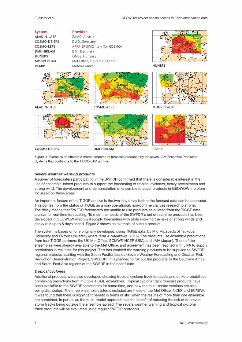
TIGGE-LAM archiveDuring GEOWOW, the pre-existing global TIGGE archive was extended by adding a limited-area model (LAM) counterpart, the TIGGE-LAM archive for Europe. The new database is updated regularly with datasets from seven European LAM Ensemble Prediction Systems (EPS): ALADIN-LAEF, COSMO-DE-EPS, COSMO-LEPS, HUNEPS, MOGREPS-UK, PEARP, and DMI-HIRLAM (Figure 1).
The forecasts in the archive are produced with grid spacings of 2 to 12 km and provide detailed information for the short range, up to a few days ahead. Such forecasts complement the larger-scale information provided by the global data in the established TIGGE archive. Only high-priority surface parameters are archived (mean sea level pressure, 10-metre wind components, wind gust, 2-metre temperature and dew point temperature, total precipitation, CAPE and CIN convective indices, orography and land–sea mask). The TIGGE-LAM archive, which is hosted by ECMWF, was officially launched in March 2014.
TIGGE-LAM datasets are freely accessible using standard ECMWF tools (data portal, WEB-API). The data are available for scientific research (with a 48-hour delay) after a simple electronic registration process in the same way as the global data. Users have already started experimenting with TIGGE-LAM data by comparing models (for example global vs regional) and improving the methodologies for the generation and application of regional ensemble forecasts.
Time-series archive prototypeIn order to improve the accessibility of the TIGGE and TIGGE-LAM databases, a prototype of a time-series archive has been developed in GEOWOW. The aim is to provide an efficient way of accessing long time series (over several years) of forecast data at specific geographical locations. Currently the retrieval of forecast time series for any point requires accessing the series of whole fields (global or limited area), which is very inefficient and makes data access very slow.
Although the production version of the time-series archive has not been achieved, the experience gathered in this area constitutes a good basis for further development after GEOWOW.
The infrastructure developed in GEOWOW will now also be used by other research projects, such as UERRA (Uncertainties in Ensembles of Regional Re-analysis; project funded under EU Framework Programme 7) and S2S (Sub-seasonal to Seasonal prediction project; WWRP-WCRP joint research project).
Forecast product developmentAn important area where improvements in data exploitability could be demonstrated was the development of new TIGGE-based products for high-impact weather. These products were developed in collaboration with users in developing and least developed countries and their value was demonstrated through the SWFDP framework.
SWFDPThe World Meteorological Organization’s Severe Weather Forecasting Demonstration Project (SWFDP) strengthens the capacity of National Meteorological and Hydrological Services in developing and least developed countries to deliver improved forecasts and warnings of severe weather to save lives, livelihoods and property.
The SWFDP is implemented as a number of Regional Projects, each using a ‘Cascading Forecasting Process’ (global to regional to national). The SWFDP was started in Southern Africa in 2006
and has now been rolled out in Eastern Africa, Southwest Pacific Islands and Southeast Asia. ECMWF and the Met Office both participate in the project as a global NWP centre, providing graphical products for the domains of each regional project as required for early warnings of high-impact and extreme weather events.
ECMWF contributes to three of the SWFDP Regional Projects. Participants in these projects can access the ECMWF forecast charts for their project using dedicated links (where a login is required).
B
E. Zsoter et al. GEOWOW project boosts access to Earth observation data
4 doi:10.21957/verls26y
Severe weather warning productsA survey of forecasters participating in the SWFDP confirmed that there is considerable interest in the use of ensemble-based products to support the forecasting of tropical cyclones, heavy precipitation and strong wind. The development and demonstration of ensemble forecast products in GEOWOW therefore focussed on these areas.
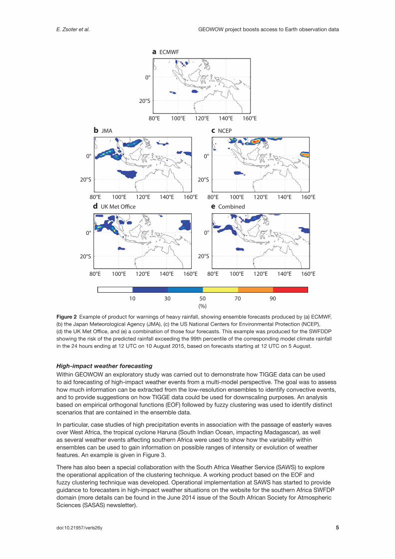
An important feature of the TIGGE archive is the two-day delay before the forecast data can be accessed. This comes from the status of TIGGE as a non-operational, non-commercial use research platform. The delay means that SWFDP forecasters are unable to use products calculated from the TIGGE data archive for real-time forecasting. To meet the needs of the SWFDP, a set of real-time products has been developed in GEOWOW which will supply forecasters with plots showing the risks of strong winds and heavy rain up to 5 days ahead. Figure 2 shows an example of such a product.
The system is based on one originally developed, using TIGGE data, by Mio Matsueda of Tsukuba University and Oxford University (Matsueda & Nakazawa, 2015). The products use ensemble predictions from four TIGGE partners: the UK Met Office, ECMWF, NCEP (USA) and JMA (Japan). Three of the ensembles were already available to the Met Office, and agreement has been reached with JMA to supply predictions in real time for this project. This has enabled the warning products to be supplied to SWFDP regional projects, starting with the South Pacific Islands (Severe Weather Forecasting and Disaster Risk Reduction Demonstration Project, SWFDDP). It is planned to roll out the products to the Southern Africa and South-East Asia regions of the SWFDP in the near future.
Tropical cyclonesAdditional products were also developed showing tropical cyclone track forecasts and strike probabilities combining predictions from multiple TIGGE ensembles. Tropical cyclone track forecast products have been available to the SWFDP forecasters for some time, and now the multi-centre versions are also being distributed. The three ensemble systems included are those of the Met Office, NCEP and ECMWF. It was found that there is significant benefit in terms of skill when the results of more than one ensemble are combined. In particular, the multi-model approach has the benefit of reducing the risk of observed storm tracks being outside the ensemble spread. The severe weather warning and tropical cyclone track products will be evaluated using regular SWFDP protocols.
System ProviderALADIN-LAEF ZAMG, AustriaCOSMO-DE-EPS DWD, GermanyCOSMO-LEPS ARPA-ER SIMC, Italy (for COSMO)DMI-HIRLAM DMI, DenmarkHUNEPS OMSZ, HungaryMOGREPS-UKPEARP Météo-France
MOGREPS-UK
PEARPDMI-HIRLAMCOSMO-DE-EPS
ALADIN-LAEF COSMO-LEPS
Met Office, United KingdomHUNEPS
Figure 1 Examples of different 2-metre temperature forecasts produced by the seven LAM Ensemble Prediction Systems that contribute to the TIGGE-LAM archive.
E. Zsoter et al. GEOWOW project boosts access to Earth observation data
doi:10.21957/verls26y 5
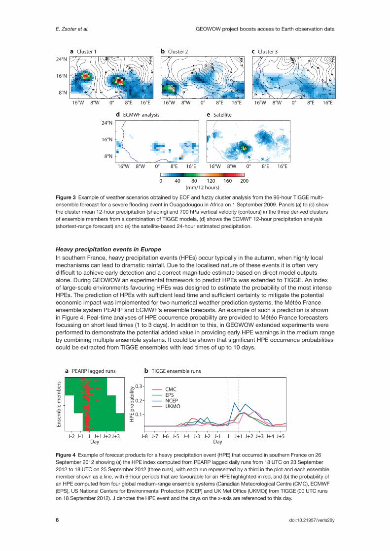
High-impact weather forecastingWithin GEOWOW an exploratory study was carried out to demonstrate how TIGGE data can be used to aid forecasting of high-impact weather events from a multi-model perspective. The goal was to assess how much information can be extracted from the low-resolution ensembles to identify convective events, and to provide suggestions on how TIGGE data could be used for downscaling purposes. An analysis based on empirical orthogonal functions (EOF) followed by fuzzy clustering was used to identify distinct scenarios that are contained in the ensemble data.
In particular, case studies of high precipitation events in association with the passage of easterly waves over West Africa, the tropical cyclone Haruna (South Indian Ocean, impacting Madagascar), as well as several weather events affecting southern Africa were used to show how the variability within ensembles can be used to gain information on possible ranges of intensity or evolution of weather features. An example is given in Figure 3.
There has also been a special collaboration with the South Africa Weather Service (SAWS) to explore the operational application of the clustering technique. A working product based on the EOF and fuzzy clustering technique was developed. Operational implementation at SAWS has started to provide guidance to forecasters in high-impact weather situations on the website for the southern Africa SWFDP domain (more details can be found in the June 2014 issue of the South African Society for Atmospheric Sciences (SASAS) newsletter).
Figure 2 Example of product for warnings of heavy rainfall, showing ensemble forecasts produced by (a) ECMWF, (b) the Japan Meteorological Agency (JMA), (c) the US National Centers for Environmental Protection (NCEP), (d) the UK Met Office, and (e) a combination of those four forecasts. This example was produced for the SWFDDP showing the risk of the predicted rainfall exceeding the 99th percentile of the corresponding model climate rainfall in the 24 hours ending at 12 UTC on 10 August 2015, based on forecasts starting at 12 UTC on 5 August.
(%)10 30 50 70 90
80°E
20°S
0°
100°E 120°E 140°E 160°E
a ECMWF
80°E 100°E 120°E 140°E 160°E
20°S
0°
e Combined
80°E
20°S
0°
100°E 120°E 140°E 160°E
b JMA
80°E
20°S
0°
100°E 120°E 140°E 160°E
c NCEP
80°E
20°S
0°
100°E 120°E 140°E 160°E
d UK Met O�ce
E. Zsoter et al. GEOWOW project boosts access to Earth observation data
6 doi:10.21957/verls26y
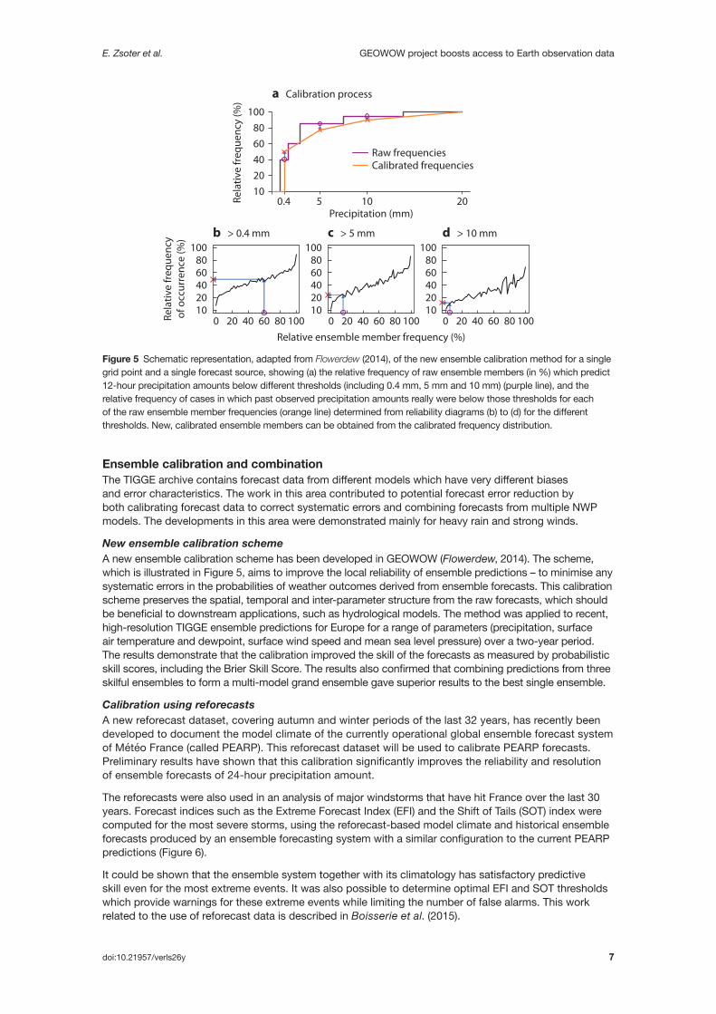
Heavy precipitation events in EuropeIn southern France, heavy precipitation events (HPEs) occur typically in the autumn, when highly local mechanisms can lead to dramatic rainfall. Due to the localised nature of these events it is often very difficult to achieve early detection and a correct magnitude estimate based on direct model outputs alone. During GEOWOW an experimental framework to predict HPEs was extended to TIGGE. An index of large-scale environments favouring HPEs was designed to estimate the probability of the most intense HPEs. The prediction of HPEs with sufficient lead time and sufficient certainty to mitigate the potential economic impact was implemented for two numerical weather prediction systems, the Météo France ensemble system PEARP and ECMWF’s ensemble forecasts. An example of such a prediction is shown in Figure 4. Real-time analyses of HPE occurrence probability are provided to Météo France forecasters focussing on short lead times (1 to 3 days). In addition to this, in GEOWOW extended experiments were performed to demonstrate the potential added value in providing early HPE warnings in the medium range by combining multiple ensemble systems. It could be shown that significant HPE occurrence probabilities could be extracted from TIGGE ensembles with lead times of up to 10 days.
Figure 3 Example of weather scenarios obtained by EOF and fuzzy cluster analysis from the 96-hour TIGGE multi-ensemble forecast for a severe flooding event in Ouagadougou in Africa on 1 September 2009. Panels (a) to (c) show the cluster mean 12-hour precipitation (shading) and 700 hPa vertical velocity (contours) in the three derived clusters of ensemble members from a combination of TIGGE models, (d) shows the ECMWF 12-hour precipitation analysis (shortest-range forecast) and (e) the satellite-based 24-hour estimated precipitation.
(mm/12 hours)0
0° 8°E8°W
8°N
16°N
24°N
16°W 16°E
0° 8°E8°W
8°N
16°N
24°N
16°W 16°E 0° 8°E8°W16°W 16°E
0° 8°E8°W16°W 16°E 0° 8°E8°W16°W 16°E
40 80 120 160 200
a Cluster 1 b Cluster 2
d ECMWF analysis e Satellite
c Cluster 3
Figure 4 Example of forecast products for a heavy precipitation event (HPE) that occurred in southern France on 26 September 2012 showing (a) the HPE index computed from PEARP lagged daily runs from 18 UTC on 23 September 2012 to 18 UTC on 25 September 2012 (three runs), with each run represented by a third in the plot and each ensemble member shown as a line, with 6-hour periods that are favourable for an HPE highlighted in red, and (b) the probability of an HPE computed from four global medium-range ensemble systems (Canadian Meteorological Centre (CMC), ECMWF (EPS), US National Centers for Environmental Protection (NCEP) and UK Met Office (UKMO)) from TIGGE (00 UTC runs on 18 September 2012). J denotes the HPE event and the days on the x-axis are referenced to this day.
J-2 J-1 J J+1Day
J+2 J+3 J-8
0.1
0.2
0.3
J-7
Ense
mbl
e m
embe
rs
HPE
pro
babi
lity
a PEARP lagged runs b TIGGE ensemble runs
J-6 J-5 J-4 J-3 J-2 J-1Day
CMCEPSNCEPUKMO
J J+1 J+2 J+3 J+4 J+5
E. Zsoter et al. GEOWOW project boosts access to Earth observation data
doi:10.21957/verls26y 7
Ensemble calibration and combinationThe TIGGE archive contains forecast data from different models which have very different biases and error characteristics. The work in this area contributed to potential forecast error reduction by both calibrating forecast data to correct systematic errors and combining forecasts from multiple NWP models. The developments in this area were demonstrated mainly for heavy rain and strong winds.
New ensemble calibration schemeA new ensemble calibration scheme has been developed in GEOWOW (Flowerdew, 2014). The scheme, which is illustrated in Figure 5, aims to improve the local reliability of ensemble predictions – to minimise any systematic errors in the probabilities of weather outcomes derived from ensemble forecasts. This calibration scheme preserves the spatial, temporal and inter-parameter structure from the raw forecasts, which should be beneficial to downstream applications, such as hydrological models. The method was applied to recent, high-resolution TIGGE ensemble predictions for Europe for a range of parameters (precipitation, surface air temperature and dewpoint, surface wind speed and mean sea level pressure) over a two-year period. The results demonstrate that the calibration improved the skill of the forecasts as measured by probabilistic skill scores, including the Brier Skill Score. The results also confirmed that combining predictions from three skilful ensembles to form a multi-model grand ensemble gave superior results to the best single ensemble.
Calibration using reforecastsA new reforecast dataset, covering autumn and winter periods of the last 32 years, has recently been developed to document the model climate of the currently operational global ensemble forecast system of Météo France (called PEARP). This reforecast dataset will be used to calibrate PEARP forecasts. Preliminary results have shown that this calibration significantly improves the reliability and resolution of ensemble forecasts of 24-hour precipitation amount.
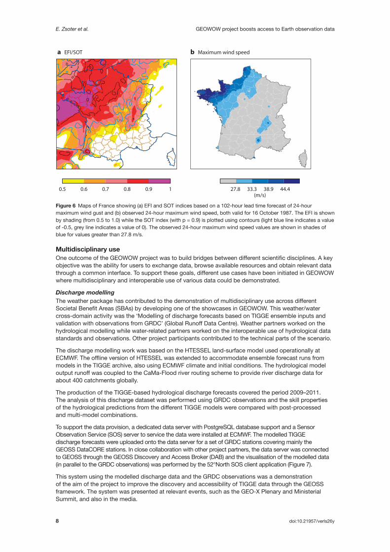
The reforecasts were also used in an analysis of major windstorms that have hit France over the last 30 years. Forecast indices such as the Extreme Forecast Index (EFI) and the Shift of Tails (SOT) index were computed for the most severe storms, using the reforecast-based model climate and historical ensemble forecasts produced by an ensemble forecasting system with a similar configuration to the current PEARP predictions (Figure 6).
It could be shown that the ensemble system together with its climatology has satisfactory predictive skill even for the most extreme events. It was also possible to determine optimal EFI and SOT thresholds which provide warnings for these extreme events while limiting the number of false alarms. This work related to the use of reforecast data is described in Boisserie et al. (2015).
Figure 5 Schematic representation, adapted from Flowerdew (2014), of the new ensemble calibration method for a single grid point and a single forecast source, showing (a) the relative frequency of raw ensemble members (in %) which predict 12-hour precipitation amounts below different thresholds (including 0.4 mm, 5 mm and 10 mm) (purple line), and the relative frequency of cases in which past observed precipitation amounts really were below those thresholds for each of the raw ensemble member frequencies (orange line) determined from reliability diagrams (b) to (d) for the different thresholds. New, calibrated ensemble members can be obtained from the calibrated frequency distribution.
1008060402010
0 20 40 60 80 100 0 20 40 60 80 100 0 20 40 60 80 100
1008060402010
1008060402010
100
Raw frequencies
8060402010
0.4 105 20Precipitation (mm)
Relative ensemble member frequency (%)
Rela
tive
freq
uenc
y (%
)
Rela
tive
freq
uenc
yof
occ
urre
nce
(%)
Calibrated frequencies
a Calibration process
b > 0.4 mm c > 5 mm d > 10 mm
E. Zsoter et al. GEOWOW project boosts access to Earth observation data
8 doi:10.21957/verls26y
Multidisciplinary useOne outcome of the GEOWOW project was to build bridges between different scientific disciplines. A key objective was the ability for users to exchange data, browse available resources and obtain relevant data through a common interface. To support these goals, different use cases have been initiated in GEOWOW where multidisciplinary and interoperable use of various data could be demonstrated.
Discharge modellingThe weather package has contributed to the demonstration of multidisciplinary use across different Societal Benefit Areas (SBAs) by developing one of the showcases in GEOWOW. This weather/water cross-domain activity was the ‘Modelling of discharge forecasts based on TIGGE ensemble inputs and validation with observations from GRDC’ (Global Runoff Data Centre). Weather partners worked on the hydrological modelling while water-related partners worked on the interoperable use of hydrological data standards and observations. Other project participants contributed to the technical parts of the scenario.
The discharge modelling work was based on the HTESSEL land-surface model used operationally at ECMWF. The offline version of HTESSEL was extended to accommodate ensemble forecast runs from models in the TIGGE archive, also using ECMWF climate and initial conditions. The hydrological model output runoff was coupled to the CaMa-Flood river routing scheme to provide river discharge data for about 400 catchments globally.
The production of the TIGGE-based hydrological discharge forecasts covered the period 2009–2011. The analysis of this discharge dataset was performed using GRDC observations and the skill properties of the hydrological predictions from the different TIGGE models were compared with post-processed and multi-model combinations.
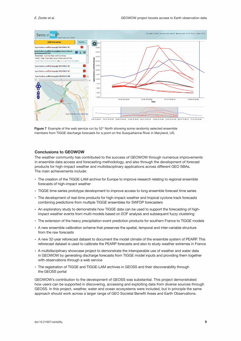
To support the data provision, a dedicated data server with PostgreSQL database support and a Sensor Observation Service (SOS) server to service the data were installed at ECMWF. The modelled TIGGE discharge forecasts were uploaded onto the data server for a set of GRDC stations covering mainly the GEOSS DataCORE stations. In close collaboration with other project partners, the data server was connected to GEOSS through the GEOSS Discovery and Access Broker (DAB) and the visualisation of the modelled data (in parallel to the GRDC observations) was performed by the 52°North SOS client application (Figure 7).
This system using the modelled discharge data and the GRDC observations was a demonstration of the aim of the project to improve the discovery and accessibility of TIGGE data through the GEOSS framework. The system was presented at relevant events, such as the GEO-X Plenary and Ministerial Summit, and also in the media.
Figure 6 Maps of France showing (a) EFI and SOT indices based on a 102-hour lead time forecast of 24-hour maximum wind gust and (b) observed 24-hour maximum wind speed, both valid for 16 October 1987. The EFI is shown by shading (from 0.5 to 1.0) while the SOT index (with p = 0.9) is plotted using contours (light blue line indicates a value of -0.5, grey line indicates a value of 0). The observed 24-hour maximum wind speed values are shown in shades of blue for values greater than 27.8 m/s.
a EFI/SOT b Maximum wind speed
0.5 0.7 0.8 0.90.6 1 27.8 38.9 44.433.3(m/s)
E. Zsoter et al. GEOWOW project boosts access to Earth observation data
doi:10.21957/verls26y 9
Conclusions to GEOWOWThe weather community has contributed to the success of GEOWOW through numerous improvements in ensemble data access and forecasting methodology, and also through the development of forecast products for high-impact weather and multidisciplinary applications across different GEO SBAs. The main achievements include:
• The creation of the TIGGE-LAM archive for Europe to improve research relating to regional ensemble forecasts of high-impact weather
• TIGGE time-series prototype development to improve access to long ensemble forecast time series
• The development of real-time products for high-impact weather and tropical cyclone track forecasts combining predictions from multiple TIGGE ensembles for SWFDP forecasters
• An exploratory study to demonstrate how TIGGE data can be used to support the forecasting of high-impact weather events from multi-models based on EOF analysis and subsequent fuzzy clustering
• The extension of the heavy precipitation event prediction products for southern France to TIGGE models
• A new ensemble calibration scheme that preserves the spatial, temporal and inter-variable structure from the raw forecasts
• A new 32-year reforecast dataset to document the model climate of the ensemble system of PEARP. This reforecast dataset is used to calibrate the PEARP forecasts and also to study weather extremes in France
• A multidisciplinary showcase project to demonstrate the interoperable use of weather and water data in GEOWOW by generating discharge forecasts from TIGGE model inputs and providing them together with observations through a web service
• The registration of TIGGE and TIGGE-LAM archives in GEOSS and their discoverability through the GEOSS portal
GEOWOW’s contribution to the development of GEOSS was substantial. This project demonstrated how users can be supported in discovering, accessing and exploiting data from diverse sources through GEOSS. In this project, weather, water and ocean ecosystems were included, but in principle the same approach should work across a larger range of GEO Societal Benefit Areas and Earth Observations.
Figure 7 Example of the web service run by 52° North showing some randomly selected ensemble members from TIGGE discharge forecasts for a point on the Susquehanna River in Maryland, US.
E. Zsoter et al. GEOWOW project boosts access to Earth observation data
10 doi:10.21957/verls26y
Useful LinksTIGGE-LAM data portal http://apps.ecmwf.int/datasets/data/tigge-lam
More information about the TIGGE/TIGGE-LAM project www.ecmwf.int/en/research/projects/tigge
GEOWOW www.geowow.eu
GEOSS portal www.geoportal.org
SWFDP www.wmo.int/pages/prog/www/swfdp/
S2S (Sub-seasonal to Seasonal prediction project) https://software.ecmwf.int/wiki/display/S2S
UERRA (Uncertainties in Ensembles of Regional ReAnalysis) https://software.ecmwf.int/wiki/display/UER
SASAS newsletter http://web.csag.uct.ac.za/sasas/index.php/newsletter
C
Further readingBoisserie, M., L. Descamps, & P. Arbogast, 2015: Calibrated forecasts of extreme windstorms using Extreme Forecast Index (EFI) and Shift Of Tails (SOT). Wea. Forecasting. doi:10.1175/WAF-D-15-0027.1, in press.
Flowerdew, J., 2014: Calibrating ensemble reliability whilst preserving spatial structure. Tellus A, 66, 22662, doi:10.3402/tellusa.v66.22662.
Matsueda, M. & T. Nakazawa, 2015: Early warning products for severe weather events derived from operational medium-range ensemble forecasts. Met. Apps., 22, 213–222, doi: 10.1002/met.1444.
© Copyright 2016
European Centre for Medium-Range Weather Forecasts, Shinfield Park, Reading, RG2 9AX, England
The content of this Newsletter article is available for use under a Creative Commons Attribution-Non-Commercial- No-Derivatives-4.0-Unported Licence. See the terms at https://creativecommons.org/licenses/by-nc-nd/4.0/.
The information within this publication is given in good faith and considered to be true, but ECMWF accepts no liability for error or omission or for loss or damage arising from its use.