Geometric Image Processing · processing of a wide variety of remote sensing image data – whether...
6
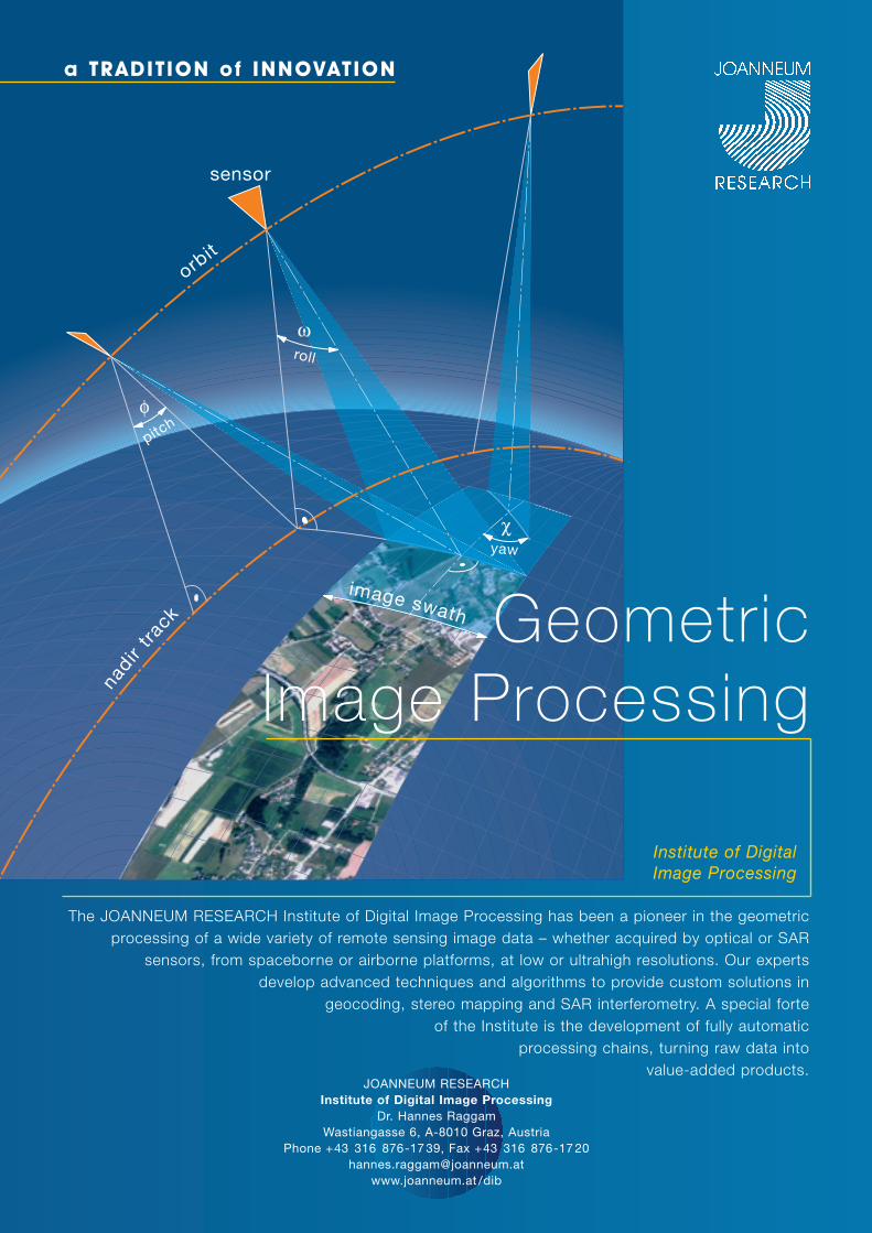
φ ω χ n ad ir t ra c k or bit sensor pitch roll yaw i m ag e s wa t h Geometric Image Processing a TRADITION of INNOVATION The JOANNEUM RESEARCH Institute of Digital Image Processing has been a pioneer in the geometric processing of a wide variety of remote sensing image data – whether acquired by optical or SAR sensors, from spaceborne or airborne platforms, at low or ultrahigh resolutions. Our experts develop advanced techniques and algorithms to provide custom solutions in geocoding, stereo mapping and SAR interferometry. A special forte of the Institute is the development of fully automatic processing chains, turning raw data into value-added products. JOANNEUM RESEARCH Institute of Digital Image Processing Dr. Hannes Raggam Wastiangasse 6, A-8010 Graz, Austria Phone +43 316 876-1739, Fax +43 316 876-1720 [email protected] www.joanneum.at/dib Institute of Digital Image Processing
Transcript of Geometric Image Processing · processing of a wide variety of remote sensing image data – whether...
φ
ω
χ
nadir
track
orbit
sensor
pitch
roll
yaw
image swath Geometric Image Processing
a TRADIT ION of INNOVATION
The JOANNEUM RESEARCH Institute of Digital Image Processing has been a pioneer in the geometric processing of a wide variety of remote sensing image data – whether acquired by optical or SAR
sensors, from spaceborne or airborne platforms, at low or ultrahigh resolutions. Our experts develop advanced techniques and algorithms to provide custom solutions in
geocoding, stereo mapping and SAR interferometry. A special forte of the Institute is the development of fully automatic
processing chains, turning raw data into value-added products.
JOANNEUM RESEARCHInstitute of Digital Image Processing
Dr. Hannes RaggamWastiangasse 6, A-8010 Graz, Austria
Phone +43 316 876-17 39, Fax +43 316 876-17 [email protected]
www.joanneum.at /dib
Institute of DigitalImage Processing
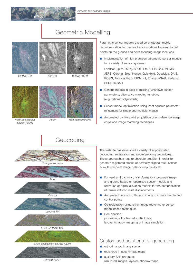
Parametric sensor models based on photogrammetric
techniques allow for precise transformations between target
points on the ground and corresponding image locations.
■ Implementation of high precision parametric sensor models
for a variety of sensor systems:
Landsat (up to TM 7), SPOT 1 to 5, IRS-C/D, MOMS,
JERS, Corona, Eros, Ikonos, Quickbird, Daedalus, DAIS,
ROSIS, Toposys RGB, ERS-1/2, Envisat ASAR, Radarsat,
SIR-C / X-SAR
■ Generic models in case of missing /unknown sensor
parameters; alternative mapping functions
(e. g. rational polynomials)
■ Sensor model optimisation using least squares parameter
refinement for single and multiple images
■ Automated control point acquisition using reference image
chips and image matching techniques
The Institute has developed a variety of sophisticatedgeocoding, registration and georeferencing procedures. These approaches require absolute precision in order togenerate registered stacks of perfectly aligned multi-sensor or multi-temporal image data or map products.
■ Forward and backward transformations between imageand ground based on optimised sensor models andutilisation of digital elevation models for the compensationof terrain induced relief displacements
■ Automated geocoding through image chip matching to findcontrol points
■ Co-registration using either image matching or sensormodel based techniques
■ SAR specials: processing of polarimetric SAR data, layover /shadow mapping or image simulation
Customised solutions for generating■ ortho-images, image stacks
■ registered images / image maps
■ auxiliary SAR products: simulated images, layover / shadow maps
Geometric Modelling
Geocoding
Topographic map
Landsat TM Corona Envisat ASAR
Multi-polarisation Envisat ASAR
Aster Multi-temporal ERS
Aster
Corona
Landsat TM
Multi-temporal ERS
Multi-polarisation Envisat ASAR
Envisat ASAR
Airborne line scanner image
Rock glacier surface
deformation mapgenerated from
ERS InSAR data
Special expertise exists in the development of generic
procedures for extracting 3D information from a wide range
of remote sensing stereo images acquired by optical and SAR
sensors. Recent developments focus on high-resolution stereo
data, which may often be acquired simultaneously in the same
overflight. Such image pairs provide the basis for generating
digital surface models of high quality.
■ Development and upgrade of a variety of automated image
matching techniques
■ Extraction of 3D information from any kind of stereoscopic
remote sensing image data
■ Automated tie-point acquisition through matching of points
of interest
■ Combination of image pairs acquired by different
instruments
Customised solutions for generating■ digital elevation / surface models
Image Matching and Stereo Mapping
SAR Interferometry
Stereo DEM from Ikonos
Ikonos stereo images Digital surface modelSuperimposed ortho images
Stereo DEM from JERS
The Institute has long-term expertise in SAR image data
processing including algorithm development and optimisation
for interferometric SAR (INSAR) data. Research in this field
covers standard and innovative approaches to extracting
information from INSAR data.
■ Standard INSAR processing, e. g. interferogram filtering,
atmospheric effects removal, coherence estimation, phase
unwrapping with sparse matrix algorithm
■ Differential INSAR processing, e. g. optimisation of interfer-
ogram simulation from DEM, generation of 3D velocity vec-
tors from surface displacement maps
■ INSAR gradient approach, e. g. generation of topograms,
fluxograms, velograms and slope maps
■ Permanent scatterers techniques
■ Large range of sensors supported:
ERS-SAR, JERS-SAR, SIR-C, RADARSAT, ENVISAT-ASAR;
others (e. g. airborne) as needed
Customised solutions for generating ■ interferometric standard products (interferograms, coher-
ence maps, unwrapped interferograms and DEMs)
■ simulated interferograms from DEMs,
surface displacement maps
■ topograms, fluxograms, velograms and slope maps
Anaglyph image
Perspective view from NE
Painted shaded relief of DEM generated fromERS InSARtandem data
Modelling of airborne line scanner image
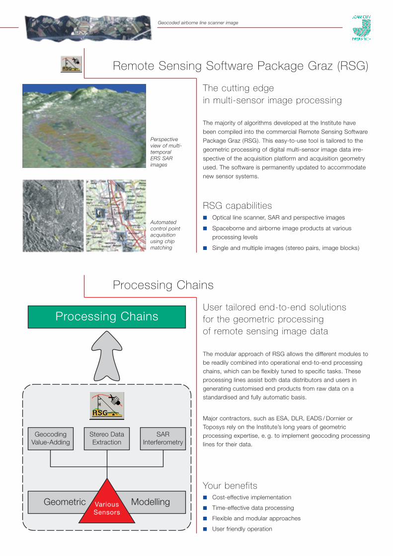
Remote Sensing Software Package Graz (RSG)
Processing Chains
The cutting edge in multi-sensor image processing
The majority of algorithms developed at the Institute have
been compiled into the commercial Remote Sensing Software
Package Graz (RSG). This easy-to-use tool is tailored to the
geometric processing of digital multi-sensor image data irre-
spective of the acquisition platform and acquisition geometry
used. The software is permanently updated to accommodate
new sensor systems.
RSG capabilities■ Optical line scanner, SAR and perspective images
■ Spaceborne and airborne image products at various
processing levels
■ Single and multiple images (stereo pairs, image blocks)
User tailored end-to-end solutions for the geometric processing of remote sensing image data
The modular approach of RSG allows the different modules tobe readily combined into operational end-to-end processingchains, which can be flexibly tuned to specific tasks. Theseprocessing lines assist both data distributors and users ingenerating customised end products from raw data on astandardised and fully automatic basis.
Major contractors, such as ESA, DLR, EADS / Dornier orToposys rely on the Institute’s long years of geometricprocessing expertise, e. g. to implement geocoding processinglines for their data.
Your benefits■ Cost-effective implementation
■ Time-effective data processing
■ Flexible and modular approaches
■ User friendly operation
Geometric ModellingVariousSensors
Stereo DataExtraction
GeocodingValue-Adding
Processing Chains
SARInterferometry
Automated control pointacquisition using chipmatching
Geocoded airborne line scanner image
Perspective view of multi-temporal ERS SARimages
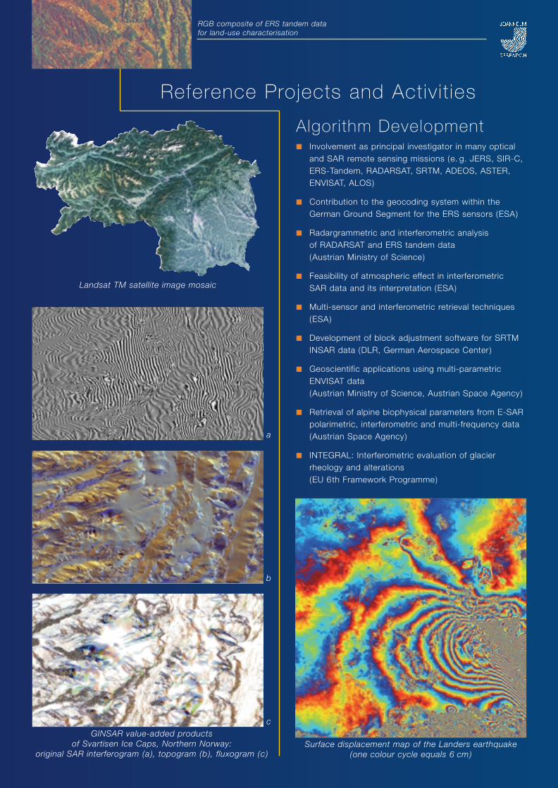
Algorithm Development■ Involvement as principal investigator in many optical
and SAR remote sensing missions (e. g. JERS, SIR-C,ERS-Tandem, RADARSAT, SRTM, ADEOS, ASTER,ENVISAT, ALOS)
■ Contribution to the geocoding system within theGerman Ground Segment for the ERS sensors (ESA)
■ Radargrammetric and interferometric analysis of RADARSAT and ERS tandem data (Austrian Ministry of Science)
■ Feasibility of atmospheric effect in interferometric SAR data and its interpretation (ESA)
■ Multi-sensor and interferometric retrieval techniques(ESA)
■ Development of block adjustment software for SRTMINSAR data (DLR, German Aerospace Center)
■ Geoscientific applications using multi-parametricENVISAT data (Austrian Ministry of Science, Austrian Space Agency)
■ Retrieval of alpine biophysical parameters from E-SARpolarimetric, interferometric and multi-frequency data(Austrian Space Agency)
■ INTEGRAL: Interferometric evaluation of glacierrheology and alterations (EU 6th Framework Programme)
Landsat TM satellite image mosaic
RGB composite of ERS tandem data for land-use characterisation
a
b
cGINSAR value-added products
of Svartisen Ice Caps, Northern Norway: original SAR interferogram (a), topogram (b), fluxogram (c)
Surface displacement map of the Landers earthquake (one colour cycle equals 6 cm)
Reference Projects and Activit ies
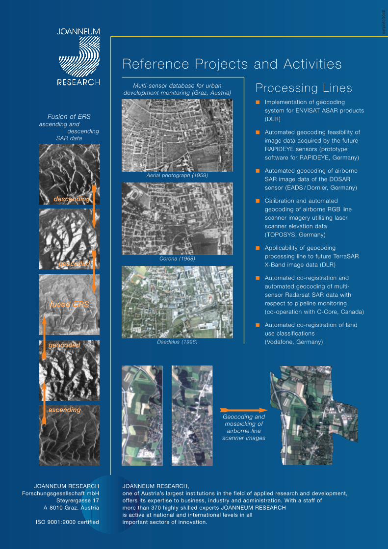
Processing Lines■ Implementation of geocoding
system for ENVISAT ASAR products(DLR)
■ Automated geocoding feasibility ofimage data acquired by the futureRAPIDEYE sensors (prototypesoftware for RAPIDEYE, Germany)
■ Automated geocoding of airborneSAR image data of the DOSARsensor (EADS / Dornier, Germany)
■ Calibration and automatedgeocoding of airborne RGB linescanner imagery utilising laserscanner elevation data (TOPOSYS, Germany)
■ Applicability of geocodingprocessing line to future TerraSARX-Band image data (DLR)
■ Automated co-registration andautomated geocoding of multi-sensor Radarsat SAR data withrespect to pipeline monitoring (co-operation with C-Core, Canada)
■ Automated co-registration of landuse classifications (Vodafone, Germany)
oef
pb
f03
040
Geocoding andmosaicking ofairborne line
scanner images
Aerial photograph (1959)
Fusion of ERSascending and
descending SAR data
ascending
geocoded
fused ERS
geocoded
descending
Reference Projects and Activit ies
Corona (1968)
Daedalus (1996)
JOANNEUM RESEARCHForschungsgesellschaft mbH
Steyrergasse 17A-8010 Graz, Austria
ISO 9001:2000 certified
JOANNEUM RESEARCH, one of Austria’s largest institutions in the field of applied research and development, offers its expertise to business, industry and administration. With a staff of more than 370 highly skilled experts JOANNEUM RESEARCH is active at national and international levels in all important sectors of innovation.
Multi-sensor database for urbandevelopment monitoring (Graz, Austria)
ascending
geocoded
fused ERS
geocoded
descending