Γεωπληροφορική και Εκπαίδευση Η...
18
Τμήμα Τμήμα Γεωπληροφορικής Γεωπληροφορικής & & Τοπογραφίας Τοπογραφίας Γεωπληροφορική και Εκπαίδευση - Η Ελληνική Πραγματικότητα - Διημερίδα για την Εκπαίδευση στη Γεωπληροφορική Χαροκόπειο Πανεπιστήμιο - HellasGIs
Transcript of Γεωπληροφορική και Εκπαίδευση Η...
ΤμήμαΤμήμα ΓεωπληροφορικήςΓεωπληροφορικής & & ΤοπογραφίαςΤοπογραφίας
Γεωπληροφορική και Εκπαίδευση- Η Ελληνική Πραγματικότητα -
Διημερίδα για την Εκπαίδευση στη Γεωπληροφορική
Χαροκόπειο Πανεπιστήμιο - HellasGIs
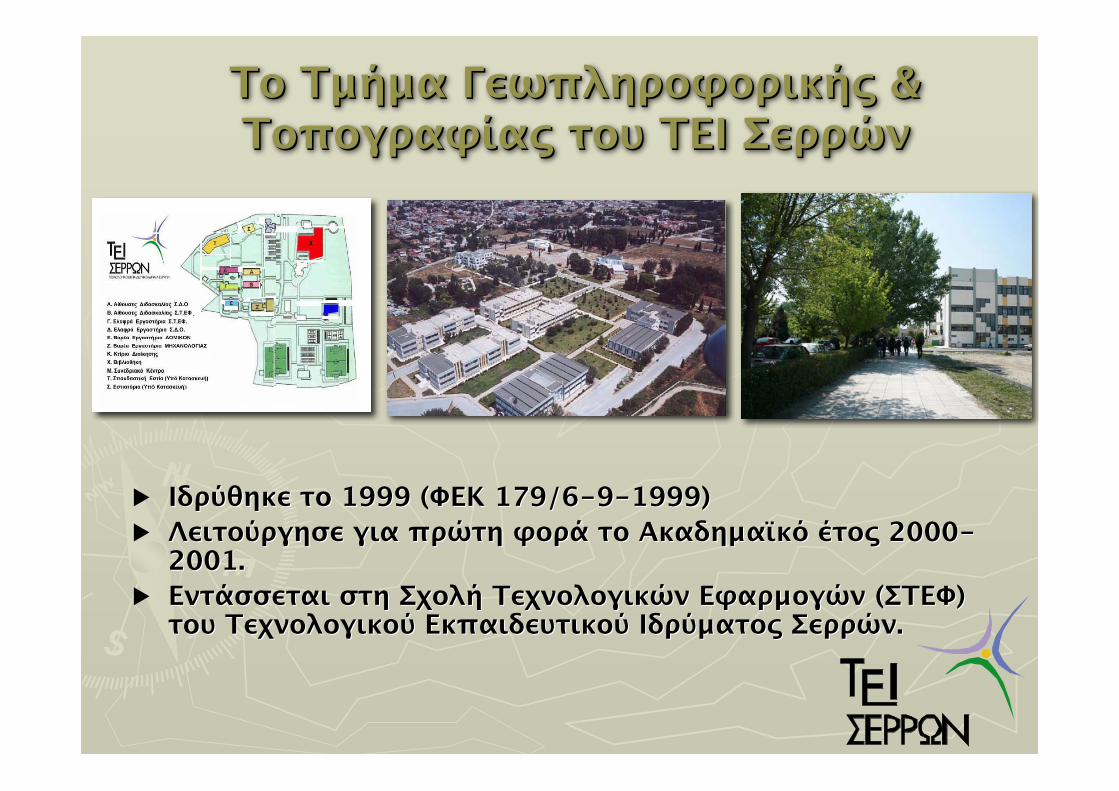
ΤοΤο ΤμήμαΤμήμα ΓεωπληροφορικήςΓεωπληροφορικής &&ΤοπογραφίαςΤοπογραφίας τουτου ΤΕΙΤΕΙ ΣερρώνΣερρών
▶ ΙδρύθηκεΙδρύθηκε τοτο 1999 ( 1999 (ΦΕΚΦΕΚ 179/6-9-1999) 179/6-9-1999)▶ ΛειτούργησεΛειτούργησε γιαγια πρώτηπρώτη φοράφορά τοτο ΑκαδημαϊκόΑκαδημαϊκό έτοςέτος 2000- 2000-
2001.2001.▶ ΕντάσσεταιΕντάσσεται στηστη ΣχολήΣχολή ΤεχνολογικώνΤεχνολογικών ΕφαρμογώνΕφαρμογών ( (ΣΤΕΦΣΤΕΦ))τουτου ΤεχνολογικούΤεχνολογικού ΕκπαιδευτικούΕκπαιδευτικού ΙδρύματοςΙδρύματος ΣερρώνΣερρών..
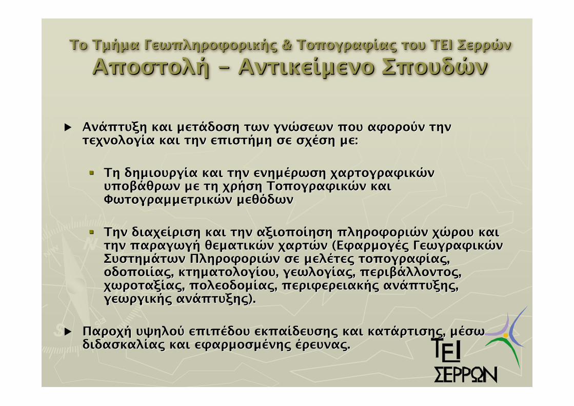
ΤοΤο ΤμήμαΤμήμα ΓεωπληροφορικήςΓεωπληροφορικής & & ΤοπογραφίαςΤοπογραφίας τουτου ΤΕΙΤΕΙ ΣερρώνΣερρών
ΑποστολήΑποστολή - - ΑντικείμενοΑντικείμενο ΣπουδώνΣπουδών
▶ AAνάπτυξηνάπτυξη καικαι μετάδοσημετάδοση τωντων γνώσεωνγνώσεων πουπου αφορούναφορούν τηντηντεχνολογίατεχνολογία καικαι τηντην επιστήμηεπιστήμη σεσε σχέσησχέση μεμε::
ΤηΤη δημιουργίαδημιουργία καικαι τηντην ενημέρωσηενημέρωση χαρτογραφικώνχαρτογραφικώνυποβάθρωνυποβάθρων μεμε τητη χρήσηχρήση ΤοπογραφικώνΤοπογραφικών καικαιΦωτογραμμετρικώνΦωτογραμμετρικών μεθόδωνμεθόδων
ΤηνΤην διαχείρισηδιαχείριση καικαι τηντην αξιοποίησηαξιοποίηση πληροφοριώνπληροφοριών χώρουχώρου καικαιτηντην παραγωγήπαραγωγή θεματικώνθεματικών χαρτώνχαρτών ( (ΕφαρμογέςΕφαρμογές ΓεωγραφικώνΓεωγραφικώνΣυστημάτωνΣυστημάτων ΠληροφοριώνΠληροφοριών σεσε μελέτεςμελέτες τοπογραφίαςτοπογραφίας,,οδοποιίαςοδοποιίας, , κτηματολογίουκτηματολογίου, , γεωλογίαςγεωλογίας, , περιβάλλοντοςπεριβάλλοντος,,χωροταξίαςχωροταξίας, , πολεοδομίαςπολεοδομίας, , περιφερειακήςπεριφερειακής ανάπτυξηςανάπτυξης,,γεωργικήςγεωργικής ανάπτυξηςανάπτυξης).).
▶ ΠαροχήΠαροχή υψηλούυψηλού επιπέδουεπιπέδου εκπαίδευσηςεκπαίδευσης καικαι κατάρτισηςκατάρτισης, , μέσωμέσωδιδασκαλίαςδιδασκαλίας καικαι εφαρμοσμένηςεφαρμοσμένης έρευναςέρευνας..
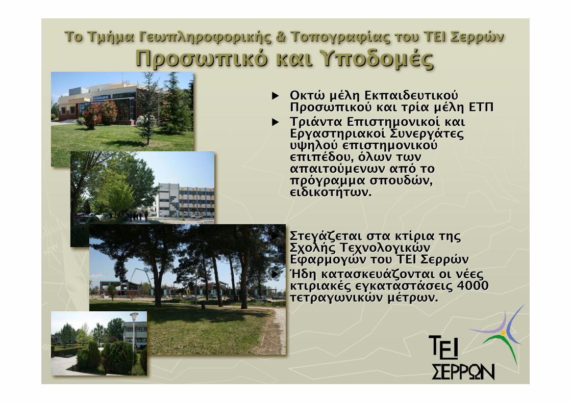
ΤοΤο ΤμήμαΤμήμα ΓεωπληροφορικήςΓεωπληροφορικής & & ΤοπογραφίαςΤοπογραφίας τουτου ΤΕΙΤΕΙ ΣερρώνΣερρών
ΠροσωπικόΠροσωπικό καικαι ΥποδομέςΥποδομές▶ ΟκτώΟκτώ μέλημέλη ΕκπαιδευτικούΕκπαιδευτικού
ΠροσωπικούΠροσωπικού καικαι τρίατρία μέλημέλη ΕΤΠΕΤΠ▶ ΤριάνταΤριάντα ΕπιστημονικοίΕπιστημονικοί καικαι
ΕργαστηριακοίΕργαστηριακοί ΣυνεργάτεςΣυνεργάτεςυψηλούυψηλού επιστημονικούεπιστημονικούεπιπέδουεπιπέδου,, όλωνόλων τωντωναπαιτούμενωναπαιτούμενων απόαπό τοτοπρόγραμμαπρόγραμμα σπουδώνσπουδών,,ειδικοτήτωνειδικοτήτων..
▶ ΣτεγάζεταιΣτεγάζεται σταστα κτίριακτίρια τηςτηςΣχολήςΣχολής ΤεχνολογικώνΤεχνολογικώνΕφαρμογώνΕφαρμογών τουτου ΤΕΙΤΕΙ ΣερρώνΣερρών
▶ ΉδηΉδη κατασκευάζονταικατασκευάζονται οιοι νέεςνέεςκτιριακέςκτιριακές εγκαταστάσειςεγκαταστάσεις 4000 4000τετραγωνικώντετραγωνικών μέτρωνμέτρων..
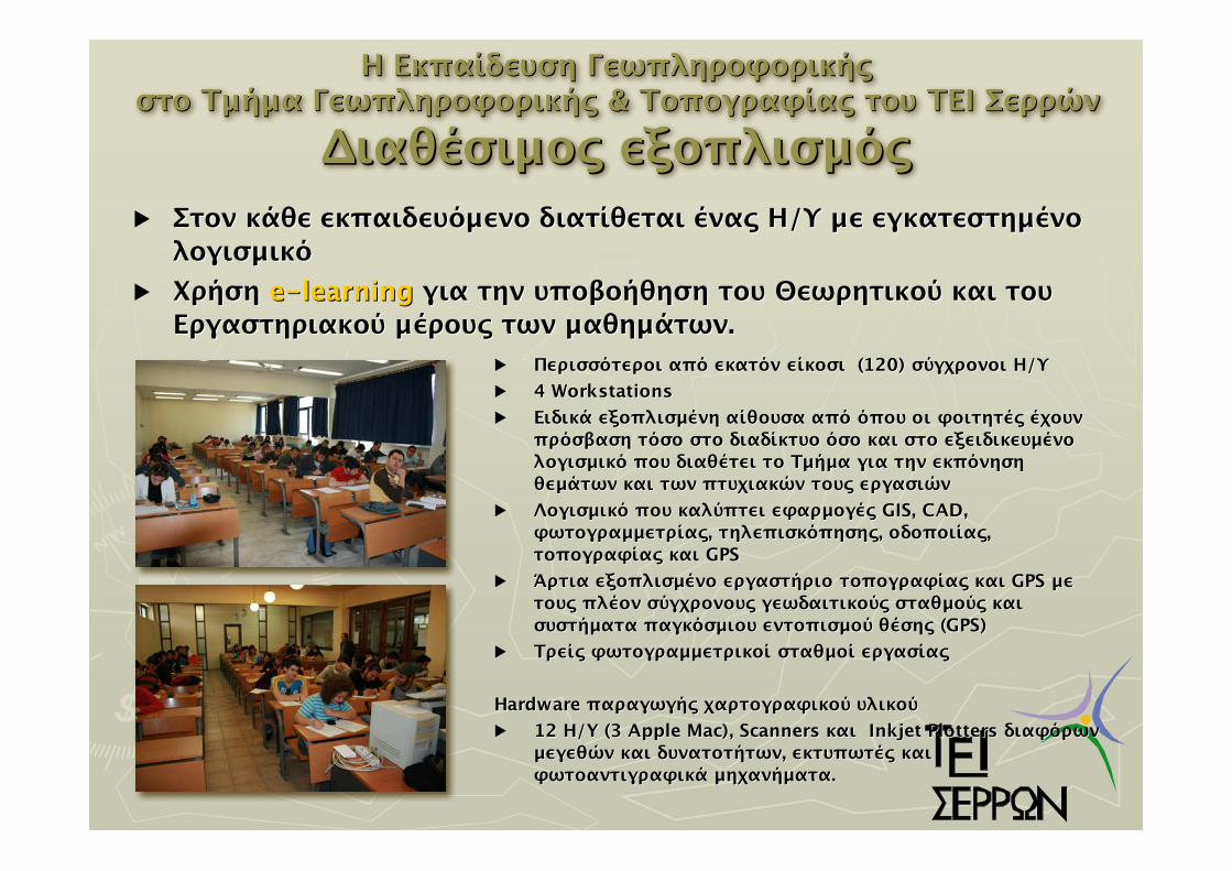
ΗΗ ΕκπαίδευσηΕκπαίδευση ΓεωπληροφορικήςΓεωπληροφορικήςστοστο ΤμήμαΤμήμα ΓεωπληροφορικήςΓεωπληροφορικής & & ΤοπογραφίαςΤοπογραφίας τουτου ΤΕΙΤΕΙ ΣερρώνΣερρών
ΔιαθέσιμοςΔιαθέσιμος εξοπλισμόςεξοπλισμός
▶ ΠερισσότεροιΠερισσότεροι απόαπό εκατόνεκατόν είκοσιείκοσι (120) (120) σύγχρονοισύγχρονοι ΗΗ//ΥΥ▶ 4 Workstations4 Workstations▶ ΕιδικάΕιδικά εξοπλισμένηεξοπλισμένη αίθουσααίθουσα απόαπό όπουόπου οιοι φοιτητέςφοιτητές έχουνέχουν
πρόσβασηπρόσβαση τόσοτόσο στοστο διαδίκτυοδιαδίκτυο όσοόσο καικαι στοστο εξειδικευμένοεξειδικευμένολογισμικόλογισμικό πουπου διαθέτειδιαθέτει τοτο TTμήμαμήμα γιαγια τηντην εκπόνησηεκπόνησηθεμάτωνθεμάτων καικαι τωντων πτυχιακώνπτυχιακών τουςτους εργασιώνεργασιών
▶ ΛογισμικόΛογισμικό πουπου καλύπτεικαλύπτει εφαρμογέςεφαρμογές GISGIS, , CADCAD,,φωτογραμμετρίαςφωτογραμμετρίας, , τηλεπισκόπησηςτηλεπισκόπησης, , οδοποιίαςοδοποιίας,,τοπογραφίαςτοπογραφίας καικαι GPSGPS
▶ ΆρτιαΆρτια εξοπλισμένοεξοπλισμένο εργαστήριοεργαστήριο τοπογραφίαςτοπογραφίας καικαι GPSGPS μεμετουςτους πλέονπλέον σύγχρονουςσύγχρονους γεωδαιτικούςγεωδαιτικούς σταθμούςσταθμούς καικαισυστήματασυστήματα παγκόσμιουπαγκόσμιου εντοπισμούεντοπισμού θέσηςθέσης ( (GPSGPS))
▶ ΤρείςΤρείς φωτογραμμετρικοίφωτογραμμετρικοί σταθμοίσταθμοί εργασίαςεργασίας
HardwareHardware παραγωγήςπαραγωγής χαρτογραφικούχαρτογραφικού υλικούυλικού▶ 12 H/Y 12 H/Y (3 (3 Apple Mac), Scanners Apple Mac), Scanners καικαι Inkjet PlottersInkjet Plotters διαφόρωνδιαφόρων
μεγεθώνμεγεθών καικαι δυνατοτήτωνδυνατοτήτων, , εκτυπωτέςεκτυπωτές καικαιφωτοαντιγραφικάφωτοαντιγραφικά μηχανήματαμηχανήματα..
▶ ΣτονΣτον κάθεκάθε εκπαιδευόμενοεκπαιδευόμενο διατίθεταιδιατίθεται έναςένας ΗΗ//ΥΥ μεμε εγκατεστημένοεγκατεστημένολογισμικόλογισμικό
▶ ΧρήσηΧρήση e-learninge-learning γιαγια τηντην υποβοήθησηυποβοήθηση τουτου ΘεωρητικούΘεωρητικού καικαι τουτουΕργαστηριακούΕργαστηριακού μέρουςμέρους τωντων μαθημάτωνμαθημάτων..
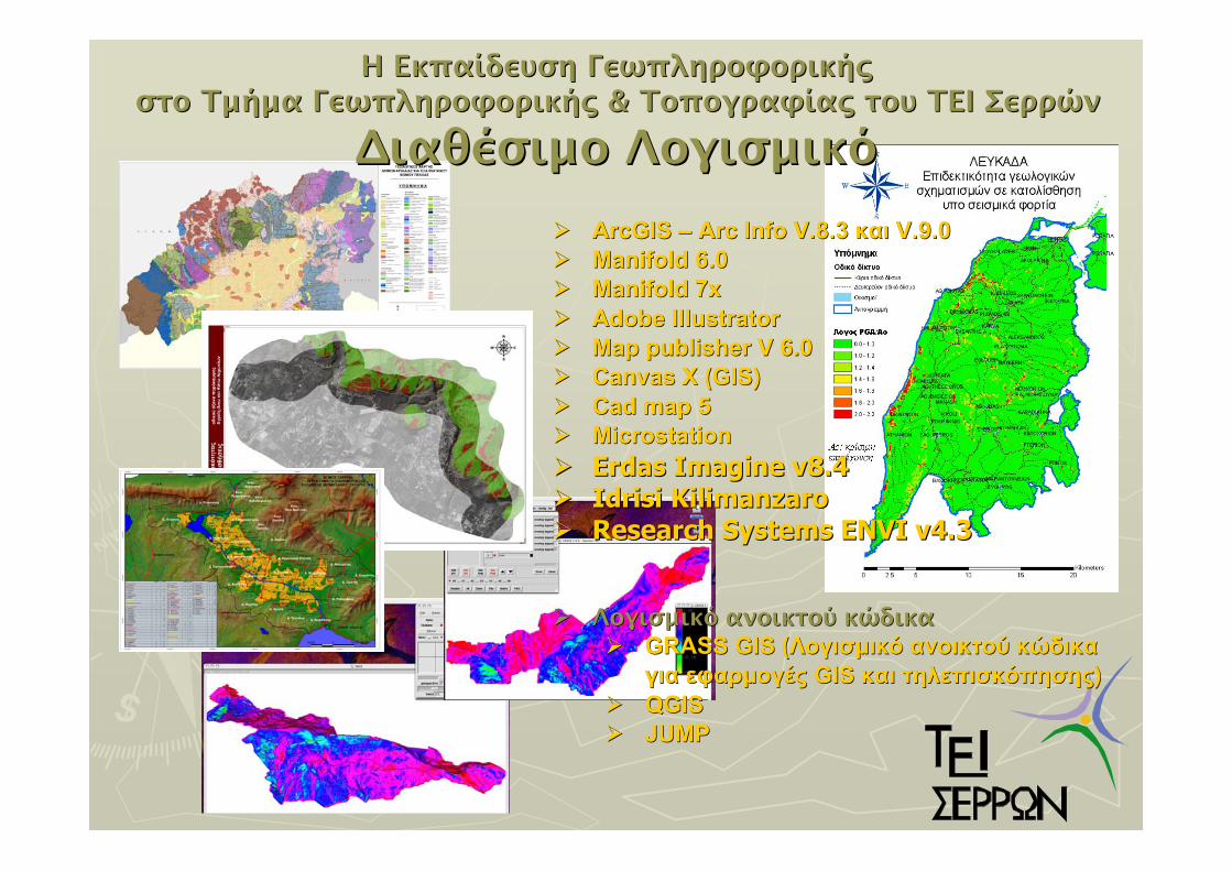
ArcGISArcGIS –– Arc Info VArc Info V.8.3 .8.3 καικαι VV.9.0.9.0 Manifold Manifold 6.06.0 Manifold 7xManifold 7x Adobe IllustratorAdobe Illustrator Map publisher VMap publisher V 6.0 6.0 Canvas XCanvas X ( (GISGIS)) Cad mapCad map 5 5 MicrostationMicrostation ErdasErdas Imagine Imagine v8.4v8.4 IdrisiIdrisi KilimanzaroKilimanzaro Research Systems ENVI v4.3Research Systems ENVI v4.3
ΛογισμικόΛογισμικό ανοικτούανοικτού κώδικακώδικα GRASS GISGRASS GIS ( (ΛογισµικόΛογισµικό ανοικτούανοικτού κώδικακώδικα
γιαγια εφαρµογέςεφαρµογές GISGIS καικαι τηλεπισκόπησηςτηλεπισκόπησης)) QGISQGIS JUMPJUMP
ΗΗ ΕκπαίδευσηΕκπαίδευση ΓεωπληροφορικήςΓεωπληροφορικήςστοστο ΤμήμαΤμήμα ΓεωπληροφορικήςΓεωπληροφορικής & & ΤοπογραφίαςΤοπογραφίας τουτου ΤΕΙΤΕΙ ΣερρώνΣερρών
ΔιαθέσιμοΔιαθέσιμο ΛογισμικόΛογισμικό
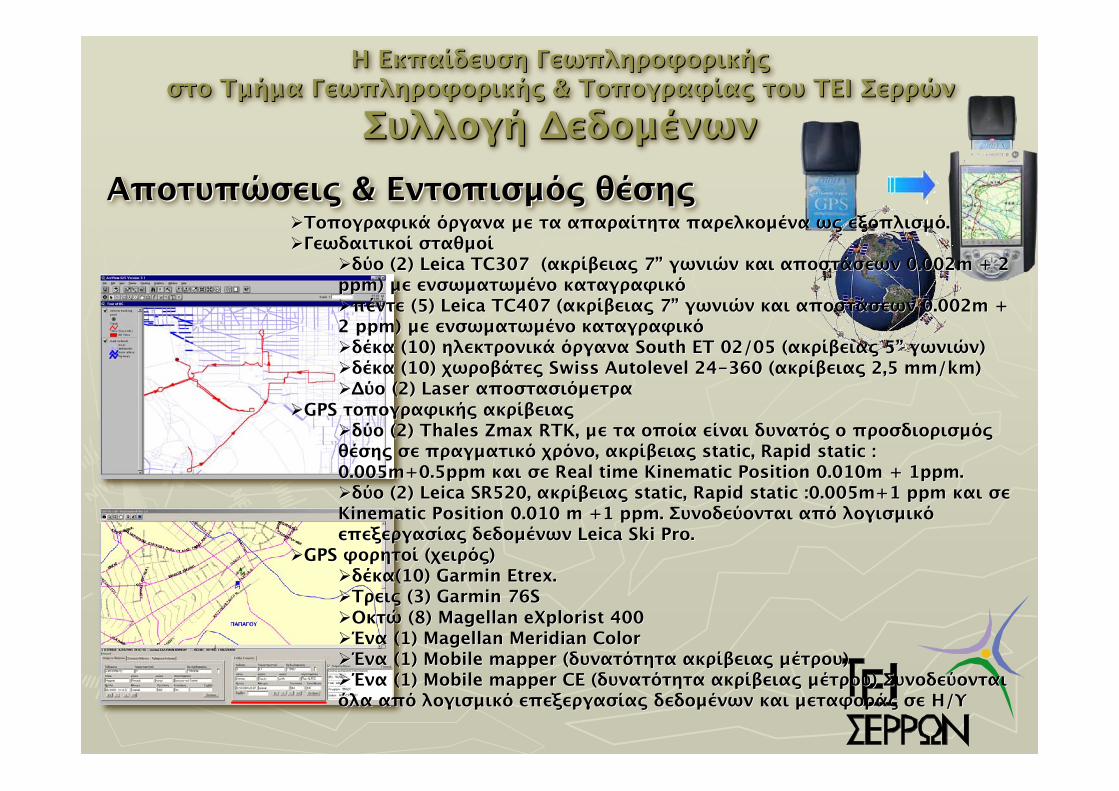
ΑποτυπώσειςΑποτυπώσεις & & ΕντοπισμόςΕντοπισμός θέσηςθέσηςΤοπογραφικάΤοπογραφικά όργαναόργανα μεμε τατα απαραίτητααπαραίτητα παρελκομέναπαρελκομένα ωςως εξοπλισμόεξοπλισμό..ΓεωδαιτικοίΓεωδαιτικοί σταθμοίσταθμοί
δύοδύο (2) (2) Leica Leica TCTC307 (307 (ακρίβειαςακρίβειας 7 7”” γωνιώνγωνιών καικαι αποστάσεωναποστάσεων 0.002 0.002mm + 2 + 2ppmppm) ) μεμε ενσωματωμένοενσωματωμένο καταγραφικόκαταγραφικόπέντεπέντε (5) (5) Leica Leica TCTC407 (407 (ακρίβειαςακρίβειας 7 7”” γωνιώνγωνιών καικαι αποστάσεωναποστάσεων 0.002 0.002mm + +2 2 ppmppm) ) μεμε ενσωματωμένοενσωματωμένο καταγραφικόκαταγραφικόδέκαδέκα (10) (10) ηλεκτρονικάηλεκτρονικά όργαναόργανα South ETSouth ET 02/05 ( 02/05 (ακρίβειαςακρίβειας 5 5”” γωνιώνγωνιών))δέκαδέκα (10) (10) χωροβάτεςχωροβάτες Swiss Swiss AutolevelAutolevel 24-360 ( 24-360 (ακρίβειαςακρίβειας 2,5 2,5 mmmm//kmkm))ΔύοΔύο (2) (2) LaserLaser αποστασιόμετρααποστασιόμετρα
GPSGPS τοπογραφικήςτοπογραφικής ακρίβειαςακρίβειαςδύοδύο (2) (2) Thales Zmax Thales Zmax RTKRTK, , μεμε τατα οποίαοποία είναιείναι δυνατόςδυνατός οο προσδιορισμόςπροσδιορισμόςθέσηςθέσης σεσε πραγματικόπραγματικό χρόνοχρόνο, , ακρίβειαςακρίβειας staticstatic, , Rapid staticRapid static : :0.0050.005mm+0.5+0.5ppmppm καικαι σεσε Real time Real time Kinematic Kinematic PositionPosition 0.010 0.010mm + 1 + 1ppmppm..δύοδύο (2) (2) Leica Leica SRSR520, 520, ακρίβειαςακρίβειας staticstatic, , Rapid staticRapid static :0.005 :0.005mm+1 +1 ppmppm καικαι σεσεKinematic Kinematic PositionPosition 0.010 0.010 mm +1 +1 ppmppm. . ΣυνοδεύονταιΣυνοδεύονται απόαπό λογισμικόλογισμικόεπεξεργασίαςεπεξεργασίας δεδομένωνδεδομένων Leica Leica Ski ProSki Pro..
GPSGPS φορητοίφορητοί ( (χειρόςχειρός))δέκαδέκα(10) (10) Garmin EtrexGarmin Etrex..ΤρειςΤρεις (3) (3) GarminGarmin 76 76SSΟκτώΟκτώ (8) (8) Magellan Magellan eXpleXplοοristrist 400 400ΈναΈνα (1) (1) Magellan Meridian ColorMagellan Meridian ColorΈναΈνα (1) (1) Mobile Mobile mappermapper ( (δυνατότηταδυνατότητα ακρίβειαςακρίβειας μέτρουμέτρου))ΈναΈνα (1) (1) Mobile Mobile mapper mapper CECE ( (δυνατότηταδυνατότητα ακρίβειαςακρίβειας μέτρουμέτρου) ) ΣυνοδεύονταιΣυνοδεύονταιόλαόλα απόαπό λογισμικόλογισμικό επεξεργασίαςεπεξεργασίας δεδομένωνδεδομένων καικαι μεταφοράςμεταφοράς σεσε ΗΗ//ΥΥ
ΗΗ ΕκπαίδευσηΕκπαίδευση ΓεωπληροφορικήςΓεωπληροφορικήςστοστο ΤμήμαΤμήμα ΓεωπληροφορικήςΓεωπληροφορικής & & ΤοπογραφίαςΤοπογραφίας τουτου ΤΕΙΤΕΙ ΣερρώνΣερρών
ΣυλλογήΣυλλογή ΔεδομένωνΔεδομένων
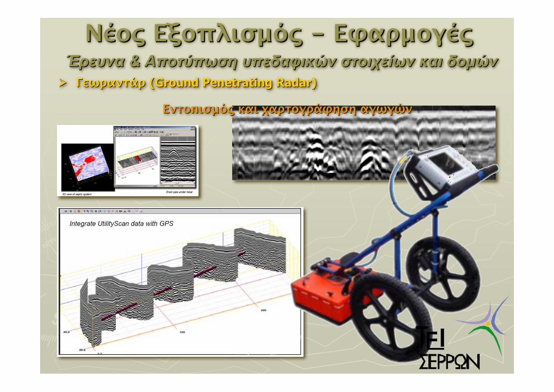
ΝέοςΝέος ΕξοπλισμόςΕξοπλισμός - - ΕφαρμογέςΕφαρμογέςΈρευναΈρευνα & & ΑποτύπωσηΑποτύπωση υπεδαφικώνυπεδαφικών στοιχείωνστοιχείων καικαι δοµώνδοµών
ΓεωραντάρΓεωραντάρ ((Ground Penetrating Radar)Ground Penetrating Radar)
ΕντοΕντοππισμόςισμός καικαι χαρτογράφησηχαρτογράφηση αγωγώναγωγών
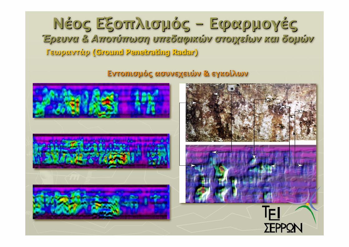
ΝέοςΝέος ΕξοπλισμόςΕξοπλισμός - - ΕφαρμογέςΕφαρμογέςΈρευναΈρευνα & & ΑποτύπωσηΑποτύπωση υπεδαφικώνυπεδαφικών στοιχείωνστοιχείων καικαι δοµώνδοµώνΓεωραντάρΓεωραντάρ ((Ground Penetrating Radar)Ground Penetrating Radar)
ΕντοΕντοππισμόςισμός ασυνεχειώνασυνεχειών & & εγκοίλωνεγκοίλων
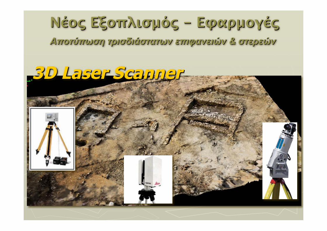
ΝέοςΝέος ΕξοπλισμόςΕξοπλισμός - - ΕφαρμογέςΕφαρμογέςΑποτύπωσηΑποτύπωση τρισδιάστατωντρισδιάστατων επιφανειώνεπιφανειών & & στερεώνστερεών
33D Laser ScannerD Laser Scanner
ΕκπαίδευσηΕκπαίδευση: : ΗΗ ΓεωπληροφορικήΓεωπληροφορικήστιςστις ΠροπτυχιακέςΠροπτυχιακές ΣπουδέςΣπουδές
((τρέχοντρέχον πρόγραμμαπρόγραμμα σπουδώνσπουδών))
▶ ΜαθήματαΜαθήματα ΠληροφορικήςΠληροφορικής ΕφαρμοσμένηΕφαρμοσμένη ΠληροφορικήΠληροφορική ΙΙ ΕφαρμοσμένηΕφαρμοσμένη ΠληροφορικήΠληροφορική ΙΙΙΙ ΒάσειςΒάσεις ΔεδομένωνΔεδομένων
▶ ΜαθήματαΜαθήματα ΓεωπληροφορικήςΓεωπληροφορικής ΕισαγωγήΕισαγωγή στηστη ΓεωπληροφορικήΓεωπληροφορική ΑλγοριθμικέςΑλγοριθμικές βάσειςβάσεις στηστη ΓεωπληροφορικήΓεωπληροφορική
▶ ΓεωγραφικάΓεωγραφικά ΣυστήματαΣυστήματα ΠληροφοριώνΠληροφοριών ΕισαγωγήΕισαγωγή σταστα ΓεωγραφικάΓεωγραφικά ΣυστήματαΣυστήματα ΠληροφοριώνΠληροφοριών (GIS I)(GIS I) ΕφαρμογέςΕφαρμογές τωντων ΓΓ..ΣΣ..ΠΠ. . (GIS II)(GIS II) ΕφαρμογέςΕφαρμογές τωντων ΓΓ..ΣΣ..ΠΠ. . στονστον ΧωροταξικόΧωροταξικό & & ΠολεοδομικόΠολεοδομικόσχεδιασμόσχεδιασμό ( (GIS III)GIS III)
ΕφαρμογέςΕφαρμογές ΤηλεπισκόπησηςΤηλεπισκόπησης στηστη δημιουργίαδημιουργία χαρτώνχαρτών ΧαρτογραφικέςΧαρτογραφικές εφαρμογέςεφαρμογές στηστη ΓεωλογίαΓεωλογία
ΔυνατότητεςΔυνατότητες τωντωνπτυχιούχωνπτυχιούχων
ΑπασχόλησηΑπασχόληση σεσε::
▶ ΜελέτεςΜελέτες τοπογραφίαςτοπογραφίας..▶ ΜελέτεςΜελέτες οδοποιίαςοδοποιίας..▶ ΜελέτεςΜελέτες δημιουργίαςδημιουργίας καικαι ανάπτυξηςανάπτυξης χαρτογραφικώνχαρτογραφικών υποβάθρωνυποβάθρων..▶ ΜελέτεςΜελέτες θεματικήςθεματικής χαρτογραφίαςχαρτογραφίας..▶ ΧωροταξικέςΧωροταξικές καικαι ρυθμιστικέςρυθμιστικές μελέτεςμελέτες..▶ ΠολεοδομικέςΠολεοδομικές καικαι ΡυμοτομικέςΡυμοτομικές μελέτεςμελέτες..▶ ΜελέτεςΜελέτες περιφερειακήςπεριφερειακής ανάπτυξηςανάπτυξης καικαι ανάπτυξηςανάπτυξης τουτου αγροτικούαγροτικού
χώρουχώρου ( (άρδευσηάρδευση, , διανομήδιανομή, , αναδασμόςαναδασμός).).▶ εκπαιδευτικάεκπαιδευτικά καικαι συμβουλευτικάσυμβουλευτικά καθήκοντακαθήκοντα σεσε θέματαθέματα
χαρτογραφικήςχαρτογραφικής υποδομήςυποδομής καικαι εφαρμογώνεφαρμογών γεωπληροφορικήςγεωπληροφορικήςστηνστην πρωτοβάθμιαπρωτοβάθμια καικαι δευτεροβάθμιαδευτεροβάθμια εκπαίδευσηεκπαίδευση τόσοτόσο στοστοδημόσιοδημόσιο, , όσοόσο καικαι στονστον ιδιωτικόιδιωτικό τομέατομέα..
ΦορείςΦορείς απασχόλησηςαπασχόλησηςΟιΟι ΠτυχιούχοιΠτυχιούχοι τουτου ΤμήματοςΤμήματος μπορούνμπορούν νανα απασχοληθούναπασχοληθούν στονστονευρύτεροευρύτερο δημόσιοδημόσιο τομέατομέα καικαι στονστον ιδιωτικόιδιωτικό τομέατομέα::
▶ ΤοπικήΤοπική ΑυτοδιοίκησηΑυτοδιοίκηση ( (ΝομαρχίεςΝομαρχίες, , ΔήμοιΔήμοι, , ΚοινότητεςΚοινότητες), ), στασταΤμήματαΤμήματα ΈργωνΈργων, , ΜελετώνΜελετών, , ΚτηματολογίουΚτηματολογίου, , ΠολεοδομίαςΠολεοδομίας,,ΥπηρεσίεςΥπηρεσίες ΎδρευσηςΎδρευσης καικαι ΑποχέτευσηςΑποχέτευσης, , ΑναπτυξιακέςΑναπτυξιακέςεπιχειρήσειςεπιχειρήσεις..
▶ ΟργανισμοίΟργανισμοί ΚοινήςΚοινής ΩφέλειαςΩφέλειας όπωςόπως είναιείναι ηη ΔΔ..ΕΕ..ΗΗ. . καικαι οο ΟΟ..ΤΤ..ΕΕ..σταστα τμήματατμήματα μελετώνμελετών καικαι διαχείρισηςδιαχείρισης τωντων δικτύωνδικτύων μεταφοράςμεταφοράςκαικαι διανομήςδιανομής
▶ ΦορείςΦορείς τουτου ΔημοσίουΔημοσίου όπωςόπως ΥπουργείαΥπουργεία, , ΠεριφέρειεςΠεριφέρειες καικαιεξειδικευμένουςεξειδικευμένους οργανισμούςοργανισμούς ήή επιχειρήσειςεπιχειρήσεις τουτου δημοσίουδημοσίου..
▶ ΣτηνΣτην ΜέσηΜέση ΕκπαίδευσηΕκπαίδευση σταστα ΤΤ..ΕΕ..ΛΛ. . καικαι ΤΤ..ΕΕ..ΣΣ..▶ ΩςΩς ιδιώτεςιδιώτες ΜηχανικοίΜηχανικοί μεμε τηντην σύνταξησύνταξη τοπογραφικώντοπογραφικών
διαγραμμάτωνδιαγραμμάτων καικαι μελετώνμελετών ιδιωτικώνιδιωτικών έργωνέργων..▶ ΣεΣε συνεργασίασυνεργασία μεμε μελετητικάμελετητικά ΓραφείαΓραφεία στηνστην σύνταξησύνταξη μελετώνμελετών τουτου
ΔημοσίουΔημοσίου, , στουςστους ΤομείςΤομείς τηςτης ΤοπογραφίαςΤοπογραφίας, , ΠολεοδομίαςΠολεοδομίας,,ΧωροταξίαςΧωροταξίας καικαι ΣυγκοινωνιακώνΣυγκοινωνιακών έργωνέργων καικαι γενικάγενικά σεσε όσεςόσεςμελέτεςμελέτες απαιτούναπαιτούν τητη χρήσηχρήση ΣυστημάτωνΣυστημάτων ΓεωγραφικώνΓεωγραφικώνΠληροφοριώνΠληροφοριών..
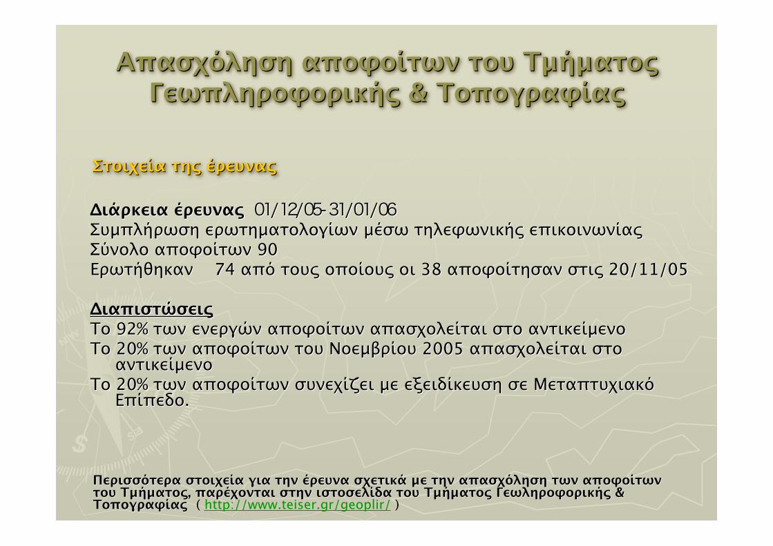
ΑπασχόλησηΑπασχόληση αποφοίτωναποφοίτων τουτου ΤμήματοςΤμήματοςΓεωπληροφορικήςΓεωπληροφορικής & & ΤοπογραφίαςΤοπογραφίας
ΣτοιχείαΣτοιχεία τηςτης έρευναςέρευνας
ΔιΔιάρκειαάρκεια έρευναςέρευνας 01/12/05-31/01/06 01/12/05-31/01/06ΣυμπλΣυμπλήρωσηήρωση ερωτηματολογίωνερωτηματολογίων μέσωμέσω τηλεφωνικήςτηλεφωνικής επικοινωνίαςεπικοινωνίαςΣύνολοΣύνολο αποφοίτωναποφοίτων 90 90ΕρωτήθηκανΕρωτήθηκαν 74 74 απόαπό τουςτους οποίουςοποίους οιοι 38 38 αποφοίτησαναποφοίτησαν στιςστις 20/11/05 20/11/05
ΔιαπιστΔιαπιστώσειςώσειςΤοΤο 92% 92% τωντων ενεργώνενεργών αποφοίτωναποφοίτων απασχολείταιαπασχολείται στοστο αντικείμενοαντικείμενοΤοΤο 20% 20% τωντων αποφοίτωναποφοίτων τουτου ΝοεμβρίουΝοεμβρίου 2005 2005 απασχολείταιαπασχολείται στοστο
αντικείμενοαντικείμενοΤοΤο 20% 20% τωντων αποφοίτωναποφοίτων συνεχίζεισυνεχίζει μεμε εξειδίκευσηεξειδίκευση σεσε ΜεταπτυχιακόΜεταπτυχιακό
ΕπίπεδοΕπίπεδο..
ΠερισσΠερισσότεραότερα στοιχείαστοιχεία γιαγια τηντην έρευναέρευνα σχετικάσχετικά μεμε τηντην απασχόλησηαπασχόληση τωντων αποφοίτωναποφοίτωντουτου ΤμήματοςΤμήματος, , παρέχονταιπαρέχονται στηνστην ιστοσελίδαιστοσελίδα τουτου ΤμήματοςΤμήματος ΓεωληροφορικήςΓεωληροφορικής & &ΤοπογραφίαςΤοπογραφίας ( http://www.teiser.gr/geoplir/ )
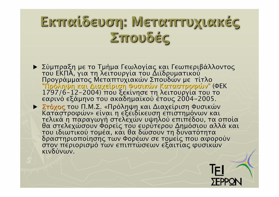
ΕκπαίδευσηΕκπαίδευση: : ΜεταπτυχιακέςΜεταπτυχιακέςΣπουδέςΣπουδές
▶ ΣύμπραξηΣύμπραξη μεμε τοτο ΤμήμαΤμήμα ΓεωλογίαςΓεωλογίας καικαι ΓεωπεριβάλλοντοςΓεωπεριβάλλοντοςτουτου ΕΚΠΑΕΚΠΑ, , γιαγια τητη λειτουργίαλειτουργία τουτου ΔιϊδρυματικούΔιϊδρυματικούΠρογράμματοςΠρογράμματος ΜεταπτυχιακώνΜεταπτυχιακών ΣπουδώνΣπουδών μεμε τίτλοτίτλο""ΠρόληψηΠρόληψη καικαι ΔιαχείρισηΔιαχείριση ΦυσικώνΦυσικών ΚαταστροφώνΚαταστροφών"" ( (ΦΕΚΦΕΚ1797/6-12-2004) 1797/6-12-2004) πουπου ξεκίνησεξεκίνησε τητη λειτουργίαλειτουργία τουτου τοτοεαρινόεαρινό εξάμηνοεξάμηνο τουτου ακαδημαϊκούακαδημαϊκού έτουςέτους 2004-2005. 2004-2005.
▶ ΣτόχοςΣτόχος τουτου ΠΠ..ΜΜ..ΣΣ.. « «ΠρόληψηΠρόληψη καικαι ΔιαχείρισηΔιαχείριση ΦυσικώνΦυσικώνΚαταστροφών»Καταστροφών» είναιείναι ηη εξειδίκευσηεξειδίκευση επιστημόνωνεπιστημόνων καικαιτελικάτελικά ηη παραγωγήπαραγωγή στελεχώνστελεχών υψηλούυψηλού επιπέδουεπιπέδου, , τατα οποίαοποίαθαθα στελεχώσουνστελεχώσουν ΦορείςΦορείς τουτου ευρύτερουευρύτερου ΔημόσιουΔημόσιου αλλάαλλά καικαιτουτου ιδιωτικούιδιωτικού τομέατομέα, , καικαι θαθα δώσουνδώσουν τητη δυνατότηταδυνατότηταδραστηριοποίησηςδραστηριοποίησης τωντων ΦορέωνΦορέων σεσε τομείςτομείς πουπου αφορούναφορούνστονστον περιορισμόπεριορισμό τωντων επιπτώσεωνεπιπτώσεων εξαιτίαςεξαιτίας φυσικώνφυσικώνκινδύνωνκινδύνων..
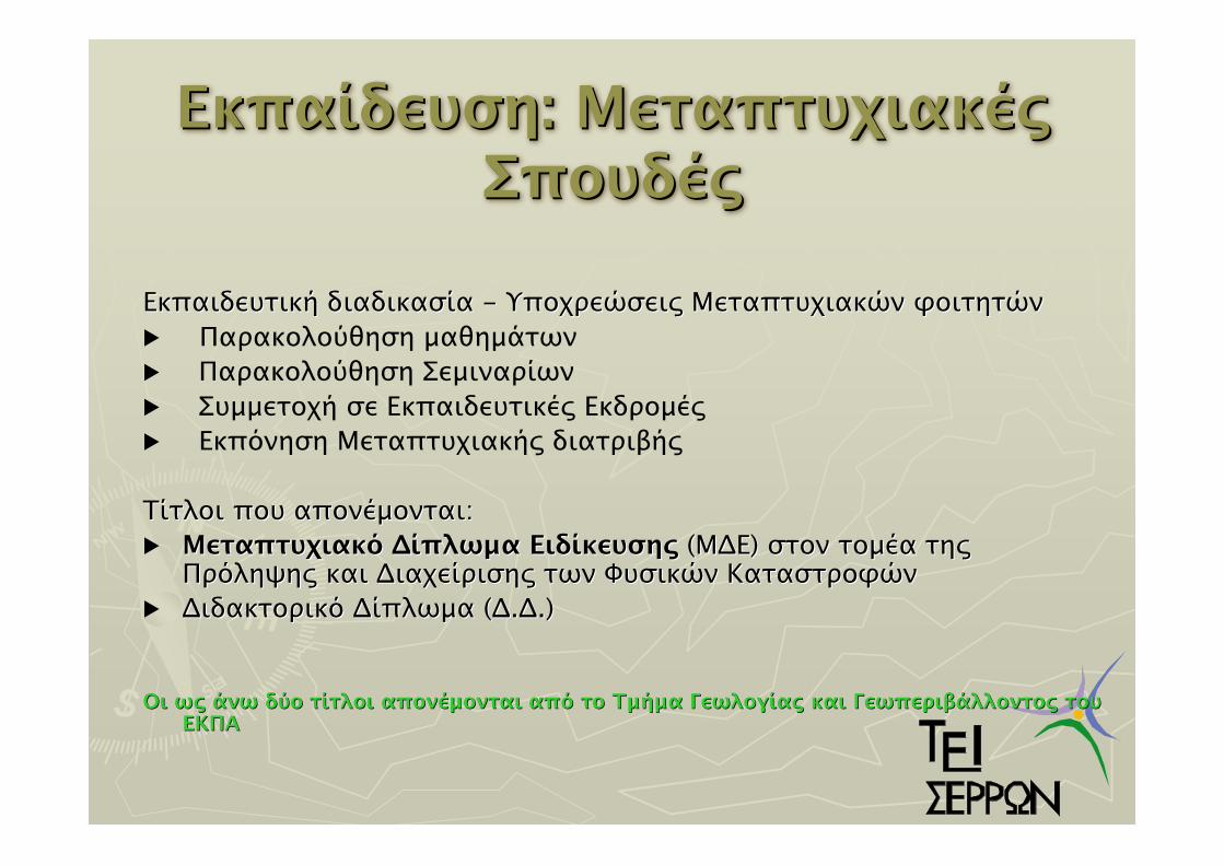
ΕκπαίδευσηΕκπαίδευση: : ΜεταπτυχιακέςΜεταπτυχιακέςΣπουδέςΣπουδές
ΕκπαιδευτικήΕκπαιδευτική διαδικασίαδιαδικασία - - ΥποχρεώσειςΥποχρεώσεις ΜεταπτυχιακώνΜεταπτυχιακών φοιτητώνφοιτητών▶ Παρακολούθηση μαθημάτων▶ Παρακολούθηση Σεμιναρίων▶ Συμμετοχή σε Εκπαιδευτικές Εκδρομές▶ Εκπόνηση Μεταπτυχιακής διατριβής
ΤΤίτλοιίτλοι πουπου απονέμονταιαπονέμονται::▶ ΜεταπτυχιακόΜεταπτυχιακό ΔίπλωμαΔίπλωμα ΕιδίκευσηςΕιδίκευσης ( (ΜΔΕΜΔΕ) ) στονστον τομέατομέα τηςτης
ΠρόληψηςΠρόληψης καικαι ΔιαχείρισηςΔιαχείρισης τωντων ΦυσικώνΦυσικών ΚαταστροφώνΚαταστροφών▶ ΔιδακτορικόΔιδακτορικό ΔίπλωμαΔίπλωμα ( (ΔΔ..ΔΔ.).)
ΟιΟι ωςως άνωάνω δύοδύο τίτλοιτίτλοι απονέμονταιαπονέμονται απόαπό τοτο ΤμήμαΤμήμα ΓεωλογίαςΓεωλογίας καικαι ΓεωπεριβάλλοντοςΓεωπεριβάλλοντος τουτουΕΚΠΑΕΚΠΑ
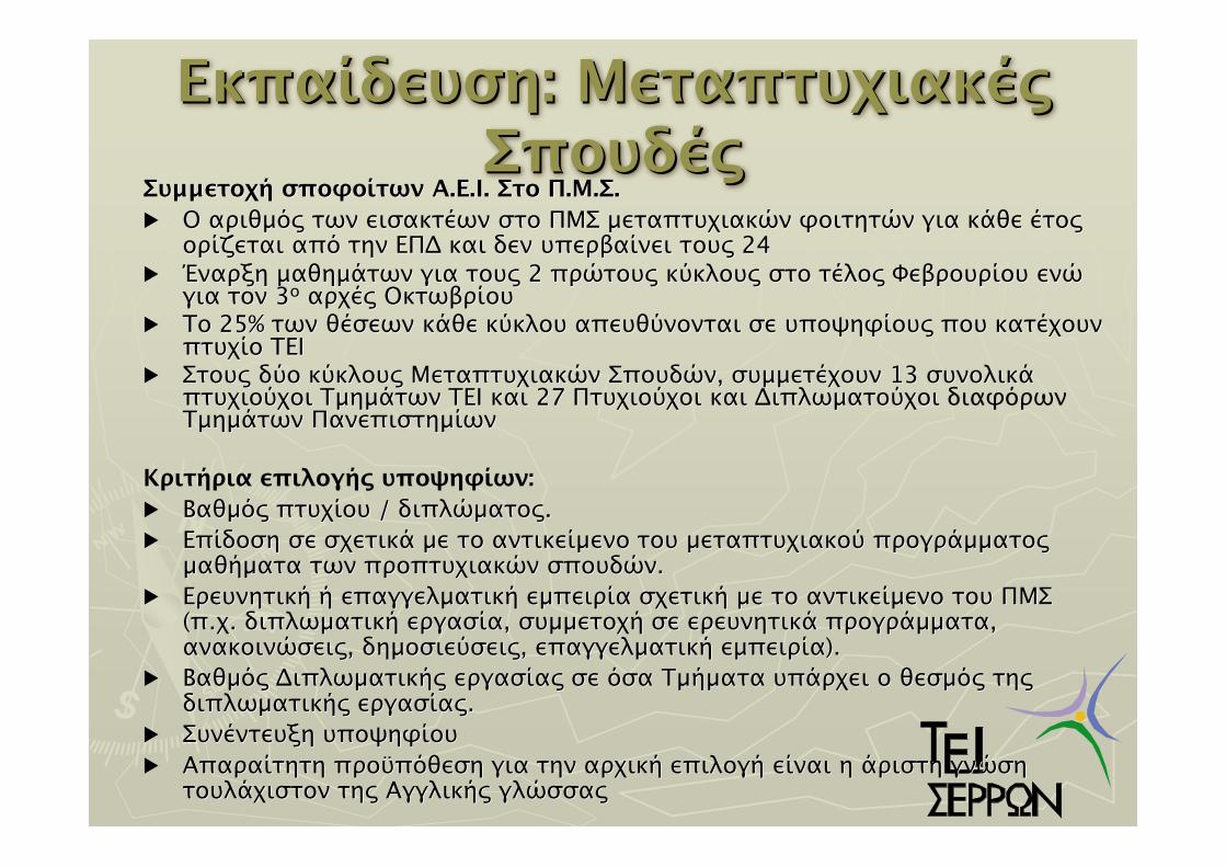
ΕκπαίδευσηΕκπαίδευση: : ΜεταπτυχιακέςΜεταπτυχιακέςΣπουδέςΣπουδές
ΣυμμετοχΣυμμετοχήή σποφοίτωνσποφοίτων ΑΑ..ΕΕ..ΙΙ. . ΣτοΣτο ΠΠ..ΜΜ..ΣΣ..▶ ΟΟ αριθμόςαριθμός τωντων εισακτέωνεισακτέων στοστο ΠΜΣΠΜΣ μεταπτυχιακώνμεταπτυχιακών φοιτητώνφοιτητών γιαγια κάθεκάθε έτοςέτος
ορίζεταιορίζεται απόαπό τηντην ΕΠΔΕΠΔ καικαι δενδεν υπερβαίνειυπερβαίνει τουςτους 2424▶ ΈναρξηΈναρξη μαθημάτωνμαθημάτων γιαγια τουςτους 2 2 πρώτουςπρώτους κύκλουςκύκλους στοστο τέλοςτέλος ΦεβρουρίουΦεβρουρίου ενώενώ
γιαγια τοντον 3 3οο αρχέςαρχές ΟκτωβρίουΟκτωβρίου▶ ΤοΤο 25% 25% τωντων θέσεωνθέσεων κάθεκάθε κύκλουκύκλου απευθύνονταιαπευθύνονται σεσε υποψηφίουςυποψηφίους πουπου κατέχουνκατέχουν
πτυχίοπτυχίο ΤΕΙΤΕΙ▶ ΣτουςΣτους δύοδύο κύκλουςκύκλους ΜεταπτυχιακώνΜεταπτυχιακών ΣπουδώνΣπουδών, , συμμετέχουνσυμμετέχουν 13 13 συνολικάσυνολικά
πτυχιούχοιπτυχιούχοι ΤμημάτωνΤμημάτων ΤΕΙΤΕΙ καικαι 27 27 ΠτυχιούχοιΠτυχιούχοι καικαι ΔιπλωματούχοιΔιπλωματούχοι διαφόρωνΤμημάτωνΤμημάτων ΠανεπιστημίωνΠανεπιστημίων
Κριτήρια επιλογής υποψηφίων::▶ ΒαθµΒαθµόςός πτυχίουπτυχίου / / διπλώµδιπλώµατοςατος..▶ ΕπίδοσηΕπίδοση σεσε σχετικάσχετικά µ µεε τοτο αντικείµαντικείµενοενο τουτου µ µεταπτυχιακούεταπτυχιακού προγράµπρογράµµµατοςατος
µµαθήµαθήµαταατα τωντων προπτυχιακώνπροπτυχιακών σπουδώνσπουδών..▶ ΕρευνητικήΕρευνητική ήή επαγγελματικήεπαγγελματική εµεµπειρίαπειρία σχετικήσχετική µ µεε τοτο αντικείμενοαντικείμενο τουτου ΠΜΣΠΜΣ
((ππ..χχ. . διπλωµδιπλωµατικήατική εργασίαεργασία, , συµσυµµµετοχήετοχή σεσε ερευνητικάερευνητικά προγράµπρογράµµµαταατα,,ανακοινώσειςανακοινώσεις, , δημοσιεύσειςδημοσιεύσεις, , επαγγελματικήεπαγγελματική εμπειρίαεμπειρία).).
▶ ΒαθµΒαθµόςός ∆ιπλωµ∆ιπλωµατικήςατικής εργασίαςεργασίας σεσε όσαόσα ΤµΤµήµήµαταατα υπάρχειυπάρχει οο θεσµθεσµόςός τηςτηςδιπλωµδιπλωµατικήςατικής εργασίαςεργασίας..
▶ ΣυνέντευξηΣυνέντευξη υποψηφίουυποψηφίου▶ ΑπαραίτητηΑπαραίτητη προϋπόθεσηπροϋπόθεση γιαγια τηντην αρχικήαρχική επιλογήεπιλογή είναιείναι ηη άριστηάριστη γνώσηγνώση
τουλάχιστοντουλάχιστον τηςτης ΑγγλικήςΑγγλικής γλώσσαςγλώσσας
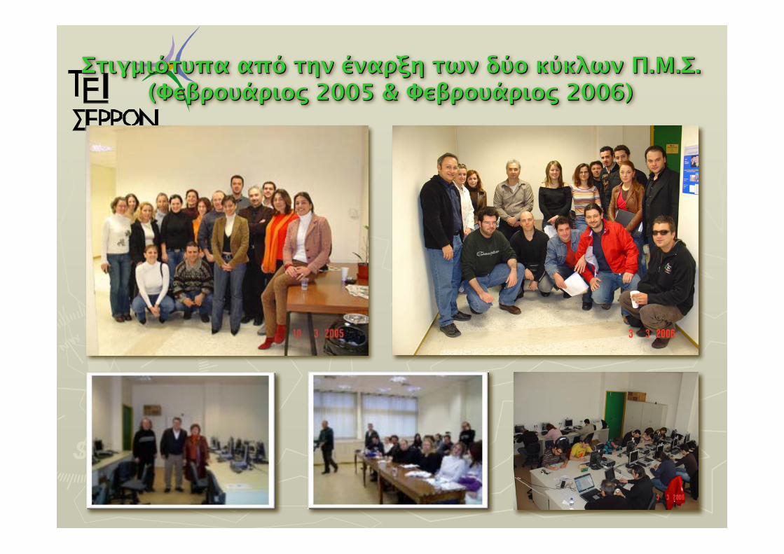
ΣτιγμιότυπαΣτιγμιότυπα απόαπό τηντην έναρξηέναρξη τωντων δύοδύο κύκλωνκύκλων ΠΠ..ΜΜ..ΣΣ..((ΦεβρουάριοςΦεβρουάριος 2005 & 2005 & ΦεβρουάριοςΦεβρουάριος 2006 2006))