ΔΗΜΟΣΙΕΥΣΗ Νο 84 -...
18
ΔΗΜΟΣΙΕΥΣΗ Νο 84 Engineering Geology and the Environment Marinos, Koukis, Tsiambaos and Stournaras(Eds.) 2001 Swets & Zeitlinger, Lisse ISBN 90 5410 882 7 MARIOLAKOS, I., FOUNTOULIS, I., KRANIS, H., (2001). – Geology and tectonics: Sterea Hellas area. Engineering Geology and the Environment, Marinos, Koukis, Tsiambaos and Stournaras(Eds.), 2001 Swets & Zeitlinger, Lisse, ISBN 90 5410 882 7, p. 3971-3986.
Transcript of ΔΗΜΟΣΙΕΥΣΗ Νο 84 -...
ΔΗΜΟΣΙΕΥΣΗ Νο 84
Engineering Geology and the Environment
Marinos, Koukis, Tsiambaos and Stournaras(Eds.)
2001 Swets & Zeitlinger, Lisse ISBN 90 5410 882 7
MARIOLAKOS, I., FOUNTOULIS, I., KRANIS, H., (2001). – Geology and tectonics: Sterea Hellas area. Engineering Geology and the Environment, Marinos, Koukis, Tsiambaos and Stournaras(Eds.), 2001 Swets & Zeitlinger, Lisse, ISBN 90 5410 882 7, p. 3971-3986.
Engineering Geology and the Environment, Marinos, Koukis, Tsiambaos & Stournaras (Eds.) 2001 Swets & Zeitinger, Lisse, ISBN 90 5410 8827
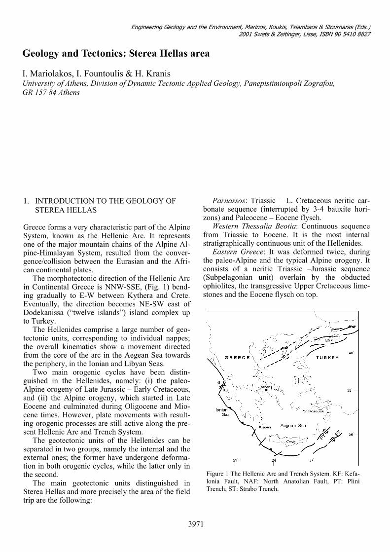
Geology and Tectonics: Sterea Hellas area I. Mariolakos, I. Fountoulis & H. Kranis University of Athens, Division of Dynamic Tectonic Applied Geology, Panepistimioupoli Zografou, GR 157 84 Athens
Parnassos: Triassic – L. Cretaceous neritic car-bonate sequence (interrupted by 3-4 bauxite hori-zons) and Paleocene – Eocene flysch.
1. INTRODUCTION TO THE GEOLOGY OF STEREA HELLAS
Western Thessalia Beotia: Continuous sequence
from Triassic to Eocene. It is the most internal stratigraphically continuous unit of the Hellenides.
Greece forms a very characteristic part of the Alpine System, known as the Hellenic Arc. It represents one of the major mountain chains of the Alpine Al-pine-Himalayan System, resulted from the conver-gence/collision between the Eurasian and the Afri-can continental plates.
Eastern Greece: It was deformed twice, during the paleo-Alpine and the typical Alpine orogeny. It consists of a neritic Triassic –Jurassic sequence (Subpelagonian unit) overlain by the obducted ophiolites, the transgressive Upper Cretaceous lime-stones and the Eocene flysch on top.
The morphotectonic direction of the Hellenic Arc in Continental Greece is NNW-SSE, (Fig. 1) bend-ing gradually to E-W between Kythera and Crete. Eventually, the direction becomes NE-SW east of Dodekanissa (“twelve islands”) island complex up to Turkey.
The Hellenides comprise a large number of geo-tectonic units, corresponding to individual nappes; the overall kinematics show a movement directed from the core of the arc in the Aegean Sea towards the periphery, in the Ionian and Libyan Seas.
Two main orogenic cycles have been distin-guished in the Hellenides, namely: (i) the paleo-Alpine orogeny of Late Jurassic – Early Cretaceous, and (ii) the Alpine orogeny, which started in Late Eocene and culminated during Oligocene and Mio-cene times. However, plate movements with result-ing orogenic processes are still active along the pre-sent Hellenic Arc and Trench System.
The geotectonic units of the Hellenides can be separated in two groups, namely the internal and the external ones; the former have undergone deforma-tion in both orogenic cycles, while the latter only in the second.
The main geotectonic units distinguished in Sterea Hellas and more precisely the area of the field trip are the following:
3971
Figure 1 The Hellenic Arc and Trench System. KF: Kefa-lonia Fault, NAF: North Anatolian Fault, PT: PliniTrench; ST: Strabo Trench.
Engineering Geology and the Environment, Marinos, Koukis, Tsiambaos & Stournaras (Eds.) 2001 Swets & Zeitinger, Lisse, ISBN 90 5410 8827
2. HELLENIC TERRITORY: CURRENT GEODYNAMIC REGIME
The present Hellenic Orogenic Arc is restricted at the southern part of the Hellenic territory, in contrast to all the previous ones, which extended throughout the whole length of the Hellenides.
During the Middle Miocene, a part of the Hel-lenic arc, still active today, was cut off from the Tethyan chain and since then it followed its own evolution. To the north, this part is bounded by the prolongation of the right-lateral Anatolian fault (Fig. 1). In the northern Aegean region, this fault coin-cides with the northern limit of the active part of the Hellenic arc, bounding an area termed “Aegean mi-croplate” (McKenzie, 1970, 1972, 1978, Galanopou-los, 1972).
The present geometry of the Hellenic Arc has been developing since the Late Miocene. The back-arc basin and the volcanic arc are restricted in the Aegean plate region.
According to Le Pichon et al. (1981), the present geodynamic regime of the Hellenic arc is character-ized by asymmetrical movement; along the Ionian
trench, the subduction direction is NE-SW and the regime is pure compression, in accordance with the fault plane solutions while, in the Pliny and Strabo trenches, the direction of movement is composite, featuring a substantial sinistral NNE-SSW horizon-tal component (Fig. 1). In the back-arc area there are extensional structures also with significant horizon-tal component of movement.
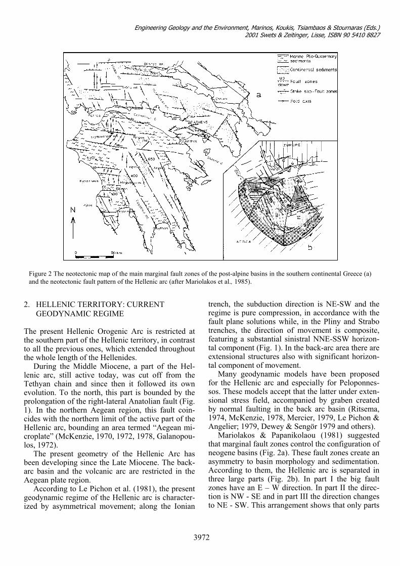
Figure 2 The neotectonic map of the main marginal fault zones of the post-alpine basins in the southern continental Greece (a)and the neotectonic fault pattern of the Hellenic arc (after Mariolakos et al., 1985).
Many geodynamic models have been proposed for the Hellenic arc and especially for Peloponnes-sos. These models accept that the latter under exten-sional stress field, accompanied by graben created by normal faulting in the back arc basin (Ritsema, 1974, McKenzie, 1978, Mercier, 1979, Le Pichon & Angelier; 1979, Dewey & Sengör 1979 and others).
Mariolakos & Papanikolaou (1981) suggested that marginal fault zones control the configuration of neogene basins (Fig. 2a). These fault zones create an asymmetry to basin morphology and sedimentation. According to them, the Hellenic arc is separated in three large parts (Fig. 2b). In part I the big fault zones have an E – W direction. In part II the direc-tion is NW - SE and in part III the direction changes to NE - SW. This arrangement shows that only parts
3972
Engineering Geology and the Environment, Marinos, Koukis, Tsiambaos & Stournaras (Eds.) 2001 Swets & Zeitinger, Lisse, ISBN 90 5410 8827
II and III have apparent dynamic relation to the Hel-lenic arc and trench system, while part I has its own peculiarity.
Figure 4 Seismicity map for the years 1900-1997.
Data on the current deformation pattern of the Hellenic Arc have been provided by numerous re-searchers, as: (i) in situ measurements of the stress field in shallow drillings (<10m), (Paquin et al., 1982); (ii) paleomagnetic investigation of the Neo-gene and Quaternary sediments (Laj et al., 1982); (iii) fault plane solutions (McKenzie 1972, 1978, Ritsema, 1974, Drakopoulos & Delibasis, 1982, Pa-pazachos et al., 1984.
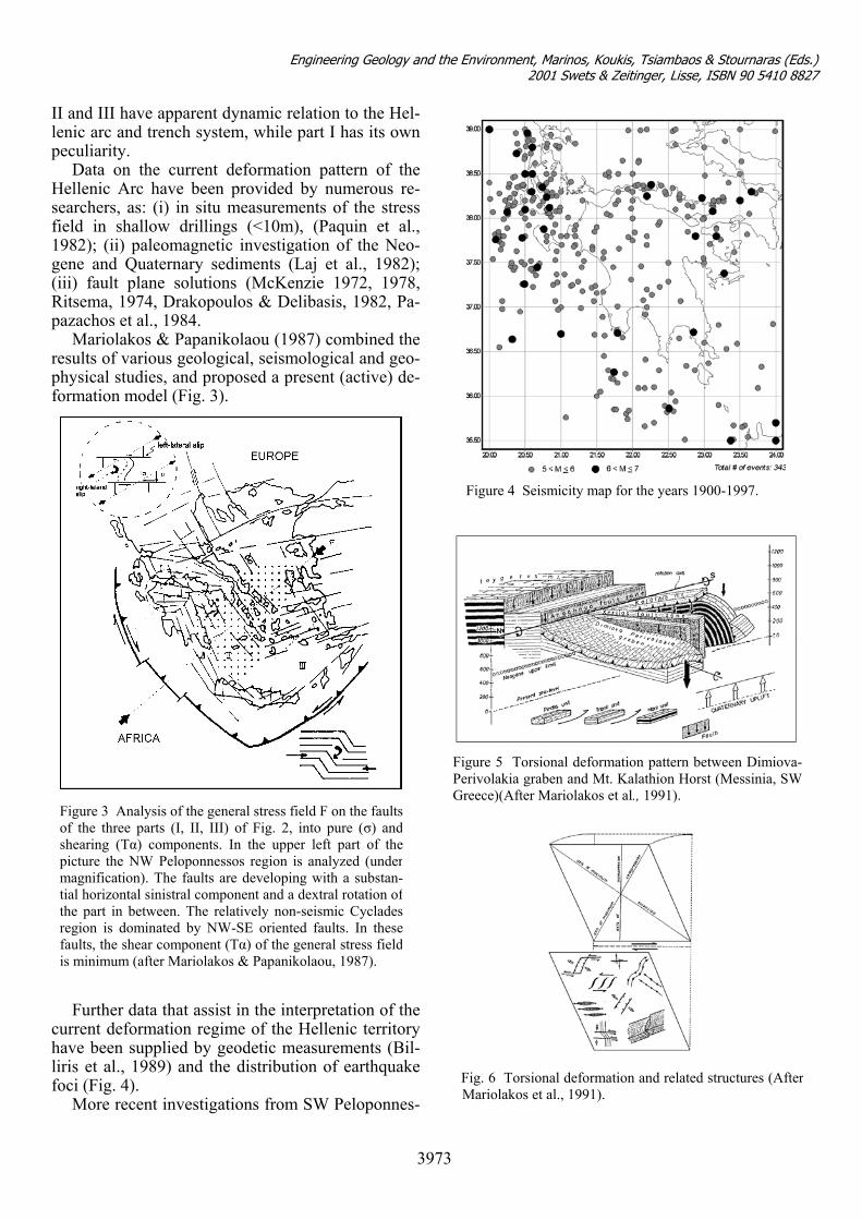
Mariolakos & Papanikolaou (1987) combined the results of various geological, seismological and geo-physical studies, and proposed a present (active) de-formation model (Fig. 3).
Figure 3 Analysis of the general stress field F on the faultsof the three parts (I, II, III) of Fig. 2, into pure (σ) andshearing (Tα) components. In the upper left part of thepicture the NW Peloponnessos region is analyzed (undermagnification). The faults are developing with a substan-tial horizontal sinistral component and a dextral rotation ofthe part in between. The relatively non-seismic Cycladesregion is dominated by NW-SE oriented faults. In thesefaults, the shear component (Tα) of the general stress fieldis minimum (after Mariolakos & Papanikolaou, 1987).
Further data that assist in the interpretation of the
current deformation regime of the Hellenic territory have been supplied by geodetic measurements (Bil-liris et al., 1989) and the distribution of earthquake foci (Fig. 4).
More recent investigations from SW Peloponnes-
3973
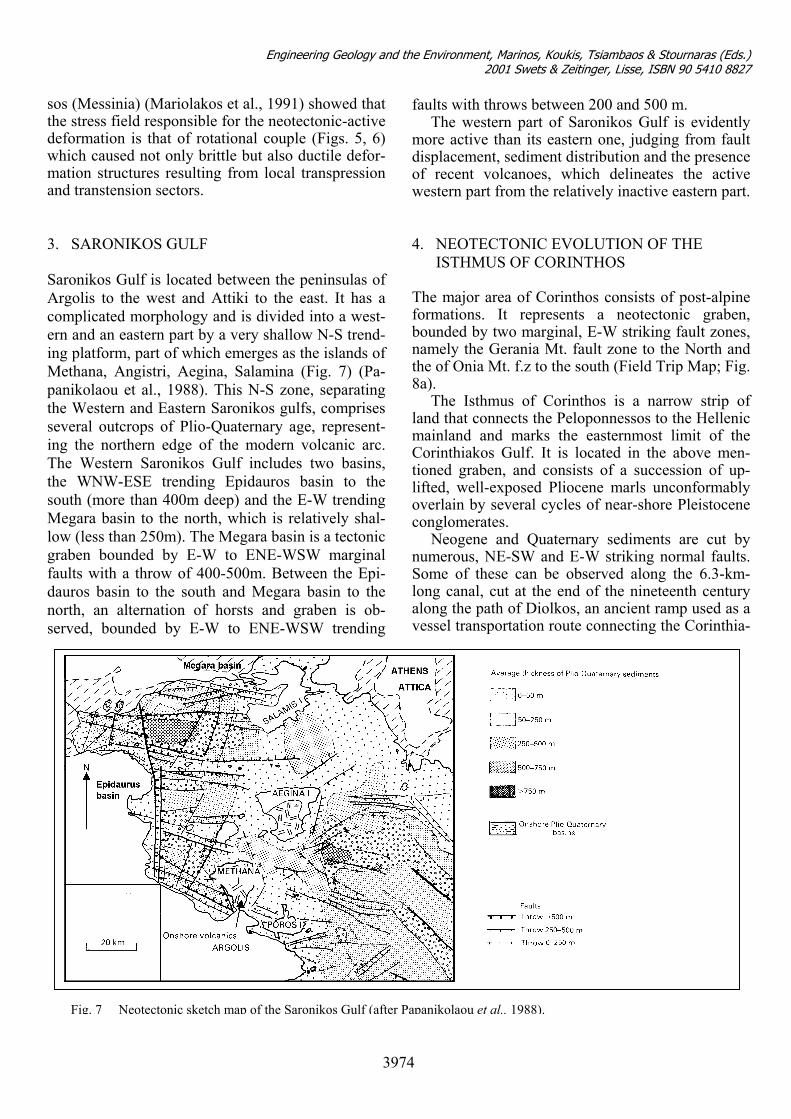
Figure 5 Torsional deformation pattern between Dimiova-Perivolakia graben and Mt. Kalathion Horst (Messinia, SWGreece)(After Mariolakos et al., 1991).
Fig. 6 Torsional deformaMariolakos et al., 1991).
tion and related structures (After
Engineering Geology and the Environment, Marinos, Koukis, Tsiambaos & Stournaras (Eds.) 2001 Swets & Zeitinger, Lisse, ISBN 90 5410 8827
sos (Messinia) (Mariolakos et al., 1991) showed that the stress field responsible for the neotectonic-active deformation is that of rotational couple (Figs. 5, 6) which caused not only brittle but also ductile defor-mation structures resulting from local transpression and transtension sectors.
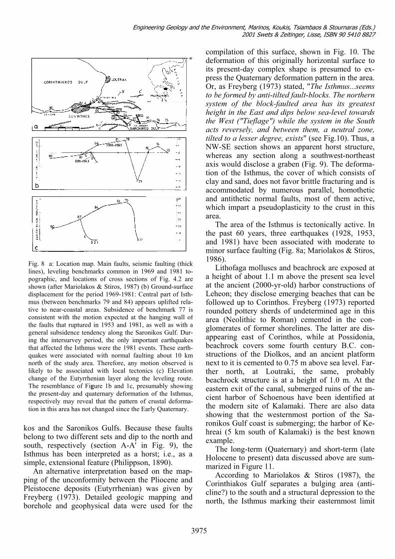
3. SARONIKOS GULF
Saronikos Gulf is located between the peninsulas of Argolis to the west and Attiki to the east. It has a complicated morphology and is divided into a west-ern and an eastern part by a very shallow N-S trend-ing platform, part of which emerges as the islands of Methana, Angistri, Aegina, Salamina (Fig. 7) (Pa-panikolaou et al., 1988). This N-S zone, separating the Western and Eastern Saronikos gulfs, comprises several outcrops of Plio-Quaternary age, represent-ing the northern edge of the modern volcanic arc. The Western Saronikos Gulf includes two basins, the WNW-ESE trending Epidauros basin to the south (more than 400m deep) and the E-W trending Megara basin to the north, which is relatively shal-low (less than 250m). The Megara basin is a tectonic graben bounded by E-W to ENE-WSW marginal faults with a throw of 400-500m. Between the Epi-dauros basin to the south and Megara basin to the north, an alternation of horsts and graben is ob-served, bounded by E-W to ENE-WSW trending
faults with throws between 200 and 500 m. The western part of Saronikos Gulf is evidently
more active than its eastern one, judging from fault displacement, sediment distribution and the presence of recent volcanoes, which delineates the active western part from the relatively inactive eastern part.
4. NEOTECTONIC EVOLUTION OF THE
ISTHMUS OF CORINTHOS The major area of Corinthos consists of post-alpine formations. It represents a neotectonic graben, bounded by two marginal, E-W striking fault zones, namely the Gerania Mt. fault zone to the North and the of Onia Mt. f.z to the south (Field Trip Map; Fig. 8a).
The Isthmus of Corinthos is a narrow strip of land that connects the Peloponnessos to the Hellenic mainland and marks the easternmost limit of the Corinthiakos Gulf. It is located in the above men-tioned graben, and consists of a succession of up-lifted, well-exposed Pliocene marls unconformably overlain by several cycles of near-shore Pleistocene conglomerates.
Neogene and Quaternary sediments are cut by numerous, NE-SW and E-W striking normal faults. Some of these can be observed along the 6.3-km-long canal, cut at the end of the nineteenth century along the path of Diolkos, an ancient ramp used as a vessel transportation route connecting the Corinthia-
.
Fig. 7 Neotectonic sketch map of the Saronikos Gulf (after Papanikolaou et al., 1988)3974
Engineering Geology and the Environment, Marinos, Koukis, Tsiambaos & Stournaras (Eds.) 2001 Swets & Zeitinger, Lisse, ISBN 90 5410 8827
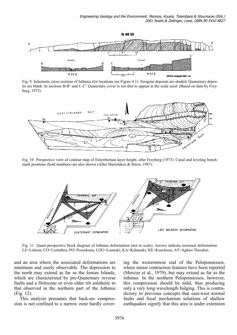
kos and the Saronikos Gulfs. Because these faults belong to two different sets and dip to the north and south, respectively (section A-A' in Fig. 9), the Isthmus has been interpreted as a horst; i.e., as a simple, extensional feature (Philippson, 1890).
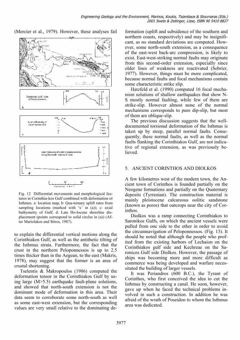
An alternative interpretation based on the map-ping of the unconformity between the Pliocene and Pleistocene deposits (Eutyrrhenian) was given by Freyberg (1973). Detailed geologic mapping and borehole and geophysical data were used for the
compilation of this surface, shown in Fig. 10. The deformation of this originally horizontal surface to its present-day complex shape is presumed to ex-press the Quaternary deformation pattern in the area. Or, as Freyberg (1973) stated, "The Isthmus...seems to be formed by anti-tilted fault-blocks. The northern system of the block-faulted area has its greatest height in the East and dips below sea-level towards the West ("Tieflage") while the system in the South acts reversely, and between them, a neutral zone, tilted to a lesser degree, exists" (see Fig.10). Thus, a NW-SE section shows an apparent horst structure, whereas any section along a southwest-northeast axis would disclose a graben (Fig. 9). The deforma-tion of the Isthmus, the cover of which consists of clay and sand, does not favor brittle fracturing and is accommodated by numerous parallel, homothetic and antithetic normal faults, most of them active, which impart a pseudoplasticity to the crust in this area.
Fig. 8 a: Location map. Main faults, seismic faulting (thicklines), leveling benchmarks common in 1969 and 1981 to-pographic, and locations of cross sections of Fig. 4.2 areshown (after Mariolakos & Stiros, 1987) (b) Ground-surfacedisplacement for the period 1969-1981: Central part of Isth-mus (between benchmarks 79 and 84) appears uplifted rela-tive to near-coastal areas. Subsidence of benchmark 77 isconsistent with the motion expected at the hanging wall ofthe faults that ruptured in 1953 and 1981, as well as with ageneral subsidence tendency along the Saronikos Gulf. Dur-ing the intersurvey period, the only important earthquakesthat affected the Isthmus were the 1981 events. These earth-quakes were associated with normal faulting about 10 kmnorth of the study area. Therefore, any motion observed islikely to be associated with local tectonics (c) Elevationchange of the Eutyrrhenian layer along the leveling route.The resemblance of Figure 1b and 1c, presumably showingthe present-day and quaternary deformation of the Isthmus,respectively may reveal that the pattern of crustal deforma-tion in this area has not changed since the Early Quaternary.
The area of the Isthmus is tectonically active. In the past 60 years, three earthquakes (1928, 1953, and 1981) have been associated with moderate to minor surface faulting (Fig. 8a; Mariolakos & Stiros, 1986).
Lithofaga molluscs and beachrock are exposed at a height of about 1.1 m above the present sea level at the ancient (2000-yr-old) harbor constructions of Leheon; they disclose emerging beaches that can be followed up to Corinthos. Freyberg (1973) reported rounded pottery sherds of undetermined age in this area (Neolithic to Roman) cemented in the con-glomerates of former shorelines. The latter are dis-appearing east of Corinthos, while at Possidonia, beachrock covers some fourth century B.C. con-structions of the Diolkos, and an ancient platform next to it is cemented to 0.75 m above sea level. Far-ther north, at Loutraki, the same, probably beachrock structure is at a height of 1.0 m. At the eastern exit of the canal, submerged ruins of the an-cient harbor of Schoenous have been identified at the modern site of Kalamaki. There are also data showing that the westernmost portion of the Sa-ronikos Gulf coast is submerging; the harbor of Ke-hreai (5 km south of Kalamaki) is the best known example.
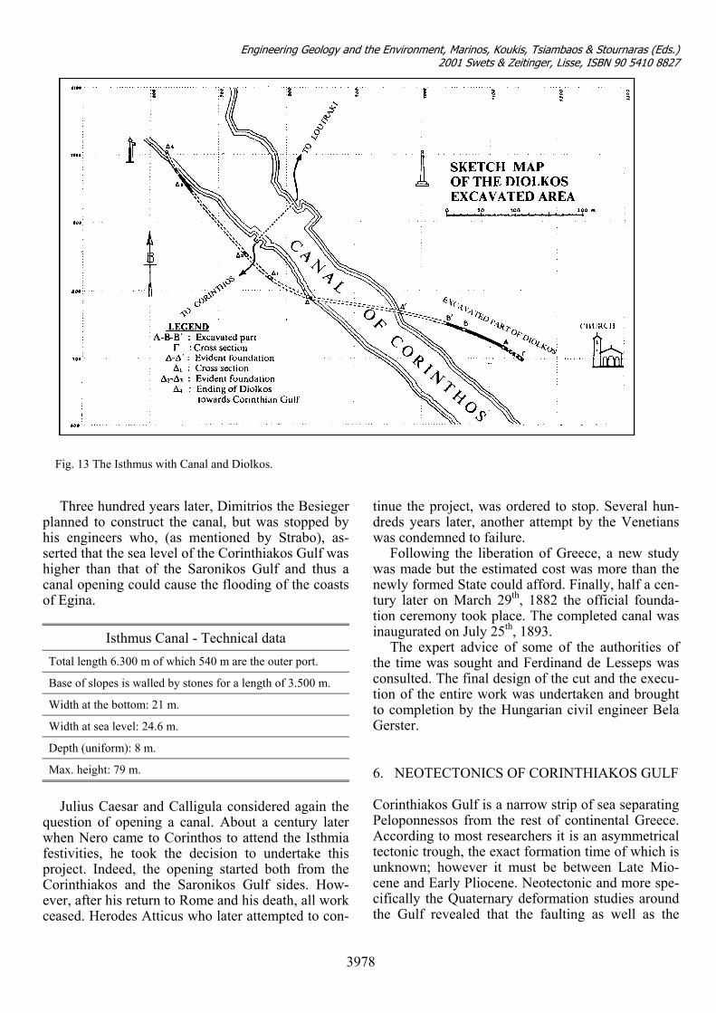
The long-term (Quaternary) and short-term (late Holocene to present) data discussed above are sum-marized in Figure 11.
According to Mariolakos & Stiros (1987), the Corinthiakos Gulf separates a bulging area (anti-cline?) to the south and a structural depression to the north, the Isthmus marking their easternmost limit
3975
Engineering Geology and the Environment, Marinos, Koukis, Tsiambaos & Stournaras (Eds.) 2001 Swets & Zeitinger, Lisse, ISBN 90 5410 8827
and an area where the associated deformations are minimum and easily observable. The depression to the north may extend as far as the Ionian Islands, which are characterized by pre-Quaternary reverse faults and a Holocene or even older tilt antithetic to that observed in the northern part of the Isthmus (Fig. 12).
This analysis presumes that back-arc compres-sion is not confined to a narrow zone hardly cover-
ing the westernmost end of the Peloponnessos, where minor contraction features have been reported (Mercier et al., 1979), but may extend as far as the isthmus. In the northern Peloponnessos, however, this compression should be mild, thus producing only a very long wavelength bulging. This is contra-dictory to previous concepts that east-west normal faults and focal mechanism solutions of shallow earthquakes signify that this area is under extension
Fig. 9 Schematic cross sections of Isthmus (for locations see Figure 4.1). Neogene deposits are shaded, Quaternary depos-its are blank. In sections B-B’ and C-C’ Quaternary cover is too thin to appear at the scale used. (Based on data by Frey-berg, 1973).
Fig. 10 Perspective view of contour map of Eutyrrhenian layer height, after Freyberg (1973). Canal and leveling bench-mark positions (bold numbers) are also shown (After Mariolakos & Stiros, 1987).
Fig. 11 Quasi-perspective block diagram of Isthmus deformation (not to scale). Arrows indicate torsional deformation.LE=Leheon; CO=Corinthos; PO=Possidonia; LOU=Loutraki; KA=Kalamaki; KE=Kenchreai; AT=Aghioi Theodori.
3976
Engineering Geology and the Environment, Marinos, Koukis, Tsiambaos & Stournaras (Eds.) 2001 Swets & Zeitinger, Lisse, ISBN 90 5410 8827
(Mercier et al., 1979). However, these analyses fail
toCthcti1c
dinaddav
formation (uplift and subsidence of the southern and northern coasts, respectively) and may be insignifi-cant, as no standard deviations are computed. How-ever, some north-south extension, as a consequence of the east-west back-arc compression, is likely to exist. East-west-striking normal faults may originate from this second-order extension, especially since older lines of weakness are reactivated (Sebrier, 1977). However, things must be more complicated, because normal faults and focal mechanisms contain some characteristic strike slip.
Hatzfeld et al. (1990) computed 16 focal mecha-nism solutions of shallow earthquakes that show N-S mostly normal faulting, while few of them are strike-slip. However almost none of the normal mechanisms corresponds to pure dip-slip, but most of them are oblique-slip.
The previous discussion suggests that the well-documented torsional deformation of the Isthmus is taken up by steep, parallel normal faults. Conse-quently, these normal faults, as well as the normal faults flanking the Corinthiakos Gulf, are not indica-tive of regional extension, as was previously be-lieved. 5. ANCIENT CORINTHOS AND DIOLKOS A few kilometres west of the modern town, the An-cient town of Corinthos is founded partially on the Neogene formations and partially on the Quaternary deposits (Tyrrenian). The construction material is mainly pleistocene calcareous oolitic sandstone (known as poros) that outcrops near the city of Cor-inthos.
Diolkos was a ramp connecting Corinthiakos to Saronikos Gulfs, on which the ancient vessels were
Fig. 12 Differential movements and morphological fea-tures in Corinthia-kos Gulf combined with deformation ofIsthmus. a: location map, b: Qua-ternary uplift rates fromsampling locations (marked with ‘x’ in (a)); c: axialbathymetry of Gulf; d: Late Ho-locene shoreline dis-placement (points correspond to solid circles in (a)) (Af-ter Mariolakos and Stiros, 1987).
explain the differential vertical motions along the orinthiakos Gulf, as well as the antithetic tilting of e Isthmus strata. Furthermore, the fact that the
rust in the northern Peloponnessos is up to 2.5 mes thicker than in the Aegean, to the east (Makris, 978), may suggest that the former is an area of rustal shortening.
Tselentis & Makropoulos (1986) computed the eformation tensor in the Corinthiakos Gulf by us-g large (M>5.5) earthquake fault-plane solutions,
nd showed that north-south extension is not the ominant mode of deformation in this area. Their ata seem to corroborate some north-south as well s some east-west extension, but the corresponding alues are very small relative to the dominating de-
pulled from one side to the other in order to avoid the circumnavigation of Peloponnessos. (Fig. 13). It should be noted that although the people who prof-ited from the existing harbors of Lechaion on the Corinthiakos gulf side and Kechreae on the Sa-ronicos Gulf side Diolkos. However, the passage of ships was becoming more and more difficult as commerce was being developed and warfare neces-sitated the building of larger vessels.
It was Periandros (600 B.C.), the Tyrant of Corinthos, who first conceived the idea to cut the Isthmus by constructing a canal. He soon, however, gave up when he faced the technical problems in-volved in such a construction. In addition he was afraid of the wrath of Poseidon to whom the Isthmus area was dedicated.
3977
Engineering Geology and the Environment, Marinos, Koukis, Tsiambaos & Stournaras (Eds.) 2001 Swets & Zeitinger, Lisse, ISBN 90 5410 8827
Fig. 13 The Isthmus with Canal and Diolkos.
Three hundred years later, Dimitrios the Besieger planned to construct the canal, but was stopped by his engineers who, (as mentioned by Strabo), as-serted that the sea level of the Corinthiakos Gulf was higher than that of the Saronikos Gulf and thus a canal opening could cause the flooding of the coasts of Egina.
Isthmus Canal - Technical data
Total length 6.300 m of which 540 m are the outer port.
Base of slopes is walled by stones for a length of 3.500 m.
Width at the bottom: 21 m.
Width at sea level: 24.6 m.
Depth (uniform): 8 m.
Max. height: 79 m.
Julius Caesar and Calligula considered again the
question of opening a canal. About a century later when Nero came to Corinthos to attend the Isthmia festivities, he took the decision to undertake this project. Indeed, the opening started both from the Corinthiakos and the Saronikos Gulf sides. How-ever, after his return to Rome and his death, all work ceased. Herodes Atticus who later attempted to con-
tinue the project, was ordered to stop. Several hun-dreds years later, another attempt by the Venetians was condemned to failure.
Following the liberation of Greece, a new study was made but the estimated cost was more than the newly formed State could afford. Finally, half a cen-tury later on March 29th, 1882 the official founda-tion ceremony took place. The completed canal was inaugurated on July 25th, 1893.
The expert advice of some of the authorities of the time was sought and Ferdinand de Lesseps was consulted. The final design of the cut and the execu-tion of the entire work was undertaken and brought to completion by the Hungarian civil engineer Bela Gerster. 6. NEOTECTONICS OF CORINTHIAKOS GULF Corinthiakos Gulf is a narrow strip of sea separating Peloponnessos from the rest of continental Greece. According to most researchers it is an asymmetrical tectonic trough, the exact formation time of which is unknown; however it must be between Late Mio-cene and Early Pliocene. Neotectonic and more spe-cifically the Quaternary deformation studies around the Gulf revealed that the faulting as well as the
3978
Engineering Geology and the Environment, Marinos, Koukis, Tsiambaos & Stournaras (Eds.) 2001 Swets & Zeitinger, Lisse, ISBN 90 5410 8827
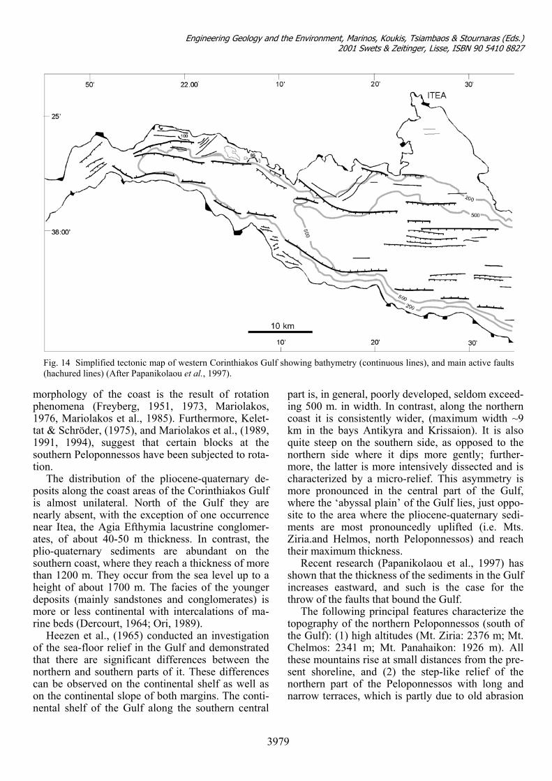
Fig. 14 Simplified tectonic map of western Corinthiakos Gulf showing bathymetry (continuous lines), and main active faults(hachured lines) (After Papanikolaou et al., 1997).
morphology of the coast is the result of rotation phenomena (Freyberg, 1951, 1973, Mariolakos, 1976, Mariolakos et al., 1985). Furthermore, Kelet-tat & Schröder, (1975), and Mariolakos et al., (1989, 1991, 1994), suggest that certain blocks at the southern Peloponnessos have been subjected to rota-tion.
The distribution of the pliocene-quaternary de-posits along the coast areas of the Corinthiakos Gulf is almost unilateral. North of the Gulf they are nearly absent, with the exception of one occurrence near Itea, the Agia Efthymia lacustrine conglomer-ates, of about 40-50 m thickness. In contrast, the plio-quaternary sediments are abundant on the southern coast, where they reach a thickness of more than 1200 m. They occur from the sea level up to a height of about 1700 m. The facies of the younger deposits (mainly sandstones and conglomerates) is more or less continental with intercalations of ma-rine beds (Dercourt, 1964; Ori, 1989).
Heezen et al., (1965) conducted an investigation of the sea-floor relief in the Gulf and demonstrated that there are significant differences between the northern and southern parts of it. These differences can be observed on the continental shelf as well as on the continental slope of both margins. The conti-nental shelf of the Gulf along the southern central
part is, in general, poorly developed, seldom exceed-ing 500 m. in width. In contrast, along the northern coast it is consistently wider, (maximum width ~9 km in the bays Antikyra and Krissaion). It is also quite steep on the southern side, as opposed to the northern side where it dips more gently; further-more, the latter is more intensively dissected and is characterized by a micro-relief. This asymmetry is more pronounced in the central part of the Gulf, where the ‘abyssal plain’ of the Gulf lies, just oppo-site to the area where the pliocene-quaternary sedi-ments are most pronouncedly uplifted (i.e. Mts. Ziria.and Ηelmos, north Peloponnessos) and reach their maximum thickness.
Recent research (Papanikolaou et al., 1997) has shown that the thickness of the sediments in the Gulf increases eastward, and such is the case for the throw of the faults that bound the Gulf.
The following principal features characterize the topography of the northern Peloponnessos (south of the Gulf): (1) high altitudes (Mt. Ziria: 2376 m; Mt. Chelmos: 2341 m; Mt. Panahaikon: 1926 m). All these mountains rise at small distances from the pre-sent shoreline, and (2) the step-like relief of the northern part of the Peloponnessos with long and narrow terraces, which is partly due to old abrasion
3979
Engineering Geology and the Environment, Marinos, Koukis, Tsiambaos & Stournaras (Eds.) 2001 Swets & Zeitinger, Lisse, ISBN 90 5410 8827
that followed the deposition of recent marine sedi-ments.
The valleys of the northern Peloponnessos are deeply incised and steep gradients are another char-acteristic of the thalwegs. The geomorphology of the northern margin is completely different and the area occupied by the mountains Parnassos and Giona consists of four erosion surfaces. (Maul, 1921, Philippson, 1930, Sweeting, 1967). The step-like arrangement of the relief, which is so characteristic of the Northern Peloponnessos topography, is absent here. Furthermore, with very few exceptions, the streams of the northern margin are not incised.
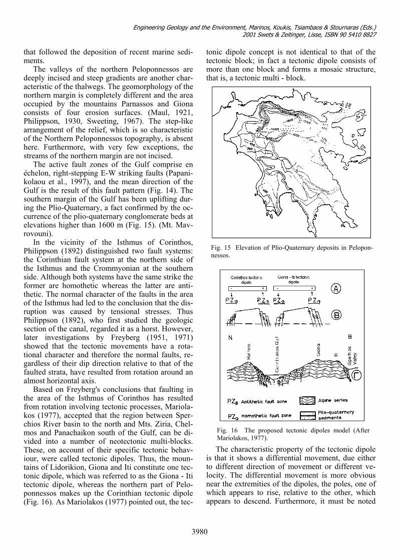
The active fault zones of the Gulf comprise en échelon, right-stepping E-W striking faults (Papani-kolaou et al., 1997), and the mean direction of the Gulf is the result of this fault pattern (Fig. 14). The southern margin of the Gulf has been uplifting dur-ing the Plio-Quaternary, a fact confirmed by the oc-currence of the plio-quaternary conglomerate beds at elevations higher than 1600 m (Fig. 15). (Mt. Mav-rovouni).
In the vicinity of the Isthmus of Corinthos, Philippson (1892) distinguished two fault systems: the Corinthian fault system at the northern side of the Isthmus and the Crommyonian at the southern side. Although both systems have the same strike the former are homothetic whereas the latter are anti-thetic. The normal character of the faults in the area of the Isthmus had led to the conclusion that the dis-ruption was caused by tensional stresses. Thus Philippson (1892), who first studied the geologic section of the canal, regarded it as a horst. However, later investigations by Freyberg (1951, 1971) showed that the tectonic movements have a rota-tional character and therefore the normal faults, re-gardless of their dip direction relative to that of the faulted strata, have resulted from rotation around an almost horizontal axis.
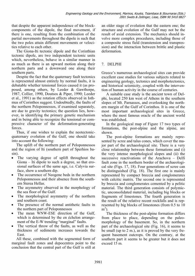
Based on Freyberg's conclusions that faulting in the area of the Isthmus of Corinthos has resulted from rotation involving tectonic processes, Mariola-kos (1977), accepted that the region between Sper-chios River basin to the north and Mts. Ziria, Chel-mos and Panachaikon south of the Gulf, can be di-vided into a number of neotectonic multi-blocks. These, on account of their specific tectonic behav-iour, were called tectonic dipoles. Thus, the moun-tains of Lidorikion, Giona and Iti constitute one tec-tonic dipole, which was referred to as the Giona - Iti tectonic dipole, whereas the northern part of Pelo-ponnessos makes up the Corinthian tectonic dipole (Fig. 16). As Mariolakos (1977) pointed out, the tec-
tonic dipole concept is not identical to that of the tectonic block; in fact a tectonic dipole consists of more than one block and forms a mosaic structure, that is, a tectonic multi - block.
The characteristic property of the tectonic dipole is that it shows a differential movement, due either to different direction of movement or different ve-locity. The differential movement is more obvious near the extremities of the dipoles, the poles, one of which appears to rise, relative to the other, which appears to descend. Furthermore, it must be noted
Fig. 16 The proposed tectonic dipoles model (After Mariolakos, 1977).
Fig. 15 Elevation of Plio-Quaternary deposits in Pelopon-nessos.
3980
Engineering Geology and the Environment, Marinos, Koukis, Tsiambaos & Stournaras (Eds.) 2001 Swets & Zeitinger, Lisse, ISBN 90 5410 8827
that despite the apparent independence of the block-components of the dipole, the final movement, if there is one, resulting from the combination of the partial movements throughout the dipole is such that the two poles attain different movements or veloci-ties relative to each other.
The Giona-Iti tectonic dipole and the Corinthian tectonic dipole, are two independent tectonic units which, nevertheless, behave in a similar manner in as much as there is an upward motion along their northern parts and a downward one along their southern parts.
Despite the fact that the quaternary fault tectonics is represented almost entirely by normal faults, it is debatable whether tensional forces caused it (as pro-posed, among others, by Leeder & Gawthorpe, 1987, Collier, 1990, Doutsos & Piper, 1990; Leeder et al., 1991) as the rotation effects observed in Isth-mus of Corinthos suggest. Undoubtedly, the faults of the northern Peloponnessos, if examined separately, are due to gravity tectonics; the question lies, how-ever, in identifying the primary genetic mechanism and in being able to recognize the tensional or com-pressive character of the deformation-generating forces.
Thus, if one wishes to explain the neotectonic-quaternary evolution of the Gulf, one should take into account the following:
The uplift of the northern part of Peloponnessos and the region of Iti (southern part of Sperhios ba-sin). • The varying degree of uplift throughout the
Giona – Iti dipole to such a degree, so that ero-sional surfaces of the same age, i.e. Calyvia sur-face, show a southern dip.
• The occurrence of Neogene beds in the northern Peloponnessos and their absence from the south-ern Sterea Hellas.
• The asymmetry observed in the morphology of the sea floor of the Gulf.
• The morphological asymmetry of the northern and southern coast.
• The presence of the normal antithetic faults in the northern part of Peloponnessos
• The mean WNW-ESE direction of the Gulf, which is determined by the en échelon arrange-ment of the E-W trending “marginal” faults.
• The vertical throw of the faults, as well as the thickness of sediments increases towards the East. All these, combined with the segmented form of
marginal fault zones and depocentres point to the conclusion that the central part of the Gulf is still at
an older stage of evolution that the eastern one; the structure and evolution of the Gulf may not be the result of axial extension. The mechanics should in-volve more complex procedures, including those of a composite stress field (transtension and transpres-sion) and the interaction between brittle and plastic deformation. 7. DELPHI Greece’s numerous archaeological sites can provide excellent case studies for various subjects related to engineering geology, tectonics and morphotectonics, and historical seismicity, coupled with the interven-tion of human activity in the course of centuries.
A suitable case study is the ancient town of Del-phi, located 250 km west of Athens in the southern slopes of Mt. Parnassos, and overlooking the north-ern margin of the Gulf of Corinthos. It is one of the most important archaeological sites in Greece, where the most famous oracle of the ancient world was established.
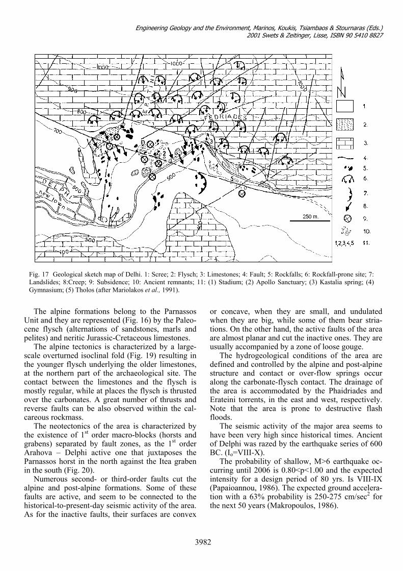
In the geological map of Figure 17 two types of formations, the post-alpine and the alpine, are shown.
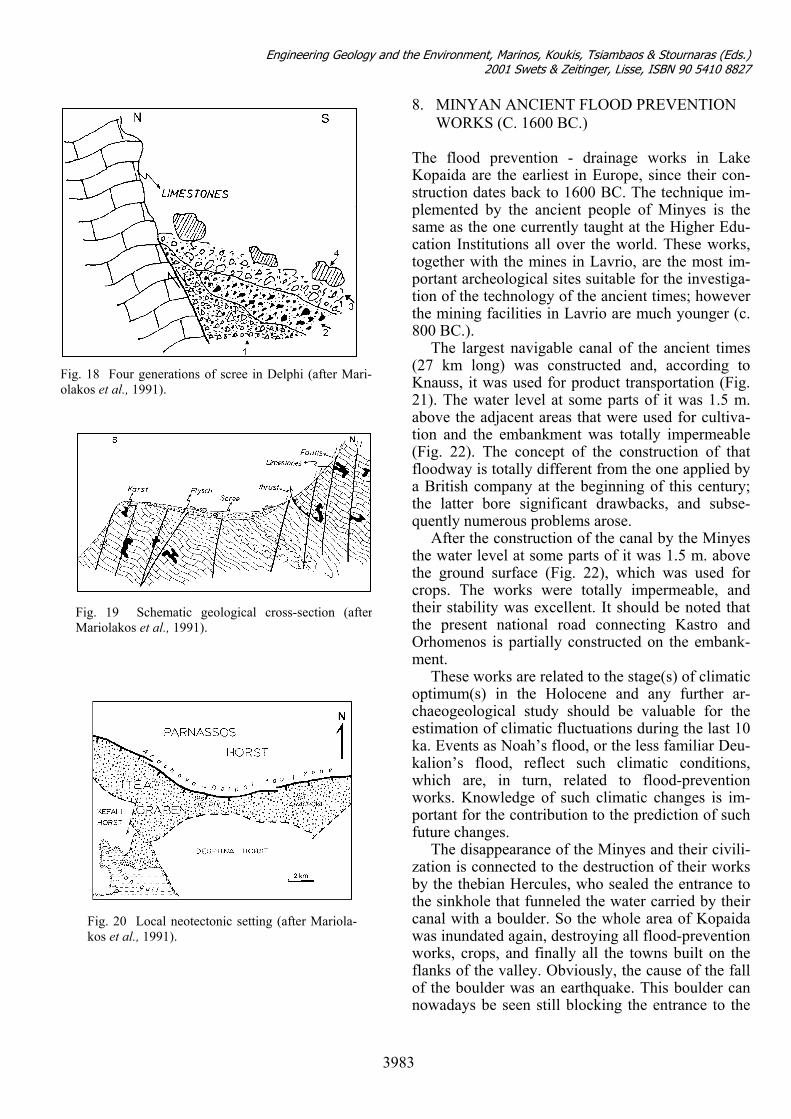
The post-alpine formations are mainly repre-sented by scree and talus cones, which cover the ma-jor part of the archaeological site. There is a very close relationship between these formations and (i) the very intense morphological slopes and (ii) the successive reactivations of the Arachova – Delfi fault zone in the northern border of the archaeologi-cal site (Figs. 17, 18). Four generations of scree can be distinguished (Fig. 18). The first one is mainly represented by compact breccia and conglomerates with calcitic matrix. The second one is represented by breccia and conglomerates cemented by a pelitic material. The third generation consists of polymic-tic, unconsolidated material, including big blocks or fragments of limestones. The fourth generation is the result of the relative recent rockfalls and is rep-resented by big blocks of limestones (from 0.5 to 10 m3).
The thickness of the post-alpine formation differs from place to place, depending on the paleo-morphology of the basement. So, in the northern part of the archaeological site (Fig. 16), it seems to be small (up to 2 m.), as it is proved by the very fre-quent basement outcrops. On the contrary, at the southern part it seems to be greater but it does not exceed 15 m.
3981
Engineering Geology and the Environment, Marinos, Koukis, Tsiambaos & Stournaras (Eds.) 2001 Swets & Zeitinger, Lisse, ISBN 90 5410 8827
Ucp
stacmorc
tgAPi
afhA
Fig. 17 Geological sketch map of Delhi. 1: Scree; 2: Flysch; 3: Limestones; 4: Fault; 5: Rockfalls; 6: Rockfall-prone site; 7: Landslides; 8:Creep; 9: Subsidence; 10: Ancient remnants; 11: (1) Stadium; (2) Apollo Sanctuary; (3) Kastalia spring; (4) Gymnasium; (5) Tholos (after Mariolakos et al., 1991).
The alpine formations belong to the Parnassos nit and they are represented (Fig. 16) by the Paleo-
ene flysch (alternations of sandstones, marls and elites) and neritic Jurassic-Cretaceous limestones.
The alpine tectonics is characterized by a large-cale overturned isoclinal fold (Fig. 19) resulting in he younger flysch underlying the older limestones, t the northern part of the archaeological site. The ontact between the limestones and the flysch is ostly regular, while at places the flysch is thrusted
ver the carbonates. A great number of thrusts and everse faults can be also observed within the cal-areous rockmass.
The neotectonics of the area is characterized by he existence of 1st order macro-blocks (horsts and rabens) separated by fault zones, as the 1st order rahova – Delphi active one that juxtaposes the arnassos horst in the north against the Itea graben
n the south (Fig. 20). Numerous second- or third-order faults cut the
lpine and post-alpine formations. Some of these aults are active, and seem to be connected to the istorical-to-present-day seismic activity of the area. s for the inactive faults, their surfaces are convex
or concave, when they are small, and undulated when they are big, while some of them bear stria-tions. On the other hand, the active faults of the area are almost planar and cut the inactive ones. They are usually accompanied by a zone of loose gouge.
The hydrogeological conditions of the area are defined and controlled by the alpine and post-alpine structure and contact or over-flow springs occur along the carbonate-flysch contact. The drainage of the area is accommodated by the Phaidriades and Erateini torrents, in the east and west, respectively. Note that the area is prone to destructive flash floods.
The seismic activity of the major area seems to have been very high since historical times. Ancient of Delphi was razed by the earthquake series of 600 BC. (Io=VIII-X).
The probability of shallow, M>6 earthquake oc-curring until 2006 is 0.80<p<1.00 and the expected intensity for a design period of 80 yrs. Is VIII-IX (Papaioannou, 1986). The expected ground accelera-tion with a 63% probability is 250-275 cm/sec2 for the next 50 years (Makropoulos, 1986).
3982
Engineering Geology and the Environment, Marinos, Koukis, Tsiambaos & Stournaras (Eds.) 2001 Swets & Zeitinger, Lisse, ISBN 90 5410 8827
8. MINYAN ANCIENT FLOOD PREVENTION WORKS (C. 1600 BC.)
Fig. 18 Four generations of scree in Delphi (after Mari-olakos et al., 1991).
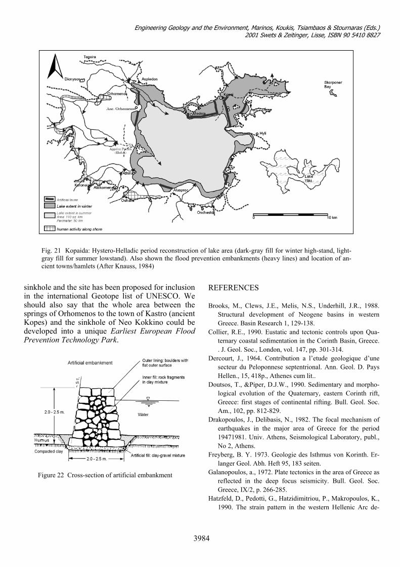
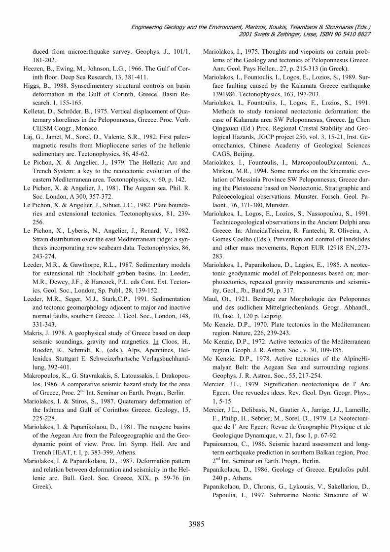
The flood prevention - drainage works in Lake Kopaida are the earliest in Europe, since their con-struction dates back to 1600 BC. The technique im-plemented by the ancient people of Minyes is the same as the one currently taught at the Higher Edu-cation Institutions all over the world. These works, together with the mines in Lavrio, are the most im-portant archeological sites suitable for the investiga-tion of the technology of the ancient times; however the mining facilities in Lavrio are much younger (c. 800 BC.).
The largest navigable canal of the ancient times (27 km long) was constructed and, according to Knauss, it was used for product transportation (Fig. 21). The water level at some parts of it was 1.5 m. above the adjacent areas that were used for cultiva-tion and the embankment was totally impermeable (Fig. 22). The concept of the construction of that floodway is totally different from the one applied by a British company at the beginning of this century; the latter bore significant drawbacks, and subse-quently numerous problems arose.
Fig. 19 Schematic geological cross-section (afterMariolakos et al., 1991).
After the construction of the canal by the Minyes the water level at some parts of it was 1.5 m. above the ground surface (Fig. 22), which was used for crops. The works were totally impermeable, and their stability was excellent. It should be noted that the present national road connecting Kastro and Orhomenos is partially constructed on the embank-ment.
These works are related to the stage(s) of climatic optimum(s) in the Holocene and any further ar-chaeogeological study should be valuable for the estimation of climatic fluctuations during the last 10 ka. Events as Noah’s flood, or the less familiar Deu-kalion’s flood, reflect such climatic conditions, which are, in turn, related to flood-prevention works. Knowledge of such climatic changes is im-portant for the contribution to the prediction of such future changes.
Fig. 20 Local neotectonic setting (after Mariola-kos et al., 1991).
The disappearance of the Minyes and their civili-zation is connected to the destruction of their works by the thebian Hercules, who sealed the entrance to the sinkhole that funneled the water carried by their canal with a boulder. So the whole area of Kopaida was inundated again, destroying all flood-prevention works, crops, and finally all the towns built on the flanks of the valley. Obviously, the cause of the fall of the boulder was an earthquake. This boulder can nowadays be seen still blocking the entrance to the
3983
Engineering Geology and the Environment, Marinos, Koukis, Tsiambaos & Stournaras (Eds.) 2001 Swets & Zeitinger, Lisse, ISBN 90 5410 8827
sinkhin thshoulsprinKopedevelPreve
F
ole and the site has been proposed for inclusion e international Geotope list of UNESCO. We d also say that the whole area between the gs of Orhomenos to the town of Kastro (ancient s) and the sinkhole of Neo Kokkino could be oped into a unique Earliest European Flood ntion Technology Park.
REFERENCES Brooks, M., Clews, J.E., Melis, N.S., Underhill, J.R., 1988.
Structural development of Neogene basins in western Greece. Basin Research 1, 129-138.
Collier, R.E., 1990. Eustatic and tectonic controls upon Qua-ternary coastal sedimentation in the Corinth Basin, Greece. . J. Geol. Soc., London, vol. 147, pp. 301-314.
Dercourt, J., 1964. Contribution a l’etude geologique d’une secteur du Peloponnese septentrional. Ann. Geol. D. Pays
Fig. 21 Kopaida: Hystero-Helladic period reconstruction of lake area (dark-gray fill for winter high-stand, light-gray fill for summer lowstand). Also shown the flood prevention embankments (heavy lines) and location of an-cient towns/hamlets (After Knauss, 1984)
Hellen., 15, 418p., Athenes cum lit..
igure 22 Cross-section of artificial embankment
Doutsos, T., &Piper, D.J.W., 1990. Sedimentary and morpho-logical evolution of the Quaternary, eastern Corinth rift, Greece: first stages of continental rifting. Bull. Geol. Soc. Am., 102, pp. 812-829.
Drakopoulos, J., Delibasis, N., 1982. The focal mechanism of earthquakes in the major area of Greece for the period 19471981. Univ. Athens, Seismological Laboratory, publ., No 2, Athens.
Freyberg, B. Y. 1973. Geologie des Isthmus von Korinth. Er-langer Geol. Abh. Heft 95, 183 seiten.
Galanopoulos, a., 1972. Plate tectonics in the area of Greece as reflected in the deep focus seismicity. Bull. Geol. Soc. Greece, IX/2, p. 266-285.
Hatzfeld, D., Pedotti, G., Hatzidimitriou, P., Makropoulos, K., 1990. The strain pattern in the western Hellenic Arc de-
3984
Engineering Geology and the Environment, Marinos, Koukis, Tsiambaos & Stournaras (Eds.) 2001 Swets & Zeitinger, Lisse, ISBN 90 5410 8827
duced from microerthquake survey. Geophys. J., 101/1, 181-202.
Heezen, B., Ewing, M., Johnson, L.G., 1966. The Gulf of Cor-inth floor. Deep Sea Research, 13, 381-411.
Higgs, B., 1988. Synsedimentery structural controls on basin deformation in the Gulf of Corinth, Greece. Basin Re-search. 1, 155-165.
Kelletat, D., Schröder, B., 1975. Vertical displacement of Qua-ternary shorelines in the Peloponnesus, Greece. Proc. Verb. CIESM Congr., Monaco.
Laj, G., Jamet, M., Sorel, D., Valente, S.R., 1982. First paleo-magnetic results from Miopliocene series of the hellenic sedimentary arc. Tectonophysics, 86, 45-62.
Le Pichon, X. & Angelier, J., 1979. The Hellenic Arc and Trench System: a key to the neotectonic evolution of the eastern Mediterranean area. Tectonophysics, v. 60, p. 142.
Le Pichon, X. & Angelier, J., 1981. The Aegean sea. Phil. R. Soc. London, A 300, 357-372.
Le Pichon, X. & Angelier, J., Sibuet, J.C., 1982. Plate bounda-ries and extensional tectonics. Tectonophysics, 81, 239-256.
Le Pichon, X., Lyberis, N., Angelier, J., Renard, V., 1982. Strain distribution over the east Mediterranean ridge: a syn-thesis incorporating new seabeam data. Tectonophysics, 86, 243-274.
Leeder, M.R., & Gawthorpe, R.L., 1987. Sedimentary models for extensional tilt block/half graben basins. In: Leeder, M.R., Dewey, J.F., & Hancock, P.L. eds Cont. Ext. Tecton-ics. Geol. Soc., London, Sp. Publ., 28, 139-152.
Leeder, M.R., Seger, M.J., Stark,C.P., 1991. Sedimentation and tectonic geomorphology adjacent to major and inactive normal faults, southern Greece. J. Geol. Soc., London, 148, 331-343.
Makris, J. 1978. A geophysical study of Greece based on deep seismic soundings, gravity and magnetics. In Cloos, H., Roeder, R., Schmidt, K., (eds.), Alps, Apennines, Hel-lenides. Stuttgart E. Schweizerbartsche Verlagsbuchhand-lung, 392-401.
Makropoulos, K., G. Stavrakakis, S. Latoussakis, I. Drakopou-los, 1986. A comparative seismic hazard study for the area of Greece, Proc. 2nd Int. Seminar on Earth. Progn., Berlin. riolakos, I. & SMa tiros, S., 1987. Quaternary deformation of
Ma . & Papanikolaou, D., 1981. The neogene basins
Ma eformation pattern
Ma I., Fountoulis, I., Logos, E., Lozios, S., 1989. Sur-
Ma os, S., 1991.
Mariolakos, I., 1975. Thoughts and viepoints on certain prob-lems of the Geology and tectonics of Peloponnesus Greece. Ann. Geol. Pays Hellen.. 27, p. 215-313 (in Greek). riolakos, face faulting caused by the Kalamata Greece earthquake 1391986. Tectonophysics, 163, 197-203. riolakos, I., Fountoulis, I., Logos, E., LoziMethods to study torsional neotectonic deformation: the case of Kalamata area SW Peloponnesus, Greece. In Chen Qingxuan (Ed.) Proc. Regional Crustal Stability and Geo-logical Hazards, ,IGCP project 250, vol. 3, 15-21, Inst. Ge-omechanics, Chinese Academy of Geological Sciences CAGS, Beijing.
Mariolakos, I., Fountoulis, I., MarcopoulouDiacantoni, A.,
Ma ., Nassopoulou, S., 1991.
Ma os, I., Papanikolaou, D., Lagios, E., 1985. A neotec-
Ma ie des Peloponnes
Mc tectonics in the Mediterranean
Mc ctonics of the Mediterranean
Mc lpineHi-
Me l' Arc
Me ., Delibasis, N., Gautier A., Jarrige, J.J., Lameille,
Pap earthquake prediction in southern Balkan region, Proc.
Pap
97. Submarine Neotic Structure of W.
Mirkou, M.R., 1994. Some remarks on the kinematic evo-lution of Messinia Province SW Peloponnesus, Greece dur-ing the Pleistocene based on Neotectonic, Stratigraphic and Paleoecological observations. Munster. Forsch. Geol. Pa-laont., 76, 371-380, Munster. riolakos, I., Logos, E., Lozios, STechnicogeological observations in the Ancient Delphi area Greece. In: AlmeidaTeixeira, R. Fantechi, R. Oliveira, A. Gomes Coelho (Eds.), Prevention and control of landslides and other mass movements, Report EUR 12918 EN,.273-283. riolaktonic geodynamic model of Peloponnesus based on; mor-photectonics, repeated gravity measurements and seismic-ity, Geol., Jb., Band 50, p. 317. ul, Ot., 1921. Beitrage zur Morphologund des sudlichen Mittelgriechenlands. Geogr. Abhandl., 10, fasc. 3, 120 p. Leipzig. Kenzie, D.P., 1970. Plate region. Nature, 226, 239-243. Kenzie, D.P., 1972. Active teregion. Geoph. J. R. Astron. Soc., v. 30, 109-185. Kenzie, D.P., 1978. Active tectonics of the Amalyan Belt: the Aegean Sea and surrounding regions. Geophys. J. R. Astron. Soc., 55, 217-254. rcier, J.L., 1979. Signification neotectonique deEgeen. Une revuedes idees. Rev. Geol. Dyn. Geogr. Phys., 1, 5-15. rcier, J.Lthe Isthmus and Gulf of Corinthos Greece. Geology, 15,
225-228. riolakos, I
F., Philip, H., Sebrier, M., Sorel, D., 1979. La Neotectoni-que de l’ Arc Egeen: Revue de Geographie Physique et de Geologique Dynamique, v. 21, fasc 1, p. 67-92. aioannou, C., 1986. Seismic hazard assessment and long-term
of the Aegean Arc from the Paleogeographic and the Geo-dynamic point of view. Proc. Int. Symp. Hell. Arc and Trench HEAT, t. I, p. 383-399, Athens. riolakos, I. & Papanikolaou, D., 1987. D 2nd Int. Seminar on Earth. Progn., Berlin.
anikolaou, D., 1986. Geology of Greece. Eptalofos publ. 240 p., Athens.
and relation between deformation and seismicity in the Hel-lenic arc. Bull. Geol. Soc. Greece, ΧΙΧ, p. 59-76 (in Greek). Papanikolaou, D., Chronis, G., Lykousis, V., Sakellariou, D.,
Papoulia, I., 19
3985
Engineering Geology and the Environment, Marinos, Koukis, Tsiambaos & Stournaras (Eds.) 2001 Swets & Zeitinger, Lisse, ISBN 90 5410 8827
3986
Pap
Paqents
Paqreece: insitu
Phi
l., 3, Dritte Reih., 93s., Stuttgart.
., Rep.
Seb.D. thesis, Paris, Universite de Paris XI, 76 p..
Tself of Corinth central Greece as deter-
Korinthiakos Gulf and Geodynamic phenomena of the Egion Earthquake. Proceedings, 5th Panhellenic Sympo-sium of Oceanography and Fishery, 1, 415-418 (in Greek). anikolaou, D., Lykousis, V., Chronis, G., Pavlakis, P., 1988. Acomparative study of neotectonic basins across the Hellenic arc: the Messiniakos, Argolikos, Saronikos and Southern Evoikos Gulfs, Basin Research, 1, 167-176. uin, C., Bloyet, J., Angelidis, C., 1984. Tectonic stresses on the boundary of the Aegean domain: insitu measuremby overcoring. Tectonophysics, 110, 145-150. uin, C., Froidevaux, C., Bloyet, J., Ricard, Y., Angelidis, C., 1982. Tectonic stesses on the mainland of Gmeasurments by overcoring. Tectonophysics, 86, 17-26. lippson, A., 1892. Der Peloponnes. Verlag Friedlander, 642s, Berlin.
Philippson, A., 1930. Beitrage zur morphologie Griechenlands. Geogr. Abhnd
Ritsema, A. R.., 1974. The earthquake mechanism of the Bal-kan region. Roy. Netherlands Meteorol. Inst. Sci744, p. 136. rier, M., 1977. Tectonique Recente d’ une transversale a l’ Arc Egeen Ph
Sweeting, M.M. 1967. Report on the geomorphogeny of the ParnassosGhiona region of Greece. I.G.S.R. Geol. Rec. 41a, 25 p., Athens. lentis, G.A., Makropoulos, K., 1986. Rates of crustal de-formation in the Gumined from seismicity. Tectonophysics, 124, 55-66.